
 Search
*BLOG* Tropical Storm Erika
Page 6 of 8 •  1, 2, 3, 4, 5, 6, 7, 8
 ![]()
Re: *BLOG* Tropical Storm Erika
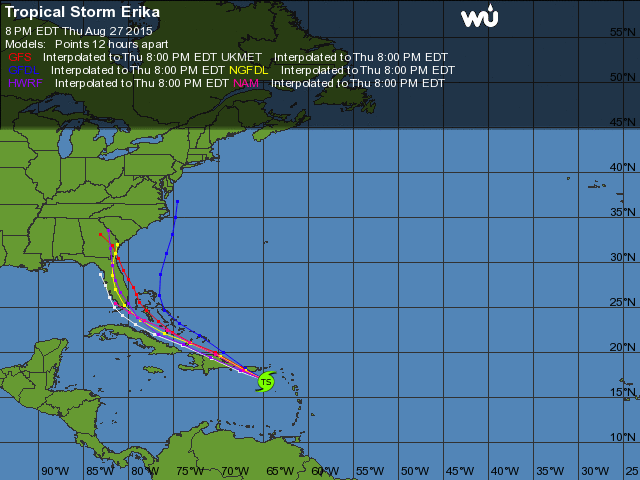
![]() by jmanley32 Thu Aug 27, 2015 9:08 pm
by jmanley32 Thu Aug 27, 2015 9:08 pm
jmanley32- Senior Enthusiast

- Posts : 20516
Join date : 2013-12-12
Re: *BLOG* Tropical Storm Erika
![]() by snow247 Thu Aug 27, 2015 9:17 pm
by snow247 Thu Aug 27, 2015 9:17 pm
If I had to guess:
Southeast states (mainly FL, GA, and SC): 50%
North Carolina: 40%
Our area: 10%
Last edited by snow247 on Thu Aug 27, 2015 9:28 pm; edited 1 time in total
snow247- Pro Enthusiast

- Posts : 2417
Join date : 2014-08-27
Re: *BLOG* Tropical Storm Erika
![]() by snow247 Thu Aug 27, 2015 9:22 pm
by snow247 Thu Aug 27, 2015 9:22 pm
Looks like it may be starting a very slight jog WNW.
Last edited by snow247 on Thu Aug 27, 2015 9:31 pm; edited 3 times in total

snow247- Pro Enthusiast
- Posts : 2417
Reputation : 0
Join date : 2014-08-27
Location : Mount Ivy, NY - Elevation 545'
Re: *BLOG* Tropical Storm Erika
![]() by jmanley32 Thu Aug 27, 2015 9:24 pm
by jmanley32 Thu Aug 27, 2015 9:24 pm

jmanley32- Senior Enthusiast
- Posts : 20516
Reputation : 108
Join date : 2013-12-12
Age : 42
Location : Yonkers, NY


Joe Snow- Pro Enthusiast
- Posts : 924
Reputation : 7
Join date : 2014-02-12
Age : 62
Location : Sanford Florida, Fmrly Kings Park, NY
Re: *BLOG* Tropical Storm Erika
![]() by snow247 Thu Aug 27, 2015 10:37 pm
by snow247 Thu Aug 27, 2015 10:37 pm
snow247 wrote:http://radar.weather.gov/radar.php?rid=JUA&product=N0Z&overlay=11101111&loop=yes
Looks like it may be starting a very slight jog WNW.

snow247- Pro Enthusiast
- Posts : 2417
Reputation : 0
Join date : 2014-08-27
Location : Mount Ivy, NY - Elevation 545'
Re: *BLOG* Tropical Storm Erika
![]() by amugs Thu Aug 27, 2015 11:07 pm
by amugs Thu Aug 27, 2015 11:07 pm

_________________
Mugs
AKA:King: Snow Weenie
Self Proclaimed
WINTER 2014-15 : 55.12" +.02 for 6 coatings (avg. 35")
WINTER 2015-16 Total - 29.8" (Avg 35")
WINTER 2016-17 : 39.5" so far

amugs- Advanced Forecaster - Mod

- Posts : 15093
Reputation : 213
Join date : 2013-01-07
Age : 54
Location : Hillsdale,NJ
Re: *BLOG* Tropical Storm Erika
![]() by snow247 Thu Aug 27, 2015 11:51 pm
by snow247 Thu Aug 27, 2015 11:51 pm
snow247- Pro Enthusiast
- Posts : 2417
Reputation : 0
Join date : 2014-08-27
Location : Mount Ivy, NY - Elevation 545'
snow247- Pro Enthusiast
- Posts : 2417
Reputation : 0
Join date : 2014-08-27
Location : Mount Ivy, NY - Elevation 545'
Re: *BLOG* Tropical Storm Erika
![]() by Joe Snow Fri Aug 28, 2015 12:21 am
by Joe Snow Fri Aug 28, 2015 12:21 am

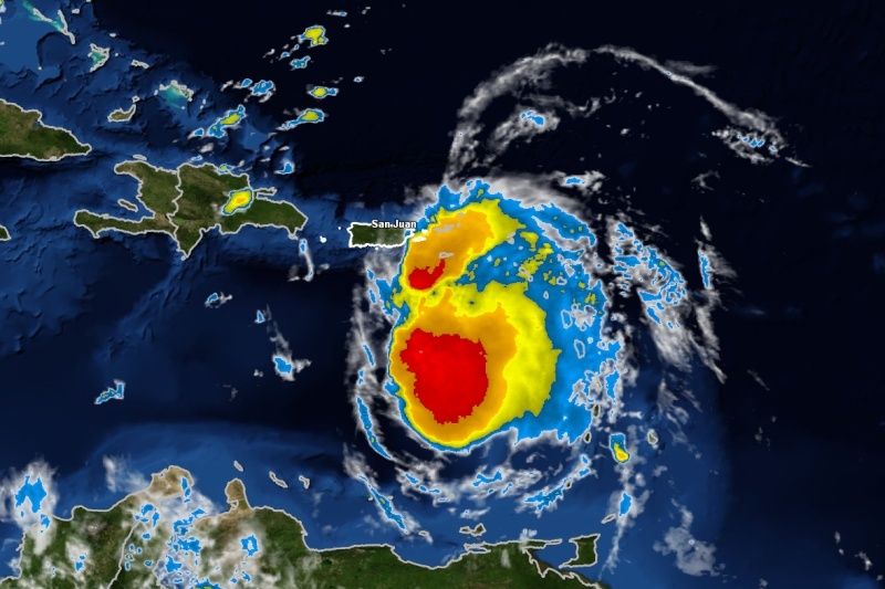
Current Radar Infra Red
Joe Snow- Pro Enthusiast
- Posts : 924
Reputation : 7
Join date : 2014-02-12
Age : 62
Location : Sanford Florida, Fmrly Kings Park, NY
Re: *BLOG* Tropical Storm Erika
![]() by algae888 Fri Aug 28, 2015 4:34 am
by algae888 Fri Aug 28, 2015 4:34 am
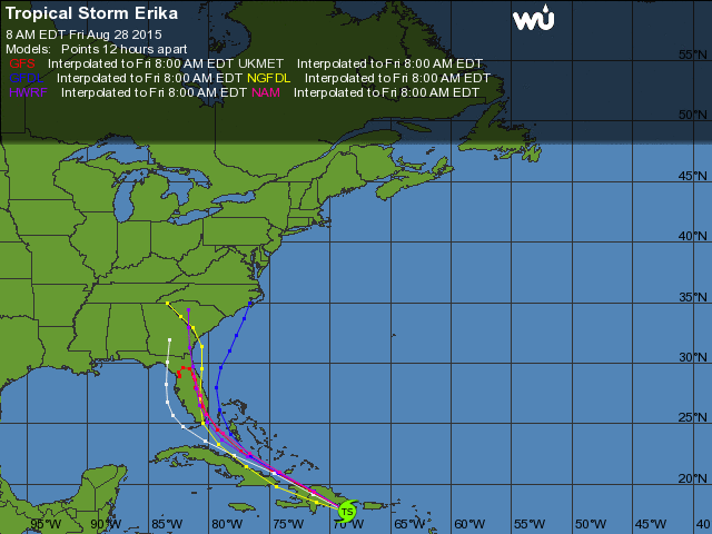
westward shift continues. look how it cuts right through Hispaniola.

algae888- Advanced Forecaster

- Posts : 5311
Reputation : 46
Join date : 2013-02-05
Age : 61
Location : mt. vernon, new york
Re: *BLOG* Tropical Storm Erika
![]() by algae888 Fri Aug 28, 2015 4:38 am
by algae888 Fri Aug 28, 2015 4:38 am
algae888- Advanced Forecaster
- Posts : 5311
Reputation : 46
Join date : 2013-02-05
Age : 61
Location : mt. vernon, new york
Re: *BLOG* Tropical Storm Erika
![]() by algae888 Fri Aug 28, 2015 4:40 am
by algae888 Fri Aug 28, 2015 4:40 am

I am also hearing euro lost her too.
algae888- Advanced Forecaster
- Posts : 5311
Reputation : 46
Join date : 2013-02-05
Age : 61
Location : mt. vernon, new york
Re: *BLOG* Tropical Storm Erika
![]() by algae888 Fri Aug 28, 2015 4:55 am
by algae888 Fri Aug 28, 2015 4:55 am

some of nhc 5am update...Strong shear is expected to continue or even increase during the
next day or so. The combination of the shear and interaction with
Hispaniola suggests that Erika is likely to weaken and could even
dissipate in the next 12 to 24 hours. Assuming that the cyclone
survives, there is an opportunity for some intensification on days
2 and 3 of the forecast period as the shear decreases, and that is
reflected in the NHC forecast. After that time, since the NHC track
now takes Erika inland over the Florida peninsula, weakening is
shown at days 4 and 5. Much of the guidance has trended weaker this
cycle, and the NHC intensity forecast is close to the HWRF and the
IVCN consensus. Confidence in the intensity forecast remains very
low.
The greatest short-term threat posed by Erika continues to be
very heavy rainfall over portions of the the Virgin Islands, Puerto
Rico, the Dominican Republic, and Haiti today. These rains could
produce flash floods and mud slides.
FORECAST POSITIONS AND MAX WINDS
INIT 28/0900Z 17.7N 67.7W 45 KT 50 MPH
12H 28/1800Z 18.8N 69.8W 40 KT 45 MPH...INLAND
24H 29/0600Z 20.5N 72.9W 40 KT 45 MPH...OVER WATER
36H 29/1800Z 22.0N 76.0W 40 KT 45 MPH
48H 30/0600Z 23.2N 78.1W 45 KT 50 MPH
72H 31/0600Z 25.6N 80.7W 50 KT 60 MPH...INLAND
96H 01/0600Z 27.7N 81.6W 45 KT 50 MPH...INLAND
120H 02/0600Z 30.0N 82.0W 40 KT 45 MPH...INLAND
algae888- Advanced Forecaster
- Posts : 5311
Reputation : 46
Join date : 2013-02-05
Age : 61
Location : mt. vernon, new york
Re: *BLOG* Tropical Storm Erika
![]() by jmanley32 Fri Aug 28, 2015 5:57 am
by jmanley32 Fri Aug 28, 2015 5:57 am
jmanley32- Senior Enthusiast
- Posts : 20516
Reputation : 108
Join date : 2013-12-12
Age : 42
Location : Yonkers, NY
Re: *BLOG* Tropical Storm Erika
![]() by Frank_Wx Fri Aug 28, 2015 6:15 am
by Frank_Wx Fri Aug 28, 2015 6:15 am
Old: "Right now I'll place 50% odds of coastal Carolina's getting hit, 30% Florida and southeast states, 20% our area."
New: Florida 60%, Carolina's 30%, NJ 10%
_________________
_______________________________________________________________________________________________________
CLICK HERE to view NJ Strong Snowstorm Classifications

Frank_Wx- Godzilla Seeker

- Posts : 21305
Reputation : 328
Join date : 2013-01-05
Age : 31
Location : Jersey City, NJ -

Re: *BLOG* Tropical Storm Erika
![]() by docstox12 Fri Aug 28, 2015 6:19 am
by docstox12 Fri Aug 28, 2015 6:19 am
The only spaghetti track I want to see is one out of the Gulf picking up that warm water and curving up the coast in Dec., Jan. or Feb. giving us another Boxing Day.

docstox12- Wx Statistician Guru

- Posts : 8504
Reputation : 222
Join date : 2013-01-07
Age : 73
Location : Monroe NY
Re: *BLOG* Tropical Storm Erika
![]() by sroc4 Fri Aug 28, 2015 8:16 am
by sroc4 Fri Aug 28, 2015 8:16 am
 " />
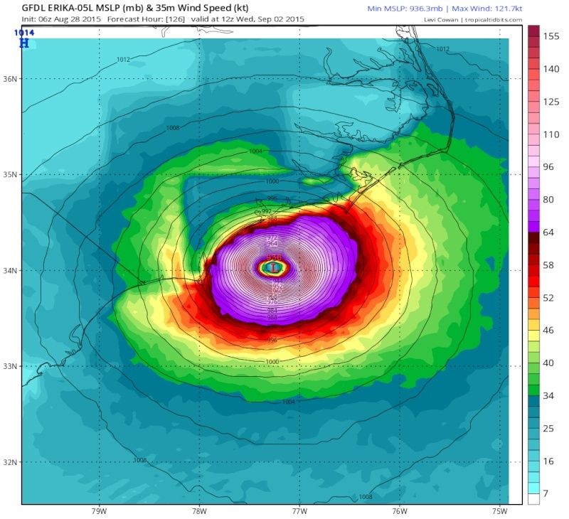
" />This map tells us a lot. This unexpected shift south yesterday is the main reason why we saw the track shift west. If it actually followed the track we though it was going to yesterday, black arrow there would have been much less interactions with PR and more importantly Hispanola today. This ultimately means a much weaker wave which is way more influenced by the steering layers. As you can see by this next image which shows the mean steering layer, the more southerly track leads to a later turn north and a route over more land lending to a much weaker system as it approaches Fla and nowhere for it to intensify, vs the just north of the islands track which would have had the center less influenced by the mountains of the islands and a turn N sooner off the SE Fla coast where the bath water is for intensification. It aint over till the fat lady sings but the Cat 5 on the GFDL yesterday off the outer banks is highly unlikely at this stage.
 " />
" />_________________
"In weather and in life, there's no winning and losing; there's only winning and learning."
WINTER 2012/2013 TOTALS 43.65"WINTER 2017/2018 TOTALS 62.85" WINTER 2022/2023 TOTALS 4.9"
WINTER 2013/2014 TOTALS 64.85"WINTER 2018/2019 TOTALS 14.25" WINTER 2023/2024 TOTALS 13.1"
WINTER 2014/2015 TOTALS 71.20"WINTER 2019/2020 TOTALS 6.35"
WINTER 2015/2016 TOTALS 35.00"WINTER 2020/2021 TOTALS 37.75"
WINTER 2016/2017 TOTALS 42.25"WINTER 2021/2022 TOTALS 31.65"

sroc4- Admin
- Posts : 8331
Reputation : 301
Join date : 2013-01-07
Location : Wading River, LI
Re: *BLOG* Tropical Storm Erika
![]() by jmanley32 Fri Aug 28, 2015 8:41 am
by jmanley32 Fri Aug 28, 2015 8:41 am
jmanley32- Senior Enthusiast
- Posts : 20516
Reputation : 108
Join date : 2013-12-12
Age : 42
Location : Yonkers, NY
Re: *BLOG* Tropical Storm Erika
![]() by jmanley32 Fri Aug 28, 2015 9:05 am
by jmanley32 Fri Aug 28, 2015 9:05 am
jmanley32- Senior Enthusiast
- Posts : 20516
Reputation : 108
Join date : 2013-12-12
Age : 42
Location : Yonkers, NY
jmanley32- Senior Enthusiast
- Posts : 20516
Reputation : 108
Join date : 2013-12-12
Age : 42
Location : Yonkers, NY
Re: *BLOG* Tropical Storm Erika
![]() by sroc4 Fri Aug 28, 2015 9:29 am
by sroc4 Fri Aug 28, 2015 9:29 am
_________________
"In weather and in life, there's no winning and losing; there's only winning and learning."
WINTER 2012/2013 TOTALS 43.65"WINTER 2017/2018 TOTALS 62.85" WINTER 2022/2023 TOTALS 4.9"
WINTER 2013/2014 TOTALS 64.85"WINTER 2018/2019 TOTALS 14.25" WINTER 2023/2024 TOTALS 13.1"
WINTER 2014/2015 TOTALS 71.20"WINTER 2019/2020 TOTALS 6.35"
WINTER 2015/2016 TOTALS 35.00"WINTER 2020/2021 TOTALS 37.75"
WINTER 2016/2017 TOTALS 42.25"WINTER 2021/2022 TOTALS 31.65"
sroc4- Admin
- Posts : 8331
Reputation : 301
Join date : 2013-01-07
Location : Wading River, LI
Re: *BLOG* Tropical Storm Erika
![]() by sroc4 Fri Aug 28, 2015 9:37 am
by sroc4 Fri Aug 28, 2015 9:37 am
jmanley32 wrote:
JMan this is a quote from someone on another board..."the GFDL has been the most consistent model..... its either smoking something good or its onto something"
We track
_________________
"In weather and in life, there's no winning and losing; there's only winning and learning."
WINTER 2012/2013 TOTALS 43.65"WINTER 2017/2018 TOTALS 62.85" WINTER 2022/2023 TOTALS 4.9"
WINTER 2013/2014 TOTALS 64.85"WINTER 2018/2019 TOTALS 14.25" WINTER 2023/2024 TOTALS 13.1"
WINTER 2014/2015 TOTALS 71.20"WINTER 2019/2020 TOTALS 6.35"
WINTER 2015/2016 TOTALS 35.00"WINTER 2020/2021 TOTALS 37.75"
WINTER 2016/2017 TOTALS 42.25"WINTER 2021/2022 TOTALS 31.65"
sroc4- Admin
- Posts : 8331
Reputation : 301
Join date : 2013-01-07
Location : Wading River, LI
Re: *BLOG* Tropical Storm Erika
![]() by Guest Fri Aug 28, 2015 9:41 am
by Guest Fri Aug 28, 2015 9:41 am
sroc4 wrote:jmanley32 wrote:
JMan this is a quote from someone on another board..."the GFDL has been the most consistent model..... its either smoking something good or its onto something"
We track
I hope its onto something!!!
Guest- Guest
Re: *BLOG* Tropical Storm Erika
![]() by jmanley32 Fri Aug 28, 2015 9:48 am
by jmanley32 Fri Aug 28, 2015 9:48 am
jmanley32- Senior Enthusiast
- Posts : 20516
Reputation : 108
Join date : 2013-12-12
Age : 42
Location : Yonkers, NY
Re: *BLOG* Tropical Storm Erika
![]() by jmanley32 Fri Aug 28, 2015 10:51 am
by jmanley32 Fri Aug 28, 2015 10:51 am
jmanley32- Senior Enthusiast
- Posts : 20516
Reputation : 108
Join date : 2013-12-12
Age : 42
Location : Yonkers, NY
Re: *BLOG* Tropical Storm Erika
![]() by skinsfan1177 Fri Aug 28, 2015 11:03 am
by skinsfan1177 Fri Aug 28, 2015 11:03 am

skinsfan1177- Senior Enthusiast
- Posts : 4485
Reputation : 35
Join date : 2013-01-07
Age : 46
Location : Point Pleasant Boro
Page 6 of 8 • 1, 2, 3, 4, 5, 6, 7, 8 ![]()
|
|
|