
 Search
*BLOG* Tropical Storm Erika
Page 2 of 8 •  1, 2, 3, 4, 5, 6, 7, 8
 ![]()
snow247- Pro Enthusiast

- Posts : 2417
Join date : 2014-08-27
Re: *BLOG* Tropical Storm Erika
![]() by snow247 Thu Aug 27, 2015 1:09 am
by snow247 Thu Aug 27, 2015 1:09 am
snow247- Pro Enthusiast
- Posts : 2417
Join date : 2014-08-27
Re: *BLOG* Tropical Storm Erika
![]() by sroc4 Thu Aug 27, 2015 8:36 am
by sroc4 Thu Aug 27, 2015 8:36 am

As you can see there is a really nice convection which may lead you to believe she is healthy and poss strengthening. However; the entire system is decoupled from the low level center(LLC) and the spin in the mid and upper levels which means we prob wont see much strengthening until the spin in the diff layers of the atmosphere becomes more vertically stacked as well as the LLC moves into a more favorable environment. Let me explain.
First image is 850mb vorticity(spin) Notice the center of circulation is shifted S of the LLC. Second image is 500mb vorticity and its center of circulation is S and well east.
 " />
" /> " />
" />What you want to see is the centers of vorticity centered over the same Lat and Longitude as the LLC. So why does the convection look so good at the moment on the Sat loop? The next image is the wind shear map followed by the upper level divergence map. On the wind shear map, however, are also the winds in the upper levels (blue arrows). Notice how over the top of Ericka's convection center you have one arrow moving E to NE, and the other moving E to SE. The winds over top of Erika are diverging or moving away from each other. This forces the air in the lower levels to rise to replace the air that has moved out of the upper levels. Rising air equals convection and thunderstorms. In order for a tropical system to strengthen you want those upper level winds to move away from(diverge) in all 4 quadrants from th center of circulation. You can see clearly that is not the case here. Instead you are only getting divergence in the NE and SE quadrants. But again there is divergence aloft so you get good convection underneath, but its to the S and E of the LLC.
 " />
" /> " />
" />The next 3 days will be interesting to see how Erika hold up. Again looking at the wind shear map I have above notice I outlined in black the wind shear contours. They indicate that Erika has to pass through a gauntlet of mild-mod wind shear(10-20Kts) before she enters the area of the Bahamas and Turks and Caicos where the wind shear drops off. She also still has some dry air to contend with out in front of her to the W and NW(see below)
 " />
" />So for now because there is a decoupling in the various layers of the atmosphere, dry air, some wind shear, and the currently unknown interactions with the islands out ahead of her the models will cont to waffle a bit in their solns beyond the 3-5day. Things should stat to become clearer as we move into the next 3 days or so. One thing I will say is when I look at the upper level pattern developing over the NE and Atlantic and even out west I get concerned that a track that moves Erika off the coast N and E followed by a recurve back to the NW towards the coast again is something Im monitoring closely. I have some things saved to support that idea and will try to postit later as I have run out of time this morning. FINALLY something interesting to track....Its good to be back.
_________________
"In weather and in life, there's no winning and losing; there's only winning and learning."
WINTER 2012/2013 TOTALS 43.65"WINTER 2017/2018 TOTALS 62.85" WINTER 2022/2023 TOTALS 4.9"
WINTER 2013/2014 TOTALS 64.85"WINTER 2018/2019 TOTALS 14.25" WINTER 2023/2024 TOTALS 13.1"
WINTER 2014/2015 TOTALS 71.20"WINTER 2019/2020 TOTALS 6.35"
WINTER 2015/2016 TOTALS 35.00"WINTER 2020/2021 TOTALS 37.75"
WINTER 2016/2017 TOTALS 42.25"WINTER 2021/2022 TOTALS 31.65"

sroc4- Admin

- Posts : 8331
Reputation : 301
Join date : 2013-01-07
Location : Wading River, LI
Re: *BLOG* Tropical Storm Erika
![]() by algae888 Thu Aug 27, 2015 8:39 am
by algae888 Thu Aug 27, 2015 8:39 am

96hrs day 4

192hrs day 8

312hrs day 13
incredible!! if that happens

algae888- Advanced Forecaster

- Posts : 5311
Reputation : 46
Join date : 2013-02-05
Age : 61
Location : mt. vernon, new york
Re: *BLOG* Tropical Storm Erika
![]() by algae888 Thu Aug 27, 2015 8:51 am
by algae888 Thu Aug 27, 2015 8:51 am
algae888- Advanced Forecaster
- Posts : 5311
Reputation : 46
Join date : 2013-02-05
Age : 61
Location : mt. vernon, new york
Re: *BLOG* Tropical Storm Erika
![]() by amugs Thu Aug 27, 2015 9:04 am
by amugs Thu Aug 27, 2015 9:04 am
_________________
Mugs
AKA:King: Snow Weenie
Self Proclaimed
WINTER 2014-15 : 55.12" +.02 for 6 coatings (avg. 35")
WINTER 2015-16 Total - 29.8" (Avg 35")
WINTER 2016-17 : 39.5" so far

amugs- Advanced Forecaster - Mod

- Posts : 15093
Reputation : 213
Join date : 2013-01-07
Age : 54
Location : Hillsdale,NJ
Re: *BLOG* Tropical Storm Erika
![]() by sroc4 Thu Aug 27, 2015 9:06 am
by sroc4 Thu Aug 27, 2015 9:06 am
algae888 wrote:scott nice to hear from you and nice write up. i didn't think Erika was going to make it but when she hits the florida coast she has no where to go and that is concerning. steering flow very weak in s/e U.S. with ridge strengthening over north east. what she does and how strong she gets is any ones guess right now. it is going to be awhile before we are rid of her.
Yeah Al. With so many variables between now and when she gets into the Bahamas we most likely will see solns cont to waffle. I will be monitoring the trends at 500mb at when and how the current mid level trough moves into the Canadian maritime, followed by the ridge building into the NE in its place, and IF the ridge builds in strong enough does it link up with the SW Atlantic ridge currently steering Erika? Combine all that with the timing, intensity, track, etc of Erika as she continues her W NW journey into the Bahamas. Fun times ahead!!
_________________
"In weather and in life, there's no winning and losing; there's only winning and learning."
WINTER 2012/2013 TOTALS 43.65"WINTER 2017/2018 TOTALS 62.85" WINTER 2022/2023 TOTALS 4.9"
WINTER 2013/2014 TOTALS 64.85"WINTER 2018/2019 TOTALS 14.25" WINTER 2023/2024 TOTALS 13.1"
WINTER 2014/2015 TOTALS 71.20"WINTER 2019/2020 TOTALS 6.35"
WINTER 2015/2016 TOTALS 35.00"WINTER 2020/2021 TOTALS 37.75"
WINTER 2016/2017 TOTALS 42.25"WINTER 2021/2022 TOTALS 31.65"
sroc4- Admin
- Posts : 8331
Reputation : 301
Join date : 2013-01-07
Location : Wading River, LI
Re: *BLOG* Tropical Storm Erika
![]() by amugs Thu Aug 27, 2015 9:14 am
by amugs Thu Aug 27, 2015 9:14 am
The summer hiatus is over huh?Great to hear from u Paisan and glad to see you posting. Analysis is always much appreciated, in depth and educational besides awesome accurate work.
Can not go beyond a few days with these canes and we should learn from past experience how quickly they can change. She is a biag that will make it thought the Bahamas and then say Hello as she enters into the area where she can strengthen, reorganize. Time will tell and the models will waffle big time
_________________
Mugs
AKA:King: Snow Weenie
Self Proclaimed
WINTER 2014-15 : 55.12" +.02 for 6 coatings (avg. 35")
WINTER 2015-16 Total - 29.8" (Avg 35")
WINTER 2016-17 : 39.5" so far
amugs- Advanced Forecaster - Mod
- Posts : 15093
Reputation : 213
Join date : 2013-01-07
Age : 54
Location : Hillsdale,NJ
Re: *BLOG* Tropical Storm Erika
![]() by sroc4 Thu Aug 27, 2015 9:46 am
by sroc4 Thu Aug 27, 2015 9:46 am
 " />
" />Look at the ridge building into the NE. As the long wave trough pushes east across the country is will force the ridge to build over top into eastern canada. This could lead to a strong blocking signature ala HP to the NE esp if the ridge over top connects to the SW Atlantic ridge. As the trough out west approaches the coast in theory could start to pull Erika back to the coast similar to the way Sandy was pulled back.
Again not likely to happen at this time. but is still a plausable soln given the pattern. I suppose, like looking at a good winter storm in the LR, we still have to monitor the trends in the upper levels over time, and monitor the details of Erika in the short term as she continues through the dry air, shear, and interactions with the islands between the eastern Caribean and the Bahamas.
_________________
"In weather and in life, there's no winning and losing; there's only winning and learning."
WINTER 2012/2013 TOTALS 43.65"WINTER 2017/2018 TOTALS 62.85" WINTER 2022/2023 TOTALS 4.9"
WINTER 2013/2014 TOTALS 64.85"WINTER 2018/2019 TOTALS 14.25" WINTER 2023/2024 TOTALS 13.1"
WINTER 2014/2015 TOTALS 71.20"WINTER 2019/2020 TOTALS 6.35"
WINTER 2015/2016 TOTALS 35.00"WINTER 2020/2021 TOTALS 37.75"
WINTER 2016/2017 TOTALS 42.25"WINTER 2021/2022 TOTALS 31.65"
sroc4- Admin
- Posts : 8331
Reputation : 301
Join date : 2013-01-07
Location : Wading River, LI
Re: *BLOG* Tropical Storm Erika
![]() by jmanley32 Thu Aug 27, 2015 10:06 am
by jmanley32 Thu Aug 27, 2015 10:06 am

jmanley32- Senior Enthusiast

- Posts : 20516
Reputation : 108
Join date : 2013-12-12
Age : 42
Location : Yonkers, NY
Re: *BLOG* Tropical Storm Erika
![]() by jmanley32 Thu Aug 27, 2015 10:29 am
by jmanley32 Thu Aug 27, 2015 10:29 am
algae888 wrote:scott nice to hear from you and nice write up. i didn't think Erika was going to make it but when she hits the florida coast she has no where to go and that is concerning. steering flow very weak in s/e U.S. with ridge strengthening over north east. what she does and how strong she gets is any ones guess right now. it is going to be awhile before we are rid of her.
See Al I told you these things can and do make surprises more so than the winter systems (errm well Juno a exception), yet a lot can still change, got one more hostile area to go through but if the blowup of convection keeps up she will make it as she is still moving pretty fast at 16mph, I also read that she is wobbling south a bit which would take her even further west possibly, not go b a good look off SE coast, anyone on EC should put some preps in place IMO, I am sure at least some of us have interests all up and down the EC.
jmanley32- Senior Enthusiast
- Posts : 20516
Reputation : 108
Join date : 2013-12-12
Age : 42
Location : Yonkers, NY
Re: *BLOG* Tropical Storm Erika
![]() by jmanley32 Thu Aug 27, 2015 10:30 am
by jmanley32 Thu Aug 27, 2015 10:30 am
algae888 wrote:the 6zgfs has Erika off the east coast for more than a week...
96hrs day 4
192hrs day 8
312hrs day 13
incredible!! if that happens
That will drive me loco if it happens lol, wheres she going...nowhere! Great so what now lol, its all wait and see.
jmanley32- Senior Enthusiast
- Posts : 20516
Reputation : 108
Join date : 2013-12-12
Age : 42
Location : Yonkers, NY
Re: *BLOG* Tropical Storm Erika
![]() by sroc4 Thu Aug 27, 2015 10:32 am
by sroc4 Thu Aug 27, 2015 10:32 am
_________________
"In weather and in life, there's no winning and losing; there's only winning and learning."
WINTER 2012/2013 TOTALS 43.65"WINTER 2017/2018 TOTALS 62.85" WINTER 2022/2023 TOTALS 4.9"
WINTER 2013/2014 TOTALS 64.85"WINTER 2018/2019 TOTALS 14.25" WINTER 2023/2024 TOTALS 13.1"
WINTER 2014/2015 TOTALS 71.20"WINTER 2019/2020 TOTALS 6.35"
WINTER 2015/2016 TOTALS 35.00"WINTER 2020/2021 TOTALS 37.75"
WINTER 2016/2017 TOTALS 42.25"WINTER 2021/2022 TOTALS 31.65"
sroc4- Admin
- Posts : 8331
Reputation : 301
Join date : 2013-01-07
Location : Wading River, LI
Re: *BLOG* Tropical Storm Erika
![]() by jmanley32 Thu Aug 27, 2015 10:35 am
by jmanley32 Thu Aug 27, 2015 10:35 am
jmanley32- Senior Enthusiast
- Posts : 20516
Reputation : 108
Join date : 2013-12-12
Age : 42
Location : Yonkers, NY
Re: *BLOG* Tropical Storm Erika
![]() by jmanley32 Thu Aug 27, 2015 10:36 am
by jmanley32 Thu Aug 27, 2015 10:36 am
sroc4 wrote:Hey there Jman! Good to be back...just an FYI if it did take a hook towards the coast esp up by us most likely would weaken significantly before landfall as the water temps North of Cape Hatt cool significantly.
sroc, aren't they warmer than usual though off the coast, I saw a map from wxbell that showed SSTS much higher than normal.
jmanley32- Senior Enthusiast
- Posts : 20516
Reputation : 108
Join date : 2013-12-12
Age : 42
Location : Yonkers, NY
Re: *BLOG* Tropical Storm Erika
![]() by algae888 Thu Aug 27, 2015 11:17 am
by algae888 Thu Aug 27, 2015 11:17 am
algae888- Advanced Forecaster
- Posts : 5311
Reputation : 46
Join date : 2013-02-05
Age : 61
Location : mt. vernon, new york
Re: *BLOG* Tropical Storm Erika
![]() by algae888 Thu Aug 27, 2015 11:24 am
by algae888 Thu Aug 27, 2015 11:24 am
algae888- Advanced Forecaster
- Posts : 5311
Reputation : 46
Join date : 2013-02-05
Age : 61
Location : mt. vernon, new york
Re: *BLOG* Tropical Storm Erika
![]() by Frank_Wx Thu Aug 27, 2015 11:38 am
by Frank_Wx Thu Aug 27, 2015 11:38 am
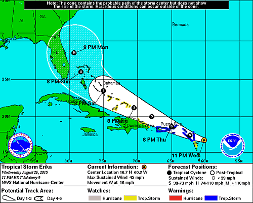
National Hurricane Center wrote:Erika is not well organized at this time. Although deep convection
increased overnight and early today during the diurnal maximum,
with considerable lightning activity, banding features were
lacking. The convection is also not well organized on the
Guadeloupe radar imagery. Recent high-resolution visible imagery
shows the low-level center becoming exposed, again, to the
northwest of the main area of thunderstorms. Data from the aircraft
do not indicate any strengthening, and the initial intensity is kept
at 45 kt.
The latest aircraft fixes show that the center has apparently
reformed farther to the south of previous estimates. With some
adjustments to the previous location, the initial motion estimate is
kept at 270/14. For the next few days, Erika should move
west-northwestward to the south of a mid-level subtropical ridge.
Later in the forecast period, as the tropical cyclone nears the
western periphery of the ridge, a turn to the northwest and
north-northwest should occur. However there is uncertainty as to
how soon and how sharp this turn will take place. The future track
of Erika is also dependent on its intensity, with a weaker system
likely to move more to the west and a stronger cyclone more to the
east. There is substantial spread in the track models at days 3 to
5, partially due to differences in model-predicted intensity. The
official track forecast has been shifted to the left of the previous
one mainly due to the adjustment in the current center position.
This is close to the model consensus.
As expected, Erika is being disrupted by an unfavorable atmospheric
environment, and this disruption is expected to continue for the
next couple of days. No significant strengthening is expected until
later in the forecast period. In addition, with the reformation of
the center to the south of the previous track, the likelihood of
interaction with the land mass of Hispaniola has increased. This
has implications for Hispaniola, of course, but also for the track
and intensity of Erika after that. In short, potential impacts for
the Bahamas and beyond are unusually uncertain.
_________________
_______________________________________________________________________________________________________
CLICK HERE to view NJ Strong Snowstorm Classifications

Frank_Wx- Godzilla Seeker
- Posts : 21305
Reputation : 328
Join date : 2013-01-05
Age : 31
Location : Jersey City, NJ -

Re: *BLOG* Tropical Storm Erika
![]() by Frank_Wx Thu Aug 27, 2015 11:40 am
by Frank_Wx Thu Aug 27, 2015 11:40 am
_________________
_______________________________________________________________________________________________________
CLICK HERE to view NJ Strong Snowstorm Classifications
Frank_Wx- Godzilla Seeker
- Posts : 21305
Reputation : 328
Join date : 2013-01-05
Age : 31
Location : Jersey City, NJ -
Re: *BLOG* Tropical Storm Erika
![]() by jmanley32 Thu Aug 27, 2015 11:53 am
by jmanley32 Thu Aug 27, 2015 11:53 am
jmanley32- Senior Enthusiast
- Posts : 20516
Reputation : 108
Join date : 2013-12-12
Age : 42
Location : Yonkers, NY
Re: *BLOG* Tropical Storm Erika
![]() by algae888 Thu Aug 27, 2015 11:54 am
by algae888 Thu Aug 27, 2015 11:54 am
algae888- Advanced Forecaster
- Posts : 5311
Reputation : 46
Join date : 2013-02-05
Age : 61
Location : mt. vernon, new york
Re: *BLOG* Tropical Storm Erika
![]() by sroc4 Thu Aug 27, 2015 12:24 pm
by sroc4 Thu Aug 27, 2015 12:24 pm
Frank_Wx wrote:@Scott - nice write up and glad to see you out of hibernation. One thing I did not see you mention is the ULL in the southeast. There have been some sloppy phases between the ULL and Erika on previous model runs, but last night's GFS showed a cleaner phase which allowed Erika to move in over land. In a way, this could also turn into a Rex Block scenario.
Yeah I actually plan on discussing that after seeing the 12z GFS today. Its a splits off the trough currently in the east and should act to prevent it from entering the GOM and provide ventelation in the upper levels for strengthening once it reaches the SE coast. Question is what is left to work with by that point
_________________
"In weather and in life, there's no winning and losing; there's only winning and learning."
WINTER 2012/2013 TOTALS 43.65"WINTER 2017/2018 TOTALS 62.85" WINTER 2022/2023 TOTALS 4.9"
WINTER 2013/2014 TOTALS 64.85"WINTER 2018/2019 TOTALS 14.25" WINTER 2023/2024 TOTALS 13.1"
WINTER 2014/2015 TOTALS 71.20"WINTER 2019/2020 TOTALS 6.35"
WINTER 2015/2016 TOTALS 35.00"WINTER 2020/2021 TOTALS 37.75"
WINTER 2016/2017 TOTALS 42.25"WINTER 2021/2022 TOTALS 31.65"
sroc4- Admin
- Posts : 8331
Reputation : 301
Join date : 2013-01-07
Location : Wading River, LI
Re: *BLOG* Tropical Storm Erika
![]() by algae888 Thu Aug 27, 2015 12:36 pm
by algae888 Thu Aug 27, 2015 12:36 pm
algae888- Advanced Forecaster
- Posts : 5311
Reputation : 46
Join date : 2013-02-05
Age : 61
Location : mt. vernon, new york
Re: *BLOG* Tropical Storm Erika
![]() by algae888 Thu Aug 27, 2015 12:42 pm
by algae888 Thu Aug 27, 2015 12:42 pm
algae888- Advanced Forecaster
- Posts : 5311
Reputation : 46
Join date : 2013-02-05
Age : 61
Location : mt. vernon, new york
Re: *BLOG* Tropical Storm Erika
![]() by snow247 Thu Aug 27, 2015 12:57 pm
by snow247 Thu Aug 27, 2015 12:57 pm
Last edited by snow247 on Thu Aug 27, 2015 1:08 pm; edited 1 time in total

snow247- Pro Enthusiast
- Posts : 2417
Reputation : 0
Join date : 2014-08-27
Location : Mount Ivy, NY - Elevation 545'
Re: *BLOG* Tropical Storm Erika
![]() by snow247 Thu Aug 27, 2015 1:02 pm
by snow247 Thu Aug 27, 2015 1:02 pm
snow247- Pro Enthusiast
- Posts : 2417
Reputation : 0
Join date : 2014-08-27
Location : Mount Ivy, NY - Elevation 545'
Re: *BLOG* Tropical Storm Erika
![]() by snow247 Thu Aug 27, 2015 1:05 pm
by snow247 Thu Aug 27, 2015 1:05 pm
snow247- Pro Enthusiast
- Posts : 2417
Reputation : 0
Join date : 2014-08-27
Location : Mount Ivy, NY - Elevation 545'
Page 2 of 8 • 1, 2, 3, 4, 5, 6, 7, 8 ![]()
|
|
|