
 Search
Feb 9th-10th IVT Update 2.0
Page 1 of 7 • 1, 2, 3, 4, 5, 6, 7 ![]()

Feb 9th-10th IVT Update 2.0
![]() by sroc4 Tue Feb 09, 2016 8:31 am
by sroc4 Tue Feb 09, 2016 8:31 am
Wave two was Early morning Monday into Monday night. I originally thought that this was going to end up well S and East of us and not affect the North East at all; however, as has been the trend this winter the hi resolution short range weather models trended back to the northwest with the final solution inside of 48-72hrs. Now normally a track that yesterdays system took would have missed our area completely; however, it was an absolute beast of a storm. It had a central pressure comparable to a Cat 1-2 hurricane. As a result it sent bands of precipitation hundreds of miles from its center into our area giving most if not all of Long Island measurable snowfall. Totals increased from west to east from a coating to an inch up to about 6-7 inches out on the south fork.
So what's the deal with the Tuesday system. Again last week I really thought this system would be the one to deliver a wide spread thumping to the tri state metropolitan area that could have delivered 6-12"+ type totals. That, unfort or fort depending on your preference, does not appear to be happening. I can still see where everyone gets at least a general light accumulation(1-3");however, on more of localized level more moderate accumulations are still possible between Tuesday and Thursday. Here is why.
Lets refer to the first map below. The beast of a system that moved well to our south and east and is now pummeling Nova Scotia and the Canadian Maritime is simply too close to the second system which is currently centered east of Cape Hatteras NC. There are 3 surface LP centeres in relative close proximity. Notice in the image that the area in between all three low press centers there is no precip(blue circle). That is because air at the surface is moving away from that area towards all three of the surface LP centeres. This is termed divergence. When occuring at the surface the air that moves out of one location needs to be replaced. The air above it in the atmosphere sinks in these areas to achieve this. As we know sinking air (subsidence) IS NOT conducive to snowfall. In addition to being too close it is a tad too far west. If the original idea of well OTS and east occured it may have allowed room for this next system to head north up the coast inbetween the LP in the great lakes and the Monday beast. But because it, Mondays system, took a track a little further north and west closer to the coast, it is forcing this next system to track more east north east underneath it, instead of north strait up the coast in between. If you look at the upper levels you can see why this happens, but for simplicity and time I will not get into that any further.


Lets focus our attention back now on the LP centered over the great lakes and the one just off the NC coast. This was the set up I thought was going to give us the widespread significant snowfall. What is actually happening here? Well Sunday into Monday the LP moved into the great lakes and began to transfer energy to the coast re-developing a second low pressure center that exited the coast around the VA/NC coastline. The interaction between these two LP's and the energy swirling around in the upper levels that generated these LP's is whats going to lead to widespread light snowfall accumulations with localized mod to heavy accumulations.
Below is a close up view of the map above. The development of a Norlun trough(named after the two meteorologists who first identified this feature) (aka Inverted trough(IVT)) is going to bring areas to our south localized mod-heavy snowfall. These things are really tough to predict exactly where they set up and even more difficult to predict how much snow will actually fall underneath them.
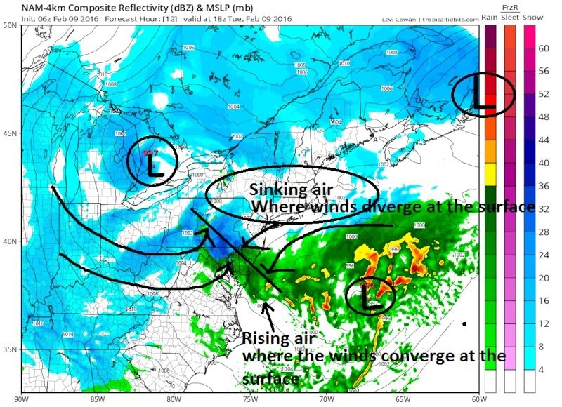
Simply stated...What happens is due to the counter clockwise winds around the two LP centers there develops an area of Convergence(air crashes into itself)) between the two LP centers when they are close enough to each other. Where this air comes together at the surface it is forced upward rapidly which leads to the formation of precipitation in a narrow band along this boundary. There is more to this but that is the general idea.
The main area, as you can see above, affected by the IVT for today is well to our south affecting DC area, Delmarva, and S NJ. However; it appears models are trying to develop a second LP center after the one from the image above moves out, somewhere south of long Island late tonight into Wed. The precipitation that develops from this is not as strait forward as a "traditional" coastal. This too is set up by the interactions between the newly formed LP south of LI and the LP that cont to move east through the Great Lakes to the north. Again an inverted trough axis tries to develop. There is also a lot of energy in the mid levels(yellows in the image below) that will rotate through and over this axis that could trigger mod to heavy snow bands that cannot be predicted until within a very short window.

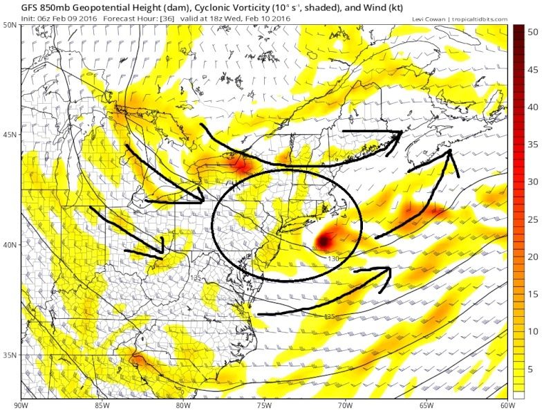
So you have unstable air rotating through the region in the mid levels, a second LP center, and a potential second IVT axis(although not as well defined as the one today) that could lead to localized mod-heavy snow bands developing due to very unstable air. Again these types of set ups are extremely tough to forecast. So while I am calling for a generalized 1-3" for most of our area, if ones back yard were to be under one of these heavier bands, should they develop , could pick up 3-6" max additional snowfall between now and Thursday in addition to the general 1-3" Im predicting.
Last edited by sroc4 on Tue Feb 09, 2016 10:47 am; edited 2 times in total
_________________
"In weather and in life, there's no winning and losing; there's only winning and learning."
WINTER 2012/2013 TOTALS 43.65"WINTER 2017/2018 TOTALS 62.85" WINTER 2022/2023 TOTALS 4.9"
WINTER 2013/2014 TOTALS 64.85"WINTER 2018/2019 TOTALS 14.25" WINTER 2023/2024 TOTALS 13.1"
WINTER 2014/2015 TOTALS 71.20"WINTER 2019/2020 TOTALS 6.35"
WINTER 2015/2016 TOTALS 35.00"WINTER 2020/2021 TOTALS 37.75"
WINTER 2016/2017 TOTALS 42.25"WINTER 2021/2022 TOTALS 31.65"

sroc4- Admin

- Posts : 8331
Reputation : 301
Join date : 2013-01-07
Location : Wading River, LI
Re: Feb 9th-10th IVT Update 2.0
![]() by Guest Tue Feb 09, 2016 8:38 am
by Guest Tue Feb 09, 2016 8:38 am
Guest- Guest
rb924119- Meteorologist

- Posts : 6890
Reputation : 194
Join date : 2013-02-06
Age : 32
Location : Greentown, Pa
Re: Feb 9th-10th IVT Update 2.0
![]() by sroc4 Tue Feb 09, 2016 8:45 am
by sroc4 Tue Feb 09, 2016 8:45 am
rb924119 wrote:Great disco, Scott!!
Thanks. Im interested in hearing what you have to say.
_________________
"In weather and in life, there's no winning and losing; there's only winning and learning."
WINTER 2012/2013 TOTALS 43.65"WINTER 2017/2018 TOTALS 62.85" WINTER 2022/2023 TOTALS 4.9"
WINTER 2013/2014 TOTALS 64.85"WINTER 2018/2019 TOTALS 14.25" WINTER 2023/2024 TOTALS 13.1"
WINTER 2014/2015 TOTALS 71.20"WINTER 2019/2020 TOTALS 6.35"
WINTER 2015/2016 TOTALS 35.00"WINTER 2020/2021 TOTALS 37.75"
WINTER 2016/2017 TOTALS 42.25"WINTER 2021/2022 TOTALS 31.65"
sroc4- Admin
- Posts : 8331
Reputation : 301
Join date : 2013-01-07
Location : Wading River, LI
Re: Feb 9th-10th IVT Update 2.0
![]() by sroc4 Tue Feb 09, 2016 8:48 am
by sroc4 Tue Feb 09, 2016 8:48 am
syosnow94 wrote:Nice analysis sroc4. Read the upton discussion for our area. Very bullish! Which for them is unusual!
Just read their discussion. This will def be a fluid/dynamic type now cast situation. There is no way anyone can nail down the details with this one. I think many are close and someone may pin the tail right on the right spot of the donkey, but it would be by luck that it was perfect, but overall this is a matter of getting close then seeing how it all unfolds.
_________________
"In weather and in life, there's no winning and losing; there's only winning and learning."
WINTER 2012/2013 TOTALS 43.65"WINTER 2017/2018 TOTALS 62.85" WINTER 2022/2023 TOTALS 4.9"
WINTER 2013/2014 TOTALS 64.85"WINTER 2018/2019 TOTALS 14.25" WINTER 2023/2024 TOTALS 13.1"
WINTER 2014/2015 TOTALS 71.20"WINTER 2019/2020 TOTALS 6.35"
WINTER 2015/2016 TOTALS 35.00"WINTER 2020/2021 TOTALS 37.75"
WINTER 2016/2017 TOTALS 42.25"WINTER 2021/2022 TOTALS 31.65"
sroc4- Admin
- Posts : 8331
Reputation : 301
Join date : 2013-01-07
Location : Wading River, LI
Re: Feb 9th-10th IVT Update 2.0
![]() by jmanley32 Tue Feb 09, 2016 9:00 am
by jmanley32 Tue Feb 09, 2016 9:00 am

jmanley32- Senior Enthusiast

- Posts : 20517
Reputation : 108
Join date : 2013-12-12
Age : 42
Location : Yonkers, NY
Re: Feb 9th-10th IVT Update 2.0
![]() by sroc4 Tue Feb 09, 2016 9:08 am
by sroc4 Tue Feb 09, 2016 9:08 am
jmanley32 wrote:sroc will I be okay traveling today, I do not want to risk driving into any sudden snow. It would be to eastern CT, I could be back by early evening maybe earlier.
I think so, but I am somewhat guessing. I think best chance for the heavy bands is tonight into Wed.
_________________
"In weather and in life, there's no winning and losing; there's only winning and learning."
WINTER 2012/2013 TOTALS 43.65"WINTER 2017/2018 TOTALS 62.85" WINTER 2022/2023 TOTALS 4.9"
WINTER 2013/2014 TOTALS 64.85"WINTER 2018/2019 TOTALS 14.25" WINTER 2023/2024 TOTALS 13.1"
WINTER 2014/2015 TOTALS 71.20"WINTER 2019/2020 TOTALS 6.35"
WINTER 2015/2016 TOTALS 35.00"WINTER 2020/2021 TOTALS 37.75"
WINTER 2016/2017 TOTALS 42.25"WINTER 2021/2022 TOTALS 31.65"
sroc4- Admin
- Posts : 8331
Reputation : 301
Join date : 2013-01-07
Location : Wading River, LI
Re: Feb 9th-10th IVT Update 2.0
![]() by algae888 Tue Feb 09, 2016 9:09 am
by algae888 Tue Feb 09, 2016 9:09 am


algae888- Advanced Forecaster

- Posts : 5311
Reputation : 46
Join date : 2013-02-05
Age : 61
Location : mt. vernon, new york
Re: Feb 9th-10th IVT Update 2.0
![]() by CPcantmeasuresnow Tue Feb 09, 2016 9:14 am
by CPcantmeasuresnow Tue Feb 09, 2016 9:14 am
algae888 wrote:12z nam has the convective snows over the ocean for the most part. gives nyc metro less than an 1" of snow
The key to happiness, "Expect little, receive less".

CPcantmeasuresnow- Wx Statistician Guru

- Posts : 7274
Reputation : 230
Join date : 2013-01-07
Age : 103
Location : Eastern Orange County, NY

algae888- Advanced Forecaster
- Posts : 5311
Reputation : 46
Join date : 2013-02-05
Age : 61
Location : mt. vernon, new york
Re: Feb 9th-10th IVT Update 2.0
![]() by algae888 Tue Feb 09, 2016 9:18 am
by algae888 Tue Feb 09, 2016 9:18 am

algae888- Advanced Forecaster
- Posts : 5311
Reputation : 46
Join date : 2013-02-05
Age : 61
Location : mt. vernon, new york
Re: Feb 9th-10th IVT Update 2.0
![]() by hyde345 Tue Feb 09, 2016 9:21 am
by hyde345 Tue Feb 09, 2016 9:21 am

hyde345- Pro Enthusiast

- Posts : 1082
Reputation : 48
Join date : 2013-01-08
Location : Hyde Park, NY
Re: Feb 9th-10th IVT Update 2.0
![]() by sroc4 Tue Feb 09, 2016 9:24 am
by sroc4 Tue Feb 09, 2016 9:24 am
algae888 wrote:4k nam develops lp right over scott"s house.lol


Sign me up!!!!!!!!!
_________________
"In weather and in life, there's no winning and losing; there's only winning and learning."
WINTER 2012/2013 TOTALS 43.65"WINTER 2017/2018 TOTALS 62.85" WINTER 2022/2023 TOTALS 4.9"
WINTER 2013/2014 TOTALS 64.85"WINTER 2018/2019 TOTALS 14.25" WINTER 2023/2024 TOTALS 13.1"
WINTER 2014/2015 TOTALS 71.20"WINTER 2019/2020 TOTALS 6.35"
WINTER 2015/2016 TOTALS 35.00"WINTER 2020/2021 TOTALS 37.75"
WINTER 2016/2017 TOTALS 42.25"WINTER 2021/2022 TOTALS 31.65"
sroc4- Admin
- Posts : 8331
Reputation : 301
Join date : 2013-01-07
Location : Wading River, LI
Re: Feb 9th-10th IVT Update 2.0
![]() by Guest Tue Feb 09, 2016 9:29 am
by Guest Tue Feb 09, 2016 9:29 am
Guest- Guest
Re: Feb 9th-10th IVT Update 2.0
![]() by amugs Tue Feb 09, 2016 9:52 am
by amugs Tue Feb 09, 2016 9:52 am
Coastal Low shown being popped well east of last nights guidance, dry sinking air between these systems is going to hinder things IMO. Will it change for the better is the question.
_________________
Mugs
AKA:King: Snow Weenie
Self Proclaimed
WINTER 2014-15 : 55.12" +.02 for 6 coatings (avg. 35")
WINTER 2015-16 Total - 29.8" (Avg 35")
WINTER 2016-17 : 39.5" so far

amugs- Advanced Forecaster - Mod

- Posts : 15093
Reputation : 213
Join date : 2013-01-07
Age : 54
Location : Hillsdale,NJ
Re: Feb 9th-10th IVT Update 2.0
![]() by Guest Tue Feb 09, 2016 10:14 am
by Guest Tue Feb 09, 2016 10:14 am
Guest- Guest
Re: Feb 9th-10th IVT Update 2.0
![]() by Biggin23 Tue Feb 09, 2016 10:19 am
by Biggin23 Tue Feb 09, 2016 10:19 am
Biggin23- Posts : 259
Reputation : 0
Join date : 2015-02-11
Location : Jackson, NJ
Re: Feb 9th-10th IVT Update 2.0
![]() by rb924119 Tue Feb 09, 2016 10:21 am
by rb924119 Tue Feb 09, 2016 10:21 am

This map was created using a blend of the models that I found to be best representing the current conditions of the atmosphere, with the analysis time remaining 12z today. A possible flaw in my analysis was that I primarily focussed on 00z suites, for two reasons. The first is that not all models run every six hours so using off-hour runs (I.E. 06z runs) would lead to an inconsistent analysis, and the second is that I prefer to use runs that ingest actual data. As such, I focused on two main levels; 500 hPa and the surface (largely because these are the only two levels that remain constant across all of the model data that I have access to). The best representations of those levels are as follows (in numerical order of accuracy):
1. CMC-GDPS - 500 hPa and surface were relatively accurate
2. UKMET - 500 hPa slightly off/precip relatively accurate
3. 03z SREF members (also in order): NMB2, NMB13, NMB10, NMB8 - 500 hPa, no good representation of surface features
4. RGEM, WRF-ARW, and Extended HRRR (24-hr) - precip only
Once I found my model base, I then weighted each to determine my amounts. The weighting was as follows:
1. 4x
2. 3x
3. 2x
4. 1x
Now, current observations look to be on track so far with my thoughts, with regard to the levels of my analysis. The Norlun, while still convective in nature, as expected, looks healthy, which is a good sign. This should continue to hold together as the forcings at the mid-levels continue to come together. Something else of interest to me is this:

This image depicts surface pressure tendencies over the past hour, and if you loop through the last few hours you can actually see the Norlun holding itself together and progressing northward. The feature that most intrigues me, though, is the bullseye of pressure falls close to shore and inside of the BM. Will this continue into another weak closed low? The modeling I looked at suggests so, especially as we head into later this afternoon and evening. Unfortunately, all we can do is watch.
rb924119- Meteorologist
- Posts : 6890
Reputation : 194
Join date : 2013-02-06
Age : 32
Location : Greentown, Pa
Re: Feb 9th-10th IVT Update 2.0
![]() by Guest Tue Feb 09, 2016 10:28 am
by Guest Tue Feb 09, 2016 10:28 am
Guest- Guest
Re: Feb 9th-10th IVT Update 2.0
![]() by sroc4 Tue Feb 09, 2016 10:31 am
by sroc4 Tue Feb 09, 2016 10:31 am
Biggin23 wrote:It seems the dry air is already having an impact as the bands continuously fall apart as the head north on radar.
Its the subsidence to the north of the IVT axis. See my original write up at the begining of the thread. This is to be expected. This is why this set up is so boom or bust. If your not under it, your out of it. Like Rb mentioned we will see if it shifts north as the day progresses; if so how far. And if a second axis can develop in association with a second LP center south of LI later tonight. Again mostly a now cast type set up.
_________________
"In weather and in life, there's no winning and losing; there's only winning and learning."
WINTER 2012/2013 TOTALS 43.65"WINTER 2017/2018 TOTALS 62.85" WINTER 2022/2023 TOTALS 4.9"
WINTER 2013/2014 TOTALS 64.85"WINTER 2018/2019 TOTALS 14.25" WINTER 2023/2024 TOTALS 13.1"
WINTER 2014/2015 TOTALS 71.20"WINTER 2019/2020 TOTALS 6.35"
WINTER 2015/2016 TOTALS 35.00"WINTER 2020/2021 TOTALS 37.75"
WINTER 2016/2017 TOTALS 42.25"WINTER 2021/2022 TOTALS 31.65"
sroc4- Admin
- Posts : 8331
Reputation : 301
Join date : 2013-01-07
Location : Wading River, LI
Re: Feb 9th-10th IVT Update 2.0
![]() by amugs Tue Feb 09, 2016 10:34 am
by amugs Tue Feb 09, 2016 10:34 am
GREAT ANALYSIS AND TO BE TRUTHFUL DID NOT EXPECT ANYTHING BUT 1-2" UP MY WAY FROM THIS.
GOOD JUJU AND HOPEFULLY THE MODELS SHOW THE SAME GOING FWD!!
_________________
Mugs
AKA:King: Snow Weenie
Self Proclaimed
WINTER 2014-15 : 55.12" +.02 for 6 coatings (avg. 35")
WINTER 2015-16 Total - 29.8" (Avg 35")
WINTER 2016-17 : 39.5" so far
amugs- Advanced Forecaster - Mod
- Posts : 15093
Reputation : 213
Join date : 2013-01-07
Age : 54
Location : Hillsdale,NJ
Re: Feb 9th-10th IVT Update 2.0
![]() by rb924119 Tue Feb 09, 2016 10:34 am
by rb924119 Tue Feb 09, 2016 10:34 am
syosnow94 wrote:Nice analysis. What's with 3 to 5" coming right at me from NJ, then disappearing over my house, only to re-appear east of me leaving me in 1-3"?
That's purely out of spite and jealousy ahahaha
Nah, I think what's happening is that as the Norlun comes north, the forcing will be weakening in the mid-levels. However, I think that there may a little orographic component in northern NJ, extreme lower Hudson Valley, and NEPA; enough so that the low end of my 3-5" range verifies (thinking 3-4" in these areas). The reason that it declines over you is because there isn't going to be enough of this where you are, and you will be battling the back-edge of the coastal precipitation shield (if it develops).
rb924119- Meteorologist
- Posts : 6890
Reputation : 194
Join date : 2013-02-06
Age : 32
Location : Greentown, Pa
Re: Feb 9th-10th IVT Update 2.0
![]() by Guest Tue Feb 09, 2016 10:43 am
by Guest Tue Feb 09, 2016 10:43 am
Guest- Guest
Re: Feb 9th-10th IVT Update 2.0
![]() by rb924119 Tue Feb 09, 2016 10:43 am
by rb924119 Tue Feb 09, 2016 10:43 am


 Good grieffffffff
rb924119- Meteorologist
- Posts : 6890
Reputation : 194
Join date : 2013-02-06
Age : 32
Location : Greentown, Pa
Re: Feb 9th-10th IVT Update 2.0
![]() by rb924119 Tue Feb 09, 2016 10:44 am
by rb924119 Tue Feb 09, 2016 10:44 am
syosnow94 wrote:Got ya. Quick question. The scroll at the top of the forum has Frank warning us of snow squalls this afternoon dropping a quick accumulation in spots. Is that independent of tonight's snows or all in the same?
I'd imagine they are the same.
rb924119- Meteorologist
- Posts : 6890
Reputation : 194
Join date : 2013-02-06
Age : 32
Location : Greentown, Pa
Page 1 of 7 • 1, 2, 3, 4, 5, 6, 7 ![]()
|
|
|