
 Search
Feb 9th-10th IVT Update 2.0
Page 6 of 7 •  1, 2, 3, 4, 5, 6, 7
 ![]()
Re: Feb 9th-10th IVT Update 2.0
![]() by Frank_Wx Wed Feb 10, 2016 5:53 am
by Frank_Wx Wed Feb 10, 2016 5:53 am
syosnow94 wrote:For the 100th time I ask this question. Why The Bleep does the NWS exist. Yesterday they raised Winter storm warnings over southern Jersey only to cancel them, and today they raised WWA for the majority of the forum members only to cancel them at 9:00 when their discussion says they won't cancel them, and their text forecast still calls for 3-5". THIS IS THE UNITED STATES OF AMERICA. THE MOST POWERFUL NATION IN THE WORLD. THE NWS IS OUR COUNTRY'S WEATHER SERVICE. IT SHOULD BE THE BEST, NOT A LAUGHING STOCK. THE NORTH KOREANS COULD DO BETTER!! WHAT PURPOSE DO THEY SERVE>
IVT are nearly impossible to forecaat. They were not the only ones to struggle. Even TV Mets had a hard time with this one.
Frank_Wx- Godzilla Seeker

- Posts : 21305
Join date : 2013-01-05 -

Re: Feb 9th-10th IVT Update 2.0
![]() by NjWeatherGuy Wed Feb 10, 2016 5:57 am
by NjWeatherGuy Wed Feb 10, 2016 5:57 am
NjWeatherGuy- Advanced Forecaster

- Posts : 4100
Join date : 2013-01-06
Re: Feb 9th-10th IVT Update 2.0
![]() by CPcantmeasuresnow Wed Feb 10, 2016 6:39 am
by CPcantmeasuresnow Wed Feb 10, 2016 6:39 am


CPcantmeasuresnow- Wx Statistician Guru

- Posts : 7274
Reputation : 230
Join date : 2013-01-07
Age : 103
Location : Eastern Orange County, NY
Re: Feb 9th-10th IVT Update 2.0
![]() by snow247 Wed Feb 10, 2016 7:07 am
by snow247 Wed Feb 10, 2016 7:07 am

snow247- Pro Enthusiast

- Posts : 2417
Reputation : 0
Join date : 2014-08-27
Location : Mount Ivy, NY - Elevation 545'
Re: Feb 9th-10th IVT Update 2.0
![]() by sroc4 Wed Feb 10, 2016 7:10 am
by sroc4 Wed Feb 10, 2016 7:10 am
NjWeatherGuy wrote:Another quick round of banding looks like its headed in from west for the morning commute. See how it goes. About 1-1.5 on grassy areas and coating on roads last night.
Im glad someone got to see an accumulation. As you can see by the radar as of 7am there is a patch of light to mod snow north and south of LI. As the patch to the south rotates through it may fill in over the easten half of LI and give a quick accumulation. Overall however it appears the LP center that was supposed to develop south of LI never really developed. The result was several disorganized areas of precip. If you werent under any you didnt see much in the way of snow. Not sure if we have anyone in the CT area to report. Tough forecast
_________________
"In weather and in life, there's no winning and losing; there's only winning and learning."
WINTER 2012/2013 TOTALS 43.65"WINTER 2017/2018 TOTALS 62.85" WINTER 2022/2023 TOTALS 4.9"
WINTER 2013/2014 TOTALS 64.85"WINTER 2018/2019 TOTALS 14.25" WINTER 2023/2024 TOTALS 13.1"
WINTER 2014/2015 TOTALS 71.20"WINTER 2019/2020 TOTALS 6.35"
WINTER 2015/2016 TOTALS 35.00"WINTER 2020/2021 TOTALS 37.75"
WINTER 2016/2017 TOTALS 42.25"WINTER 2021/2022 TOTALS 31.65"

sroc4- Admin
- Posts : 8331
Reputation : 301
Join date : 2013-01-07
Location : Wading River, LI
Re: Feb 9th-10th IVT Update 2.0
![]() by weatherwatchermom Wed Feb 10, 2016 7:17 am
by weatherwatchermom Wed Feb 10, 2016 7:17 am

weatherwatchermom- Senior Enthusiast

- Posts : 3750
Reputation : 77
Join date : 2014-11-25
Age : 60
Location : Hazlet Township, NJ
Re: Feb 9th-10th IVT Update 2.0
![]() by NjWeatherGuy Wed Feb 10, 2016 7:21 am
by NjWeatherGuy Wed Feb 10, 2016 7:21 am
Better than nothingsroc4 wrote:NjWeatherGuy wrote:Another quick round of banding looks like its headed in from west for the morning commute. See how it goes. About 1-1.5 on grassy areas and coating on roads last night.
Im glad someone got to see an accumulation. As you can see by the radar as of 7am there is a patch of light to mod snow north and south of LI. As the patch to the south rotates through it may fill in over the easten half of LI and give a quick accumulation. Overall however it appears the LP center that was supposed to develop south of LI never really developed. The result was several disorganized areas of precip. If you werent under any you didnt see much in the way of snow. Not sure if we have anyone in the CT area to report. Tough forecast
http://www.intellicast.com/National/Radar/Current.aspx?location=usct0094&animate=true

NjWeatherGuy- Advanced Forecaster
- Posts : 4100
Reputation : 28
Join date : 2013-01-06
Location : Belle Mead, NJ
Re: Feb 9th-10th IVT Update 2.0
![]() by amugs Wed Feb 10, 2016 7:38 am
by amugs Wed Feb 10, 2016 7:38 am
33* Light Snow and a light coating - the BC Snowhole lives on!!

_________________
Mugs
AKA:King: Snow Weenie
Self Proclaimed
WINTER 2014-15 : 55.12" +.02 for 6 coatings (avg. 35")
WINTER 2015-16 Total - 29.8" (Avg 35")
WINTER 2016-17 : 39.5" so far

amugs- Advanced Forecaster - Mod

- Posts : 15093
Reputation : 213
Join date : 2013-01-07
Age : 54
Location : Hillsdale,NJ
Re: Feb 9th-10th IVT Update 2.0
![]() by sroc4 Wed Feb 10, 2016 7:44 am
by sroc4 Wed Feb 10, 2016 7:44 am
_________________
"In weather and in life, there's no winning and losing; there's only winning and learning."
WINTER 2012/2013 TOTALS 43.65"WINTER 2017/2018 TOTALS 62.85" WINTER 2022/2023 TOTALS 4.9"
WINTER 2013/2014 TOTALS 64.85"WINTER 2018/2019 TOTALS 14.25" WINTER 2023/2024 TOTALS 13.1"
WINTER 2014/2015 TOTALS 71.20"WINTER 2019/2020 TOTALS 6.35"
WINTER 2015/2016 TOTALS 35.00"WINTER 2020/2021 TOTALS 37.75"
WINTER 2016/2017 TOTALS 42.25"WINTER 2021/2022 TOTALS 31.65"
sroc4- Admin
- Posts : 8331
Reputation : 301
Join date : 2013-01-07
Location : Wading River, LI
Re: Feb 9th-10th IVT Update 2.0
![]() by CPcantmeasuresnow Wed Feb 10, 2016 7:47 am
by CPcantmeasuresnow Wed Feb 10, 2016 7:47 am
Officially 0.5 inches since last night. Add that to the 0.8 from yesterday and this two day supposed continuos snowfall that some models had pegged to leave us with 6-10 inches of snow has now produced 1.3 inches.
I'm close to giving up but still can't do it.
CPcantmeasuresnow- Wx Statistician Guru
- Posts : 7274
Reputation : 230
Join date : 2013-01-07
Age : 103
Location : Eastern Orange County, NY
Re: Feb 9th-10th IVT Update 2.0
![]() by Guest Wed Feb 10, 2016 7:59 am
by Guest Wed Feb 10, 2016 7:59 am
Guest- Guest
Re: Feb 9th-10th IVT Update 2.0
![]() by Guest Wed Feb 10, 2016 8:02 am
by Guest Wed Feb 10, 2016 8:02 am
Guest- Guest
Re: Feb 9th-10th IVT Update 2.0
![]() by weatherwatchermom Wed Feb 10, 2016 8:22 am
by weatherwatchermom Wed Feb 10, 2016 8:22 am
syosnow94 wrote:A 3 day discussion about a threat that produced flurries.
my thoughts exactly
weatherwatchermom- Senior Enthusiast
- Posts : 3750
Reputation : 77
Join date : 2014-11-25
Age : 60
Location : Hazlet Township, NJ
Re: Feb 9th-10th IVT Update 2.0
![]() by CPcantmeasuresnow Wed Feb 10, 2016 8:25 am
by CPcantmeasuresnow Wed Feb 10, 2016 8:25 am
If this keeps up I may have to update my 8 am measurement from 0.5 to 0.6 inches.

CPcantmeasuresnow- Wx Statistician Guru
- Posts : 7274
Reputation : 230
Join date : 2013-01-07
Age : 103
Location : Eastern Orange County, NY
Re: Feb 9th-10th IVT Update 2.0
![]() by RJB8525 Wed Feb 10, 2016 8:28 am
by RJB8525 Wed Feb 10, 2016 8:28 am
30* light snow good coating on cars and grass enough to annoy with taking the snow brush out

RJB8525- Senior Enthusiast
- Posts : 1994
Reputation : 28
Join date : 2013-02-06
Age : 38
Location : Hackettstown, NJ
Re: Feb 9th-10th IVT Update 2.0
![]() by sroc4 Wed Feb 10, 2016 8:40 am
by sroc4 Wed Feb 10, 2016 8:40 am
syosnow94 wrote:A 3 day discussion about a threat that produced flurries.
It as a boom or bust set up Unfort we fell in the latter.
_________________
"In weather and in life, there's no winning and losing; there's only winning and learning."
WINTER 2012/2013 TOTALS 43.65"WINTER 2017/2018 TOTALS 62.85" WINTER 2022/2023 TOTALS 4.9"
WINTER 2013/2014 TOTALS 64.85"WINTER 2018/2019 TOTALS 14.25" WINTER 2023/2024 TOTALS 13.1"
WINTER 2014/2015 TOTALS 71.20"WINTER 2019/2020 TOTALS 6.35"
WINTER 2015/2016 TOTALS 35.00"WINTER 2020/2021 TOTALS 37.75"
WINTER 2016/2017 TOTALS 42.25"WINTER 2021/2022 TOTALS 31.65"
sroc4- Admin
- Posts : 8331
Reputation : 301
Join date : 2013-01-07
Location : Wading River, LI
Re: Feb 9th-10th IVT Update 2.0
![]() by rb924119 Wed Feb 10, 2016 8:44 am
by rb924119 Wed Feb 10, 2016 8:44 am
rb924119- Meteorologist

- Posts : 6890
Reputation : 194
Join date : 2013-02-06
Age : 32
Location : Greentown, Pa
Re: Feb 9th-10th IVT Update 2.0
![]() by hyde345 Wed Feb 10, 2016 8:59 am
by hyde345 Wed Feb 10, 2016 8:59 am

hyde345- Pro Enthusiast
- Posts : 1082
Reputation : 48
Join date : 2013-01-08
Location : Hyde Park, NY
Re: Feb 9th-10th IVT Update 2.0
![]() by sroc4 Wed Feb 10, 2016 9:00 am
by sroc4 Wed Feb 10, 2016 9:00 am
rb924119 wrote:Hey, does anybody know where I can find a good map for storm reports from this?? I want to self assess lol
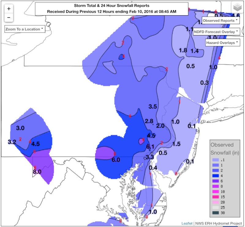
http://www.weather.gov/erh/hydromet
_________________
"In weather and in life, there's no winning and losing; there's only winning and learning."
WINTER 2012/2013 TOTALS 43.65"WINTER 2017/2018 TOTALS 62.85" WINTER 2022/2023 TOTALS 4.9"
WINTER 2013/2014 TOTALS 64.85"WINTER 2018/2019 TOTALS 14.25" WINTER 2023/2024 TOTALS 13.1"
WINTER 2014/2015 TOTALS 71.20"WINTER 2019/2020 TOTALS 6.35"
WINTER 2015/2016 TOTALS 35.00"WINTER 2020/2021 TOTALS 37.75"
WINTER 2016/2017 TOTALS 42.25"WINTER 2021/2022 TOTALS 31.65"
sroc4- Admin
- Posts : 8331
Reputation : 301
Join date : 2013-01-07
Location : Wading River, LI
Re: Feb 9th-10th IVT Update 2.0
![]() by Taffy Wed Feb 10, 2016 9:00 am
by Taffy Wed Feb 10, 2016 9:00 am

Taffy- Pro Enthusiast
- Posts : 530
Reputation : 19
Join date : 2013-10-06
Location : Hopkinton, MA
Re: Feb 9th-10th IVT Update 2.0
![]() by SNOW MAN Wed Feb 10, 2016 9:17 am
by SNOW MAN Wed Feb 10, 2016 9:17 am
Taffy wrote:Snow flurries are finished. I went outside gathered them up and made a snowcone.
You didn't have enough to make two so you could share with OTI friend.

SNOW MAN- Senior Enthusiast
- Posts : 1361
Reputation : 25
Join date : 2013-01-13
Age : 64
Location : Marshalls Creek Pa.
Re: Feb 9th-10th IVT Update 2.0
![]() by Teetghhuhnbhj Wed Feb 10, 2016 9:47 am
by Teetghhuhnbhj Wed Feb 10, 2016 9:47 am
Teetghhuhnbhj- Posts : 19
Reputation : 0
Join date : 2015-01-24
Location : Belmar, NJ
Re: Feb 9th-10th IVT Update 2.0
![]() by rb924119 Wed Feb 10, 2016 9:50 am
by rb924119 Wed Feb 10, 2016 9:50 am
sroc4 wrote:rb924119 wrote:Hey, does anybody know where I can find a good map for storm reports from this?? I want to self assess lol
http://www.weather.gov/erh/hydromet
Thanks Scott!!
Although it is still snowing over parts of the area, it would happen such that I busted in the areas that everybody on this board live in ahaha
Observations:
My second call:
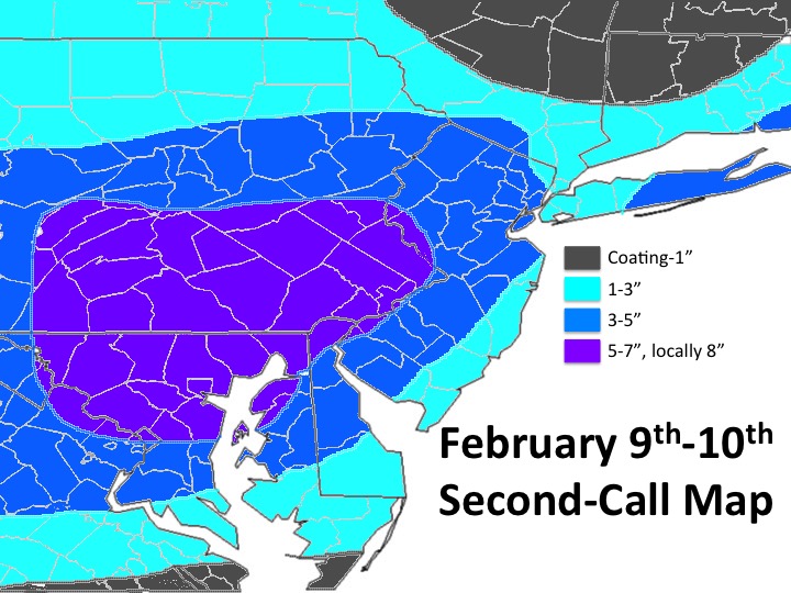
As you can see, my max area verified pretty well, and for the most part, all areas south of I-80 and west of the Delaware River verified pretty well. My 5-7" zone did expand a bit too far to the east it appears, but only by about 40 miles. The north-south extent was spot on, and it's hard to tell about the western periphery, but I'll give myself a fail for that, since I do have a closed contour and since the terrain doesn't vary significantly in the lacking regions of the observations (it's fairly mountainous), that is justifiable. With respect to this region, I'll give myself a threat-score of 80%. Where I got burned was the eastern extents of my 3-5" and 1-3" zones across New Jersey, Long Island, and southeastern Connecticut. My forecast was reliant on the coastal low developing, which in hindsight, we now know never happened. Had this developed, I think I would have verified a lot better, but seeing the current radar, it looks like Frank's general 1-3" will end up having verified for most members of this, and to him I tip my hat. Well done!! Seeing as though my 1-3" should have spanned from the Delaware River (roughly) to where it meets the 3-5" zone in New Jersey on my map, and my 1-3" zone there should have been a "Coating-1", all of Long Island should have been "Coating-1", Connecticut will likely meet the low end of my criteria save the 3-5" region in the extreme corner of the map, and that this busted for a majority of the members of this board, I will rate my threat score as a 25% for these regions. Keeping things mathematically simple, averaging these out I end up with a final threat-score of 52.5%, which is clearly an "F".
If this was a test in school, I'd be devastated; I won't lie. While this was a tough forecast, as this seems to be a trend in the last two seasons, I REFUSE to use that a cop-out. On the other hand, I am very happy that I spatially and fairly accurately pinpointed the highest impact zone with the greatest amounts. In the end, this comes down to serving as a learning experience, and I don't think only for me. That's the point of doing this; this isn't hating on myself, or being envious of Frank's better forecast. This is a platform for all to engage in constructively criticizing myself, because that's how you (I) learn. Honestly, I think that I've finally found a method of forecasting that I can use consistently in order to predict amounts, even though I got burned this time. I can be happy with that, and look forward to the next one so that I can better develop this new forecasting method. Live and learn, and track on dudes and dudettes!!!
rb924119- Meteorologist
- Posts : 6890
Reputation : 194
Join date : 2013-02-06
Age : 32
Location : Greentown, Pa
Re: Feb 9th-10th IVT Update 2.0
![]() by NjWeatherGuy Wed Feb 10, 2016 10:04 am
by NjWeatherGuy Wed Feb 10, 2016 10:04 am
syosnow94 wrote:A 3 day discussion about a threat that produced flurries.
What about the past 2 storms that dumped on you and scraped the rest of us with a few inches that melted after a couple hours with none at all the last one? My area and areas to my west and south have gotten several hours of snow in 3 rounds, the first one two nights ago with about 1" that melted pretty quickly. Round 2 last night with another thick coating and round 3 early this morning and continuing now with another 1" or so as of now combining the two. Driving last night around 12am road conditions actually became hazardous as it began to stick on treated roadways after heavy rates for a couple hours. Its not always about what happens in your backyard. I could have whined about the last 2 unmercifully but considering we had a historic blizzard in an unusually warm January and winter overall so far NOBODY should be complaining (besides NEPA and HV people well below avg as of now, cut them a pass on that one). NYC south exceeded seasonal snowfall already, Im around 35" now after this and theres nothing to be complainy about...
NjWeatherGuy- Advanced Forecaster
- Posts : 4100
Reputation : 28
Join date : 2013-01-06
Location : Belle Mead, NJ
Re: Feb 9th-10th IVT Update 2.0
![]() by CPcantmeasuresnow Wed Feb 10, 2016 10:25 am
by CPcantmeasuresnow Wed Feb 10, 2016 10:25 am
Just one mans opinion.
CPcantmeasuresnow- Wx Statistician Guru
- Posts : 7274
Reputation : 230
Join date : 2013-01-07
Age : 103
Location : Eastern Orange County, NY
Re: Feb 9th-10th IVT Update 2.0
![]() by NjWeatherGuy Wed Feb 10, 2016 10:31 am
by NjWeatherGuy Wed Feb 10, 2016 10:31 am
Not over yet CP. Bitter cold expected soon. Storm chances not done. I meant the complaints about this particular storm not affecting his LI backyard where the last 2 dumped him and gave the rest of us nothing.CPcantmeasuresnow wrote:Tom. The warmest meteorological winter in history so far. And 11 days below normal of the last 71. That's plenty to complain about in my book. It's what kind of winter you enjoy. I'll take near to below normal temperatures with average to slightly below average snowfall any day over this El Niño driven warm winter with one record breaking event any day and twice on Sunday. It's indvidual choice and even if I was at normal snowfall I would still loathe this winter for the relentless above normal temperatures.
Just one mans opinion.
NjWeatherGuy- Advanced Forecaster
- Posts : 4100
Reputation : 28
Join date : 2013-01-06
Location : Belle Mead, NJ
Re: Feb 9th-10th IVT Update 2.0
![]() by Guest Wed Feb 10, 2016 10:38 am
by Guest Wed Feb 10, 2016 10:38 am
NjWeatherGuy wrote:syosnow94 wrote:A 3 day discussion about a threat that produced flurries.
What about the past 2 storms that dumped on you and scraped the rest of us with a few inches that melted after a couple hours with none at all the last one? My area and areas to my west and south have gotten several hours of snow in 3 rounds, the first one two nights ago with about 1" that melted pretty quickly. Round 2 last night with another thick coating and round 3 early this morning and continuing now with another 1" or so as of now combining the two. Driving last night around 12am road conditions actually became hazardous as it began to stick on treated roadways after heavy rates for a couple hours. Its not always about what happens in your backyard. I could have whined about the last 2 unmercifully but considering we had a historic blizzard in an unusually warm January and winter overall so far NOBODY should be complaining (besides NEPA and HV people well below avg as of now, cut them a pass on that one). NYC south exceeded seasonal snowfall already, Im around 35" now after this and theres nothing to be complainy about...
READ THE POST I MADE DIRECTLY BELOW THE ONE YOU QUOTED AND IT WILL ANSWER YOUR QUESTION NJ!!!
Guest- Guest
Page 6 of 7 • 1, 2, 3, 4, 5, 6, 7 ![]()
|
|
|