
 Search
Feb 9th-10th IVT Update 2.0
Page 2 of 7 •  1, 2, 3, 4, 5, 6, 7
 ![]()
Re: Feb 9th-10th IVT Update 2.0
![]() by rb924119 Tue Feb 09, 2016 10:43 am
by rb924119 Tue Feb 09, 2016 10:43 am


 Good grieffffffff
rb924119- Meteorologist

- Posts : 6890
Join date : 2013-02-06
Re: Feb 9th-10th IVT Update 2.0
![]() by rb924119 Tue Feb 09, 2016 10:44 am
by rb924119 Tue Feb 09, 2016 10:44 am
syosnow94 wrote:Got ya. Quick question. The scroll at the top of the forum has Frank warning us of snow squalls this afternoon dropping a quick accumulation in spots. Is that independent of tonight's snows or all in the same?
I'd imagine they are the same.
rb924119- Meteorologist
- Posts : 6890
Join date : 2013-02-06
Re: Feb 9th-10th IVT Update 2.0
![]() by sroc4 Tue Feb 09, 2016 10:49 am
by sroc4 Tue Feb 09, 2016 10:49 am
rb924119 wrote:Now I'm looking at 12z runs and I'm not liking what I'm seeing ahaha
The fact that things are so volatile and diff from run to run is telling. There is no doubt there are multiple areas of subsidence with all these potential LP centers coming and going and what not, but I think reality is not like what models are showing right now. We shall see.
_________________
"In weather and in life, there's no winning and losing; there's only winning and learning."
WINTER 2012/2013 TOTALS 43.65"WINTER 2017/2018 TOTALS 62.85" WINTER 2022/2023 TOTALS 4.9"
WINTER 2013/2014 TOTALS 64.85"WINTER 2018/2019 TOTALS 14.25" WINTER 2023/2024 TOTALS 13.1"
WINTER 2014/2015 TOTALS 71.20"WINTER 2019/2020 TOTALS 6.35"
WINTER 2015/2016 TOTALS 35.00"WINTER 2020/2021 TOTALS 37.75"
WINTER 2016/2017 TOTALS 42.25"WINTER 2021/2022 TOTALS 31.65"

sroc4- Admin

- Posts : 8331
Reputation : 301
Join date : 2013-01-07
Location : Wading River, LI
Re: Feb 9th-10th IVT Update 2.0
![]() by Frank_Wx Tue Feb 09, 2016 10:53 am
by Frank_Wx Tue Feb 09, 2016 10:53 am
sroc4 wrote:Hey good morning. I have been busy in life's other areas to post much about the weather. Her is an update. Last week there were three waves I was looking at with the potential to deliver winter weather. Wave one occurred Friday and gave most of the area mod snowfall with Suffolk county being the jackpot recieving between 6-10" of the white gold.
Wave two was Early morning Monday into Monday night. I originally thought that this was going to end up well S and East of us and not affect the North East at all; however, as has been the trend this winter the hi resolution short range weather models trended back to the northwest with the final solution inside of 48-72hrs. Now normally a track that yesterdays system took would have missed our area completely; however, it was an absolute beast of a storm. It had a central pressure comparable to a Cat 1-2 hurricane. As a result it sent bands of precipitation hundreds of miles from its center into our area giving most if not all of Long Island measurable snowfall. Totals increased from west to east from a coating to an inch up to about 6-7 inches out on the south fork.
So what's the deal with the Tuesday system. Again last week I really thought this system would be the one to deliver a wide spread thumping to the tri state metropolitan area that could have delivered 6-12"+ type totals. That, unfort or fort depending on your preference, does not appear to be happening. I can still see where everyone gets at least a general light accumulation(1-3");however, on more of localized level more moderate accumulations are still possible between Tuesday and Thursday. Here is why.
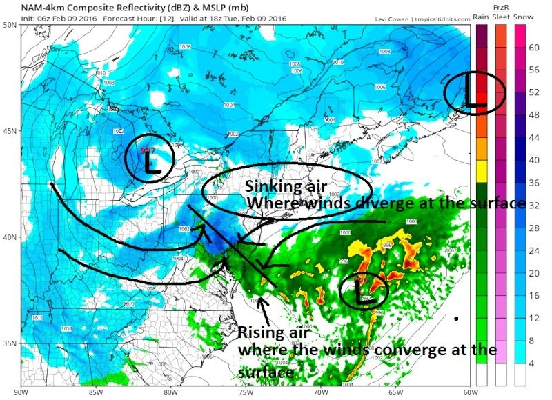
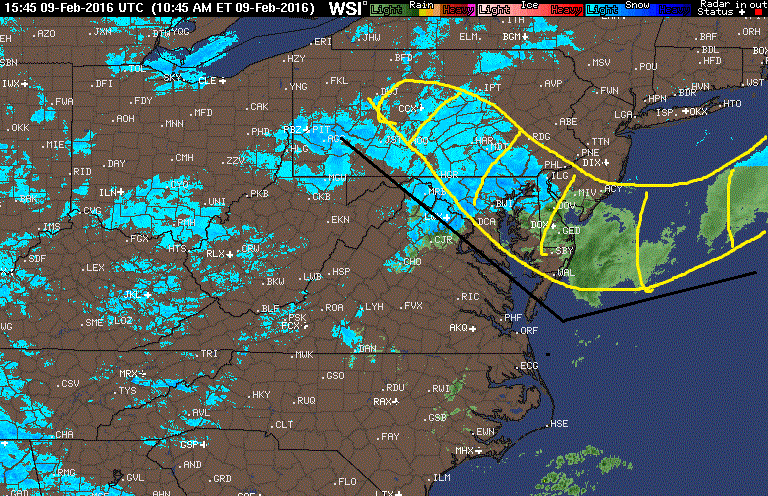
Lets refer to the first map below. The beast of a system that moved well to our south and east and is now pummeling Nova Scotia and the Canadian Maritime is simply too close to the second system which is currently centered east of Cape Hatteras NC. There are 3 surface LP centeres in relative close proximity. Notice in the image that the area in between all three low press centers there is no precip(blue circle). That is because air at the surface is moving away from that area towards all three of the surface LP centeres. This is termed divergence. When occuring at the surface the air that moves out of one location needs to be replaced. The air above it in the atmosphere sinks in these areas to achieve this. As we know sinking air (subsidence) IS NOT conducive to snowfall. In addition to being too close it is a tad too far west. If the original idea of well OTS and east occured it may have allowed room for this next system to head north up the coast inbetween the LP in the great lakes and the Monday beast. But because it, Mondays system, took a track a little further north and west closer to the coast, it is forcing this next system to track more east north east underneath it, instead of north strait up the coast in between. If you look at the upper levels you can see why this happens, but for simplicity and time I will not get into that any further.
Lets focus our attention back now on the LP centered over the great lakes and the one just off the NC coast. This was the set up I thought was going to give us the widespread significant snowfall. What is actually happening here? Well Sunday into Monday the LP moved into the great lakes and began to transfer energy to the coast re-developing a second low pressure center that exited the coast around the VA/NC coastline. The interaction between these two LP's and the energy swirling around in the upper levels that generated these LP's is whats going to lead to widespread light snowfall accumulations with localized mod to heavy accumulations.
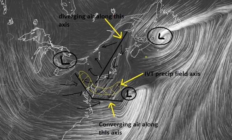
Below is a close up view of the map above. The development of a Norlun trough(named after the two meteorologists who first identified this feature) (aka Inverted trough(IVT)) is going to bring areas to our south localized mod-heavy snowfall. These things are really tough to predict exactly where they set up and even more difficult to predict how much snow will actually fall underneath them.
Simply stated...What happens is due to the counter clockwise winds around the two LP centers there develops an area of Convergence(air crashes into itself)) between the two LP centers when they are close enough to each other. Where this air comes together at the surface it is forced upward rapidly which leads to the formation of precipitation in a narrow band along this boundary. There is more to this but that is the general idea.
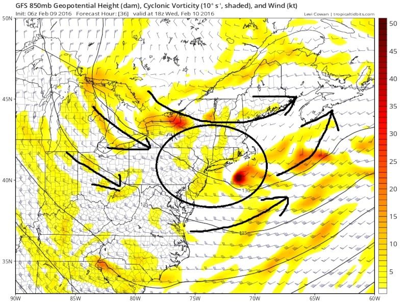
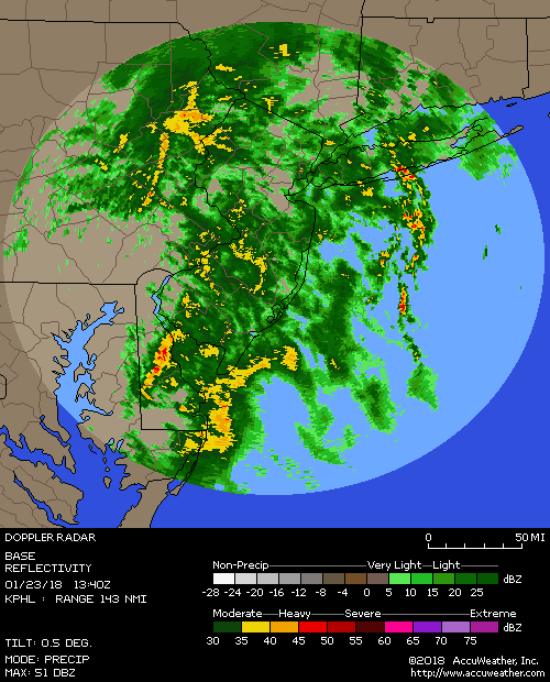
The main area, as you can see above, affected by the IVT for today is well to our south affecting DC area, Delmarva, and S NJ. However; it appears models are trying to develop a second LP center after the one from the image above moves out, somewhere south of long Island late tonight into Wed. The precipitation that develops from this is not as strait forward as a "traditional" coastal. This too is set up by the interactions between the newly formed LP south of LI and the LP that cont to move east through the Great Lakes to the north. Again an inverted trough axis tries to develop. There is also a lot of energy in the mid levels(yellows in the image below) that will rotate through and over this axis that could trigger mod to heavy snow bands that cannot be predicted until within a very short window.
So you have unstable air rotating through the region in the mid levels, a second LP center, and a potential second IVT axis(although not as well defined as the one today) that could lead to localized mod-heavy snow bands developing due to very unstable air. Again these types of set ups are extremely tough to forecast. So while I am calling for a generalized 1-3" for most of our area, if ones back yard were to be under one of these heavier bands, should they develop , could pick up 3-6" max additional snowfall between now and Thursday in addition to the general 1-3" Im predicting.


Agree. Very nice.
rb924119 wrote:Ok, so here's my second call:
This map was created using a blend of the models that I found to be best representing the current conditions of the atmosphere, with the analysis time remaining 12z today. A possible flaw in my analysis was that I primarily focussed on 00z suites, for two reasons. The first is that not all models run every six hours so using off-hour runs (I.E. 06z runs) would lead to an inconsistent analysis, and the second is that I prefer to use runs that ingest actual data. As such, I focused on two main levels; 500 hPa and the surface (largely because these are the only two levels that remain constant across all of the model data that I have access to). The best representations of those levels are as follows (in numerical order of accuracy):
1. CMC-GDPS - 500 hPa and surface were relatively accurate
2. UKMET - 500 hPa slightly off/precip relatively accurate
3. 03z SREF members (also in order): NMB2, NMB13, NMB10, NMB8 - 500 hPa, no good representation of surface features
4. RGEM, WRF-ARW, and Extended HRRR (24-hr) - precip only
Once I found my model base, I then weighted each to determine my amounts. The weighting was as follows:
1. 4x
2. 3x
3. 2x
4. 1x
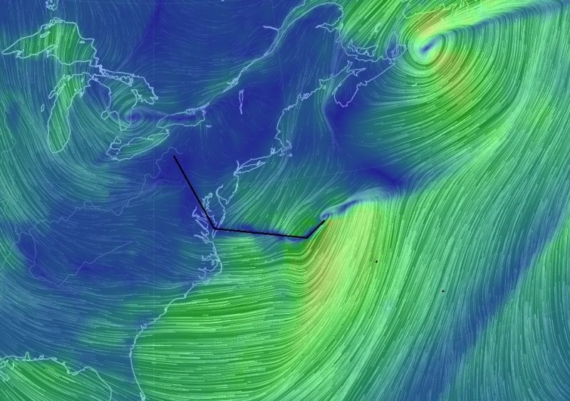
Now, current observations look to be on track so far with my thoughts, with regard to the levels of my analysis. The Norlun, while still convective in nature, as expected, looks healthy, which is a good sign. This should continue to hold together as the forcings at the mid-levels continue to come together. Something else of interest to me is this:
This image depicts surface pressure tendencies over the past hour, and if you loop through the last few hours you can actually see the Norlun holding itself together and progressing northward. The feature that most intrigues me, though, is the bullseye of pressure falls close to shore and inside of the BM. Will this continue into another weak closed low? The modeling I looked at suggests so, especially as we head into later this afternoon and evening. Unfortunately, all we can do is watch.


Nice analysis. 3-6" happens there's a coastal / IVT developing further north. If not, 1-3" for most and that's where I am leaning for now.
rb924119 wrote:syosnow94 wrote:Got ya. Quick question. The scroll at the top of the forum has Frank warning us of snow squalls this afternoon dropping a quick accumulation in spots. Is that independent of tonight's snows or all in the same?
I'd imagine they are the same.
Correct.
_________________
_______________________________________________________________________________________________________
CLICK HERE to view NJ Strong Snowstorm Classifications

Frank_Wx- Godzilla Seeker
- Posts : 21305
Reputation : 328
Join date : 2013-01-05
Age : 31
Location : Jersey City, NJ -

Re: Feb 9th-10th IVT Update 2.0
![]() by amugs Tue Feb 09, 2016 10:56 am
by amugs Tue Feb 09, 2016 10:56 am

_________________
Mugs
AKA:King: Snow Weenie
Self Proclaimed
WINTER 2014-15 : 55.12" +.02 for 6 coatings (avg. 35")
WINTER 2015-16 Total - 29.8" (Avg 35")
WINTER 2016-17 : 39.5" so far

amugs- Advanced Forecaster - Mod

- Posts : 15093
Reputation : 213
Join date : 2013-01-07
Age : 54
Location : Hillsdale,NJ
Re: Feb 9th-10th IVT Update 2.0
![]() by Guest Tue Feb 09, 2016 10:59 am
by Guest Tue Feb 09, 2016 10:59 am
amugs wrote:
LOOKS GOOD TO/FOR ME!!
Guest- Guest
Re: Feb 9th-10th IVT Update 2.0
![]() by sroc4 Tue Feb 09, 2016 11:14 am
by sroc4 Tue Feb 09, 2016 11:14 am
http://earth.nullschool.net/#current/wind/surface/level/overlay=off/orthographic=-72.11,40.73,2151/loc=-38.941,40.552
_________________
"In weather and in life, there's no winning and losing; there's only winning and learning."
WINTER 2012/2013 TOTALS 43.65"WINTER 2017/2018 TOTALS 62.85" WINTER 2022/2023 TOTALS 4.9"
WINTER 2013/2014 TOTALS 64.85"WINTER 2018/2019 TOTALS 14.25" WINTER 2023/2024 TOTALS 13.1"
WINTER 2014/2015 TOTALS 71.20"WINTER 2019/2020 TOTALS 6.35"
WINTER 2015/2016 TOTALS 35.00"WINTER 2020/2021 TOTALS 37.75"
WINTER 2016/2017 TOTALS 42.25"WINTER 2021/2022 TOTALS 31.65"
sroc4- Admin
- Posts : 8331
Reputation : 301
Join date : 2013-01-07
Location : Wading River, LI
Re: Feb 9th-10th IVT Update 2.0
![]() by sroc4 Tue Feb 09, 2016 11:44 am
by sroc4 Tue Feb 09, 2016 11:44 am
There will be people crying tears of joy from unexpected totals, and people crying tears of disgust because they barely got a trace. Be happy with 1-3". Be pleasantly surprised if you get more, and don't be surprised if you get less.
_________________
"In weather and in life, there's no winning and losing; there's only winning and learning."
WINTER 2012/2013 TOTALS 43.65"WINTER 2017/2018 TOTALS 62.85" WINTER 2022/2023 TOTALS 4.9"
WINTER 2013/2014 TOTALS 64.85"WINTER 2018/2019 TOTALS 14.25" WINTER 2023/2024 TOTALS 13.1"
WINTER 2014/2015 TOTALS 71.20"WINTER 2019/2020 TOTALS 6.35"
WINTER 2015/2016 TOTALS 35.00"WINTER 2020/2021 TOTALS 37.75"
WINTER 2016/2017 TOTALS 42.25"WINTER 2021/2022 TOTALS 31.65"
sroc4- Admin
- Posts : 8331
Reputation : 301
Join date : 2013-01-07
Location : Wading River, LI
Re: Feb 9th-10th IVT Update 2.0
![]() by mako460 Tue Feb 09, 2016 11:57 am
by mako460 Tue Feb 09, 2016 11:57 am
mako460- Pro Enthusiast

- Posts : 346
Reputation : 4
Join date : 2013-01-09
Age : 57
Location : Gerritsen Beach Brooklyn
Re: Feb 9th-10th IVT Update 2.0
![]() by oldtimer Tue Feb 09, 2016 12:14 pm
by oldtimer Tue Feb 09, 2016 12:14 pm
oldtimer- Senior Enthusiast

- Posts : 1103
Reputation : 14
Join date : 2013-01-16
Age : 78
Location : Port Jefferson Station Suffolk County
Re: Feb 9th-10th IVT Update 2.0
![]() by sroc4 Tue Feb 09, 2016 12:32 pm
by sroc4 Tue Feb 09, 2016 12:32 pm
mako460 wrote:Sroc, any idea when we can expect this to start, if it starts?
If I had to guess not until sometime after sun down.
_________________
"In weather and in life, there's no winning and losing; there's only winning and learning."
WINTER 2012/2013 TOTALS 43.65"WINTER 2017/2018 TOTALS 62.85" WINTER 2022/2023 TOTALS 4.9"
WINTER 2013/2014 TOTALS 64.85"WINTER 2018/2019 TOTALS 14.25" WINTER 2023/2024 TOTALS 13.1"
WINTER 2014/2015 TOTALS 71.20"WINTER 2019/2020 TOTALS 6.35"
WINTER 2015/2016 TOTALS 35.00"WINTER 2020/2021 TOTALS 37.75"
WINTER 2016/2017 TOTALS 42.25"WINTER 2021/2022 TOTALS 31.65"
sroc4- Admin
- Posts : 8331
Reputation : 301
Join date : 2013-01-07
Location : Wading River, LI
Re: Feb 9th-10th IVT Update 2.0
![]() by sroc4 Tue Feb 09, 2016 12:34 pm
by sroc4 Tue Feb 09, 2016 12:34 pm
sroc4 wrote:Honestly I think many are approaching models the wrong way with this set up. Too much model hugging and verbatim analysis. Look at the main mechanisms on how snowfall is to be produced here. We are not talking about a single LP either too far S and E or In too close N and W of the BM. This is a set up that relies on areas of subsidence vs convergence. There is no model out there, mesoscale or global, that can handle this type of set up accurately. The fact that an individual run shows 0.5"QPF vs 0.01"QPF is irrelevant. We need to focus on the fact that we have that range of QPF within all the modeling. This tells me that somone will prob over achieve, and others will underachieve. The fact that within any given model QPF amts for any given location has changed so drastically from run to run and model to model, should be the first clue that we wont know how it shakes out until its over.
There will be people crying tears of joy from unexpected totals, and people crying tears of disgust because they barely got a trace. Be happy with 1-3". Be pleasantly surprised if you get more, and don't be surprised if you get less.
Id like to actually edit this post. I didn't necessarily mean anyone on this board when I wrote: "Too much model hugging and verbatim analysis". I originally posted this in another board.
_________________
"In weather and in life, there's no winning and losing; there's only winning and learning."
WINTER 2012/2013 TOTALS 43.65"WINTER 2017/2018 TOTALS 62.85" WINTER 2022/2023 TOTALS 4.9"
WINTER 2013/2014 TOTALS 64.85"WINTER 2018/2019 TOTALS 14.25" WINTER 2023/2024 TOTALS 13.1"
WINTER 2014/2015 TOTALS 71.20"WINTER 2019/2020 TOTALS 6.35"
WINTER 2015/2016 TOTALS 35.00"WINTER 2020/2021 TOTALS 37.75"
WINTER 2016/2017 TOTALS 42.25"WINTER 2021/2022 TOTALS 31.65"
sroc4- Admin
- Posts : 8331
Reputation : 301
Join date : 2013-01-07
Location : Wading River, LI
Re: Feb 9th-10th IVT Update 2.0
![]() by NjWeatherGuy Tue Feb 09, 2016 12:46 pm
by NjWeatherGuy Tue Feb 09, 2016 12:46 pm

NjWeatherGuy- Advanced Forecaster

- Posts : 4100
Reputation : 28
Join date : 2013-01-06
Location : Belle Mead, NJ
Re: Feb 9th-10th IVT Update 2.0
![]() by Math23x7 Tue Feb 09, 2016 12:50 pm
by Math23x7 Tue Feb 09, 2016 12:50 pm
Math23x7- Wx Statistician Guru

- Posts : 2379
Reputation : 68
Join date : 2013-01-08
Re: Feb 9th-10th IVT Update 2.0
![]() by NjWeatherGuy Tue Feb 09, 2016 1:09 pm
by NjWeatherGuy Tue Feb 09, 2016 1:09 pm
I think so,Math23x7 wrote:Tom was this the February 14th to 15th system last year?
https://www.njstrongweatherforum.com/t478-feb-14th-15th-storm-thread-observations-and-discussions
Funny our comments are basically exactly the same
NjWeatherGuy- Advanced Forecaster
- Posts : 4100
Reputation : 28
Join date : 2013-01-06
Location : Belle Mead, NJ
Re: Feb 9th-10th IVT Update 2.0
![]() by Guest Tue Feb 09, 2016 1:09 pm
by Guest Tue Feb 09, 2016 1:09 pm
Guest- Guest
NjWeatherGuy- Advanced Forecaster
- Posts : 4100
Reputation : 28
Join date : 2013-01-06
Location : Belle Mead, NJ
Re: Feb 9th-10th IVT Update 2.0
![]() by amugs Tue Feb 09, 2016 2:42 pm
by amugs Tue Feb 09, 2016 2:42 pm
sroc4 wrote:sroc4 wrote:Honestly I think many are approaching models the wrong way with this set up. Too much model hugging and verbatim analysis. Look at the main mechanisms on how snowfall is to be produced here. We are not talking about a single LP either too far S and E or In too close N and W of the BM. This is a set up that relies on areas of subsidence vs convergence. There is no model out there, mesoscale or global, that can handle this type of set up accurately. The fact that an individual run shows 0.5"QPF vs 0.01"QPF is irrelevant. We need to focus on the fact that we have that range of QPF within all the modeling. This tells me that somone will prob over achieve, and others will underachieve. The fact that within any given model QPF amts for any given location has changed so drastically from run to run and model to model, should be the first clue that we wont know how it shakes out until its over.
There will be people crying tears of joy from unexpected totals, and people crying tears of disgust because they barely got a trace. Be happy with 1-3". Be pleasantly surprised if you get more, and don't be surprised if you get less.
Id like to actually edit this post. I didn't necessarily mean anyone on this board when I wrote: "Too much model hugging and verbatim analysis". I originally posted this in another board.
I hug a model everyday and sleep with one every night - easy Jimbo - MY WIFE!! Yes she was a model in her day, mid to late 80's!! So I must confess that I love hugging models both weather and real ones!!
_________________
Mugs
AKA:King: Snow Weenie
Self Proclaimed
WINTER 2014-15 : 55.12" +.02 for 6 coatings (avg. 35")
WINTER 2015-16 Total - 29.8" (Avg 35")
WINTER 2016-17 : 39.5" so far
amugs- Advanced Forecaster - Mod
- Posts : 15093
Reputation : 213
Join date : 2013-01-07
Age : 54
Location : Hillsdale,NJ
Re: Feb 9th-10th IVT Update 2.0
![]() by amugs Tue Feb 09, 2016 2:43 pm
by amugs Tue Feb 09, 2016 2:43 pm
NjWeatherGuy wrote:Flakes just started flying
Jackpot zone you are in once again!!
_________________
Mugs
AKA:King: Snow Weenie
Self Proclaimed
WINTER 2014-15 : 55.12" +.02 for 6 coatings (avg. 35")
WINTER 2015-16 Total - 29.8" (Avg 35")
WINTER 2016-17 : 39.5" so far
amugs- Advanced Forecaster - Mod
- Posts : 15093
Reputation : 213
Join date : 2013-01-07
Age : 54
Location : Hillsdale,NJ
oldtimer- Senior Enthusiast
- Posts : 1103
Reputation : 14
Join date : 2013-01-16
Age : 78
Location : Port Jefferson Station Suffolk County
Re: Feb 9th-10th IVT Update 2.0
![]() by frank 638 Tue Feb 09, 2016 2:57 pm
by frank 638 Tue Feb 09, 2016 2:57 pm
frank 638- Senior Enthusiast
- Posts : 2825
Reputation : 37
Join date : 2016-01-01
Age : 40
Location : bronx ny
Re: Feb 9th-10th IVT Update 2.0
![]() by weatherwatchermom Tue Feb 09, 2016 3:15 pm
by weatherwatchermom Tue Feb 09, 2016 3:15 pm

weatherwatchermom- Senior Enthusiast
- Posts : 3750
Reputation : 77
Join date : 2014-11-25
Age : 60
Location : Hazlet Township, NJ
Re: Feb 9th-10th IVT Update 2.0
![]() by Guest Tue Feb 09, 2016 3:19 pm
by Guest Tue Feb 09, 2016 3:19 pm
Guest- Guest
U know how u feel I was excited with all the snow coming this week and all I got is a coating wow
![]() by frank 638 Tue Feb 09, 2016 3:19 pm
by frank 638 Tue Feb 09, 2016 3:19 pm

weatherwatchermom wrote:cold...32* sun just came out.and a few flakes are falling...this week is just a disappointment for snow..
frank 638- Senior Enthusiast
- Posts : 2825
Reputation : 37
Join date : 2016-01-01
Age : 40
Location : bronx ny
Re: Feb 9th-10th IVT Update 2.0
![]() by sroc4 Tue Feb 09, 2016 3:23 pm
by sroc4 Tue Feb 09, 2016 3:23 pm
amugs wrote:sroc4 wrote:sroc4 wrote:Honestly I think many are approaching models the wrong way with this set up. Too much model hugging and verbatim analysis. Look at the main mechanisms on how snowfall is to be produced here. We are not talking about a single LP either too far S and E or In too close N and W of the BM. This is a set up that relies on areas of subsidence vs convergence. There is no model out there, mesoscale or global, that can handle this type of set up accurately. The fact that an individual run shows 0.5"QPF vs 0.01"QPF is irrelevant. We need to focus on the fact that we have that range of QPF within all the modeling. This tells me that somone will prob over achieve, and others will underachieve. The fact that within any given model QPF amts for any given location has changed so drastically from run to run and model to model, should be the first clue that we wont know how it shakes out until its over.
There will be people crying tears of joy from unexpected totals, and people crying tears of disgust because they barely got a trace. Be happy with 1-3". Be pleasantly surprised if you get more, and don't be surprised if you get less.
Id like to actually edit this post. I didn't necessarily mean anyone on this board when I wrote: "Too much model hugging and verbatim analysis". I originally posted this in another board.
I hug a model everyday and sleep with one every night - easy Jimbo - MY WIFE!! Yes she was a model in her day, mid to late 80's!! So I must confess that I love hugging models both weather and real ones!!


Yes!! Perfect response. Lol
_________________
"In weather and in life, there's no winning and losing; there's only winning and learning."
WINTER 2012/2013 TOTALS 43.65"WINTER 2017/2018 TOTALS 62.85" WINTER 2022/2023 TOTALS 4.9"
WINTER 2013/2014 TOTALS 64.85"WINTER 2018/2019 TOTALS 14.25" WINTER 2023/2024 TOTALS 13.1"
WINTER 2014/2015 TOTALS 71.20"WINTER 2019/2020 TOTALS 6.35"
WINTER 2015/2016 TOTALS 35.00"WINTER 2020/2021 TOTALS 37.75"
WINTER 2016/2017 TOTALS 42.25"WINTER 2021/2022 TOTALS 31.65"
sroc4- Admin
- Posts : 8331
Reputation : 301
Join date : 2013-01-07
Location : Wading River, LI
Re: Feb 9th-10th IVT Update 2.0
![]() by SNOW MAN Tue Feb 09, 2016 3:38 pm
by SNOW MAN Tue Feb 09, 2016 3:38 pm
weatherwatchermom wrote:cold...32* sun just came out.and a few flakes are falling...this week is just a disappointment for snow..
I couldn't agree with you more.

SNOW MAN- Senior Enthusiast
- Posts : 1361
Reputation : 25
Join date : 2013-01-13
Age : 64
Location : Marshalls Creek Pa.

snow247- Pro Enthusiast
- Posts : 2417
Reputation : 0
Join date : 2014-08-27
Location : Mount Ivy, NY - Elevation 545'
Page 2 of 7 • 1, 2, 3, 4, 5, 6, 7 ![]()
|
|
|