
 Search
2016 Tropical Cyclone Discussions
Page 11 of 33 •  1 ... 7 ... 10, 11, 12 ... 22 ... 33
 ![]()
Re: 2016 Tropical Cyclone Discussions
![]() by jmanley32 Wed Aug 24, 2016 1:13 pm
by jmanley32 Wed Aug 24, 2016 1:13 pm
Snow88 wrote:Ukie is more east and weaker on the `12z run
Could Gaston play a roll?
Gaston was much further west on runs, but I don't believe he will get to Bermuda west or even further, but that could def keep 99L going more west or maybe even a bit North. And that ridge, seems to be changing on its intensity from run to run. Def complex setup here and zeroing in on 5 days or less not a whole lot of time, this could well pull a fast on on the US, or not.
jmanley32- Senior Enthusiast

- Posts : 20513
Join date : 2013-12-12
Re: 2016 Tropical Cyclone Discussions
![]() by jmanley32 Wed Aug 24, 2016 1:17 pm
by jmanley32 Wed Aug 24, 2016 1:17 pm
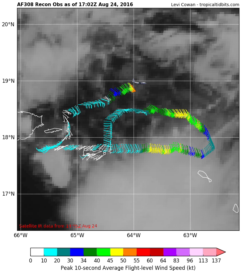
Recon mission so far, def plenty TS winds.
jmanley32- Senior Enthusiast
- Posts : 20513
Join date : 2013-12-12
Re: 2016 Tropical Cyclone Discussions
![]() by jmanley32 Wed Aug 24, 2016 1:18 pm
by jmanley32 Wed Aug 24, 2016 1:18 pm

jmanley32- Senior Enthusiast
- Posts : 20513
Reputation : 108
Join date : 2013-12-12
Age : 42
Location : Yonkers, NY
Re: 2016 Tropical Cyclone Discussions
![]() by Snow88 Wed Aug 24, 2016 1:39 pm
by Snow88 Wed Aug 24, 2016 1:39 pm

Snow88- Senior Enthusiast
- Posts : 2193
Reputation : 4
Join date : 2013-01-09
Age : 35
Location : Brooklyn, NY
Re: 2016 Tropical Cyclone Discussions
![]() by rb924119 Wed Aug 24, 2016 2:02 pm
by rb924119 Wed Aug 24, 2016 2:02 pm
Snow88 wrote:Ukie is more east and weaker on the `12z run
Could Gaston play a roll?
This is my very unprofessional opinion, as tropics are not something that I enjoy nor have much practice at, BUT Gaston COULD be playing a role here. I think it was last year, when we were looking at the brief possibility of a Sandy repeat (don't quote me on the year, though; Sroc might remember) with a similar set-up -- a hurricane well out in the middle of nowhere with another one developing closer inshore as a digging trough was entering the eastern CONUS. It was during this discussion that the analogy of a bowling ball and golf ball both on a mattress was used. IF Gaston can become strong enough (i.e. lower pressure), then it might be close enough "tug" a little bit on 99L with respect to the surface pressure fields. Pressures, if able, like to consolidate when they're lower. I think the actual discussion is archived in the Education thread.
This is one component. The other component, as it was mentioned earlier but I forget by whom, is how quickly the broad mid-level ridge can break apart. This is because if 99L is able to strengthen, it will start to become steered NOT by the lower-level easterlies, but the winds above it. If Gaston strengthens quickly enough so that it splits the elongated ridge, this will pave the way for 99L to be steered by other mechanisms such as Beta-drift and Gaston's "tugging", as well as to be able to start repositioning the ridge in the Southeast to its northeast via diabatic processes, because no other large-scale factors will be present. That would favor a more eastern track.
My own thoughts are that 99L strengthens much sooner than currently modeled, since there won't be much to deter this. In fact, conditions look pretty good to me for it to intensify fairly quickly provided that it stays over water. With a further south placement, this is the only worry, as the recurve would likely bring it at least partially over the mainland islands and disrupt the developmental processes. If it does stay over water, and it does strengthen, I think an East Coast solution becomes very plausible. Now I don't mean a direct hit per se, but something like a parallel within 500 miles of the coast is something that I have felt from the beginning. However, recent guidance has trended the other way. A worry outside of the control of the tropics, is the large-scale Northern Hemispheric setup, which favors the Southeast ridge to hold its ground and direct 99L west into the Gulf. This will be an interesting tug of war, I think.
I also think that because there is no "organized" and "focused" low-level circulation, the models are having a very tough time initializing it's intensity and placement, which in turn ultimately largely affect the solutions we see. This is common, however.
Last edited by rb924119 on Wed Aug 24, 2016 2:16 pm; edited 2 times in total
rb924119- Meteorologist

- Posts : 6889
Reputation : 194
Join date : 2013-02-06
Age : 32
Location : Greentown, Pa
Re: 2016 Tropical Cyclone Discussions
![]() by nutleyblizzard Wed Aug 24, 2016 2:08 pm
by nutleyblizzard Wed Aug 24, 2016 2:08 pm
As long as they found a closed area of low pressure, technically they should classify it as a tropical storm at 5pm. They probably won't though with the lack of convection currently around the center.jmanley32 wrote:I just updated the recon found a decent area of 50-65kt winds!!

nutleyblizzard- Senior Enthusiast
- Posts : 1952
Reputation : 41
Join date : 2014-01-30
Age : 58
Location : Nutley, new jersey
Re: 2016 Tropical Cyclone Discussions
![]() by rb924119 Wed Aug 24, 2016 2:08 pm
by rb924119 Wed Aug 24, 2016 2:08 pm
sroc4 wrote:Honestly the biggest difference between the Euro and the GFS regarding intensity is the amount of dry air ingested by the system at various points. The current observations up through this point have not supported the GFS soln IMO. When the vorticity makes it into the Bahamas hr 84 followed by hr 132. The dryer air is held much further north on the Euro vs the GFS which makes all the difference.
Regarding track with the consistency in the modeling regarding the weakness in the ridge over the Rockies and positioning of the ridge off the EC a more westward track into the GOM under the ridge without question seems more likely to me vs the quickly recurving soln and re-emergence of the EC the 00z GFS showed last night.


GFS PROGRESSIVE BIAS!!! Follow that dry air back to its source; part of it is from a front that passes through our area later this week. EURO doesn't do that, which makes sense given the diabatic component of tropical convection to the northeast of the system convecting (in this case 99L). This is also the reason that when we had all of that hot and humid weather last week the front never made it through for days. All of the convection in the Gulf and Southeast kept feeding into the ridge.
rb924119- Meteorologist
- Posts : 6889
Reputation : 194
Join date : 2013-02-06
Age : 32
Location : Greentown, Pa
Re: 2016 Tropical Cyclone Discussions
![]() by Snow88 Wed Aug 24, 2016 2:30 pm
by Snow88 Wed Aug 24, 2016 2:30 pm
Pounds the west coast of Florida and stalls there
Snow88- Senior Enthusiast
- Posts : 2193
Reputation : 4
Join date : 2013-01-09
Age : 35
Location : Brooklyn, NY
Re: 2016 Tropical Cyclone Discussions
![]() by sroc4 Wed Aug 24, 2016 2:39 pm
by sroc4 Wed Aug 24, 2016 2:39 pm
rb924119 wrote:Snow88 wrote:Ukie is more east and weaker on the `12z run
Could Gaston play a roll?
This is my very unprofessional opinion, as tropics are not something that I enjoy nor have much practice at, BUT Gaston COULD be playing a role here. I think it was last year, when we were looking at the brief possibility of a Sandy repeat (don't quote me on the year, though; Sroc might remember) with a similar set-up -- a hurricane well out in the middle of nowhere with another one developing closer inshore as a digging trough was entering the eastern CONUS. It was during this discussion that the analogy of a bowling ball and golf ball both on a mattress was used. IF Gaston can become strong enough (i.e. lower pressure), then it might be close enough "tug" a little bit on 99L with respect to the surface pressure fields. Pressures, if able, like to consolidate when they're lower. I think the actual discussion is archived in the Education thread.
This is one component. The other component, as it was mentioned earlier but I forget by whom, is how quickly the broad mid-level ridge can break apart, with one center remaining northeast of Gaston, and the other consolidating over the Rockies. This is because if 99L is able to strengthen, it will start to become steered NOT by the lower-level easterlies, but the winds above it. If Gaston strengthens quickly enough so that it splits the elongated ridge and essentially allows climatological placement of the western ridge to take over sooner, this will pave the way for 99L to be steered by other mechanisms such as Beta-drift and Gaston's "tugging", because no other large-scale factors will be present.
My own thoughts are that 99L strengthens much sooner than currently modeled, since there won't be much to deter this. In fact, conditions look pretty good to me for it to intensify fairly quickly provided that it stays over water. With a further south placement, this is the only worry, as the recurve would likely bring it at least partially over the mainland islands and disrupt the developmental processes. If it does stay over water, and it does strengthen, I think an East Coast solution becomes very plausible. Now I don't mean a direct hit per se, but something like a parallel within 500 miles of the coast is something that I have felt from the beginning. However, recent guidance has trended the other way.
I also think that because there is no "organized" and "focused" low-level circulation, the models are having a very tough time initializing it's intensity and placement, which in turn ultimately largely affect the solutions we see. This is common, however.
Rb whats up brother? I 100% agree with you regarding the lack of closed LLC and the modeling esp regarding the GFS. You can see right now the center of circulation is "naked" or devoid of convection and currently is being distrupted buy PR.


That said I think a new LLC is going to reform N of where you see the black line as it heads westward. Notice the nice organized convection from earlier this morning is weakening and sinking S where as we have new convection beginning to fie out ahead and north. Could get interesting by the time we awake in the am.

Euro should be out soon. Tonights 00z runs will have the most recent recon data in it I believe. Bottom line is we have to see a better surface center before we see the truth. That said if the LLC conts to interact with Land it will cont to struggle to devlop. Shear cont on the north side too.
Rb it was hurricane Joaquin and here is the link to the discussion. https://www.njstrongweatherforum.com/t585-a-discussion-on-the-track-of-major-hurricane-joaquin-oct-2nd-2015
I do not believe Gaston plays the same role; however, in this system. That said if it ramps up rapidly and is far enough north it could feel the crease created in the Atlantic ridge by Gaston and recurve into the EC below SC latitude.
_________________
"In weather and in life, there's no winning and losing; there's only winning and learning."
WINTER 2012/2013 TOTALS 43.65"WINTER 2017/2018 TOTALS 62.85" WINTER 2022/2023 TOTALS 4.9"
WINTER 2013/2014 TOTALS 64.85"WINTER 2018/2019 TOTALS 14.25" WINTER 2023/2024 TOTALS 13.1"
WINTER 2014/2015 TOTALS 71.20"WINTER 2019/2020 TOTALS 6.35"
WINTER 2015/2016 TOTALS 35.00"WINTER 2020/2021 TOTALS 37.75"
WINTER 2016/2017 TOTALS 42.25"WINTER 2021/2022 TOTALS 31.65"

sroc4- Admin

- Posts : 8331
Reputation : 301
Join date : 2013-01-07
Location : Wading River, LI
Re: 2016 Tropical Cyclone Discussions
![]() by sroc4 Wed Aug 24, 2016 2:44 pm
by sroc4 Wed Aug 24, 2016 2:44 pm

_________________
"In weather and in life, there's no winning and losing; there's only winning and learning."
WINTER 2012/2013 TOTALS 43.65"WINTER 2017/2018 TOTALS 62.85" WINTER 2022/2023 TOTALS 4.9"
WINTER 2013/2014 TOTALS 64.85"WINTER 2018/2019 TOTALS 14.25" WINTER 2023/2024 TOTALS 13.1"
WINTER 2014/2015 TOTALS 71.20"WINTER 2019/2020 TOTALS 6.35"
WINTER 2015/2016 TOTALS 35.00"WINTER 2020/2021 TOTALS 37.75"
WINTER 2016/2017 TOTALS 42.25"WINTER 2021/2022 TOTALS 31.65"
sroc4- Admin
- Posts : 8331
Reputation : 301
Join date : 2013-01-07
Location : Wading River, LI
Re: 2016 Tropical Cyclone Discussions
![]() by jmanley32 Wed Aug 24, 2016 2:55 pm
by jmanley32 Wed Aug 24, 2016 2:55 pm
jmanley32- Senior Enthusiast
- Posts : 20513
Reputation : 108
Join date : 2013-12-12
Age : 42
Location : Yonkers, NY
Re: 2016 Tropical Cyclone Discussions
![]() by jmanley32 Wed Aug 24, 2016 3:00 pm
by jmanley32 Wed Aug 24, 2016 3:00 pm
jmanley32- Senior Enthusiast
- Posts : 20513
Reputation : 108
Join date : 2013-12-12
Age : 42
Location : Yonkers, NY
Re: 2016 Tropical Cyclone Discussions
![]() by rb924119 Wed Aug 24, 2016 3:01 pm
by rb924119 Wed Aug 24, 2016 3:01 pm
sroc4 wrote:rb924119 wrote:Snow88 wrote:Ukie is more east and weaker on the `12z run
Could Gaston play a roll?
This is my very unprofessional opinion, as tropics are not something that I enjoy nor have much practice at, BUT Gaston COULD be playing a role here. I think it was last year, when we were looking at the brief possibility of a Sandy repeat (don't quote me on the year, though; Sroc might remember) with a similar set-up -- a hurricane well out in the middle of nowhere with another one developing closer inshore as a digging trough was entering the eastern CONUS. It was during this discussion that the analogy of a bowling ball and golf ball both on a mattress was used. IF Gaston can become strong enough (i.e. lower pressure), then it might be close enough "tug" a little bit on 99L with respect to the surface pressure fields. Pressures, if able, like to consolidate when they're lower. I think the actual discussion is archived in the Education thread.
This is one component. The other component, as it was mentioned earlier but I forget by whom, is how quickly the broad mid-level ridge can break apart, with one center remaining northeast of Gaston, and the other consolidating over the Rockies. This is because if 99L is able to strengthen, it will start to become steered NOT by the lower-level easterlies, but the winds above it. If Gaston strengthens quickly enough so that it splits the elongated ridge and essentially allows climatological placement of the western ridge to take over sooner, this will pave the way for 99L to be steered by other mechanisms such as Beta-drift and Gaston's "tugging", because no other large-scale factors will be present.
My own thoughts are that 99L strengthens much sooner than currently modeled, since there won't be much to deter this. In fact, conditions look pretty good to me for it to intensify fairly quickly provided that it stays over water. With a further south placement, this is the only worry, as the recurve would likely bring it at least partially over the mainland islands and disrupt the developmental processes. If it does stay over water, and it does strengthen, I think an East Coast solution becomes very plausible. Now I don't mean a direct hit per se, but something like a parallel within 500 miles of the coast is something that I have felt from the beginning. However, recent guidance has trended the other way.
I also think that because there is no "organized" and "focused" low-level circulation, the models are having a very tough time initializing it's intensity and placement, which in turn ultimately largely affect the solutions we see. This is common, however.
Rb whats up brother? I 100% agree with you regarding the lack of closed LLC and the modeling esp regarding the GFS. You can see right now the center of circulation is "naked" or devoid of convection and currently is being distrupted buy PR.
That said I think a new LLC is going to reform N of where you see the black line as it heads westward. Notice the nice organized convection from earlier this morning is weakening and sinking S where as we have new convection beginning to fie out ahead and north. Could get interesting by the time we awake in the am.
Euro should be out soon. Tonights 00z runs will have the most recent recon data in it I believe. Bottom line is we have to see a better surface center before we see the truth. That said if the LLC conts to interact with Land it will cont to struggle to devlop. Shear cont on the north side too.
Rb it was hurricane Joaquin and here is the link to the discussion. https://www.njstrongweatherforum.com/t585-a-discussion-on-the-track-of-major-hurricane-joaquin-oct-2nd-2015
I do not believe Gaston plays the same role; however, in this system. That said if it ramps up rapidly and is far enough north it could feel the crease created in the Atlantic ridge by Gaston and recurve into the EC below SC latitude.
Haha not much my friend. Wishing this soon-to-feel endless summer would just up and leave lmao hope you're well!!
To your thought of a new LLC, I would tend to disagree with that. To me, and I may need glasses, it looks like there is a decent circulation developing underneath that burst of convection from this morning, and I think that's where we will see it continue to develop. Even though that convection is dying down, tropical convection has a very large nocturnal component to it, where it flares at night and then dies off during the day. I think tomorrow morning we will see something that is very close to what we saw this morning, which will allow continued slow but steady consolidation. Definitely agree with you in that if it continues over the land, especially those islands which are incredibly mountainous, it will have a very hard time. I WAS GONNA SAY JOAQUIN, TOO!!! DARN IT!!! haha
 Lastly, you may be right about Gaston; it may be too far removed for it to play a role at the surface, but I definitely think it will work to favorably alter the mid-levels.
rb924119- Meteorologist
- Posts : 6889
Reputation : 194
Join date : 2013-02-06
Age : 32
Location : Greentown, Pa
Re: 2016 Tropical Cyclone Discussions
![]() by rb924119 Wed Aug 24, 2016 3:05 pm
by rb924119 Wed Aug 24, 2016 3:05 pm
jmanley32 wrote:If this goes up ec and off by Carolinas is it Def ots or could it still threaten the area? I'm guessing too soon to know being that's near 10 days away but a guess by any of you.
I would say that chances would be very slim for it to recurve to the west and impact us. Once it's feeling that much of a westerly wind component, I don't think there could be a trough deep enough, especially this time of year, to swing it THAT far back to the west. High surf and rip currents will still be an issue, though; especially for south-facing shorelines. Latest EURO definitely more in line with what I'm thinking, although I still feel it's too far west. I can't believe I'm saying this, but the NAM actually looks most reasonable to my train of thought. Might be a little too far northeast, but certainly is closer than even what the latest EURO does with it, in my opinion.
rb924119- Meteorologist
- Posts : 6889
Reputation : 194
Join date : 2013-02-06
Age : 32
Location : Greentown, Pa
Re: 2016 Tropical Cyclone Discussions
![]() by amugs Wed Aug 24, 2016 3:12 pm
by amugs Wed Aug 24, 2016 3:12 pm
August 24 02:57 PM
1) It has tropical storm winds already and a low level circulation is on the cloud shot
2) ITS MID LEVEL CIRCULATION IS LEFT BEHIND TO THE SOUTHEAST. This is clearing a huge inhibiting factor meaning there in spite of the appearance in the High winds of an anticyclone, the system is like someone that through out their back... Not aligned right, perhaps because of the fast movement
3) The Euro hugging the FLA coast is the obvious reason for the weaker gulf result. I have no idea why its up to that even though it weakens the ridge, but a) it should get further west b) takes a path now that has less land before the gulf but quickly turns it up the coast after. So pressures only get to 985 as that track is not a favorable track for intensification . The 1935 hurricane weakened from a cat 5 to 1 trying that
The call is no change for now... If the GFS is right it will be the greatest coup I have ever seen in its tropical performance
_________________
Mugs
AKA:King: Snow Weenie
Self Proclaimed
WINTER 2014-15 : 55.12" +.02 for 6 coatings (avg. 35")
WINTER 2015-16 Total - 29.8" (Avg 35")
WINTER 2016-17 : 39.5" so far

amugs- Advanced Forecaster - Mod

- Posts : 15093
Reputation : 213
Join date : 2013-01-07
Age : 54
Location : Hillsdale,NJ
Re: 2016 Tropical Cyclone Discussions
![]() by sroc4 Wed Aug 24, 2016 3:27 pm
by sroc4 Wed Aug 24, 2016 3:27 pm

There also may be a second center between Hispanola and PR just to the north
_________________
"In weather and in life, there's no winning and losing; there's only winning and learning."
WINTER 2012/2013 TOTALS 43.65"WINTER 2017/2018 TOTALS 62.85" WINTER 2022/2023 TOTALS 4.9"
WINTER 2013/2014 TOTALS 64.85"WINTER 2018/2019 TOTALS 14.25" WINTER 2023/2024 TOTALS 13.1"
WINTER 2014/2015 TOTALS 71.20"WINTER 2019/2020 TOTALS 6.35"
WINTER 2015/2016 TOTALS 35.00"WINTER 2020/2021 TOTALS 37.75"
WINTER 2016/2017 TOTALS 42.25"WINTER 2021/2022 TOTALS 31.65"
sroc4- Admin
- Posts : 8331
Reputation : 301
Join date : 2013-01-07
Location : Wading River, LI
Re: 2016 Tropical Cyclone Discussions
![]() by jmanley32 Wed Aug 24, 2016 3:36 pm
by jmanley32 Wed Aug 24, 2016 3:36 pm
jmanley32- Senior Enthusiast
- Posts : 20513
Reputation : 108
Join date : 2013-12-12
Age : 42
Location : Yonkers, NY
Re: 2016 Tropical Cyclone Discussions
![]() by rb924119 Wed Aug 24, 2016 3:38 pm
by rb924119 Wed Aug 24, 2016 3:38 pm
sroc4 wrote:Rb. check out the low level cloud movement on the loop. I outlined where I think a LLC is trying to become more defined(black circle). The blue line is the area I want you to watch for the circulation on the loop. I could be wrong.
There also may be a second center between Hispanola and PR just to the north
Ahhh I see what you're saying now. That's a much better view of it compared to the infrared. You could be wrong, but you also could just as well be right. There is definitely an organized low-level rotation there, but as mugs posted above from JB, it's disjointed which is not conducive for development. We'll have to see if the mid-level swirl can relocate and orient itself over that low-level swirl. And to be honest, I the only way we will see that is if convection can be maintained over that low-level circulation. Otherwise, it will continue to be disorganized.
rb924119- Meteorologist
- Posts : 6889
Reputation : 194
Join date : 2013-02-06
Age : 32
Location : Greentown, Pa
Re: 2016 Tropical Cyclone Discussions
![]() by Frank_Wx Wed Aug 24, 2016 5:53 pm
by Frank_Wx Wed Aug 24, 2016 5:53 pm

_________________
_______________________________________________________________________________________________________
CLICK HERE to view NJ Strong Snowstorm Classifications

Frank_Wx- Godzilla Seeker
- Posts : 21305
Reputation : 328
Join date : 2013-01-05
Age : 31
Location : Jersey City, NJ -

Re: 2016 Tropical Cyclone Discussions
![]() by Frank_Wx Wed Aug 24, 2016 5:56 pm
by Frank_Wx Wed Aug 24, 2016 5:56 pm
sroc4 wrote:Rb. check out the low level cloud movement on the loop. I outlined where I think a LLC is trying to become more defined(black circle). The blue line is the area I want you to watch for the circulation on the loop. I could be wrong.
There also may be a second center between Hispanola and PR just to the north
It's annoying to see the LLC's not vertically stacked. Models can't decipher where the center is and it's wrecking havoc. Until the vort max becomes better defined on the models we'll continue to see varying solutions.
Also, welcome back Ray and Alex. You were not missed.
Jk.
_________________
_______________________________________________________________________________________________________
CLICK HERE to view NJ Strong Snowstorm Classifications
Frank_Wx- Godzilla Seeker
- Posts : 21305
Reputation : 328
Join date : 2013-01-05
Age : 31
Location : Jersey City, NJ -
Re: 2016 Tropical Cyclone Discussions
![]() by rb924119 Wed Aug 24, 2016 6:33 pm
by rb924119 Wed Aug 24, 2016 6:33 pm
rb924119- Meteorologist
- Posts : 6889
Reputation : 194
Join date : 2013-02-06
Age : 32
Location : Greentown, Pa
Re: 2016 Tropical Cyclone Discussions
![]() by Frank_Wx Wed Aug 24, 2016 7:53 pm
by Frank_Wx Wed Aug 24, 2016 7:53 pm
But we still have ways to go. It won't take much for models to go back to showing a major hurricane. Ridge strength is never modeled accurately until within a couple of days of period of interest
http://www.tropicaltidbits.com/blog/2016/08/24/wednesday-evening-future-of-invest-99l-remains-uncertain-flooding-threat-to-northern-caribbean-islands-and-bahamas/
_________________
_______________________________________________________________________________________________________
CLICK HERE to view NJ Strong Snowstorm Classifications
Frank_Wx- Godzilla Seeker
- Posts : 21305
Reputation : 328
Join date : 2013-01-05
Age : 31
Location : Jersey City, NJ -
Re: 2016 Tropical Cyclone Discussions
![]() by sroc4 Wed Aug 24, 2016 9:06 pm
by sroc4 Wed Aug 24, 2016 9:06 pm
Frank_Wx wrote:Here is Levi's evening update. There are 2 main developments according to him, and it makes sense. One is an area of circulation over Hispaniola which could be taking away convection or overall organization from the main low level center where the vort is located. The other is the ridge over the east this weekend became weaker - which allows 99L to come further north and east as opposed to west into the Gulf then north into one of the Gulf states.
But we still have ways to go. It won't take much for models to go back to showing a major hurricane. Ridge strength is never modeled accurately until within a couple of days of period of interest
http://www.tropicaltidbits.com/blog/2016/08/24/wednesday-evening-future-of-invest-99l-remains-uncertain-flooding-threat-to-northern-caribbean-islands-and-bahamas/
Ahh yes. Nothing like a little model mayhem in the dog days of summer.
_________________
"In weather and in life, there's no winning and losing; there's only winning and learning."
WINTER 2012/2013 TOTALS 43.65"WINTER 2017/2018 TOTALS 62.85" WINTER 2022/2023 TOTALS 4.9"
WINTER 2013/2014 TOTALS 64.85"WINTER 2018/2019 TOTALS 14.25" WINTER 2023/2024 TOTALS 13.1"
WINTER 2014/2015 TOTALS 71.20"WINTER 2019/2020 TOTALS 6.35"
WINTER 2015/2016 TOTALS 35.00"WINTER 2020/2021 TOTALS 37.75"
WINTER 2016/2017 TOTALS 42.25"WINTER 2021/2022 TOTALS 31.65"
sroc4- Admin
- Posts : 8331
Reputation : 301
Join date : 2013-01-07
Location : Wading River, LI
Re: 2016 Tropical Cyclone Discussions
![]() by skinsfan1177 Wed Aug 24, 2016 9:09 pm
by skinsfan1177 Wed Aug 24, 2016 9:09 pm

skinsfan1177- Senior Enthusiast
- Posts : 4485
Reputation : 35
Join date : 2013-01-07
Age : 46
Location : Point Pleasant Boro


Joe Snow- Pro Enthusiast

- Posts : 924
Reputation : 7
Join date : 2014-02-12
Age : 62
Location : Sanford Florida, Fmrly Kings Park, NY
Re: 2016 Tropical Cyclone Discussions
![]() by Joe Snow Wed Aug 24, 2016 9:57 pm
by Joe Snow Wed Aug 24, 2016 9:57 pm
http://www.sailwx.info/shiptrack/shipposition.phtml?call=H3VR
Joe Snow- Pro Enthusiast
- Posts : 924
Reputation : 7
Join date : 2014-02-12
Age : 62
Location : Sanford Florida, Fmrly Kings Park, NY
Re: 2016 Tropical Cyclone Discussions
![]() by Joe Snow Wed Aug 24, 2016 10:19 pm
by Joe Snow Wed Aug 24, 2016 10:19 pm
10 Foot waves every 2 seconds, I am feeling sea sick
http://www.sailwx.info/shiptrack/shipposition.phtml?call=3FPS9
Joe Snow- Pro Enthusiast
- Posts : 924
Reputation : 7
Join date : 2014-02-12
Age : 62
Location : Sanford Florida, Fmrly Kings Park, NY
Page 11 of 33 • 1 ... 7 ... 10, 11, 12 ... 22 ... 33 ![]()
|
|
|