
 Search
2016 Tropical Cyclone Discussions
Page 12 of 33 •  1 ... 7 ... 11, 12, 13 ... 22 ... 33
 ![]()
Re: 2016 Tropical Cyclone Discussions
![]() by Joe Snow Wed Aug 24, 2016 9:57 pm
by Joe Snow Wed Aug 24, 2016 9:57 pm
http://www.sailwx.info/shiptrack/shipposition.phtml?call=H3VR
Joe Snow- Pro Enthusiast

- Posts : 924
Join date : 2014-02-12
Re: 2016 Tropical Cyclone Discussions
![]() by Joe Snow Wed Aug 24, 2016 10:19 pm
by Joe Snow Wed Aug 24, 2016 10:19 pm
10 Foot waves every 2 seconds, I am feeling sea sick
http://www.sailwx.info/shiptrack/shipposition.phtml?call=3FPS9
Joe Snow- Pro Enthusiast
- Posts : 924
Join date : 2014-02-12
Re: 2016 Tropical Cyclone Discussions
![]() by Joe Snow Wed Aug 24, 2016 10:34 pm
by Joe Snow Wed Aug 24, 2016 10:34 pm

Echo Tops radar lots of covection

Joe Snow- Pro Enthusiast
- Posts : 924
Reputation : 7
Join date : 2014-02-12
Age : 62
Location : Sanford Florida, Fmrly Kings Park, NY
Re: 2016 Tropical Cyclone Discussions
![]() by Math23x7 Wed Aug 24, 2016 11:09 pm
by Math23x7 Wed Aug 24, 2016 11:09 pm
Here are two YouTube videos I came across years ago with footage from the Weather Channel.
The first one is of TD 12 and Dr. Steve Lyons explaining how it was a small system and that the region they were concerned most with was South Florida (ironic in hindsight as it turned out to NOT be the hardest hit region)
The second one is of Tropical Storm as it was approaching South Florida. From 0:00 to 2:27, Kristina Abernathy analyzes Katrina as it strengthened to having 45 mph maximum sustained winds. From 2:28 to 4:48, Dr. Steve Lyons states that while Katrina was at 50 mph, he thought it looked a lot stronger and that the next update from the NHC would have it much stronger. But notice the projected path had it hitting the Florida panhandle once it reached the Gulf of Mexico when it fact, it ended up devastating the greater New Orleans area:
As Levi Cowan pointed out in the tropical tidbits video, there are obstacles in the development of 99L at the moment. But the EURO, given that it does in fact become named storm in the gulf, has the landfall spread all through it from Texas to the Florida panhandle.
It will be interesting as to how the next EURO run handles the updated convection signals.
Math23x7- Wx Statistician Guru

- Posts : 2379
Reputation : 68
Join date : 2013-01-08
Re: 2016 Tropical Cyclone Discussions
![]() by Snow88 Thu Aug 25, 2016 12:29 am
by Snow88 Thu Aug 25, 2016 12:29 am

Snow88- Senior Enthusiast

- Posts : 2193
Reputation : 4
Join date : 2013-01-09
Age : 35
Location : Brooklyn, NY
Re: 2016 Tropical Cyclone Discussions
![]() by Snow88 Thu Aug 25, 2016 12:47 am
by Snow88 Thu Aug 25, 2016 12:47 am
http://meteocentre.com/models/explorateur.php?lang=en&map=na&run=00&mod=ukmet&stn=PNM&comp=1&run2=00&mod2=ukmet&stn2=PNM&hh2=120&fixhh=1&stn2_type=prog&mode=latest&yyyy=latest&mm=latest&dd=latest&hh=144
Snow88- Senior Enthusiast
- Posts : 2193
Reputation : 4
Join date : 2013-01-09
Age : 35
Location : Brooklyn, NY
Re: 2016 Tropical Cyclone Discussions
![]() by NjWeatherGuy Thu Aug 25, 2016 12:59 am
by NjWeatherGuy Thu Aug 25, 2016 12:59 am

NjWeatherGuy- Advanced Forecaster

- Posts : 4100
Reputation : 28
Join date : 2013-01-06
Location : Belle Mead, NJ
Re: 2016 Tropical Cyclone Discussions
![]() by Frank_Wx Thu Aug 25, 2016 5:22 am
by Frank_Wx Thu Aug 25, 2016 5:22 am

_________________
_______________________________________________________________________________________________________
CLICK HERE to view NJ Strong Snowstorm Classifications

Frank_Wx- Godzilla Seeker

- Posts : 21305
Reputation : 328
Join date : 2013-01-05
Age : 31
Location : Jersey City, NJ -

Re: 2016 Tropical Cyclone Discussions
![]() by sroc4 Thu Aug 25, 2016 7:39 am
by sroc4 Thu Aug 25, 2016 7:39 am

The track of the main surface wave has been to bring the main wave axis/low level center over the northern fringes of first PR and now Hispaniola which has been in large part responsible for preventing it, the LLC, from closing off. We still do not have a defined LLC and the convection is still not over top of where the main wave axis of surface LP is, although this morning it looks like we have some convection firing near this main axis, (Just north of eastern Hispaniola). There also appears to have a secondary surface center located SW of Hispaniola which when looking at the latest Sat loops this am looks to be stealing convection form the main wave axis.


Because of this fact (no defined LLC) models may cont to struggle with exact track and intensity and the "windshield wiper" affect on the models may cont to persist over the next 24-36hrs. There does also appear that there is still dry air and subsidence in front of the system and it may be ingesting some of this dry air.
The latest vorticity maps show that the 850mb and 700mb are actually getting close to stacking up to where the main LLC wave axis is; however, 500mb vorticity still seems to be centered much further east over PR.
850mb:

700mb:

500mb:

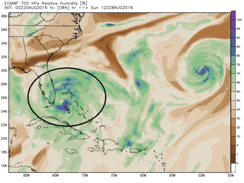
As the system conts to slowly move N and west it looks like both the GFS and Euro agree that 99l still has dry air issues to contend with as seen by the RH maps. This has been discussed prev on here and doesn't come as a big shock. Hr 36 first


By Hr 84 both GFS and Euro no longer seem to have dry air issues.

It seems on both the GFS and Euro forecast the system will cont to experience at least moderate shear for the next 24hrs. However after that both forecasts show the shear dropping off significantly. Its at this time that the wave is entering the Bahamas. I still do not trust the GFS soln of an open wave in the Bahamas and no real development. I have to believe based in the idea that the shear environment will improve and SST in this areas are extremely high that as long as there is not too much dry air entrained in the system that it will in fact develop into a trop storm and/or hurricane right before making landfall somewhere on the EC of Fla. I will hold off on trying to figure out the track after it crosses into Fla for now because there are still way to many uncertainties for the next 1-3days regarding development, or lack thereof. I certainly would not sleep on this system regardless of what the models say because if the conditions become just right, which is def possible, this system can develop fast and furious.
We track!
_________________
"In weather and in life, there's no winning and losing; there's only winning and learning."
WINTER 2012/2013 TOTALS 43.65"WINTER 2017/2018 TOTALS 62.85" WINTER 2022/2023 TOTALS 4.9"
WINTER 2013/2014 TOTALS 64.85"WINTER 2018/2019 TOTALS 14.25" WINTER 2023/2024 TOTALS 13.1"
WINTER 2014/2015 TOTALS 71.20"WINTER 2019/2020 TOTALS 6.35"
WINTER 2015/2016 TOTALS 35.00"WINTER 2020/2021 TOTALS 37.75"
WINTER 2016/2017 TOTALS 42.25"WINTER 2021/2022 TOTALS 31.65"

sroc4- Admin
- Posts : 8331
Reputation : 301
Join date : 2013-01-07
Location : Wading River, LI
Re: 2016 Tropical Cyclone Discussions
![]() by NjWeatherGuy Thu Aug 25, 2016 8:36 am
by NjWeatherGuy Thu Aug 25, 2016 8:36 am
http://mp1.met.psu.edu/~fxg1/WRFEAST_6z/wrfloop.html#picture
NjWeatherGuy- Advanced Forecaster
- Posts : 4100
Reputation : 28
Join date : 2013-01-06
Location : Belle Mead, NJ
Re: 2016 Tropical Cyclone Discussions
![]() by NjWeatherGuy Thu Aug 25, 2016 8:42 am
by NjWeatherGuy Thu Aug 25, 2016 8:42 am
http://meteocentre.com/models/explorateur.php?lang=en&map=na&run=00&mod=gemglb&stn=PNMPR&comp=1&run2=00&mod2=gemglb&stn2=PNMPR&hh2=084&fixhh=1&stn2_type=prog&mode=latest&yyyy=latest&mm=latest&dd=latest&hh=132
NjWeatherGuy- Advanced Forecaster
- Posts : 4100
Reputation : 28
Join date : 2013-01-06
Location : Belle Mead, NJ
Re: 2016 Tropical Cyclone Discussions
![]() by NjWeatherGuy Thu Aug 25, 2016 8:44 am
by NjWeatherGuy Thu Aug 25, 2016 8:44 am
NjWeatherGuy- Advanced Forecaster
- Posts : 4100
Reputation : 28
Join date : 2013-01-06
Location : Belle Mead, NJ
Re: 2016 Tropical Cyclone Discussions
![]() by Snow88 Thu Aug 25, 2016 8:46 am
by Snow88 Thu Aug 25, 2016 8:46 am
Landfall on the east coast lol

Snow88- Senior Enthusiast
- Posts : 2193
Reputation : 4
Join date : 2013-01-09
Age : 35
Location : Brooklyn, NY
Re: 2016 Tropical Cyclone Discussions
![]() by amugs Thu Aug 25, 2016 9:10 am
by amugs Thu Aug 25, 2016 9:10 am
How about this for eye candy peeps - HWRF - terrible model - suppose to be our (American) Hurricane Model

_________________
Mugs
AKA:King: Snow Weenie
Self Proclaimed
WINTER 2014-15 : 55.12" +.02 for 6 coatings (avg. 35")
WINTER 2015-16 Total - 29.8" (Avg 35")
WINTER 2016-17 : 39.5" so far

amugs- Advanced Forecaster - Mod

- Posts : 15093
Reputation : 213
Join date : 2013-01-07
Age : 54
Location : Hillsdale,NJ
Re: 2016 Tropical Cyclone Discussions
![]() by amugs Thu Aug 25, 2016 9:22 am
by amugs Thu Aug 25, 2016 9:22 am

_________________
Mugs
AKA:King: Snow Weenie
Self Proclaimed
WINTER 2014-15 : 55.12" +.02 for 6 coatings (avg. 35")
WINTER 2015-16 Total - 29.8" (Avg 35")
WINTER 2016-17 : 39.5" so far
amugs- Advanced Forecaster - Mod
- Posts : 15093
Reputation : 213
Join date : 2013-01-07
Age : 54
Location : Hillsdale,NJ
Re: 2016 Tropical Cyclone Discussions
![]() by sroc4 Thu Aug 25, 2016 10:06 am
by sroc4 Thu Aug 25, 2016 10:06 am
amugs wrote:SROC - awesome write ups that last couple of days and welcome back!!
How about this for eye candy peeps - HWRF - terrible model - suppose to be our (American) Hurricane Model
THanks Mugs. Great to be back. Nice to have something to track. I wouldnt discount this soln yet. If it makes it into the Gulf it will likely undergo rapid intensification.
_________________
"In weather and in life, there's no winning and losing; there's only winning and learning."
WINTER 2012/2013 TOTALS 43.65"WINTER 2017/2018 TOTALS 62.85" WINTER 2022/2023 TOTALS 4.9"
WINTER 2013/2014 TOTALS 64.85"WINTER 2018/2019 TOTALS 14.25" WINTER 2023/2024 TOTALS 13.1"
WINTER 2014/2015 TOTALS 71.20"WINTER 2019/2020 TOTALS 6.35"
WINTER 2015/2016 TOTALS 35.00"WINTER 2020/2021 TOTALS 37.75"
WINTER 2016/2017 TOTALS 42.25"WINTER 2021/2022 TOTALS 31.65"
sroc4- Admin
- Posts : 8331
Reputation : 301
Join date : 2013-01-07
Location : Wading River, LI
Re: 2016 Tropical Cyclone Discussions
![]() by Snow88 Thu Aug 25, 2016 10:48 am
by Snow88 Thu Aug 25, 2016 10:48 am
Snow88- Senior Enthusiast
- Posts : 2193
Reputation : 4
Join date : 2013-01-09
Age : 35
Location : Brooklyn, NY
Re: 2016 Tropical Cyclone Discussions
![]() by NjWeatherGuy Thu Aug 25, 2016 12:10 pm
by NjWeatherGuy Thu Aug 25, 2016 12:10 pm
www.wunderground.com/hurricane/atlantic/2016/Invest-99L?map=ensmodel
NjWeatherGuy- Advanced Forecaster
- Posts : 4100
Reputation : 28
Join date : 2013-01-06
Location : Belle Mead, NJ
Re: 2016 Tropical Cyclone Discussions
![]() by sroc4 Thu Aug 25, 2016 12:44 pm
by sroc4 Thu Aug 25, 2016 12:44 pm


_________________
"In weather and in life, there's no winning and losing; there's only winning and learning."
WINTER 2012/2013 TOTALS 43.65"WINTER 2017/2018 TOTALS 62.85" WINTER 2022/2023 TOTALS 4.9"
WINTER 2013/2014 TOTALS 64.85"WINTER 2018/2019 TOTALS 14.25" WINTER 2023/2024 TOTALS 13.1"
WINTER 2014/2015 TOTALS 71.20"WINTER 2019/2020 TOTALS 6.35"
WINTER 2015/2016 TOTALS 35.00"WINTER 2020/2021 TOTALS 37.75"
WINTER 2016/2017 TOTALS 42.25"WINTER 2021/2022 TOTALS 31.65"
sroc4- Admin
- Posts : 8331
Reputation : 301
Join date : 2013-01-07
Location : Wading River, LI
Re: 2016 Tropical Cyclone Discussions
![]() by rb924119 Thu Aug 25, 2016 12:47 pm
by rb924119 Thu Aug 25, 2016 12:47 pm
rb924119- Meteorologist

- Posts : 6890
Reputation : 194
Join date : 2013-02-06
Age : 32
Location : Greentown, Pa
Re: 2016 Tropical Cyclone Discussions
![]() by sroc4 Thu Aug 25, 2016 12:59 pm
by sroc4 Thu Aug 25, 2016 12:59 pm
rb924119 wrote:Yeah, it isn't looking too good, Sroc lmao Could the GFS actually do something right for once??????
Nah..the way I see it is even a blind squirrel finds a nut...even a broken clock is right twice a day...the sun occasionally shines on a dogs ars. I could keep going.
 We will see what happens after its out of the high shear its been experiencing. The more I look the more un stacked the mid level virticity actually is from the surface spin. I still would not sleep on the system however, esp if it makes it into the gulf.
 _________________
"In weather and in life, there's no winning and losing; there's only winning and learning."
WINTER 2012/2013 TOTALS 43.65"WINTER 2017/2018 TOTALS 62.85" WINTER 2022/2023 TOTALS 4.9"
WINTER 2013/2014 TOTALS 64.85"WINTER 2018/2019 TOTALS 14.25" WINTER 2023/2024 TOTALS 13.1"
WINTER 2014/2015 TOTALS 71.20"WINTER 2019/2020 TOTALS 6.35"
WINTER 2015/2016 TOTALS 35.00"WINTER 2020/2021 TOTALS 37.75"
WINTER 2016/2017 TOTALS 42.25"WINTER 2021/2022 TOTALS 31.65"
sroc4- Admin
- Posts : 8331
Reputation : 301
Join date : 2013-01-07
Location : Wading River, LI
Re: 2016 Tropical Cyclone Discussions
![]() by sroc4 Thu Aug 25, 2016 2:36 pm
by sroc4 Thu Aug 25, 2016 2:36 pm
_________________
"In weather and in life, there's no winning and losing; there's only winning and learning."
WINTER 2012/2013 TOTALS 43.65"WINTER 2017/2018 TOTALS 62.85" WINTER 2022/2023 TOTALS 4.9"
WINTER 2013/2014 TOTALS 64.85"WINTER 2018/2019 TOTALS 14.25" WINTER 2023/2024 TOTALS 13.1"
WINTER 2014/2015 TOTALS 71.20"WINTER 2019/2020 TOTALS 6.35"
WINTER 2015/2016 TOTALS 35.00"WINTER 2020/2021 TOTALS 37.75"
WINTER 2016/2017 TOTALS 42.25"WINTER 2021/2022 TOTALS 31.65"
sroc4- Admin
- Posts : 8331
Reputation : 301
Join date : 2013-01-07
Location : Wading River, LI
Re: 2016 Tropical Cyclone Discussions
![]() by amugs Thu Aug 25, 2016 3:13 pm
by amugs Thu Aug 25, 2016 3:13 pm


_________________
Mugs
AKA:King: Snow Weenie
Self Proclaimed
WINTER 2014-15 : 55.12" +.02 for 6 coatings (avg. 35")
WINTER 2015-16 Total - 29.8" (Avg 35")
WINTER 2016-17 : 39.5" so far
amugs- Advanced Forecaster - Mod
- Posts : 15093
Reputation : 213
Join date : 2013-01-07
Age : 54
Location : Hillsdale,NJ
Re: 2016 Tropical Cyclone Discussions
![]() by Frank_Wx Thu Aug 25, 2016 3:17 pm
by Frank_Wx Thu Aug 25, 2016 3:17 pm
_________________
_______________________________________________________________________________________________________
CLICK HERE to view NJ Strong Snowstorm Classifications
Frank_Wx- Godzilla Seeker
- Posts : 21305
Reputation : 328
Join date : 2013-01-05
Age : 31
Location : Jersey City, NJ -
Re: 2016 Tropical Cyclone Discussions
![]() by jmanley32 Thu Aug 25, 2016 3:28 pm
by jmanley32 Thu Aug 25, 2016 3:28 pm

jmanley32- Senior Enthusiast
- Posts : 20516
Reputation : 108
Join date : 2013-12-12
Age : 42
Location : Yonkers, NY
Re: 2016 Tropical Cyclone Discussions
![]() by Frank_Wx Thu Aug 25, 2016 4:21 pm
by Frank_Wx Thu Aug 25, 2016 4:21 pm
_________________
_______________________________________________________________________________________________________
CLICK HERE to view NJ Strong Snowstorm Classifications
Frank_Wx- Godzilla Seeker
- Posts : 21305
Reputation : 328
Join date : 2013-01-05
Age : 31
Location : Jersey City, NJ -
Re: 2016 Tropical Cyclone Discussions
![]() by sroc4 Thu Aug 25, 2016 4:25 pm
by sroc4 Thu Aug 25, 2016 4:25 pm
Frank_Wx wrote:Ehh lots of ensembles still have it going into the Gulf. Not sold on any solution yer
With the potential you just cant let the guard down yet. The OHC of the SE coast and GOM is simply too high. This could still go zero to sixty pretty quickly.
_________________
"In weather and in life, there's no winning and losing; there's only winning and learning."
WINTER 2012/2013 TOTALS 43.65"WINTER 2017/2018 TOTALS 62.85" WINTER 2022/2023 TOTALS 4.9"
WINTER 2013/2014 TOTALS 64.85"WINTER 2018/2019 TOTALS 14.25" WINTER 2023/2024 TOTALS 13.1"
WINTER 2014/2015 TOTALS 71.20"WINTER 2019/2020 TOTALS 6.35"
WINTER 2015/2016 TOTALS 35.00"WINTER 2020/2021 TOTALS 37.75"
WINTER 2016/2017 TOTALS 42.25"WINTER 2021/2022 TOTALS 31.65"
sroc4- Admin
- Posts : 8331
Reputation : 301
Join date : 2013-01-07
Location : Wading River, LI
Page 12 of 33 • 1 ... 7 ... 11, 12, 13 ... 22 ... 33 ![]()
|
|
|