
 Search
2016 Tropical Cyclone Discussions
Page 22 of 33 •  1 ... 12 ... 21, 22, 23 ... 27 ... 33
 ![]()
Re: 2016 Tropical Cyclone Discussions
![]() by jmanley32 Wed Sep 14, 2016 2:05 pm
by jmanley32 Wed Sep 14, 2016 2:05 pm
jmanley32- Senior Enthusiast

- Posts : 20516
Join date : 2013-12-12
Re: 2016 Tropical Cyclone Discussions
![]() by NjWeatherGuy Wed Sep 14, 2016 2:15 pm
by NjWeatherGuy Wed Sep 14, 2016 2:15 pm
jmanley32 wrote:Any chance Julia poses a threat to area if she stays as slow as she is and misses front? Hermine wasn't supposed to be a threat to the area and decided to be after crossing FL (well on her lead up to FL). sroc from the Euro image I posted above looks like if that went out further in time there is a escape route to N and then NE, or would it stay under the HP as modeled in that run? If we going to see any more threats its probably going to be very end of September through October, IMO. Been a active season but nothing really monstrous, we still are supposed to see a few more majors but unless conditions improve I do not know if I see that happening.
Dont think so, HP looks to keep it suppressed out of the area and eventually it just stalls off the coast and the energy is picked up/kicked out by front. Dont see enough interaction to pull it up the coast although the models are a bit more robust with the system off the coast today but still well to the south, we just get the front perhaps with a bit of enhancement.
http://collaboration.cmc.ec.gc.ca/cmc/cmdn/pcpn_type/pcpn_type_gem_reg.html
NjWeatherGuy- Advanced Forecaster

- Posts : 4100
Join date : 2013-01-06
Re: 2016 Tropical Cyclone Discussions
![]() by jmanley32 Wed Sep 14, 2016 2:18 pm
by jmanley32 Wed Sep 14, 2016 2:18 pm

jmanley32- Senior Enthusiast
- Posts : 20516
Reputation : 108
Join date : 2013-12-12
Age : 42
Location : Yonkers, NY
Re: 2016 Tropical Cyclone Discussions
![]() by jmanley32 Wed Sep 14, 2016 2:33 pm
by jmanley32 Wed Sep 14, 2016 2:33 pm
amugs wrote:Why is the Atlantic so hostile for Jman's dear tropical cyclones??The answer is in this map below

Its primo over off the EC, but they have to traverse that very dry area, which is difficult to say the least.
jmanley32- Senior Enthusiast
- Posts : 20516
Reputation : 108
Join date : 2013-12-12
Age : 42
Location : Yonkers, NY
Re: 2016 Tropical Cyclone Discussions
![]() by NjWeatherGuy Wed Sep 14, 2016 2:49 pm
by NjWeatherGuy Wed Sep 14, 2016 2:49 pm
jmanley32 wrote:amugs wrote:Why is the Atlantic so hostile for Jman's dear tropical cyclones??The answer is in this map below
Its primo over off the EC, but they have to traverse that very dry area, which is difficult to say the least.
That area has been improving over all, still very dry in the Caribbean but not as bad by Africa and in the C-Atl as it was earlier like last week.

NjWeatherGuy- Advanced Forecaster
- Posts : 4100
Reputation : 28
Join date : 2013-01-06
Location : Belle Mead, NJ
Re: 2016 Tropical Cyclone Discussions
![]() by sroc4 Wed Sep 14, 2016 3:04 pm
by sroc4 Wed Sep 14, 2016 3:04 pm
NjWeatherGuy wrote:jmanley32 wrote:Any chance Julia poses a threat to area if she stays as slow as she is and misses front? Hermine wasn't supposed to be a threat to the area and decided to be after crossing FL (well on her lead up to FL). sroc from the Euro image I posted above looks like if that went out further in time there is a escape route to N and then NE, or would it stay under the HP as modeled in that run? If we going to see any more threats its probably going to be very end of September through October, IMO. Been a active season but nothing really monstrous, we still are supposed to see a few more majors but unless conditions improve I do not know if I see that happening.
Dont think so, HP looks to keep it suppressed out of the area and eventually it just stalls off the coast and the energy is picked up/kicked out by front. Dont see enough interaction to pull it up the coast although the models are a bit more robust with the system off the coast today but still well to the south, we just get the front perhaps with a bit of enhancement.
http://collaboration.cmc.ec.gc.ca/cmc/cmdn/pcpn_type/pcpn_type_gem_reg.html
Agreed if anything if the front stalls close to the coast or backs up some there may be some enhanced rainfall but I don't see a mechanism to bring the main components of Julie north to our area. Regarding extrapolating the euro I'll say there is a weakness in the ridge to the north with a trough dipping in between, and a low pressure east of the main system. It's what happens to these features combined with how strong the system is as well as just how far north or south it is by the time it gets to that longitude that would dictate where the system goes from there. Two many variables to guess at this point.
_________________
"In weather and in life, there's no winning and losing; there's only winning and learning."
WINTER 2012/2013 TOTALS 43.65"WINTER 2017/2018 TOTALS 62.85" WINTER 2022/2023 TOTALS 4.9"
WINTER 2013/2014 TOTALS 64.85"WINTER 2018/2019 TOTALS 14.25" WINTER 2023/2024 TOTALS 13.1"
WINTER 2014/2015 TOTALS 71.20"WINTER 2019/2020 TOTALS 6.35"
WINTER 2015/2016 TOTALS 35.00"WINTER 2020/2021 TOTALS 37.75"
WINTER 2016/2017 TOTALS 42.25"WINTER 2021/2022 TOTALS 31.65"

sroc4- Admin

- Posts : 8331
Reputation : 301
Join date : 2013-01-07
Location : Wading River, LI
Re: 2016 Tropical Cyclone Discussions
![]() by jmanley32 Wed Sep 14, 2016 4:42 pm
by jmanley32 Wed Sep 14, 2016 4:42 pm
sroc4 wrote:NjWeatherGuy wrote:jmanley32 wrote:Any chance Julia poses a threat to area if she stays as slow as she is and misses front? Hermine wasn't supposed to be a threat to the area and decided to be after crossing FL (well on her lead up to FL). sroc from the Euro image I posted above looks like if that went out further in time there is a escape route to N and then NE, or would it stay under the HP as modeled in that run? If we going to see any more threats its probably going to be very end of September through October, IMO. Been a active season but nothing really monstrous, we still are supposed to see a few more majors but unless conditions improve I do not know if I see that happening.
Dont think so, HP looks to keep it suppressed out of the area and eventually it just stalls off the coast and the energy is picked up/kicked out by front. Dont see enough interaction to pull it up the coast although the models are a bit more robust with the system off the coast today but still well to the south, we just get the front perhaps with a bit of enhancement.
http://collaboration.cmc.ec.gc.ca/cmc/cmdn/pcpn_type/pcpn_type_gem_reg.html
Agreed if anything if the front stalls close to the coast or backs up some there may be some enhanced rainfall but I don't see a mechanism to bring the main components of Julie north to our area. Regarding extrapolating the euro I'll say there is a weakness in the ridge to the north with a trough dipping in between, and a low pressure east of the main system. It's what happens to these features combined with how strong the system is as well as just how far north or south it is by the time it gets to that longitude that would dictate where the system goes from there. Two many variables to guess at this point.
Yes, I was just merely stating on that particular run it looked like there was a gap between the two HP that could allow it to go ots. If it does intensify to what the Euro shows this could be our next major and could possibly post a threat to the US late next week, as it appears it will be a fast mover, but that can also hinter systems.
jmanley32- Senior Enthusiast
- Posts : 20516
Reputation : 108
Join date : 2013-12-12
Age : 42
Location : Yonkers, NY
Re: 2016 Tropical Cyclone Discussions
![]() by jmanley32 Wed Sep 14, 2016 4:49 pm
by jmanley32 Wed Sep 14, 2016 4:49 pm
http://www.ssd.noaa.gov/PS/TROP/floaters/12L/imagery/rgb-animated.gif
jmanley32- Senior Enthusiast
- Posts : 20516
Reputation : 108
Join date : 2013-12-12
Age : 42
Location : Yonkers, NY
Re: 2016 Tropical Cyclone Discussions
![]() by NjWeatherGuy Wed Sep 14, 2016 5:54 pm
by NjWeatherGuy Wed Sep 14, 2016 5:54 pm
NjWeatherGuy- Advanced Forecaster
- Posts : 4100
Reputation : 28
Join date : 2013-01-06
Location : Belle Mead, NJ
Re: 2016 Tropical Cyclone Discussions
![]() by sroc4 Wed Sep 14, 2016 8:08 pm
by sroc4 Wed Sep 14, 2016 8:08 pm
NjWeatherGuy wrote:Sroc Id say the EURO shoots the gap between the HP with the Hcane its blowing up out of 12 and passes just east of Bermuda, obviously lots of time left but the CMC has the signal too.
I can def buy that given the current forecasted 500mb. Lots of runs to go though. FWIW it looks like the new NHC forecast for TS Julia is in line with the CMC with the center drifting out over water and the possibility of minor strengthening over the next 1-2 days.

TROPICAL STORM JULIA DISCUSSION NUMBER 4
NWS NATIONAL HURRICANE CENTER MIAMI FL AL112016
500 PM EDT WED SEP 14 2016
The storm continues to have an asymmetric cloud pattern, with
little deep convection over the western and southern portions of
the circulation. The current intensity estimate remains at 35 kt
based on WSR-88D Doppler velocity data. Since the system is
expected to be over water for the next couple of days, some
strengthening is now possible. However the vertical shear, which
is currently approaching 20 kt, is forecast by the dynamical models
to increase to near 30 kt in 48 hours. This strong shear should
limit significant intensification, as indicated in the latest
official forecast. The NHC forecast is also very close to
the latest intensity model consensus.


_________________
"In weather and in life, there's no winning and losing; there's only winning and learning."
WINTER 2012/2013 TOTALS 43.65"WINTER 2017/2018 TOTALS 62.85" WINTER 2022/2023 TOTALS 4.9"
WINTER 2013/2014 TOTALS 64.85"WINTER 2018/2019 TOTALS 14.25" WINTER 2023/2024 TOTALS 13.1"
WINTER 2014/2015 TOTALS 71.20"WINTER 2019/2020 TOTALS 6.35"
WINTER 2015/2016 TOTALS 35.00"WINTER 2020/2021 TOTALS 37.75"
WINTER 2016/2017 TOTALS 42.25"WINTER 2021/2022 TOTALS 31.65"
sroc4- Admin
- Posts : 8331
Reputation : 301
Join date : 2013-01-07
Location : Wading River, LI
Re: 2016 Tropical Cyclone Discussions
![]() by NjWeatherGuy Thu Sep 15, 2016 1:58 am
by NjWeatherGuy Thu Sep 15, 2016 1:58 am
http://collaboration.cmc.ec.gc.ca/cmc/cmdn/pcpn_type/pcpn_type_gem_reg.html
NjWeatherGuy- Advanced Forecaster
- Posts : 4100
Reputation : 28
Join date : 2013-01-06
Location : Belle Mead, NJ


Snow88- Senior Enthusiast
- Posts : 2193
Reputation : 4
Join date : 2013-01-09
Age : 35
Location : Brooklyn, NY
Re: 2016 Tropical Cyclone Discussions
![]() by sroc4 Thu Sep 15, 2016 10:12 am
by sroc4 Thu Sep 15, 2016 10:12 am
Snow88 wrote:Next one to track?
The NHC forecast cone has already shifted south relative to yesterday. I wish I saved the image from yesterday but I did saved this one. If anyone has saved it please post it in here please. Each morning I am going to save this image so we can monitor the changes in the NHC forecast track over time.
_________________
"In weather and in life, there's no winning and losing; there's only winning and learning."
WINTER 2012/2013 TOTALS 43.65"WINTER 2017/2018 TOTALS 62.85" WINTER 2022/2023 TOTALS 4.9"
WINTER 2013/2014 TOTALS 64.85"WINTER 2018/2019 TOTALS 14.25" WINTER 2023/2024 TOTALS 13.1"
WINTER 2014/2015 TOTALS 71.20"WINTER 2019/2020 TOTALS 6.35"
WINTER 2015/2016 TOTALS 35.00"WINTER 2020/2021 TOTALS 37.75"
WINTER 2016/2017 TOTALS 42.25"WINTER 2021/2022 TOTALS 31.65"
sroc4- Admin
- Posts : 8331
Reputation : 301
Join date : 2013-01-07
Location : Wading River, LI
Re: 2016 Tropical Cyclone Discussions
![]() by jmanley32 Thu Sep 15, 2016 2:35 pm
by jmanley32 Thu Sep 15, 2016 2:35 pm
jmanley32- Senior Enthusiast
- Posts : 20516
Reputation : 108
Join date : 2013-12-12
Age : 42
Location : Yonkers, NY
Re: 2016 Tropical Cyclone Discussions
![]() by jmanley32 Thu Sep 15, 2016 2:36 pm
by jmanley32 Thu Sep 15, 2016 2:36 pm
jmanley32- Senior Enthusiast
- Posts : 20516
Reputation : 108
Join date : 2013-12-12
Age : 42
Location : Yonkers, NY
Re: 2016 Tropical Cyclone Discussions
![]() by sroc4 Thu Sep 15, 2016 3:26 pm
by sroc4 Thu Sep 15, 2016 3:26 pm
jmanley32 wrote:Staying south would give this a further west track no?
Yes. Also the weaker it stays the further west it will go.
_________________
"In weather and in life, there's no winning and losing; there's only winning and learning."
WINTER 2012/2013 TOTALS 43.65"WINTER 2017/2018 TOTALS 62.85" WINTER 2022/2023 TOTALS 4.9"
WINTER 2013/2014 TOTALS 64.85"WINTER 2018/2019 TOTALS 14.25" WINTER 2023/2024 TOTALS 13.1"
WINTER 2014/2015 TOTALS 71.20"WINTER 2019/2020 TOTALS 6.35"
WINTER 2015/2016 TOTALS 35.00"WINTER 2020/2021 TOTALS 37.75"
WINTER 2016/2017 TOTALS 42.25"WINTER 2021/2022 TOTALS 31.65"
sroc4- Admin
- Posts : 8331
Reputation : 301
Join date : 2013-01-07
Location : Wading River, LI
Re: 2016 Tropical Cyclone Discussions
![]() by NjWeatherGuy Thu Sep 15, 2016 5:04 pm
by NjWeatherGuy Thu Sep 15, 2016 5:04 pm
sroc4 wrote:jmanley32 wrote:Staying south would give this a further west track no?
Yes. Also the weaker it stays the further west it will go.
Yep, doesnt mean it will hit land though (US landfall) as I still see a gap in the HPs it could escape through if it deepens fast enough. A recurve could happen very sharply and often does but its something to watch, esp. If the pac recurve rule (with the big typhoon that just hit) actually is true but I'm always wary of things like that.
NjWeatherGuy- Advanced Forecaster
- Posts : 4100
Reputation : 28
Join date : 2013-01-06
Location : Belle Mead, NJ
Re: 2016 Tropical Cyclone Discussions
![]() by amugs Thu Sep 15, 2016 9:27 pm
by amugs Thu Sep 15, 2016 9:27 pm

Saharan Dust diminished to menial bits
.jpg)
_________________
Mugs
AKA:King: Snow Weenie
Self Proclaimed
WINTER 2014-15 : 55.12" +.02 for 6 coatings (avg. 35")
WINTER 2015-16 Total - 29.8" (Avg 35")
WINTER 2016-17 : 39.5" so far

amugs- Advanced Forecaster - Mod

- Posts : 15093
Reputation : 213
Join date : 2013-01-07
Age : 54
Location : Hillsdale,NJ
Re: 2016 Tropical Cyclone Discussions
![]() by jmanley32 Thu Sep 15, 2016 9:33 pm
by jmanley32 Thu Sep 15, 2016 9:33 pm
Last edited by jmanley32 on Thu Sep 15, 2016 9:54 pm; edited 2 times in total
jmanley32- Senior Enthusiast
- Posts : 20516
Reputation : 108
Join date : 2013-12-12
Age : 42
Location : Yonkers, NY
Re: 2016 Tropical Cyclone Discussions
![]() by jmanley32 Thu Sep 15, 2016 9:34 pm
by jmanley32 Thu Sep 15, 2016 9:34 pm
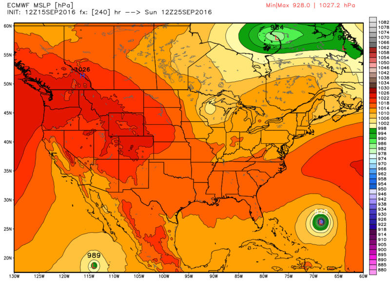
amugs wrote:Heat Content in the Caribbean and Gulf as well as EC is HOT!!
Saharan Dust diminished to menial bits
With this info Euro may not be too far off from the truth with TD12. Which is what is shown developing this monster cat 3. Wind gust map at that pt has 138kt gusts jeeze.
jmanley32- Senior Enthusiast
- Posts : 20516
Reputation : 108
Join date : 2013-12-12
Age : 42
Location : Yonkers, NY
Re: 2016 Tropical Cyclone Discussions
![]() by jmanley32 Thu Sep 15, 2016 9:43 pm
by jmanley32 Thu Sep 15, 2016 9:43 pm
http://www.ssd.noaa.gov/PS/TROP/floaters/12L/imagery/rb-animated.gif
jmanley32- Senior Enthusiast
- Posts : 20516
Reputation : 108
Join date : 2013-12-12
Age : 42
Location : Yonkers, NY

jmanley32- Senior Enthusiast
- Posts : 20516
Reputation : 108
Join date : 2013-12-12
Age : 42
Location : Yonkers, NY
Re: 2016 Tropical Cyclone Discussions
![]() by jmanley32 Thu Sep 15, 2016 9:58 pm
by jmanley32 Thu Sep 15, 2016 9:58 pm
jmanley32- Senior Enthusiast
- Posts : 20516
Reputation : 108
Join date : 2013-12-12
Age : 42
Location : Yonkers, NY
Re: 2016 Tropical Cyclone Discussions
![]() by jmanley32 Thu Sep 15, 2016 10:02 pm
by jmanley32 Thu Sep 15, 2016 10:02 pm

jmanley32- Senior Enthusiast
- Posts : 20516
Reputation : 108
Join date : 2013-12-12
Age : 42
Location : Yonkers, NY
Re: 2016 Tropical Cyclone Discussions
![]() by jmanley32 Thu Sep 15, 2016 10:06 pm
by jmanley32 Thu Sep 15, 2016 10:06 pm

jmanley32- Senior Enthusiast
- Posts : 20516
Reputation : 108
Join date : 2013-12-12
Age : 42
Location : Yonkers, NY
Re: 2016 Tropical Cyclone Discussions
![]() by jmanley32 Thu Sep 15, 2016 11:11 pm
by jmanley32 Thu Sep 15, 2016 11:11 pm

jmanley32- Senior Enthusiast
- Posts : 20516
Reputation : 108
Join date : 2013-12-12
Age : 42
Location : Yonkers, NY
Re: 2016 Tropical Cyclone Discussions
![]() by jmanley32 Fri Sep 16, 2016 5:17 am
by jmanley32 Fri Sep 16, 2016 5:17 am
jmanley32- Senior Enthusiast
- Posts : 20516
Reputation : 108
Join date : 2013-12-12
Age : 42
Location : Yonkers, NY
Page 22 of 33 • 1 ... 12 ... 21, 22, 23 ... 27 ... 33 ![]()
|
|
|