
 Search
2016 Tropical Cyclone Discussions
Page 27 of 33 •  1 ... 15 ... 26, 27, 28 ... 33
 ![]()
Re: 2016 Tropical Cyclone Discussions
![]() by jmanley32 Sun Sep 25, 2016 1:22 pm
by jmanley32 Sun Sep 25, 2016 1:22 pm
jmanley32- Senior Enthusiast

- Posts : 20516
Join date : 2013-12-12
Re: 2016 Tropical Cyclone Discussions
![]() by jmanley32 Sun Sep 25, 2016 1:24 pm
by jmanley32 Sun Sep 25, 2016 1:24 pm
how many days is that now? It's been pretty consistant. I hate being 12 days away from any kind of storm hurricane or winter. Time just drags lolSnow88 wrote:GEFS still like a storm a long the coast
jmanley32- Senior Enthusiast
- Posts : 20516
Join date : 2013-12-12
Re: 2016 Tropical Cyclone Discussions
![]() by jmanley32 Sun Sep 25, 2016 1:30 pm
by jmanley32 Sun Sep 25, 2016 1:30 pm

jmanley32- Senior Enthusiast
- Posts : 20516
Reputation : 108
Join date : 2013-12-12
Age : 42
Location : Yonkers, NY
Re: 2016 Tropical Cyclone Discussions
![]() by jmanley32 Sun Sep 25, 2016 3:44 pm
by jmanley32 Sun Sep 25, 2016 3:44 pm
jmanley32- Senior Enthusiast
- Posts : 20516
Reputation : 108
Join date : 2013-12-12
Age : 42
Location : Yonkers, NY
Re: 2016 Tropical Cyclone Discussions
![]() by sroc4 Sun Sep 25, 2016 5:54 pm
by sroc4 Sun Sep 25, 2016 5:54 pm
jmanley32 wrote:97l.has 30/90 now so nhc pretty confident in genesis in 5 day. Euro was interesting actually keeping this far east going north then west of pr and ots. Is that a viable solition. I've been reading it's unlikely it curves that much.
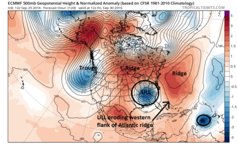
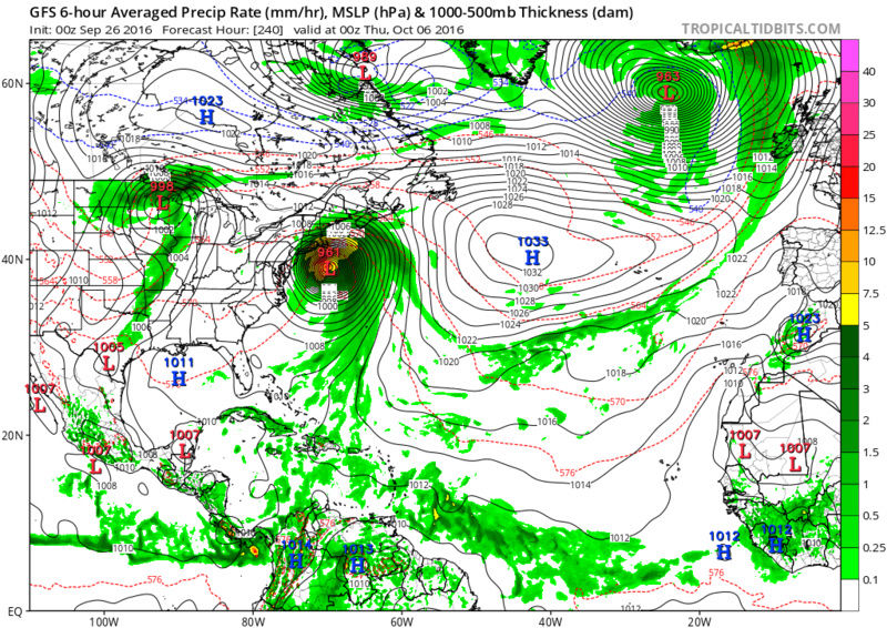
Its def a plausible soln given the latest trends and an OTS soln needs to be considered. Now ULL are hard to forecast on modeling in the LR so what I'm about to outline is merely a trend I see regarding the GFS towards the Euro. It is by no means the final soln nor am I ready to lock it in, but the latest trends are possibly hinting at an escape OTS. It will still likely affect the Islands of the Caribbean in this scenario but not the US.
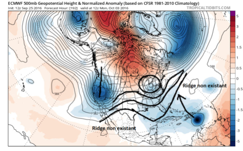
Lets look at the 12z European from today starting 12z Sept 30th(00z was similar)
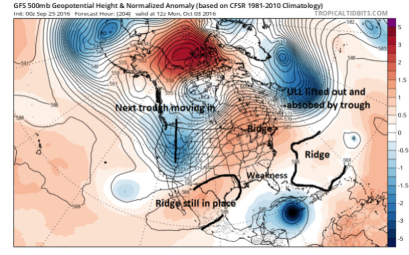
Now Lets look at 500mb on the GFS from 00z last night beginning same time frame.


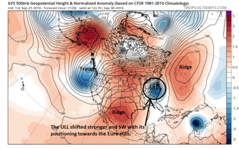
Now compare todays 12z GFS which trended towards the Euro. Here is why. Make sure to take a peak back up at the 00z for comparison. Again same time frame

_________________
"In weather and in life, there's no winning and losing; there's only winning and learning."
WINTER 2012/2013 TOTALS 43.65"WINTER 2017/2018 TOTALS 62.85" WINTER 2022/2023 TOTALS 4.9"
WINTER 2013/2014 TOTALS 64.85"WINTER 2018/2019 TOTALS 14.25" WINTER 2023/2024 TOTALS 13.1"
WINTER 2014/2015 TOTALS 71.20"WINTER 2019/2020 TOTALS 6.35"
WINTER 2015/2016 TOTALS 35.00"WINTER 2020/2021 TOTALS 37.75"
WINTER 2016/2017 TOTALS 42.25"WINTER 2021/2022 TOTALS 31.65"

sroc4- Admin

- Posts : 8331
Reputation : 301
Join date : 2013-01-07
Location : Wading River, LI
Re: 2016 Tropical Cyclone Discussions
![]() by sroc4 Sun Sep 25, 2016 6:05 pm
by sroc4 Sun Sep 25, 2016 6:05 pm
http://www.tropicaltidbits.com/
_________________
"In weather and in life, there's no winning and losing; there's only winning and learning."
WINTER 2012/2013 TOTALS 43.65"WINTER 2017/2018 TOTALS 62.85" WINTER 2022/2023 TOTALS 4.9"
WINTER 2013/2014 TOTALS 64.85"WINTER 2018/2019 TOTALS 14.25" WINTER 2023/2024 TOTALS 13.1"
WINTER 2014/2015 TOTALS 71.20"WINTER 2019/2020 TOTALS 6.35"
WINTER 2015/2016 TOTALS 35.00"WINTER 2020/2021 TOTALS 37.75"
WINTER 2016/2017 TOTALS 42.25"WINTER 2021/2022 TOTALS 31.65"
sroc4- Admin
- Posts : 8331
Reputation : 301
Join date : 2013-01-07
Location : Wading River, LI
Re: 2016 Tropical Cyclone Discussions
![]() by jmanley32 Sun Sep 25, 2016 6:23 pm
by jmanley32 Sun Sep 25, 2016 6:23 pm
jmanley32- Senior Enthusiast
- Posts : 20516
Reputation : 108
Join date : 2013-12-12
Age : 42
Location : Yonkers, NY
Re: 2016 Tropical Cyclone Discussions
![]() by jmanley32 Sun Sep 25, 2016 6:46 pm
by jmanley32 Sun Sep 25, 2016 6:46 pm

jmanley32- Senior Enthusiast
- Posts : 20516
Reputation : 108
Join date : 2013-12-12
Age : 42
Location : Yonkers, NY
Re: 2016 Tropical Cyclone Discussions
![]() by jmanley32 Sun Sep 25, 2016 6:50 pm
by jmanley32 Sun Sep 25, 2016 6:50 pm

jmanley32- Senior Enthusiast
- Posts : 20516
Reputation : 108
Join date : 2013-12-12
Age : 42
Location : Yonkers, NY
Re: 2016 Tropical Cyclone Discussions
![]() by jmanley32 Sun Sep 25, 2016 6:57 pm
by jmanley32 Sun Sep 25, 2016 6:57 pm
"
jmanley32- Senior Enthusiast
- Posts : 20516
Reputation : 108
Join date : 2013-12-12
Age : 42
Location : Yonkers, NY
Re: 2016 Tropical Cyclone Discussions
![]() by sroc4 Sun Sep 25, 2016 8:06 pm
by sroc4 Sun Sep 25, 2016 8:06 pm
jmanley32 wrote:This posted on another forum "Also the trough digging in around 252-288 is concerning...it has a Sandy-like feel at the end too.." So lots at play here, I remember with a storm that never happened frank had a banner about 12 days before a storm that was supposed to hit saying possible storm. Might a banner be put up if we continue to see close to the coast senarios of such disasterous intensity storms? I think I can answer this my self but was just curious why Frank did that last time and not now being this is showing a far worse storm. And god help anyone in the islands.
"
IF it misses the first deep layer trough (ULL) I outlined above and IF it is traveling north somewhere just off the coast and IF the timing of the next incoming trough is right and IF it digs and tilts negative then it could hook back into the coast. A lot of IFs
_________________
"In weather and in life, there's no winning and losing; there's only winning and learning."
WINTER 2012/2013 TOTALS 43.65"WINTER 2017/2018 TOTALS 62.85" WINTER 2022/2023 TOTALS 4.9"
WINTER 2013/2014 TOTALS 64.85"WINTER 2018/2019 TOTALS 14.25" WINTER 2023/2024 TOTALS 13.1"
WINTER 2014/2015 TOTALS 71.20"WINTER 2019/2020 TOTALS 6.35"
WINTER 2015/2016 TOTALS 35.00"WINTER 2020/2021 TOTALS 37.75"
WINTER 2016/2017 TOTALS 42.25"WINTER 2021/2022 TOTALS 31.65"
sroc4- Admin
- Posts : 8331
Reputation : 301
Join date : 2013-01-07
Location : Wading River, LI
Re: 2016 Tropical Cyclone Discussions
![]() by jmanley32 Sun Sep 25, 2016 8:38 pm
by jmanley32 Sun Sep 25, 2016 8:38 pm
sroc4 wrote:jmanley32 wrote:This posted on another forum "Also the trough digging in around 252-288 is concerning...it has a Sandy-like feel at the end too.." So lots at play here, I remember with a storm that never happened frank had a banner about 12 days before a storm that was supposed to hit saying possible storm. Might a banner be put up if we continue to see close to the coast senarios of such disasterous intensity storms? I think I can answer this my self but was just curious why Frank did that last time and not now being this is showing a far worse storm. And god help anyone in the islands.
"
IF it misses the first deep layer trough (ULL) I outlined above and IF it is traveling north somewhere just off the coast and IF the timing of the next incoming trough is right and IF it digs and tilts negative then it could hook back into the coast. A lot of IFs
All those things gotta happen together? It couldn't just ride the coast if it was further west, not talking a sandy track,i wouldn't imagine that (But it is the size of Sandy or close on that run and looks a lot like one of the in initial runs from sandy i saw in 2012 on the euro. but ya a lot of IF's. Once we have genesis in 3-4 days we should get a clearer idea. But yeah I am learning that theres so much more at play than just the system itself, and alot of people are also saying not only are the TC badly modeled this year but so have long term upper level troughs ridges etc. We Track.
jmanley32- Senior Enthusiast
- Posts : 20516
Reputation : 108
Join date : 2013-12-12
Age : 42
Location : Yonkers, NY
Re: 2016 Tropical Cyclone Discussions
![]() by jmanley32 Sun Sep 25, 2016 9:07 pm
by jmanley32 Sun Sep 25, 2016 9:07 pm

jmanley32- Senior Enthusiast
- Posts : 20516
Reputation : 108
Join date : 2013-12-12
Age : 42
Location : Yonkers, NY
Re: 2016 Tropical Cyclone Discussions
![]() by jmanley32 Mon Sep 26, 2016 12:46 am
by jmanley32 Mon Sep 26, 2016 12:46 am
Is it the fact that Low pulled out and the HP got to the east of it why it made it more towards coast?
I hate to say it but this may not pull the track but this has sandy intensity or higher written all over it on that run, the eastward movement may have stopped and we may now see it stay this way or back even further west.
jmanley32- Senior Enthusiast
- Posts : 20516
Reputation : 108
Join date : 2013-12-12
Age : 42
Location : Yonkers, NY
Re: 2016 Tropical Cyclone Discussions
![]() by Snow88 Mon Sep 26, 2016 1:17 am
by Snow88 Mon Sep 26, 2016 1:17 am

Snow88- Senior Enthusiast
- Posts : 2193
Reputation : 4
Join date : 2013-01-09
Age : 35
Location : Brooklyn, NY
Re: 2016 Tropical Cyclone Discussions
![]() by NjWeatherGuy Mon Sep 26, 2016 1:33 am
by NjWeatherGuy Mon Sep 26, 2016 1:33 am

NjWeatherGuy- Advanced Forecaster

- Posts : 4100
Reputation : 28
Join date : 2013-01-06
Location : Belle Mead, NJ
Re: 2016 Tropical Cyclone Discussions
![]() by jmanley32 Mon Sep 26, 2016 6:27 am
by jmanley32 Mon Sep 26, 2016 6:27 am
jmanley32- Senior Enthusiast
- Posts : 20516
Reputation : 108
Join date : 2013-12-12
Age : 42
Location : Yonkers, NY
Re: 2016 Tropical Cyclone Discussions
![]() by sroc4 Mon Sep 26, 2016 6:32 am
by sroc4 Mon Sep 26, 2016 6:32 am
12z yesterday:

00z Last night:

We first have to nail down what the pattern is doing in the 3-5day. There are still differences in intensity and track to 97L as it enters the Caribbean.
Euro

GFS

CMC

_________________
"In weather and in life, there's no winning and losing; there's only winning and learning."
WINTER 2012/2013 TOTALS 43.65"WINTER 2017/2018 TOTALS 62.85" WINTER 2022/2023 TOTALS 4.9"
WINTER 2013/2014 TOTALS 64.85"WINTER 2018/2019 TOTALS 14.25" WINTER 2023/2024 TOTALS 13.1"
WINTER 2014/2015 TOTALS 71.20"WINTER 2019/2020 TOTALS 6.35"
WINTER 2015/2016 TOTALS 35.00"WINTER 2020/2021 TOTALS 37.75"
WINTER 2016/2017 TOTALS 42.25"WINTER 2021/2022 TOTALS 31.65"
sroc4- Admin
- Posts : 8331
Reputation : 301
Join date : 2013-01-07
Location : Wading River, LI
Re: 2016 Tropical Cyclone Discussions
![]() by jmanley32 Mon Sep 26, 2016 6:39 am
by jmanley32 Mon Sep 26, 2016 6:39 am
jmanley32- Senior Enthusiast
- Posts : 20516
Reputation : 108
Join date : 2013-12-12
Age : 42
Location : Yonkers, NY
Re: 2016 Tropical Cyclone Discussions
![]() by NjWeatherGuy Mon Sep 26, 2016 6:57 am
by NjWeatherGuy Mon Sep 26, 2016 6:57 am
NjWeatherGuy- Advanced Forecaster
- Posts : 4100
Reputation : 28
Join date : 2013-01-06
Location : Belle Mead, NJ
Re: 2016 Tropical Cyclone Discussions
![]() by NjWeatherGuy Mon Sep 26, 2016 7:00 am
by NjWeatherGuy Mon Sep 26, 2016 7:00 am
NjWeatherGuy- Advanced Forecaster
- Posts : 4100
Reputation : 28
Join date : 2013-01-06
Location : Belle Mead, NJ
Re: 2016 Tropical Cyclone Discussions
![]() by NjWeatherGuy Mon Sep 26, 2016 7:58 am
by NjWeatherGuy Mon Sep 26, 2016 7:58 am
http://mp1.met.psu.edu/~fxg1/ENSPRS_0z/ensloopnew.html#picture
NjWeatherGuy- Advanced Forecaster
- Posts : 4100
Reputation : 28
Join date : 2013-01-06
Location : Belle Mead, NJ
Re: 2016 Tropical Cyclone Discussions
![]() by oldtimer Mon Sep 26, 2016 8:02 am
by oldtimer Mon Sep 26, 2016 8:02 am
oldtimer- Senior Enthusiast
- Posts : 1103
Reputation : 14
Join date : 2013-01-16
Age : 78
Location : Port Jefferson Station Suffolk County
Re: 2016 Tropical Cyclone Discussions
![]() by Snow88 Mon Sep 26, 2016 8:27 am
by Snow88 Mon Sep 26, 2016 8:27 am
Way west of the GFS

Snow88- Senior Enthusiast
- Posts : 2193
Reputation : 4
Join date : 2013-01-09
Age : 35
Location : Brooklyn, NY
Re: 2016 Tropical Cyclone Discussions
![]() by jmanley32 Mon Sep 26, 2016 8:50 am
by jmanley32 Mon Sep 26, 2016 8:50 am
Last edited by jmanley32 on Mon Sep 26, 2016 8:57 am; edited 1 time in total
jmanley32- Senior Enthusiast
- Posts : 20516
Reputation : 108
Join date : 2013-12-12
Age : 42
Location : Yonkers, NY
Re: 2016 Tropical Cyclone Discussions
![]() by jmanley32 Mon Sep 26, 2016 8:53 am
by jmanley32 Mon Sep 26, 2016 8:53 am
why is this concerning I thought nav gem was a pretty bad model. Is that why? If it's show in close then the gfs should too? Which it has plenty of runs. I think those ensembles are the only ones so far that have had direct landfall in the area.NjWeatherGuy wrote:When the NAVGEM is west of the GFS its a bit concerning IMO, its 0z run looked to take aim at Florida and 6z running now.
jmanley32- Senior Enthusiast
- Posts : 20516
Reputation : 108
Join date : 2013-12-12
Age : 42
Location : Yonkers, NY
Re: 2016 Tropical Cyclone Discussions
![]() by jmanley32 Mon Sep 26, 2016 9:06 am
by jmanley32 Mon Sep 26, 2016 9:06 am
what we're u trying to ask here? It being south is a good thing unless it plows into sa but so far there no solution showing that. Latest intensity models have it a ts in 36 hrs and ramps up over 5 days to as high as cat 2 to 5.oldtimer wrote:Isn't it to far south to delvelop at 8* lay??
jmanley32- Senior Enthusiast
- Posts : 20516
Reputation : 108
Join date : 2013-12-12
Age : 42
Location : Yonkers, NY
Page 27 of 33 • 1 ... 15 ... 26, 27, 28 ... 33 ![]()
|
|
|