
 Search
2016 Tropical Cyclone Discussions
Page 28 of 33 •  1 ... 15 ... 27, 28, 29 ... 33
 ![]()
Re: 2016 Tropical Cyclone Discussions
![]() by jmanley32 Mon Sep 26, 2016 8:53 am
by jmanley32 Mon Sep 26, 2016 8:53 am
why is this concerning I thought nav gem was a pretty bad model. Is that why? If it's show in close then the gfs should too? Which it has plenty of runs. I think those ensembles are the only ones so far that have had direct landfall in the area.NjWeatherGuy wrote:When the NAVGEM is west of the GFS its a bit concerning IMO, its 0z run looked to take aim at Florida and 6z running now.
jmanley32- Senior Enthusiast

- Posts : 20513
Join date : 2013-12-12
Re: 2016 Tropical Cyclone Discussions
![]() by jmanley32 Mon Sep 26, 2016 9:06 am
by jmanley32 Mon Sep 26, 2016 9:06 am
what we're u trying to ask here? It being south is a good thing unless it plows into sa but so far there no solution showing that. Latest intensity models have it a ts in 36 hrs and ramps up over 5 days to as high as cat 2 to 5.oldtimer wrote:Isn't it to far south to delvelop at 8* lay??
jmanley32- Senior Enthusiast
- Posts : 20513
Join date : 2013-12-12
Re: 2016 Tropical Cyclone Discussions
![]() by NjWeatherGuy Mon Sep 26, 2016 9:15 am
by NjWeatherGuy Mon Sep 26, 2016 9:15 am
jmanley32 wrote:why is this concerning I thought nav gem was a pretty bad model. Is that why? If it's show in close then the gfs should too? Which it has plenty of runs. I think those ensembles are the only ones so far that have had direct landfall in the area.NjWeatherGuy wrote:When the NAVGEM is west of the GFS its a bit concerning IMO, its 0z run looked to take aim at Florida and 6z running now.
Because it typically has a progressive bias. The EURO came west last night I forgot to take that into consideration as well.

NjWeatherGuy- Advanced Forecaster

- Posts : 4100
Reputation : 28
Join date : 2013-01-06
Location : Belle Mead, NJ
Re: 2016 Tropical Cyclone Discussions
![]() by amugs Mon Sep 26, 2016 9:20 am
by amugs Mon Sep 26, 2016 9:20 am
Euro - deep trough in west/Plains and HP/Ridge in SE/Eastern Can
GFS - Cut off low hanging off the coast - allows it to stay off the coast with a ridge further west on SE Can over Hudson bay

Imagine if this was a winter storm at 960 over teh benchmark - MADOONNNNEEE - I think I would lose it totally!!! One day Jerry!!
_________________
Mugs
AKA:King: Snow Weenie
Self Proclaimed
WINTER 2014-15 : 55.12" +.02 for 6 coatings (avg. 35")
WINTER 2015-16 Total - 29.8" (Avg 35")
WINTER 2016-17 : 39.5" so far

amugs- Advanced Forecaster - Mod

- Posts : 15093
Reputation : 213
Join date : 2013-01-07
Age : 54
Location : Hillsdale,NJ
Re: 2016 Tropical Cyclone Discussions
![]() by jmanley32 Mon Sep 26, 2016 9:35 am
by jmanley32 Mon Sep 26, 2016 9:35 am

jmanley32- Senior Enthusiast
- Posts : 20513
Reputation : 108
Join date : 2013-12-12
Age : 42
Location : Yonkers, NY
Re: 2016 Tropical Cyclone Discussions
![]() by oldtimer Mon Sep 26, 2016 9:46 am
by oldtimer Mon Sep 26, 2016 9:46 am
oldtimer- Senior Enthusiast
- Posts : 1103
Reputation : 14
Join date : 2013-01-16
Age : 78
Location : Port Jefferson Station Suffolk County
Re: 2016 Tropical Cyclone Discussions
![]() by jmanley32 Mon Sep 26, 2016 10:47 am
by jmanley32 Mon Sep 26, 2016 10:47 am
oldtimer wrote:Juan. Very seldom do you get development south of 10•. The chances are less likely. That's all I'm stating
heh oldtimer its Jon, I am not latino.
jmanley32- Senior Enthusiast
- Posts : 20513
Reputation : 108
Join date : 2013-12-12
Age : 42
Location : Yonkers, NY
Re: 2016 Tropical Cyclone Discussions
![]() by amugs Mon Sep 26, 2016 12:12 pm
by amugs Mon Sep 26, 2016 12:12 pm
Hurricane Hunters
@53d_HHA
We're ready to begin flying #Invest97L tomorrow! #Matthew? #hurricanehunters
_________________
Mugs
AKA:King: Snow Weenie
Self Proclaimed
WINTER 2014-15 : 55.12" +.02 for 6 coatings (avg. 35")
WINTER 2015-16 Total - 29.8" (Avg 35")
WINTER 2016-17 : 39.5" so far
amugs- Advanced Forecaster - Mod
- Posts : 15093
Reputation : 213
Join date : 2013-01-07
Age : 54
Location : Hillsdale,NJ
Re: 2016 Tropical Cyclone Discussions
![]() by NjWeatherGuy Mon Sep 26, 2016 12:24 pm
by NjWeatherGuy Mon Sep 26, 2016 12:24 pm
NjWeatherGuy- Advanced Forecaster
- Posts : 4100
Reputation : 28
Join date : 2013-01-06
Location : Belle Mead, NJ
Re: 2016 Tropical Cyclone Discussions
![]() by jmanley32 Mon Sep 26, 2016 12:40 pm
by jmanley32 Mon Sep 26, 2016 12:40 pm
jmanley32- Senior Enthusiast
- Posts : 20513
Reputation : 108
Join date : 2013-12-12
Age : 42
Location : Yonkers, NY
Re: 2016 Tropical Cyclone Discussions
![]() by jmanley32 Mon Sep 26, 2016 12:41 pm
by jmanley32 Mon Sep 26, 2016 12:41 pm
amugs wrote:OFF TWITTER
Hurricane Hunters
@53d_HHA
We're ready to begin flying #Invest97L tomorrow! #Matthew? #hurricanehunters
We will have better model output once they start this. Intensity models show a TS in 24-48 hrs.
jmanley32- Senior Enthusiast
- Posts : 20513
Reputation : 108
Join date : 2013-12-12
Age : 42
Location : Yonkers, NY
Re: 2016 Tropical Cyclone Discussions
![]() by jmanley32 Mon Sep 26, 2016 1:26 pm
by jmanley32 Mon Sep 26, 2016 1:26 pm
Edit: Just saw Ensembles, umm sandy recurve and looks like landfall on many of the members. That's concerning since the operational does the retrograde just way forther east. Any thoughts?

jmanley32- Senior Enthusiast
- Posts : 20513
Reputation : 108
Join date : 2013-12-12
Age : 42
Location : Yonkers, NY
Re: 2016 Tropical Cyclone Discussions
![]() by NjWeatherGuy Mon Sep 26, 2016 1:38 pm
by NjWeatherGuy Mon Sep 26, 2016 1:38 pm
jmanley32 wrote:Okay going all the way out on GFS its headed OTS then recurves back west towards us and then back NE before getting the chance to making a landfall, that's pretty crqzy run, could it be showing a sandy like scenario and eventually turn out to be further west? What causes that fantasyland curve back WNW.
Edit: Just saw Ensembles, umm sandy recurve and looks like landfall on many of the members. That's concerning since the operational does the retrograde just way forther east. Any thoughts?
Setup is complex and not quite the same. I am concerned by the strong high pressure building over New England and pressing down, that places the path of least resistance for the storm to track seemingly straight into the mid-Atl coast.
NjWeatherGuy- Advanced Forecaster
- Posts : 4100
Reputation : 28
Join date : 2013-01-06
Location : Belle Mead, NJ
Re: 2016 Tropical Cyclone Discussions
![]() by sroc4 Mon Sep 26, 2016 2:19 pm
by sroc4 Mon Sep 26, 2016 2:19 pm
NjWeatherGuy wrote:jmanley32 wrote:Okay going all the way out on GFS its headed OTS then recurves back west towards us and then back NE before getting the chance to making a landfall, that's pretty crqzy run, could it be showing a sandy like scenario and eventually turn out to be further west? What causes that fantasyland curve back WNW.
Edit: Just saw Ensembles, umm sandy recurve and looks like landfall on many of the members. That's concerning since the operational does the retrograde just way forther east. Any thoughts?
Setup is complex and not quite the same. I am concerned by the strong high pressure building over New England and pressing down, that places the path of least resistance for the storm to track seemingly straight into the mid-Atl coast.
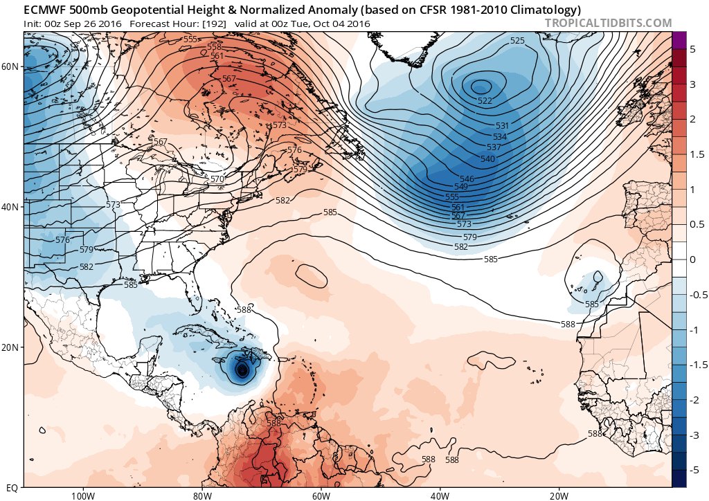
At 500mb if the center of the ridge to the N is being modeled correctly its too far West. It needs to be centered further E over Nova Scotia or even just off the Canadain coast to prevent an escape out to sea. The trough in the west looks too far away to capture it yet.

_________________
"In weather and in life, there's no winning and losing; there's only winning and learning."
WINTER 2012/2013 TOTALS 43.65"WINTER 2017/2018 TOTALS 62.85" WINTER 2022/2023 TOTALS 4.9"
WINTER 2013/2014 TOTALS 64.85"WINTER 2018/2019 TOTALS 14.25" WINTER 2023/2024 TOTALS 13.1"
WINTER 2014/2015 TOTALS 71.20"WINTER 2019/2020 TOTALS 6.35"
WINTER 2015/2016 TOTALS 35.00"WINTER 2020/2021 TOTALS 37.75"
WINTER 2016/2017 TOTALS 42.25"WINTER 2021/2022 TOTALS 31.65"

sroc4- Admin

- Posts : 8331
Reputation : 301
Join date : 2013-01-07
Location : Wading River, LI
Re: 2016 Tropical Cyclone Discussions
![]() by sroc4 Mon Sep 26, 2016 2:22 pm
by sroc4 Mon Sep 26, 2016 2:22 pm
jmanley32 wrote:what we're u trying to ask here? It being south is a good thing unless it plows into sa but so far there no solution showing that. Latest intensity models have it a ts in 36 hrs and ramps up over 5 days to as high as cat 2 to 5.oldtimer wrote:Isn't it to far south to delvelop at 8* lay??
That may happen but dont be surprised to see the timing of intensification to be pushed back by a few days at least.
_________________
"In weather and in life, there's no winning and losing; there's only winning and learning."
WINTER 2012/2013 TOTALS 43.65"WINTER 2017/2018 TOTALS 62.85" WINTER 2022/2023 TOTALS 4.9"
WINTER 2013/2014 TOTALS 64.85"WINTER 2018/2019 TOTALS 14.25" WINTER 2023/2024 TOTALS 13.1"
WINTER 2014/2015 TOTALS 71.20"WINTER 2019/2020 TOTALS 6.35"
WINTER 2015/2016 TOTALS 35.00"WINTER 2020/2021 TOTALS 37.75"
WINTER 2016/2017 TOTALS 42.25"WINTER 2021/2022 TOTALS 31.65"
sroc4- Admin
- Posts : 8331
Reputation : 301
Join date : 2013-01-07
Location : Wading River, LI
Re: 2016 Tropical Cyclone Discussions
![]() by jmanley32 Mon Sep 26, 2016 2:23 pm
by jmanley32 Mon Sep 26, 2016 2:23 pm
jmanley32- Senior Enthusiast
- Posts : 20513
Reputation : 108
Join date : 2013-12-12
Age : 42
Location : Yonkers, NY
Re: 2016 Tropical Cyclone Discussions
![]() by jmanley32 Mon Sep 26, 2016 2:41 pm
by jmanley32 Mon Sep 26, 2016 2:41 pm
jmanley32- Senior Enthusiast
- Posts : 20513
Reputation : 108
Join date : 2013-12-12
Age : 42
Location : Yonkers, NY
Re: 2016 Tropical Cyclone Discussions
![]() by jmanley32 Mon Sep 26, 2016 3:03 pm
by jmanley32 Mon Sep 26, 2016 3:03 pm
jmanley32- Senior Enthusiast
- Posts : 20513
Reputation : 108
Join date : 2013-12-12
Age : 42
Location : Yonkers, NY
Re: 2016 Tropical Cyclone Discussions
![]() by skinsfan1177 Mon Sep 26, 2016 3:11 pm
by skinsfan1177 Mon Sep 26, 2016 3:11 pm
jmanley32 wrote:Euro still ends up in similar spot headed NW or NNW, reading there is a trough coming in that could make this a sandy-esq run could it go out further (not saying this would be sandy just what I am reading on tropics forums, some comments people make are not too smart though let me tell u). 12z CMC is very close to hitting us.
What forums Jman?

skinsfan1177- Senior Enthusiast
- Posts : 4485
Reputation : 35
Join date : 2013-01-07
Age : 46
Location : Point Pleasant Boro
Re: 2016 Tropical Cyclone Discussions
![]() by algae888 Mon Sep 26, 2016 3:16 pm
by algae888 Mon Sep 26, 2016 3:16 pm

algae888- Advanced Forecaster
- Posts : 5311
Reputation : 46
Join date : 2013-02-05
Age : 61
Location : mt. vernon, new york
Re: 2016 Tropical Cyclone Discussions
![]() by amugs Mon Sep 26, 2016 3:20 pm
by amugs Mon Sep 26, 2016 3:20 pm
Lots of time and we must learn that they depicted such for Hermine and it got 75 more east than modelled
_________________
Mugs
AKA:King: Snow Weenie
Self Proclaimed
WINTER 2014-15 : 55.12" +.02 for 6 coatings (avg. 35")
WINTER 2015-16 Total - 29.8" (Avg 35")
WINTER 2016-17 : 39.5" so far
amugs- Advanced Forecaster - Mod
- Posts : 15093
Reputation : 213
Join date : 2013-01-07
Age : 54
Location : Hillsdale,NJ
Re: 2016 Tropical Cyclone Discussions
![]() by amugs Mon Sep 26, 2016 3:21 pm
by amugs Mon Sep 26, 2016 3:21 pm
Scary Scenario.
_________________
Mugs
AKA:King: Snow Weenie
Self Proclaimed
WINTER 2014-15 : 55.12" +.02 for 6 coatings (avg. 35")
WINTER 2015-16 Total - 29.8" (Avg 35")
WINTER 2016-17 : 39.5" so far
amugs- Advanced Forecaster - Mod
- Posts : 15093
Reputation : 213
Join date : 2013-01-07
Age : 54
Location : Hillsdale,NJ
Re: 2016 Tropical Cyclone Discussions
![]() by algae888 Mon Sep 26, 2016 3:23 pm
by algae888 Mon Sep 26, 2016 3:23 pm
algae888- Advanced Forecaster
- Posts : 5311
Reputation : 46
Join date : 2013-02-05
Age : 61
Location : mt. vernon, new york
Re: 2016 Tropical Cyclone Discussions
![]() by algae888 Mon Sep 26, 2016 3:25 pm
by algae888 Mon Sep 26, 2016 3:25 pm
algae888- Advanced Forecaster
- Posts : 5311
Reputation : 46
Join date : 2013-02-05
Age : 61
Location : mt. vernon, new york
Re: 2016 Tropical Cyclone Discussions
![]() by skinsfan1177 Mon Sep 26, 2016 3:31 pm
by skinsfan1177 Mon Sep 26, 2016 3:31 pm
skinsfan1177- Senior Enthusiast
- Posts : 4485
Reputation : 35
Join date : 2013-01-07
Age : 46
Location : Point Pleasant Boro
Re: 2016 Tropical Cyclone Discussions
![]() by nutleyblizzard Mon Sep 26, 2016 3:41 pm
by nutleyblizzard Mon Sep 26, 2016 3:41 pm
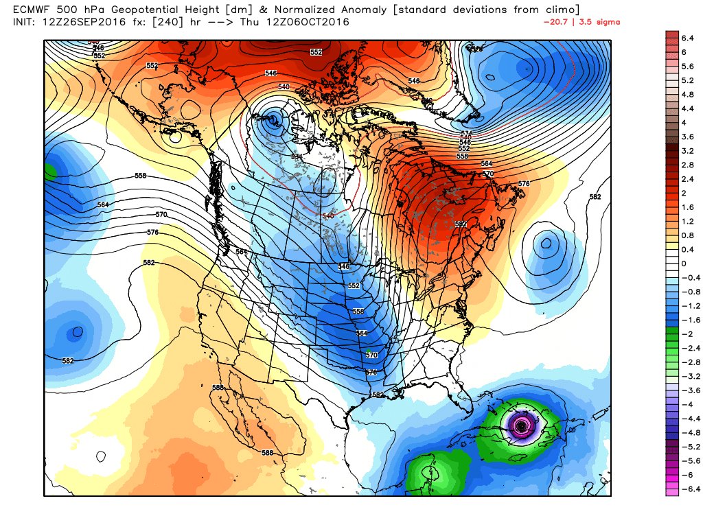
If one wants to see a devastating hit by a major hurricane along the east coast, you need to see a slower moving storm like the EURO depicts. In doing so it misses the first trough and would of surely shown a capture/phase with the second deep trough approaching if the model run would of continued. On the other hand, you have a faster moving storm on the GFS thus an OTS solution. Its all about timing and things should become much clearer by this weekend.amugs wrote:Difference is what I have showed in my post yesterday that SIR SROC (love that medieval style name) pointed to. Euro 500mb pattern - the trough in the west/midwest is deep and HP raised height sare over SE CAN - block the storm from barreling OTS - 1034 HP is a stout ridge.
Lots of time and we must learn that they depicted such for Hermine and it got 75 more east than modelled

nutleyblizzard- Senior Enthusiast
- Posts : 1952
Reputation : 41
Join date : 2014-01-30
Age : 58
Location : Nutley, new jersey
Re: 2016 Tropical Cyclone Discussions
![]() by jmanley32 Mon Sep 26, 2016 3:42 pm
by jmanley32 Mon Sep 26, 2016 3:42 pm
jmanley32- Senior Enthusiast
- Posts : 20513
Reputation : 108
Join date : 2013-12-12
Age : 42
Location : Yonkers, NY
Page 28 of 33 • 1 ... 15 ... 27, 28, 29 ... 33 ![]()
|
|
|