
 Search
HURRICANE MATTHEW
Page 11 of 32 •  1 ... 7 ... 10, 11, 12 ... 21 ... 32
 ![]()
Re: HURRICANE MATTHEW
![]() by skinsfan1177 Wed Sep 28, 2016 6:37 pm
by skinsfan1177 Wed Sep 28, 2016 6:37 pm
skinsfan1177- Senior Enthusiast

- Posts : 4485
Join date : 2013-01-07
Re: HURRICANE MATTHEW
![]() by Frank_Wx Wed Sep 28, 2016 6:40 pm
by Frank_Wx Wed Sep 28, 2016 6:40 pm
skinsfan1177 wrote:People writing it off on another weather board it's crazy this thing will change 100 times ugh!
Remember Hermine? Couldn't get that ***** right within 48 hours let alone 10 days out
Frank_Wx- Godzilla Seeker

- Posts : 21305
Join date : 2013-01-05 -

Re: HURRICANE MATTHEW
![]() by algae888 Wed Sep 28, 2016 6:43 pm
by algae888 Wed Sep 28, 2016 6:43 pm
Your right skins can't write this off. Some land mass somewhere is going to be affected by Matthew it's happened already. The more likely ones are the Western Caribbean islands Florida into North Carolina that's where hurricanes often hit. To have an extreme Sandy like run for our area is extremely rare and the odds that Matthew takes a track like that are Slim No matter which model shows a solution like that this far outskinsfan1177 wrote:People writing it off on another weather board it's crazy this thing will change 100 times ugh!

algae888- Advanced Forecaster

- Posts : 5311
Reputation : 46
Join date : 2013-02-05
Age : 61
Location : mt. vernon, new york
Re: HURRICANE MATTHEW
![]() by amugs Wed Sep 28, 2016 6:46 pm
by amugs Wed Sep 28, 2016 6:46 pm
The friggin storm is about 120 miles off the coast - jeez that is a sneeze this far out even within 12 hours for god's sake.
Time for some dinner.
_________________
Mugs
AKA:King: Snow Weenie
Self Proclaimed
WINTER 2014-15 : 55.12" +.02 for 6 coatings (avg. 35")
WINTER 2015-16 Total - 29.8" (Avg 35")
WINTER 2016-17 : 39.5" so far

amugs- Advanced Forecaster - Mod

- Posts : 15093
Reputation : 213
Join date : 2013-01-07
Age : 54
Location : Hillsdale,NJ

jmanley32- Senior Enthusiast
- Posts : 20516
Reputation : 108
Join date : 2013-12-12
Age : 42
Location : Yonkers, NY
Re: HURRICANE MATTHEW
![]() by jmanley32 Wed Sep 28, 2016 7:42 pm
by jmanley32 Wed Sep 28, 2016 7:42 pm
we don't need a sandy type landfall to have a bad hurricane.algae888 wrote:Your right skins can't write this off. Some land mass somewhere is going to be affected by Matthew it's happened already. The more likely ones are the Western Caribbean islands Florida into North Carolina that's where hurricanes often hit. To have an extreme Sandy like run for our area is extremely rare and the odds that Matthew takes a track like that are Slim No matter which model shows a solution like that this far outskinsfan1177 wrote:People writing it off on another weather board it's crazy this thing will change 100 times ugh!
jmanley32- Senior Enthusiast
- Posts : 20516
Reputation : 108
Join date : 2013-12-12
Age : 42
Location : Yonkers, NY
Re: HURRICANE MATTHEW
![]() by algae888 Wed Sep 28, 2016 7:42 pm
by algae888 Wed Sep 28, 2016 7:42 pm

https://pbs.twimg.com/tweet_video_thumb/CteSFhgXYAESbfG.jpg
video not coming up oh well it is pretty cool to see.
Last edited by algae888 on Wed Sep 28, 2016 7:55 pm; edited 2 times in total
algae888- Advanced Forecaster
- Posts : 5311
Reputation : 46
Join date : 2013-02-05
Age : 61
Location : mt. vernon, new york
Re: HURRICANE MATTHEW
![]() by algae888 Wed Sep 28, 2016 7:49 pm
by algae888 Wed Sep 28, 2016 7:49 pm
I know jman. just stating it's unlikely to have major hurricanes up this way. they happen but not very often.jmanley32 wrote:we don't need a sandy type landfall to have a bad hurricane.algae888 wrote:Your right skins can't write this off. Some land mass somewhere is going to be affected by Matthew it's happened already. The more likely ones are the Western Caribbean islands Florida into North Carolina that's where hurricanes often hit. To have an extreme Sandy like run for our area is extremely rare and the odds that Matthew takes a track like that are Slim No matter which model shows a solution like that this far outskinsfan1177 wrote:People writing it off on another weather board it's crazy this thing will change 100 times ugh!
algae888- Advanced Forecaster
- Posts : 5311
Reputation : 46
Join date : 2013-02-05
Age : 61
Location : mt. vernon, new york
Re: HURRICANE MATTHEW
![]() by jmanley32 Wed Sep 28, 2016 7:49 pm
by jmanley32 Wed Sep 28, 2016 7:49 pm
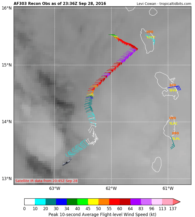
Location: 13.9°N 62.4°W
Moving: W at 15 mph
Min pressure: 1004 mb
Max sustained: 65 mph
10mph away from being a hurricane. Not having much trouble strengthening so far and NHC calling for continued increase in intensity.
jmanley32- Senior Enthusiast
- Posts : 20516
Reputation : 108
Join date : 2013-12-12
Age : 42
Location : Yonkers, NY
Re: HURRICANE MATTHEW
![]() by jmanley32 Wed Sep 28, 2016 7:52 pm
by jmanley32 Wed Sep 28, 2016 7:52 pm
algae888 wrote:I know jman. just stating it's unlikely to have major hurricanes up this way. they happen but not very often.jmanley32 wrote:we don't need a sandy type landfall to have a bad hurricane.algae888 wrote:Your right skins can't write this off. Some land mass somewhere is going to be affected by Matthew it's happened already. The more likely ones are the Western Caribbean islands Florida into North Carolina that's where hurricanes often hit. To have an extreme Sandy like run for our area is extremely rare and the odds that Matthew takes a track like that are Slim No matter which model shows a solution like that this far outskinsfan1177 wrote:People writing it off on another weather board it's crazy this thing will change 100 times ugh!
Even a TS or Cat 1 would be bad enough, I understood what you were saying, to add a sandy like track would make it even less likely, i see a regular track most likely if we do get anything.
jmanley32- Senior Enthusiast
- Posts : 20516
Reputation : 108
Join date : 2013-12-12
Age : 42
Location : Yonkers, NY
Re: HURRICANE MATTHEW
![]() by nutleyblizzard Wed Sep 28, 2016 8:08 pm
by nutleyblizzard Wed Sep 28, 2016 8:08 pm
Matthew is looking better organized this evening. Great outflow in all quadrants. I feel it won't be much longer before we see Hurricane Matthew.

nutleyblizzard- Senior Enthusiast
- Posts : 1952
Reputation : 41
Join date : 2014-01-30
Age : 58
Location : Nutley, new jersey
Re: HURRICANE MATTHEW
![]() by jmanley32 Wed Sep 28, 2016 8:16 pm
by jmanley32 Wed Sep 28, 2016 8:16 pm
looks good
jmanley32- Senior Enthusiast
- Posts : 20516
Reputation : 108
Join date : 2013-12-12
Age : 42
Location : Yonkers, NY
Re: HURRICANE MATTHEW
![]() by jmanley32 Wed Sep 28, 2016 8:19 pm
by jmanley32 Wed Sep 28, 2016 8:19 pm
jmanley32- Senior Enthusiast
- Posts : 20516
Reputation : 108
Join date : 2013-12-12
Age : 42
Location : Yonkers, NY
Re: HURRICANE MATTHEW
![]() by nutleyblizzard Wed Sep 28, 2016 8:21 pm
by nutleyblizzard Wed Sep 28, 2016 8:21 pm
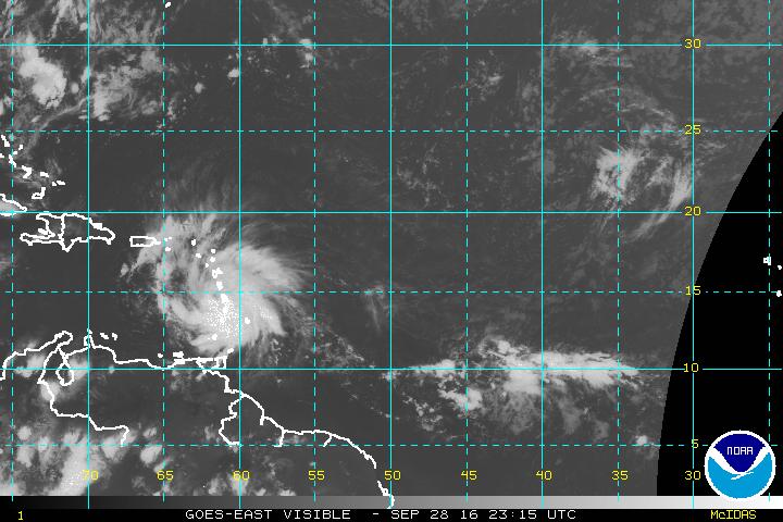
The official forecast is for Matthew to attain hurricane status early Friday morning. From the looks of satellite imagery, it may very well be tomorrow morning.jmanley32 wrote:http://www.ssd.noaa.gov/PS/TROP/floaters/14L/html5-rb-short.html
looks good
nutleyblizzard- Senior Enthusiast
- Posts : 1952
Reputation : 41
Join date : 2014-01-30
Age : 58
Location : Nutley, new jersey
Re: HURRICANE MATTHEW
![]() by sroc4 Wed Sep 28, 2016 8:25 pm
by sroc4 Wed Sep 28, 2016 8:25 pm
nutleyblizzard wrote:The official forecast is for Matthew to attain hurricane status early Friday morning. From the looks of satellite imagery, it may very well be tomorrow morning.jmanley32 wrote:http://www.ssd.noaa.gov/PS/TROP/floaters/14L/html5-rb-short.html
looks good
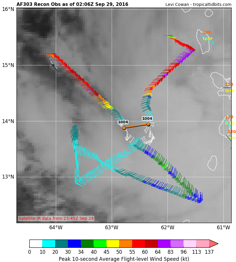
Levis latest update.
http://www.tropicaltidbits.com
_________________
"In weather and in life, there's no winning and losing; there's only winning and learning."
WINTER 2012/2013 TOTALS 43.65"WINTER 2017/2018 TOTALS 62.85" WINTER 2022/2023 TOTALS 4.9"
WINTER 2013/2014 TOTALS 64.85"WINTER 2018/2019 TOTALS 14.25" WINTER 2023/2024 TOTALS 13.1"
WINTER 2014/2015 TOTALS 71.20"WINTER 2019/2020 TOTALS 6.35"
WINTER 2015/2016 TOTALS 35.00"WINTER 2020/2021 TOTALS 37.75"
WINTER 2016/2017 TOTALS 42.25"WINTER 2021/2022 TOTALS 31.65"

sroc4- Admin
- Posts : 8331
Reputation : 301
Join date : 2013-01-07
Location : Wading River, LI
Re: HURRICANE MATTHEW
![]() by hyde345 Wed Sep 28, 2016 8:39 pm
by hyde345 Wed Sep 28, 2016 8:39 pm
sroc4 wrote:nutleyblizzard wrote:The official forecast is for Matthew to attain hurricane status early Friday morning. From the looks of satellite imagery, it may very well be tomorrow morning.jmanley32 wrote:http://www.ssd.noaa.gov/PS/TROP/floaters/14L/html5-rb-short.html
looks good
Levis latest update.
http://www.tropicaltidbits.com
Thanks for posting that. Very Informative.

hyde345- Pro Enthusiast

- Posts : 1082
Reputation : 48
Join date : 2013-01-08
Location : Hyde Park, NY
Re: HURRICANE MATTHEW
![]() by jmanley32 Wed Sep 28, 2016 10:04 pm
by jmanley32 Wed Sep 28, 2016 10:04 pm
jmanley32- Senior Enthusiast
- Posts : 20516
Reputation : 108
Join date : 2013-12-12
Age : 42
Location : Yonkers, NY
Re: HURRICANE MATTHEW
![]() by jmanley32 Wed Sep 28, 2016 10:15 pm
by jmanley32 Wed Sep 28, 2016 10:15 pm
jmanley32- Senior Enthusiast
- Posts : 20516
Reputation : 108
Join date : 2013-12-12
Age : 42
Location : Yonkers, NY
Re: HURRICANE MATTHEW
![]() by devsman Wed Sep 28, 2016 10:47 pm
by devsman Wed Sep 28, 2016 10:47 pm

devsman- Pro Enthusiast
- Posts : 424
Reputation : 4
Join date : 2014-01-01
Age : 48
Location : merrick, ny (south shore of Long Island)
Re: HURRICANE MATTHEW
![]() by jmanley32 Wed Sep 28, 2016 11:09 pm
by jmanley32 Wed Sep 28, 2016 11:09 pm
jmanley32- Senior Enthusiast
- Posts : 20516
Reputation : 108
Join date : 2013-12-12
Age : 42
Location : Yonkers, NY
Re: HURRICANE MATTHEW
![]() by Snow88 Thu Sep 29, 2016 12:29 am
by Snow88 Thu Sep 29, 2016 12:29 am

Snow88- Senior Enthusiast
- Posts : 2193
Reputation : 4
Join date : 2013-01-09
Age : 35
Location : Brooklyn, NY
Re: HURRICANE MATTHEW
![]() by jmanley32 Thu Sep 29, 2016 12:35 am
by jmanley32 Thu Sep 29, 2016 12:35 am
Snow88 wrote:Trough too slow on this run . Onto the ensembles.
Its damn close though, then GFS is steadfast on a very close pass if not landfall on the area, though it has been east at the last minute past few runs.
jmanley32- Senior Enthusiast
- Posts : 20516
Reputation : 108
Join date : 2013-12-12
Age : 42
Location : Yonkers, NY
Re: HURRICANE MATTHEW
![]() by Snow88 Thu Sep 29, 2016 1:11 am
by Snow88 Thu Sep 29, 2016 1:11 am
http://www.stormvistawxmodels.com/img/cmc/current/00z/CMC_MSLPThickQPF_na_f162.png?1364096147
http://www.stormvistawxmodels.com/img/cmc/current/00z/CMC_MSLPThickQPF_na_f165.png?1364096147
http://www.stormvistawxmodels.com/img/cmc/current/00z/CMC_MSLPThickQPF_na_f168.png?1364096147
http://www.stormvistawxmodels.com/img/cmc/current/00z/CMC_MSLPThickQPF_na_f171.png?1364096147
Snow88- Senior Enthusiast
- Posts : 2193
Reputation : 4
Join date : 2013-01-09
Age : 35
Location : Brooklyn, NY
Re: HURRICANE MATTHEW
![]() by jmanley32 Thu Sep 29, 2016 6:21 am
by jmanley32 Thu Sep 29, 2016 6:21 am
Also cone shifted east a bit and faster Haiti is really go b u dr the gun. Edit...if the euro went out further in hearing it might b ots? I see no sign of that shift at 240. My bad ot does appear to.jog ne at 240 hrs. Would that continue?
Last edited by jmanley32 on Thu Sep 29, 2016 6:42 am; edited 2 times in total
jmanley32- Senior Enthusiast
- Posts : 20516
Reputation : 108
Join date : 2013-12-12
Age : 42
Location : Yonkers, NY
Re: HURRICANE MATTHEW
![]() by sroc4 Thu Sep 29, 2016 6:23 am
by sroc4 Thu Sep 29, 2016 6:23 am
TROPICAL STORM MATTHEW DISCUSSION NUMBER 4
NWS NATIONAL HURRICANE CENTER MIAMI FL AL142016
500 AM AST THU SEP 29 2016
Matthew is currently experiencing 15-20 kt of southwesterly
vertical wind shear, with the low-level center located near the
western edge of the main convective mass. An earlier Air Force
Reserve Hurricane Hunter mission reported 850 mb flight-level winds
of 65-70 kt and estimated surface winds of 50-55 kt from the SFMR
instrument. Based on these data, the initial intensity remains 55
kt. The aircraft reported a central pressure of 1002 mb on its
last pass through the center.
The initial motion is 275/14. Matthew is currently on the south
side of a low- to mid-level subtropical ridge. This feature should
steer the storm westward or even south of west during the next 48
hours. After that time, Matthew is expected to approach the
western end of the ridge as a mid- to upper-level trough develops
over the Gulf of Mexico. While this combination is expected to
cause the cyclone to turn generally northward, there is significant
disagreement between the dynamical models on where the turn will
occur and how fast Matthew will move northward. The forecast track
is in best agreement with the GFS and GFS ensemble mean in bringing
the center to eastern Cuba by 120 hours, although it is slower than
those models. The Canadian model is a little west of the forecast
track. The ECMWF and UKMET are to the east of the forecast track and
much slower, bringing the center to the island of Hispaniola.
Overall, the new forecast track is nudged a little south of the
previous track for the first 72 hours, then is similar to the
previous track. Users are reminded that the average NHC track
errors at days 4 and 5 are on the order of 180 and 240 miles,
respectively.
The current shear is likely to gradually diminish during the next
72 hours, and this should allow continued gradual development.
After that time, there is also disagreement in the models regarding
the forecast shear, with the GFS showing a more favorable pattern
than the ECMWF. If the GFS upper-level winds are correct, Matthew
could strengthen more than currently forecast as show by the HWRF.
However, given the uncertainty, the new intensity forecast is the
same as the previous forecast and is in best agreement with the
intensity consensus.
_________________
"In weather and in life, there's no winning and losing; there's only winning and learning."
WINTER 2012/2013 TOTALS 43.65"WINTER 2017/2018 TOTALS 62.85" WINTER 2022/2023 TOTALS 4.9"
WINTER 2013/2014 TOTALS 64.85"WINTER 2018/2019 TOTALS 14.25" WINTER 2023/2024 TOTALS 13.1"
WINTER 2014/2015 TOTALS 71.20"WINTER 2019/2020 TOTALS 6.35"
WINTER 2015/2016 TOTALS 35.00"WINTER 2020/2021 TOTALS 37.75"
WINTER 2016/2017 TOTALS 42.25"WINTER 2021/2022 TOTALS 31.65"
sroc4- Admin
- Posts : 8331
Reputation : 301
Join date : 2013-01-07
Location : Wading River, LI
Re: HURRICANE MATTHEW
![]() by jmanley32 Thu Sep 29, 2016 6:40 am
by jmanley32 Thu Sep 29, 2016 6:40 am
jmanley32- Senior Enthusiast
- Posts : 20516
Reputation : 108
Join date : 2013-12-12
Age : 42
Location : Yonkers, NY
Re: HURRICANE MATTHEW
![]() by nutleyblizzard Thu Sep 29, 2016 7:00 am
by nutleyblizzard Thu Sep 29, 2016 7:00 am
In recent runs the GFS has been trending stronger with the western Atlantic ridge (war), thus the shift west. If you loop out the GFS 0z and 6z runs you can see once Matthew reaches the latitude of North Carolina it slows down and meanders for a while before it moves out NE. With the slightly slower movement of Matthew, 6z run came pretty close to a capture with the trough on its heels. If this trend continues with the slower movement / stronger ridge, we could very well see a capture in future runs.jmanley32 wrote:06z gfs is well west again gets close enough to give us outer areas of the storm. Ts conditions. To me this is looking like more and more of a threat but I'm still cautious that it's far out.
nutleyblizzard- Senior Enthusiast
- Posts : 1952
Reputation : 41
Join date : 2014-01-30
Age : 58
Location : Nutley, new jersey
Page 11 of 32 • 1 ... 7 ... 10, 11, 12 ... 21 ... 32 ![]()
|
|
|