
 Search
Long Range Thread 12.0
Page 13 of 40 •  1 ... 8 ... 12, 13, 14 ... 26 ... 40
 ![]()
Re: Long Range Thread 12.0
![]() by amugs Wed Oct 26, 2016 9:29 pm
by amugs Wed Oct 26, 2016 9:29 pm
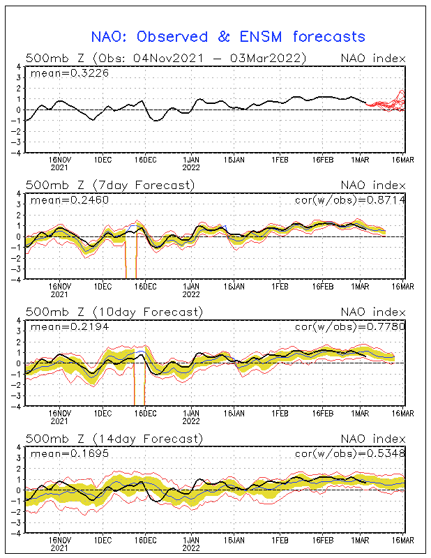
See that BIG blue circular trough South of the Aleutian Islands? As winter goes on that should retrograde more west allowing for the heights to rise over Alaska giving us a Neg EPO and +PNA which will help drive our winter. This is a seasonal atmospheric change in this region.
Look at the PNA spike and N AO setting up on those maps. Look at below that AO .
amugs- Advanced Forecaster - Mod

- Posts : 15093
Join date : 2013-01-07
amugs- Advanced Forecaster - Mod
- Posts : 15093
Join date : 2013-01-07
Re: Long Range Thread 12.0
![]() by Frank_Wx Wed Oct 26, 2016 9:47 pm
by Frank_Wx Wed Oct 26, 2016 9:47 pm
_________________
_______________________________________________________________________________________________________
CLICK HERE to view NJ Strong Snowstorm Classifications

Frank_Wx- Godzilla Seeker

- Posts : 21305
Reputation : 328
Join date : 2013-01-05
Age : 31
Location : Jersey City, NJ -

Re: Long Range Thread 12.0
![]() by amugs Wed Oct 26, 2016 9:54 pm
by amugs Wed Oct 26, 2016 9:54 pm

_________________
Mugs
AKA:King: Snow Weenie
Self Proclaimed
WINTER 2014-15 : 55.12" +.02 for 6 coatings (avg. 35")
WINTER 2015-16 Total - 29.8" (Avg 35")
WINTER 2016-17 : 39.5" so far

amugs- Advanced Forecaster - Mod
- Posts : 15093
Reputation : 213
Join date : 2013-01-07
Age : 54
Location : Hillsdale,NJ
Frank_Wx- Godzilla Seeker
- Posts : 21305
Reputation : 328
Join date : 2013-01-05
Age : 31
Location : Jersey City, NJ -
Re: Long Range Thread 12.0
![]() by amugs Wed Oct 26, 2016 10:16 pm
by amugs Wed Oct 26, 2016 10:16 pm
Frank_Wx wrote:If the Aleutian trough shown in the long range on the Ensembles is real, that will lock cold over the eastern U.S. beginning the week of November 6th. Since I will be in Nashville, TN between the 7th and 11th, expect the first significant snow of the season to occur then
Frank to this ENS are hinting at a BIG storm during this time frame - Archumbalt style with the transition. Time will tell.
_________________
Mugs
AKA:King: Snow Weenie
Self Proclaimed
WINTER 2014-15 : 55.12" +.02 for 6 coatings (avg. 35")
WINTER 2015-16 Total - 29.8" (Avg 35")
WINTER 2016-17 : 39.5" so far
amugs- Advanced Forecaster - Mod
- Posts : 15093
Reputation : 213
Join date : 2013-01-07
Age : 54
Location : Hillsdale,NJ
Re: Long Range Thread 12.0
![]() by algae888 Thu Oct 27, 2016 9:00 am
by algae888 Thu Oct 27, 2016 9:00 am


Last edited by algae888 on Thu Oct 27, 2016 9:03 am; edited 1 time in total

algae888- Advanced Forecaster

- Posts : 5311
Reputation : 46
Join date : 2013-02-05
Age : 61
Location : mt. vernon, new york


algae888- Advanced Forecaster
- Posts : 5311
Reputation : 46
Join date : 2013-02-05
Age : 61
Location : mt. vernon, new york
Re: Long Range Thread 12.0
![]() by rb924119 Thu Oct 27, 2016 9:52 am
by rb924119 Thu Oct 27, 2016 9:52 am
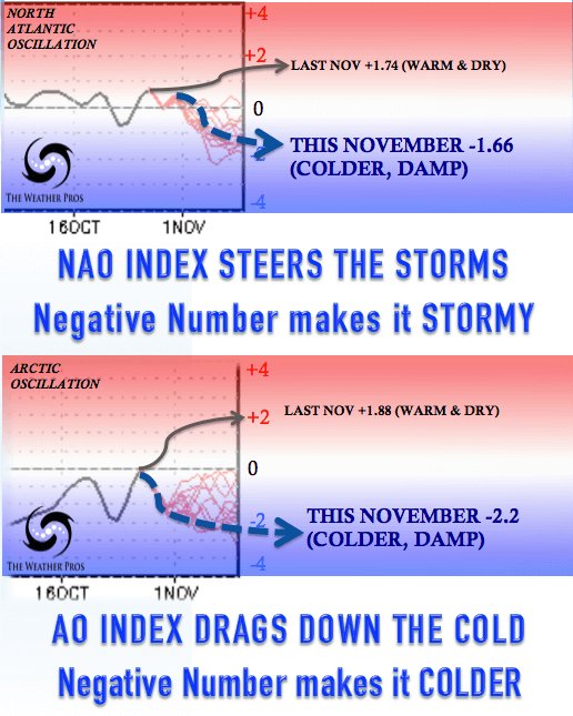
algae888 wrote:winter storm potential is next weekend. as we will have a -nao/ao and +pna. and I should say very neg!
YOU SON OF A GUN!!! YOU BEAT ME TO IT!!! I was just looking at this, although from a different perspective. But to know somebody else came to the same conclusion with a different method gives me hope haha I'll probably do a video on it later today haha
rb924119- Meteorologist

- Posts : 6890
Reputation : 194
Join date : 2013-02-06
Age : 32
Location : Greentown, Pa
Re: Long Range Thread 12.0
![]() by sroc4 Thu Oct 27, 2016 10:10 am
by sroc4 Thu Oct 27, 2016 10:10 am

_________________
"In weather and in life, there's no winning and losing; there's only winning and learning."
WINTER 2012/2013 TOTALS 43.65"WINTER 2017/2018 TOTALS 62.85" WINTER 2022/2023 TOTALS 4.9"
WINTER 2013/2014 TOTALS 64.85"WINTER 2018/2019 TOTALS 14.25" WINTER 2023/2024 TOTALS 13.1"
WINTER 2014/2015 TOTALS 71.20"WINTER 2019/2020 TOTALS 6.35"
WINTER 2015/2016 TOTALS 35.00"WINTER 2020/2021 TOTALS 37.75"
WINTER 2016/2017 TOTALS 42.25"WINTER 2021/2022 TOTALS 31.65"

sroc4- Admin
- Posts : 8331
Reputation : 301
Join date : 2013-01-07
Location : Wading River, LI
Re: Long Range Thread 12.0
![]() by algae888 Thu Oct 27, 2016 10:44 am
by algae888 Thu Oct 27, 2016 10:44 am
ummary
The Arctic Oscillation (AO) is currently negative and is predicted to remain negative over the next two weeks. The AO is predicted to first trend positive towards neutral and then reverse towards negative to possibly strongly negative the first half of November, with uncertainty in the AO becoming large the second week of November.
The current negative AO is reflective of positive pressure/geopotential height anomalies in the Arctic especially on the Eurasian side of the Arctic initially in the Barents-Kara seas and then breaking into two pieces with one piece sliding eastward into the East Siberian Sea. The North Atlantic Oscillation (NAO) is currently positive because of negative height anomalies near Greenland. However the NAO is predicted to trend negative the next two weeks as the second piece of the positive geopotential height anomalies in the Barents-Kara seas retrogrades towards Greenland.
With the AO firmly negative for the next two weeks, this favors below normal temperatures across large portions of northern Eurasia especially Siberia. In contrast, because North America will be dominated by mostly positive pressure/geopotential height anomalies, temperatures will average above normal much of next week in eastern North America. The following week with heights predicted to build once more near Greenland forcing the NAO into negative territory, lower geopotential heights and colder temperatures are predicted first for Europe and then for eastern North America for week two.
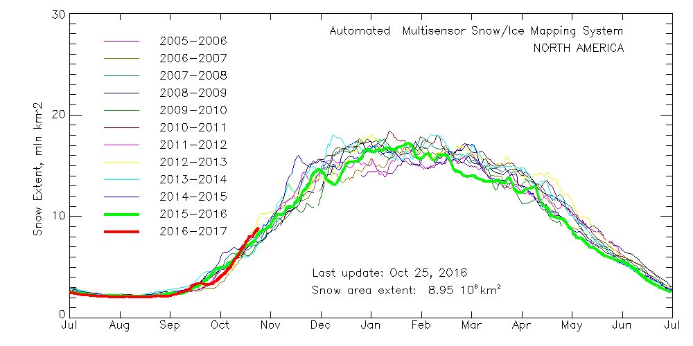
Eurasian snow cover is above normal and is continues to advance at a steady pace mostly across eastern Eurasia. However when the NAO flips negative, I expect a more rapid advance of snow cover westward towards Europe. High Eurasian snow cover and low Arctic sea ice in the Barents-Kara seas favor first, a strengthening Siberian high and then a weakened polar vortex (PV) in winter.
The stratospheric PV is predicted to significantly weaken into early November. All weather models now predict an unprecedented and significant early split of the stratospheric PV. I expect the circulation anomalies associated with the PV split to descend into the mid and lower troposphere later in November. When this occurs expect the cold and snow that has been mostly confined to Siberia so far, to expand into the mid-latitudes resulting in an early start to winter weather for widespread portions of northern Eurasia, including Europe and East Asia, and possibly the eastern United States (US).
algae888- Advanced Forecaster
- Posts : 5311
Reputation : 46
Join date : 2013-02-05
Age : 61
Location : mt. vernon, new york
Re: Long Range Thread 12.0
![]() by algae888 Thu Oct 27, 2016 10:53 am
by algae888 Thu Oct 27, 2016 10:53 am
https://www.aer.com/science-research/climate-weather/arctic-oscillation
Here is some more of the arcticle...
do believe that the large-scale atmospheric stratospheric circulation is nearly unprecedented for this time of year and a record weak PV s predicted by all the models during the first week of November. Since September, I have been focusing on the unusually weak stratospheric polar vortex so far this fall season and in my opinion the strength of the polar vortex in the coming weeks, both in the stratosphere and the troposphere, is key to this winter’s weather. With strong high pressure centered in the Barents Kara seas, the large-scale tropospheric pattern has been very favorable for poleward heat transport or vertical Wave Activity Flux (WAFz). Record strong poleward heat flux is predicted this week. This will result in a highly anomalous stratospheric PV split in the next seven to ten days. This early stratospheric PV split is possibly unprecedented in the observational record. I have so far not found a PV split so early in the season and if anyone can find one please let me know. If we were observing a record weak PV in early January, when it is more common, I would be writing about the strong potential for widespread and extended severe winter weather across the Northern Hemisphere. Instead I find myself expressing higher uncertainty not unlike the AO blogs early last spring trying to predict the consequences of an unprecedented late record weakening of the PV. However there is one important difference and that is the sun’s strength. Back in late March and early April, the sun was quite strong already and only getting stronger across the Northern Hemisphere (NH) mitigating the dynamical cooling forced by the PV split. Now we have the exact reverse situation with solar radiation already low across the NH and it is only getting weaker. I believe that the potential exists for snow cover and cold temperatures to become unusually expansive in the month of November and the dynamically forced cooling by the PV split will be amplified by the weakening solar radiation. An established snow cover and widespread cold temperatures will become increasingly difficult to dislodge and reverse especially across Eurasia as we approach the core winter months.
algae888- Advanced Forecaster
- Posts : 5311
Reputation : 46
Join date : 2013-02-05
Age : 61
Location : mt. vernon, new york
Re: Long Range Thread 12.0
![]() by amugs Thu Oct 27, 2016 11:13 am
by amugs Thu Oct 27, 2016 11:13 am
Okay lets do a winter contest like Frank did last year:
Over under on # of snow threads - my call 32 this year - we dont end till later March.
This is nice - a tad more south but we can work on that!!

_________________
Mugs
AKA:King: Snow Weenie
Self Proclaimed
WINTER 2014-15 : 55.12" +.02 for 6 coatings (avg. 35")
WINTER 2015-16 Total - 29.8" (Avg 35")
WINTER 2016-17 : 39.5" so far
amugs- Advanced Forecaster - Mod
- Posts : 15093
Reputation : 213
Join date : 2013-01-07
Age : 54
Location : Hillsdale,NJ
Re: Long Range Thread 12.0
![]() by amugs Thu Oct 27, 2016 11:24 am
by amugs Thu Oct 27, 2016 11:24 am
.png)
_________________
Mugs
AKA:King: Snow Weenie
Self Proclaimed
WINTER 2014-15 : 55.12" +.02 for 6 coatings (avg. 35")
WINTER 2015-16 Total - 29.8" (Avg 35")
WINTER 2016-17 : 39.5" so far
amugs- Advanced Forecaster - Mod
- Posts : 15093
Reputation : 213
Join date : 2013-01-07
Age : 54
Location : Hillsdale,NJ
Re: Long Range Thread 12.0
![]() by algae888 Thu Oct 27, 2016 11:46 am
by algae888 Thu Oct 27, 2016 11:46 am
Yes mugs just saw that it looks like all guidance is coming around to what the Euro weeklies have been showing. One thing is certain the pattern has definitely changed we are much more like a nino than a nina, as it has become very wet and looks to continue to be wet for the foreseeable future. Mugs as you have stated many times on here the nino lag effect. Some mets are even throwing out nina analogues. An active pattern with a strong polar jet fun times ahead.amugs wrote:JMA - posted this last week too - standing firm on the trough in the east weeks 3 and 4
algae888- Advanced Forecaster
- Posts : 5311
Reputation : 46
Join date : 2013-02-05
Age : 61
Location : mt. vernon, new york
Re: Long Range Thread 12.0
![]() by Quietace Thu Oct 27, 2016 12:44 pm
by Quietace Thu Oct 27, 2016 12:44 pm
Even here in the NE, the Whites, Greens, and the Daks are all covered in a few inches. Then Look at southern CA outside of the SLRV...Frank_Wx wrote:


Quietace- Meteorologist - Mod

- Posts : 3687
Reputation : 33
Join date : 2013-01-07
Age : 27
Location : Point Pleasant, NJ
Re: Long Range Thread 12.0
![]() by amugs Thu Oct 27, 2016 1:22 pm
by amugs Thu Oct 27, 2016 1:22 pm
algae888 wrote:Yes mugs just saw that it looks like all guidance is coming around to what the Euro weeklies have been showing. One thing is certain the pattern has definitely changed we are much more like a nino than a nina, as it has become very wet and looks to continue to be wet for the foreseeable future. Mugs as you have stated many times on here the nino lag effect. Some mets are even throwing out nina analogues. An active pattern with a strong polar jet fun times ahead.amugs wrote:JMA - posted this last week too - standing firm on the trough in the east weeks 3 and 4
Thanks Al and a weak Nino can be bang bang with the other variables if they come together IMHO. Can we mak eup for last year?? Remember that Nature has a way of BALANCING THINGS out in the long term
_________________
Mugs
AKA:King: Snow Weenie
Self Proclaimed
WINTER 2014-15 : 55.12" +.02 for 6 coatings (avg. 35")
WINTER 2015-16 Total - 29.8" (Avg 35")
WINTER 2016-17 : 39.5" so far
amugs- Advanced Forecaster - Mod
- Posts : 15093
Reputation : 213
Join date : 2013-01-07
Age : 54
Location : Hillsdale,NJ
Re: Long Range Thread 12.0
![]() by algae888 Thu Oct 27, 2016 3:54 pm
by algae888 Thu Oct 27, 2016 3:54 pm
algae888- Advanced Forecaster
- Posts : 5311
Reputation : 46
Join date : 2013-02-05
Age : 61
Location : mt. vernon, new york
Re: Long Range Thread 12.0
![]() by frank 638 Thu Oct 27, 2016 5:25 pm
by frank 638 Thu Oct 27, 2016 5:25 pm
frank 638- Senior Enthusiast

- Posts : 2824
Reputation : 37
Join date : 2016-01-01
Age : 40
Location : bronx ny
Re: Long Range Thread 12.0
![]() by sroc4 Thu Oct 27, 2016 7:25 pm
by sroc4 Thu Oct 27, 2016 7:25 pm
algae888 wrote:Strange evolution of systems on models today. Have them dropping south from Eastern Canada to off the New England coast. They're probably trying to get a handle on the blocking that's coming up in the next seven plus days.
Or blocking is being over modeled. Hopefully not but possibly.
_________________
"In weather and in life, there's no winning and losing; there's only winning and learning."
WINTER 2012/2013 TOTALS 43.65"WINTER 2017/2018 TOTALS 62.85" WINTER 2022/2023 TOTALS 4.9"
WINTER 2013/2014 TOTALS 64.85"WINTER 2018/2019 TOTALS 14.25" WINTER 2023/2024 TOTALS 13.1"
WINTER 2014/2015 TOTALS 71.20"WINTER 2019/2020 TOTALS 6.35"
WINTER 2015/2016 TOTALS 35.00"WINTER 2020/2021 TOTALS 37.75"
WINTER 2016/2017 TOTALS 42.25"WINTER 2021/2022 TOTALS 31.65"
sroc4- Admin
- Posts : 8331
Reputation : 301
Join date : 2013-01-07
Location : Wading River, LI
Re: Long Range Thread 12.0
![]() by algae888 Thu Oct 27, 2016 7:35 pm
by algae888 Thu Oct 27, 2016 7:35 pm
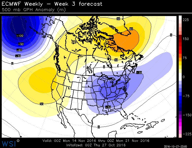
Mid NOV pattern flip on track: strong ECMWF weekly signal here, +PNA/-NAO and an eastern trough weeks 3/4
algae888- Advanced Forecaster
- Posts : 5311
Reputation : 46
Join date : 2013-02-05
Age : 61
Location : mt. vernon, new york
Re: Long Range Thread 12.0
![]() by sroc4 Thu Oct 27, 2016 7:39 pm
by sroc4 Thu Oct 27, 2016 7:39 pm
algae888 wrote:
Mid NOV pattern flip on track: strong ECMWF weekly signal here, +PNA/-NAO and an eastern trough weeks 3/4
Hey there gorgeous
_________________
"In weather and in life, there's no winning and losing; there's only winning and learning."
WINTER 2012/2013 TOTALS 43.65"WINTER 2017/2018 TOTALS 62.85" WINTER 2022/2023 TOTALS 4.9"
WINTER 2013/2014 TOTALS 64.85"WINTER 2018/2019 TOTALS 14.25" WINTER 2023/2024 TOTALS 13.1"
WINTER 2014/2015 TOTALS 71.20"WINTER 2019/2020 TOTALS 6.35"
WINTER 2015/2016 TOTALS 35.00"WINTER 2020/2021 TOTALS 37.75"
WINTER 2016/2017 TOTALS 42.25"WINTER 2021/2022 TOTALS 31.65"
sroc4- Admin
- Posts : 8331
Reputation : 301
Join date : 2013-01-07
Location : Wading River, LI
Re: Long Range Thread 12.0
![]() by amugs Thu Oct 27, 2016 7:55 pm
by amugs Thu Oct 27, 2016 7:55 pm

_________________
Mugs
AKA:King: Snow Weenie
Self Proclaimed
WINTER 2014-15 : 55.12" +.02 for 6 coatings (avg. 35")
WINTER 2015-16 Total - 29.8" (Avg 35")
WINTER 2016-17 : 39.5" so far
amugs- Advanced Forecaster - Mod
- Posts : 15093
Reputation : 213
Join date : 2013-01-07
Age : 54
Location : Hillsdale,NJ
Re: Long Range Thread 12.0
![]() by algae888 Fri Oct 28, 2016 2:06 pm
by algae888 Fri Oct 28, 2016 2:06 pm
algae888- Advanced Forecaster
- Posts : 5311
Reputation : 46
Join date : 2013-02-05
Age : 61
Location : mt. vernon, new york
Re: Long Range Thread 12.0
![]() by dkodgis Sat Oct 29, 2016 8:00 am
by dkodgis Sat Oct 29, 2016 8:00 am

dkodgis- Senior Enthusiast
- Posts : 2501
Reputation : 98
Join date : 2013-12-29
Re: Long Range Thread 12.0
![]() by weatherwatchermom Sat Oct 29, 2016 8:46 am
by weatherwatchermom Sat Oct 29, 2016 8:46 am

weatherwatchermom- Senior Enthusiast
- Posts : 3738
Reputation : 77
Join date : 2014-11-25
Age : 60
Location : Hazlet Township, NJ
Re: Long Range Thread 12.0
![]() by amugs Sat Oct 29, 2016 2:37 pm
by amugs Sat Oct 29, 2016 2:37 pm
_________________
Mugs
AKA:King: Snow Weenie
Self Proclaimed
WINTER 2014-15 : 55.12" +.02 for 6 coatings (avg. 35")
WINTER 2015-16 Total - 29.8" (Avg 35")
WINTER 2016-17 : 39.5" so far
amugs- Advanced Forecaster - Mod
- Posts : 15093
Reputation : 213
Join date : 2013-01-07
Age : 54
Location : Hillsdale,NJ
Page 13 of 40 • 1 ... 8 ... 12, 13, 14 ... 26 ... 40 ![]()
|
|
|