
 Search
Long Range Thread 12.0
Page 14 of 40 •  1 ... 8 ... 13, 14, 15 ... 27 ... 40
 ![]()
Re: Long Range Thread 12.0
![]() by weatherwatchermom Sat Oct 29, 2016 8:46 am
by weatherwatchermom Sat Oct 29, 2016 8:46 am
weatherwatchermom- Senior Enthusiast

- Posts : 3750
Join date : 2014-11-25
amugs- Advanced Forecaster - Mod

- Posts : 15093
Join date : 2013-01-07
Re: Long Range Thread 12.0
![]() by frank 638 Sat Oct 29, 2016 6:38 pm
by frank 638 Sat Oct 29, 2016 6:38 pm
frank 638- Senior Enthusiast
- Posts : 2825
Reputation : 37
Join date : 2016-01-01
Age : 40
Location : bronx ny
Re: Long Range Thread 12.0
![]() by amugs Sun Oct 30, 2016 12:34 pm
by amugs Sun Oct 30, 2016 12:34 pm
Atmospherical changes are coming by mid month with the possibility of a white coating on teh ground for turkey day but I will say this our chances increase significantly as December rolls up.

_________________
Mugs
AKA:King: Snow Weenie
Self Proclaimed
WINTER 2014-15 : 55.12" +.02 for 6 coatings (avg. 35")
WINTER 2015-16 Total - 29.8" (Avg 35")
WINTER 2016-17 : 39.5" so far

amugs- Advanced Forecaster - Mod
- Posts : 15093
Reputation : 213
Join date : 2013-01-07
Age : 54
Location : Hillsdale,NJ
Re: Long Range Thread 12.0
![]() by amugs Sun Oct 30, 2016 3:39 pm
by amugs Sun Oct 30, 2016 3:39 pm
There is a tremendous amount of latent heat from the super Nino and ++PDO we had and it has to go somewhere, much of it goes by way of poleward heat flux and when this happens, a winter following traditionally sees cold air near the surface taking the path of least resistance, (moving equatorward over land masses) and some areas seeing immense cold, especially with a -AO, the question is what side of the world sees it? North America, North America and Europe at the same time or just Asia....maybe all three with an active global circulation? Remember we have a weak walker cell/Kara high setup starting to unfold already.
_________________
Mugs
AKA:King: Snow Weenie
Self Proclaimed
WINTER 2014-15 : 55.12" +.02 for 6 coatings (avg. 35")
WINTER 2015-16 Total - 29.8" (Avg 35")
WINTER 2016-17 : 39.5" so far
amugs- Advanced Forecaster - Mod
- Posts : 15093
Reputation : 213
Join date : 2013-01-07
Age : 54
Location : Hillsdale,NJ
Re: Long Range Thread 12.0
![]() by amugs Mon Oct 31, 2016 12:29 pm
by amugs Mon Oct 31, 2016 12:29 pm

Control showing an EC storm

CFSv2 says HELLO!!! If these maps EVER verified I would have had 100" last year!!!!

_________________
Mugs
AKA:King: Snow Weenie
Self Proclaimed
WINTER 2014-15 : 55.12" +.02 for 6 coatings (avg. 35")
WINTER 2015-16 Total - 29.8" (Avg 35")
WINTER 2016-17 : 39.5" so far
amugs- Advanced Forecaster - Mod
- Posts : 15093
Reputation : 213
Join date : 2013-01-07
Age : 54
Location : Hillsdale,NJ
Re: Long Range Thread 12.0
![]() by amugs Mon Oct 31, 2016 12:45 pm
by amugs Mon Oct 31, 2016 12:45 pm

_________________
Mugs
AKA:King: Snow Weenie
Self Proclaimed
WINTER 2014-15 : 55.12" +.02 for 6 coatings (avg. 35")
WINTER 2015-16 Total - 29.8" (Avg 35")
WINTER 2016-17 : 39.5" so far
amugs- Advanced Forecaster - Mod
- Posts : 15093
Reputation : 213
Join date : 2013-01-07
Age : 54
Location : Hillsdale,NJ
Re: Long Range Thread 12.0
![]() by Frank_Wx Mon Oct 31, 2016 12:53 pm
by Frank_Wx Mon Oct 31, 2016 12:53 pm

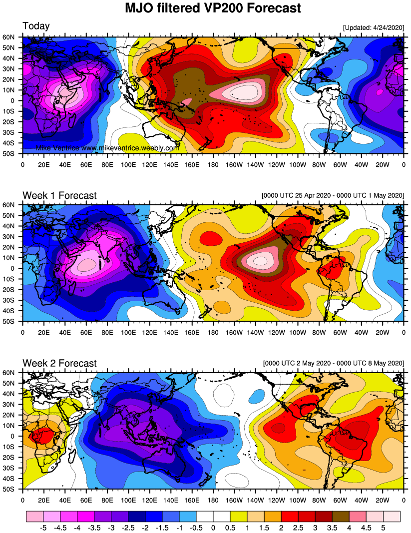
MJO is shown to get into favorable phases on both the GFS and ECM around that time frame.

It looks like the Stratospheric Wave 2 warming event will not be enough to split the PV at 10mb. We'll need another warming event (possibly arising from the tropical forcing mid-month) to do the job. Or we'll have to wait until mean zonal winds relax again.
_________________
_______________________________________________________________________________________________________
CLICK HERE to view NJ Strong Snowstorm Classifications

Frank_Wx- Godzilla Seeker

- Posts : 21305
Reputation : 328
Join date : 2013-01-05
Age : 31
Location : Jersey City, NJ -

Re: Long Range Thread 12.0
![]() by nutleyblizzard Mon Oct 31, 2016 12:53 pm
by nutleyblizzard Mon Oct 31, 2016 12:53 pm

nutleyblizzard- Senior Enthusiast
- Posts : 1952
Reputation : 41
Join date : 2014-01-30
Age : 58
Location : Nutley, new jersey
Re: Long Range Thread 12.0
![]() by Frank_Wx Mon Oct 31, 2016 12:56 pm
by Frank_Wx Mon Oct 31, 2016 12:56 pm
nutleyblizzard wrote:Thanks for the write up Frank. Good read, though I think you might be too low with snow totals for a couple of reasons. One is the impending pattern flip in mid to late November this year unlike the past couple of years where it took place in January. The other is the -NAO factor. Depending on how much we're in a negative phase, I can envision totals more in line with 40+ inches.
In the "what can go wrong" section I spoke about the NAO and how its a big wildcard (as it always is). If we get a sustained period of blocking that will increase snow totals. I think the reason why I am lower with snow totals is because I am having a hard time seeing us getting Godzilla or Roidzilla type events. I think we'll see a lot of light to moderate and thread the needles. Iv'e issues revised winter outlooks before so if I see major changes then this year won't be any different
_________________
_______________________________________________________________________________________________________
CLICK HERE to view NJ Strong Snowstorm Classifications
Frank_Wx- Godzilla Seeker
- Posts : 21305
Reputation : 328
Join date : 2013-01-05
Age : 31
Location : Jersey City, NJ -
Re: Long Range Thread 12.0
![]() by nutleyblizzard Mon Oct 31, 2016 1:10 pm
by nutleyblizzard Mon Oct 31, 2016 1:10 pm
Could be the snow weenie in me talking, but I can certainly see major snow potential this winter. Depending on how the anomalies align, if you have a split polar vortex over hudson bay along with bath water Atlantic SST's, all you need is a timed right shortwave to come along and then you have powder keg potential. Interesting times ahead.Frank_Wx wrote:nutleyblizzard wrote:Thanks for the write up Frank. Good read, though I think you might be too low with snow totals for a couple of reasons. One is the impending pattern flip in mid to late November this year unlike the past couple of years where it took place in January. The other is the -NAO factor. Depending on how much we're in a negative phase, I can envision totals more in line with 40+ inches.
In the "what can go wrong" section I spoke about the NAO and how its a big wildcard (as it always is). If we get a sustained period of blocking that will increase snow totals. I think the reason why I am lower with snow totals is because I am having a hard time seeing us getting Godzilla or Roidzilla type events. I think we'll see a lot of light to moderate and thread the needles. Iv'e issues revised winter outlooks before so if I see major changes then this year won't be any different
nutleyblizzard- Senior Enthusiast
- Posts : 1952
Reputation : 41
Join date : 2014-01-30
Age : 58
Location : Nutley, new jersey
Re: Long Range Thread 12.0
![]() by sroc4 Mon Oct 31, 2016 1:34 pm
by sroc4 Mon Oct 31, 2016 1:34 pm
Frank_Wx wrote:Re-curving typhoon in the west Pacific will revive tropical forcing later this weekend. Should lead to changes down the road for us, especially by the middle of November.
MJO is shown to get into favorable phases on both the GFS and ECM around that time frame.
It looks like the Stratospheric Wave 2 warming event will not be enough to split the PV at 10mb. We'll need another warming event (possibly arising from the tropical forcing mid-month) to do the job. Or we'll have to wait until mean zonal winds relax again.
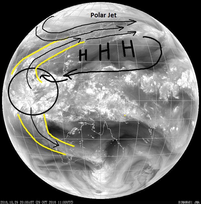
Currently tropical forcing, even though the MJO is currently in the "circle of death, is behaving more as if we are in a phase 3/4 as seen by a clear, albeit weak, influence on the polar westerly's on Sat imagery which I showed in my write up the other day. Image is from Oct 29th.
But the western edge of the elongated central Pac ridge is already showing the first signs of breaking down as seen by todays Sat loops.
http://www.goes.noaa.gov/dml/jma/fd/wvblue.html
If you look at the corrected GEFS and Euro MJO forecasts they both agree it will likely come out of the COD around phase 4/5 in the next few days before propagating eastward through 6-8. I am saving these images to follow along with how well these forecasts verify and or change over time. I personally need to see the stream, or atmospheric river of moisture, from the Equatorial tropics/subtropics into the polar westerly's turn off in the western IO, MJO phases 3/4, before I buy into the change in the pattern.


Recall last winter with a similar tropical forcing from these unfavorable MJO phases. Next image is from Jan 26th 2016. This was in large part the reason why myself and many others said that the atmosphere was not behaving like a typical strong El Nino, in large part because of these tropical forcings.
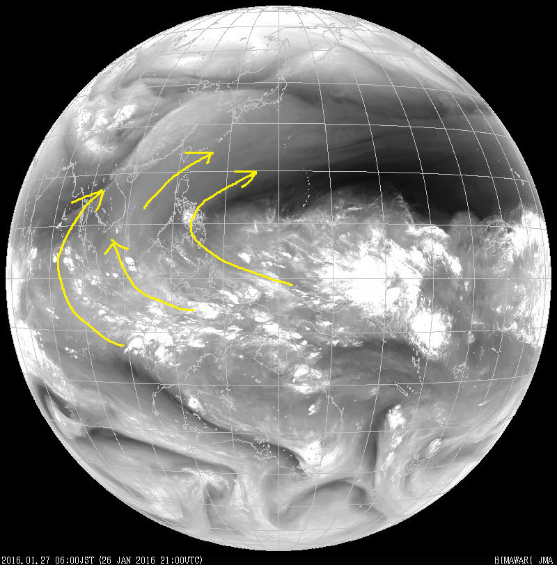
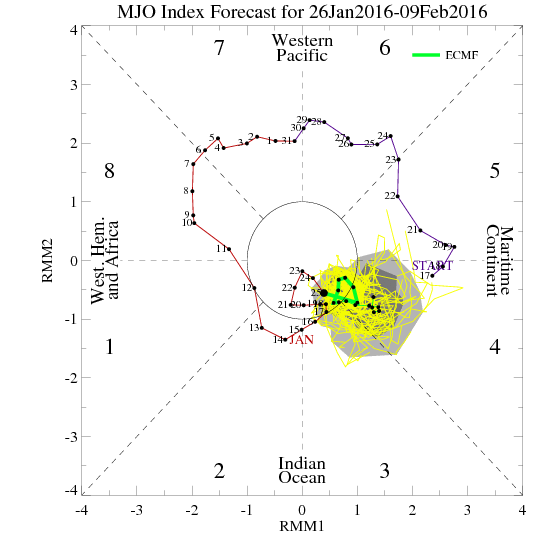
My point here is it took almost a month before we finally got the MJO to propagate into the colder phases for the EC, which if you recall we actually saw a brief period of record cold last Feb during this time frame. So again We need that area to turn off in the E IO, and re-establish itself closer to the dateline and hopefully if it does a feedback will occur allowing it to lock in and persistently enhance the Sub Aleutian trough.
_________________
"In weather and in life, there's no winning and losing; there's only winning and learning."
WINTER 2012/2013 TOTALS 43.65"WINTER 2017/2018 TOTALS 62.85" WINTER 2022/2023 TOTALS 4.9"
WINTER 2013/2014 TOTALS 64.85"WINTER 2018/2019 TOTALS 14.25" WINTER 2023/2024 TOTALS 13.1"
WINTER 2014/2015 TOTALS 71.20"WINTER 2019/2020 TOTALS 6.35"
WINTER 2015/2016 TOTALS 35.00"WINTER 2020/2021 TOTALS 37.75"
WINTER 2016/2017 TOTALS 42.25"WINTER 2021/2022 TOTALS 31.65"

sroc4- Admin
- Posts : 8331
Reputation : 301
Join date : 2013-01-07
Location : Wading River, LI
Re: Long Range Thread 12.0
![]() by amugs Mon Oct 31, 2016 1:42 pm
by amugs Mon Oct 31, 2016 1:42 pm
nutleyblizzard wrote:Could be the snow weenie in me talking, but I can certainly see major snow potential this winter. Depending on how the anomalies align, if you have a split polar vortex over hudson bay along with bath water Atlantic SST's, all you need is a timed right shortwave to come along and then you have powder keg potential. Interesting times ahead.Frank_Wx wrote:nutleyblizzard wrote:Thanks for the write up Frank. Good read, though I think you might be too low with snow totals for a couple of reasons. One is the impending pattern flip in mid to late November this year unlike the past couple of years where it took place in January. The other is the -NAO factor. Depending on how much we're in a negative phase, I can envision totals more in line with 40+ inches.
In the "what can go wrong" section I spoke about the NAO and how its a big wildcard (as it always is). If we get a sustained period of blocking that will increase snow totals. I think the reason why I am lower with snow totals is because I am having a hard time seeing us getting Godzilla or Roidzilla type events. I think we'll see a lot of light to moderate and thread the needles. Iv'e issues revised winter outlooks before so if I see major changes then this year won't be any different
Nutley,
There is the potential for such - Nada or weak nina have produced some Godzilla snows in the past (78,96,03 examples)not as much as Nino but there have been some - the Kara Straights/Sea may hold a key to the NAO this winter IMO. Also, if you read on here I posted a pro forecasters idea that all of the Heat from this Nno was transferred up to the arctic region tus helping the EPO and the AO. Interesting times ahead!
_________________
Mugs
AKA:King: Snow Weenie
Self Proclaimed
WINTER 2014-15 : 55.12" +.02 for 6 coatings (avg. 35")
WINTER 2015-16 Total - 29.8" (Avg 35")
WINTER 2016-17 : 39.5" so far
amugs- Advanced Forecaster - Mod
- Posts : 15093
Reputation : 213
Join date : 2013-01-07
Age : 54
Location : Hillsdale,NJ
Re: Long Range Thread 12.0
![]() by Dunnzoo Mon Oct 31, 2016 3:54 pm
by Dunnzoo Mon Oct 31, 2016 3:54 pm
nutleyblizzard wrote:Depending on how the anomalies align, if you have a split polar vortex over hudson bay along with bath water Atlantic SST's, all you need is a timed right shortwave to come along and then you have powder keg potential. Interesting times ahead.
oy vey! Those words cause us to lose too much sleep! Give me a good clipper that I can see coming way ahead of time!
_________________
Janet
Snowfall winter of 2023-2024 17.5"
Snowfall winter of 2022-2023 6.0"
Snowfall winter of 2021-2022 17.6" 1" sleet 2/25/22
Snowfall winter of 2020-2021 51.1"
Snowfall winter of 2019-2020 8.5"
Snowfall winter of 2018-2019 25.1"
Snowfall winter of 2017-2018 51.9"
Snowfall winter of 2016-2017 45.6"
Snowfall winter of 2015-2016 29.5"
Snowfall winter of 2014-2015 50.55"
Snowfall winter of 2013-2014 66.5"

Dunnzoo- Senior Enthusiast - Mod
- Posts : 4892
Reputation : 68
Join date : 2013-01-11
Age : 62
Location : Westwood, NJ
Re: Long Range Thread 12.0
![]() by algae888 Mon Oct 31, 2016 8:11 pm
by algae888 Mon Oct 31, 2016 8:11 pm
ryan maue

So the 2nd half of November is going to be really cold. Upgrade to ECMWF monthly (46-day) forecasts w/improved ocean model

algae888- Advanced Forecaster

- Posts : 5311
Reputation : 46
Join date : 2013-02-05
Age : 61
Location : mt. vernon, new york
Re: Long Range Thread 12.0
![]() by algae888 Mon Oct 31, 2016 8:12 pm
by algae888 Mon Oct 31, 2016 8:12 pm
algae888- Advanced Forecaster
- Posts : 5311
Reputation : 46
Join date : 2013-02-05
Age : 61
Location : mt. vernon, new york
Re: Long Range Thread 12.0
![]() by Isotherm Mon Oct 31, 2016 8:19 pm
by Isotherm Mon Oct 31, 2016 8:19 pm
Isotherm- Advanced Forecaster
- Posts : 231
Reputation : 4
Join date : 2014-09-01
Age : 33
Location : Monmouth County, NJ -
Re: Long Range Thread 12.0
![]() by Frank_Wx Mon Oct 31, 2016 8:55 pm
by Frank_Wx Mon Oct 31, 2016 8:55 pm
algae888 wrote:hearing new weeklies are so cold late nov thru mid dec that some cannot take them seriously. WOW!
No doubt, confidence on an early start to winter is very high for me. Between my outlook and what I'm seeing on modeling tonight, it's pretty apparent we're headed toward a cold pattern. How long it will last will be interesting to monitor.
_________________
_______________________________________________________________________________________________________
CLICK HERE to view NJ Strong Snowstorm Classifications
Frank_Wx- Godzilla Seeker
- Posts : 21305
Reputation : 328
Join date : 2013-01-05
Age : 31
Location : Jersey City, NJ -
Re: Long Range Thread 12.0
![]() by Frank_Wx Mon Oct 31, 2016 8:57 pm
by Frank_Wx Mon Oct 31, 2016 8:57 pm
Isotherm wrote:Tropical forcing near the dateline is highly unlikely to happen this winter, which wouldn't be atypical for a cold ENSO event. Congregation of mean -OLR / negative velocity potential in MJO domain space of 4-6 is fairly common for Nina's, although some years it has been further east. The resultant streamfunction and Rossby wave trains in those typical Nina years generally destructively interferes with Aleutian / GOA low development (the inverse of the z500 pattern over the next couple weeks). It's a tendency though, but my point is that I wouldn't be surprised if the MJO is generally unconducive much of the winter (it's only one factor as well).
What's interesting to me is if the Nina does peak in November, then does an inactive or unfavorable MJO still apply for the ensuing winter months? ENSO-neutral conditions are possible by January.
_________________
_______________________________________________________________________________________________________
CLICK HERE to view NJ Strong Snowstorm Classifications
Frank_Wx- Godzilla Seeker
- Posts : 21305
Reputation : 328
Join date : 2013-01-05
Age : 31
Location : Jersey City, NJ -
Re: Long Range Thread 12.0
![]() by amugs Mon Oct 31, 2016 9:35 pm
by amugs Mon Oct 31, 2016 9:35 pm
Isotherm wrote:Tropical forcing near the dateline is highly unlikely to happen this winter, which wouldn't be atypical for a cold ENSO event. Congregation of mean -OLR / negative velocity potential in MJO domain space of 4-6 is fairly common for Nina's, although some years it has been further east. The resultant streamfunction and Rossby wave trains in those typical Nina years generally destructively interferes with Aleutian / GOA low development (the inverse of the z500 pattern over the next couple weeks). It's a tendency though, but my point is that I wouldn't be surprised if the MJO is generally unconducive much of the winter (it's only one factor as well).
In layman's terms ...........................Tom likes this MJO journey!
Also the SOI is going to cause a big feedback to teh atmospheric evolution and we see a huge crash in teh numbers from Sept to Oct which will lead to the retrograde shifting SW of its position in teh GOA and allowing the dam to break over its top for the cross polar flow to happen. Lets all remember this is AN EVOLUTION and a step down process - slow and steady win teh race - reminds me of teh bugs bunny cartoon with teh turtle and bugs!!
Solar is low adn has been for sometime with few if any sunspots which helps going unto winter as well in teh long range. Id rather teh snow come around Turkey day or thereafter through March - lets not rush into anything here.
Listen to earthlight and doug Simone on podcast tonight very interesting - next few weeks start to determine things going into winter and things are looking good so far.
_________________
Mugs
AKA:King: Snow Weenie
Self Proclaimed
WINTER 2014-15 : 55.12" +.02 for 6 coatings (avg. 35")
WINTER 2015-16 Total - 29.8" (Avg 35")
WINTER 2016-17 : 39.5" so far
amugs- Advanced Forecaster - Mod
- Posts : 15093
Reputation : 213
Join date : 2013-01-07
Age : 54
Location : Hillsdale,NJ
Re: Long Range Thread 12.0
![]() by sroc4 Tue Nov 01, 2016 6:59 am
by sroc4 Tue Nov 01, 2016 6:59 am
Looking at the MLSP anomaly maps in the Trop Pac the daily contributions to the SOI looks like, in the short term at least, will spike a bit positive over the next 2-3days starting with today at +9.02(but should spike further than that), then go back neg again for a few days, then if the MSLP anomalies in the longer term come to fruition spike positive once again. I would not be surprised to see the SOI for November trend back towards a positive base state as Oct came in at -4.51 for the month. I can see how, potentially we re-establish the tropical forcing in the unfavorable phases headed into the forst 1-2weeks of December, IF the base state to the SOI over the next month remains in a positive phase relative to the base state. However as we proceed we want to see the 3-5/5-7day bursts of strong neg SOI like we saw at the end of Oct to potentially key us into another cattle prod in the atmosphere where we then watch the forcings propagate east again and a trough winding up in the east. 2013/2014 or maybe it was 14/15, was a fascinating example of neutral ENSO conditions that had numerous strong neg drops in the SOI that led to troughs and storm potential in the east 7-10days later. So if we cont with this neutral base state to the SOI with neg spikes will it have the same effects this season?
_________________
"In weather and in life, there's no winning and losing; there's only winning and learning."
WINTER 2012/2013 TOTALS 43.65"WINTER 2017/2018 TOTALS 62.85" WINTER 2022/2023 TOTALS 4.9"
WINTER 2013/2014 TOTALS 64.85"WINTER 2018/2019 TOTALS 14.25" WINTER 2023/2024 TOTALS 13.1"
WINTER 2014/2015 TOTALS 71.20"WINTER 2019/2020 TOTALS 6.35"
WINTER 2015/2016 TOTALS 35.00"WINTER 2020/2021 TOTALS 37.75"
WINTER 2016/2017 TOTALS 42.25"WINTER 2021/2022 TOTALS 31.65"
sroc4- Admin
- Posts : 8331
Reputation : 301
Join date : 2013-01-07
Location : Wading River, LI
Re: Long Range Thread 12.0
![]() by Isotherm Tue Nov 01, 2016 10:41 am
by Isotherm Tue Nov 01, 2016 10:41 am
Again though, the forcing isn't a be all end all either. Often times other factors will suppress its influence, or sometimes constructively interfere and aid an ongoing pattern.
Isotherm- Advanced Forecaster
- Posts : 231
Reputation : 4
Join date : 2014-09-01
Age : 33
Location : Monmouth County, NJ -
Re: Long Range Thread 12.0
![]() by amugs Tue Nov 01, 2016 12:57 pm
by amugs Tue Nov 01, 2016 12:57 pm
Warm Blob still holdin on up there in teh GOA. Need that bad boy to hold for us and someone to throw some heat packs into the water for us as well!!

We'll know in teh next weeks where we are at if we see the step down to this pattern and we start to pool the cold air into Canada. This will be important for our winters cold source - right now there is not much up there but there is still plenty of time.
Good snow pack for sure!!


_________________
Mugs
AKA:King: Snow Weenie
Self Proclaimed
WINTER 2014-15 : 55.12" +.02 for 6 coatings (avg. 35")
WINTER 2015-16 Total - 29.8" (Avg 35")
WINTER 2016-17 : 39.5" so far
amugs- Advanced Forecaster - Mod
- Posts : 15093
Reputation : 213
Join date : 2013-01-07
Age : 54
Location : Hillsdale,NJ
Re: Long Range Thread 12.0
![]() by sroc4 Tue Nov 01, 2016 1:34 pm
by sroc4 Tue Nov 01, 2016 1:34 pm
Sept Monthly contibution was 13.82. Oct came in at -4.51; a total drop of 18.33.

However, look at April 2011 through May 2011; It goes from about 23 to about 2 a difference of just over 20 point drop

Nov 2001 through Dec 2001 it goes from about 9 to about -10 from one month to the next a difference of approx 19 total

My point here is certainly not to be argumentative but rather informative. When I heard JB say something like this I initially took his word, but upon further investigation it is clear that large drops from month to month in the past are not unprecedented. Like I mentioned earlier it will be interesting to see how the month of Nov plays out as a whole relative to the 90 day Base state. Honestly Oct is what we needed to happen regarding the SOI to keep things closer to neutral or weak La Nina territory. We dont want a mod La Nina as the trop forcing in the unfavorable 3-6MJO phases would be more probable, and stronger influences from the Northern teleconnections would be needed to override such forcings, as Tom pointed out above.
I have become more and more intrigued by this aspect of the global climate and its overall effects on our sensible weather as well as how it interacts with and effects the MJO throughout a winter season. As a whole the short term severe drops over any given 3-5 day time frame aka "Cattle prod" effect which is a more transient idea which JB has described vs the long term effect on the ENSO status, and the overall effect it has on a winter, or summer season as a whole it was I find fascinating. It will intriguing to look back upon in hindsight just how influential or non influential this part of the equation had on our upcoming winter relative to all the other aspects of the climate, IE: SAI SEI, stratasphere status, PDO etc.. Anyway that is all.
_________________
"In weather and in life, there's no winning and losing; there's only winning and learning."
WINTER 2012/2013 TOTALS 43.65"WINTER 2017/2018 TOTALS 62.85" WINTER 2022/2023 TOTALS 4.9"
WINTER 2013/2014 TOTALS 64.85"WINTER 2018/2019 TOTALS 14.25" WINTER 2023/2024 TOTALS 13.1"
WINTER 2014/2015 TOTALS 71.20"WINTER 2019/2020 TOTALS 6.35"
WINTER 2015/2016 TOTALS 35.00"WINTER 2020/2021 TOTALS 37.75"
WINTER 2016/2017 TOTALS 42.25"WINTER 2021/2022 TOTALS 31.65"
sroc4- Admin
- Posts : 8331
Reputation : 301
Join date : 2013-01-07
Location : Wading River, LI
Re: Long Range Thread 12.0
![]() by Math23x7 Tue Nov 01, 2016 3:29 pm
by Math23x7 Tue Nov 01, 2016 3:29 pm


Math23x7- Wx Statistician Guru

- Posts : 2379
Reputation : 68
Join date : 2013-01-08
Re: Long Range Thread 12.0
![]() by frank 638 Tue Nov 01, 2016 6:05 pm
by frank 638 Tue Nov 01, 2016 6:05 pm
frank 638- Senior Enthusiast
- Posts : 2825
Reputation : 37
Join date : 2016-01-01
Age : 40
Location : bronx ny
Re: Long Range Thread 12.0
![]() by Frank_Wx Tue Nov 01, 2016 7:10 pm
by Frank_Wx Tue Nov 01, 2016 7:10 pm

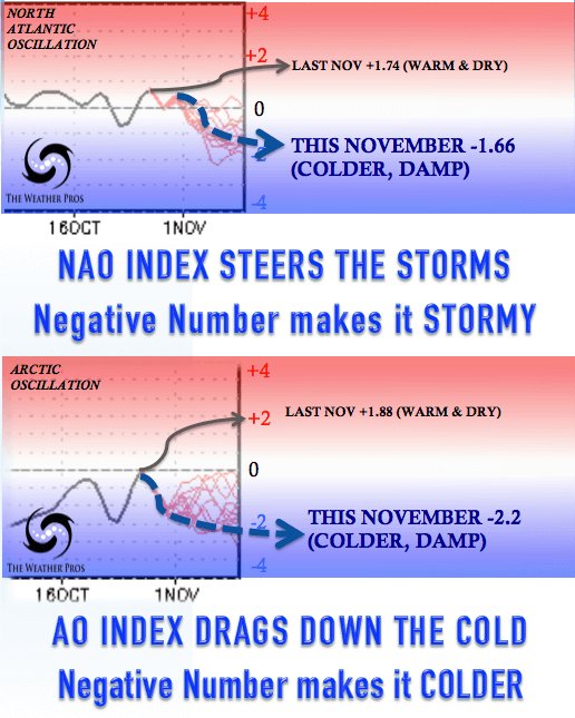
Compared it to this time last year.

_________________
_______________________________________________________________________________________________________
CLICK HERE to view NJ Strong Snowstorm Classifications
Frank_Wx- Godzilla Seeker
- Posts : 21305
Reputation : 328
Join date : 2013-01-05
Age : 31
Location : Jersey City, NJ -
Page 14 of 40 • 1 ... 8 ... 13, 14, 15 ... 27 ... 40 ![]()
|
|
|