
 Search
Long Range Thread 12.0
Page 17 of 40 •  1 ... 10 ... 16, 17, 18 ... 28 ... 40
 ![]()
Re: Long Range Thread 12.0
![]() by amugs Sat Nov 05, 2016 6:35 pm
by amugs Sat Nov 05, 2016 6:35 pm
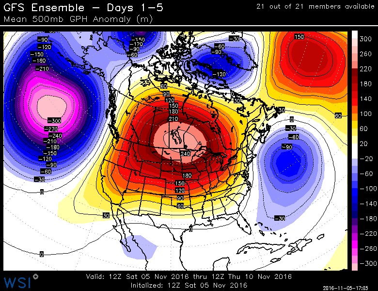
 re is the PAC JET BREAKING DOWN partially due to typhoon Media
amugs- Advanced Forecaster - Mod

- Posts : 15093
Join date : 2013-01-07
Re: Long Range Thread 12.0
![]() by StatenWx Sat Nov 05, 2016 10:17 pm
by StatenWx Sat Nov 05, 2016 10:17 pm
StatenWx- Posts : 2
Join date : 2014-03-28
Re: Long Range Thread 12.0
![]() by dkodgis Sun Nov 06, 2016 9:55 am
by dkodgis Sun Nov 06, 2016 9:55 am
http://www.propanebuzz.com/models-predicting-winter-pattern-shift-in-november/
Who knew that folks who sell propane are also avid weather enthusiasts

dkodgis- Senior Enthusiast

- Posts : 2505
Reputation : 98
Join date : 2013-12-29
Re: Long Range Thread 12.0
![]() by Snow88 Sun Nov 06, 2016 10:03 am
by Snow88 Sun Nov 06, 2016 10:03 am

Snow88- Senior Enthusiast
- Posts : 2193
Reputation : 4
Join date : 2013-01-09
Age : 35
Location : Brooklyn, NY
Re: Long Range Thread 12.0
![]() by Frank_Wx Sun Nov 06, 2016 10:08 am
by Frank_Wx Sun Nov 06, 2016 10:08 am
Here is the powerpoint I presented at the get together yesterday.
In summary, SAI (snow advanced index) is continuing to increase over Siberia and this bolds well for getting a -AO over the winter months. Additionally, the Strat PV will remain very weak through November and December which means the probability of a SSWE (sudden stratospheric warming event) increase. If one were to occur, it would be sometime between Christmas and the first 10 days of January.
We will see two shots of below normal weather over the next week to 10 days. The one next weekend may bring our first 40's of the season. Then there is a period the week before Thanksgiving that could bring us 3 to 5 days of below normal weather. I do not consider this a "pattern change" but a mere transient period of colder than normal weather.
I think the pattern change will be reserved for sometime in December. Hopefully early on.
Winter 2016-2017 Update
_________________
_______________________________________________________________________________________________________
CLICK HERE to view NJ Strong Snowstorm Classifications

Frank_Wx- Godzilla Seeker

- Posts : 21305
Reputation : 328
Join date : 2013-01-05
Age : 31
Location : Jersey City, NJ -


algae888- Advanced Forecaster

- Posts : 5311
Reputation : 46
Join date : 2013-02-05
Age : 61
Location : mt. vernon, new york
Re: Long Range Thread 12.0
![]() by amugs Sun Nov 06, 2016 4:41 pm
by amugs Sun Nov 06, 2016 4:41 pm

_________________
Mugs
AKA:King: Snow Weenie
Self Proclaimed
WINTER 2014-15 : 55.12" +.02 for 6 coatings (avg. 35")
WINTER 2015-16 Total - 29.8" (Avg 35")
WINTER 2016-17 : 39.5" so far

amugs- Advanced Forecaster - Mod
- Posts : 15093
Reputation : 213
Join date : 2013-01-07
Age : 54
Location : Hillsdale,NJ
Re: Long Range Thread 12.0
![]() by amugs Sun Nov 06, 2016 7:24 pm
by amugs Sun Nov 06, 2016 7:24 pm

_________________
Mugs
AKA:King: Snow Weenie
Self Proclaimed
WINTER 2014-15 : 55.12" +.02 for 6 coatings (avg. 35")
WINTER 2015-16 Total - 29.8" (Avg 35")
WINTER 2016-17 : 39.5" so far
amugs- Advanced Forecaster - Mod
- Posts : 15093
Reputation : 213
Join date : 2013-01-07
Age : 54
Location : Hillsdale,NJ
Re: Long Range Thread 12.0
![]() by amugs Sun Nov 06, 2016 7:38 pm
by amugs Sun Nov 06, 2016 7:38 pm

_________________
Mugs
AKA:King: Snow Weenie
Self Proclaimed
WINTER 2014-15 : 55.12" +.02 for 6 coatings (avg. 35")
WINTER 2015-16 Total - 29.8" (Avg 35")
WINTER 2016-17 : 39.5" so far
amugs- Advanced Forecaster - Mod
- Posts : 15093
Reputation : 213
Join date : 2013-01-07
Age : 54
Location : Hillsdale,NJ
Re: Long Range Thread 12.0
![]() by HectorO Sun Nov 06, 2016 10:01 pm
by HectorO Sun Nov 06, 2016 10:01 pm
Frank_Wx wrote:Good morning everyone
Here is the powerpoint I presented at the get together yesterday.
In summary, SAI (snow advanced index) is continuing to increase over Siberia and this bolds well for getting a -AO over the winter months. Additionally, the Strat PV will remain very weak through November and December which means the probability of a SSWE (sudden stratospheric warming event) increase. If one were to occur, it would be sometime between Christmas and the first 10 days of January.
We will see two shots of below normal weather over the next week to 10 days. The one next weekend may bring our first 40's of the season. Then there is a period the week before Thanksgiving that could bring us 3 to 5 days of below normal weather. I do not consider this a "pattern change" but a mere transient period of colder than normal weather.
I think the pattern change will be reserved for sometime in December. Hopefully early on.
<div><h3 style="padding: 0px; margin: 3px;"><a href="http://www.authorstream.com/Presentation/francesco481298-2958187-winter-2016-2017-update/" target="_blank" style="font:normal 18px,arial;">Winter 2016-2017 Update</a></h3><object width="425" height="354" id="player"><param name="movie" value="http://www.authorstream.com/player.swf?fb=0&nb=1&ct=5&ap=0&c=dfdfdf&pl=as&p=2958187_636140197879975876&fi=1" /><param name="allowFullScreenInteractive" value="true" /><param name="allowScriptAccess" value="always"/><embed src="http://www.authorstream.com/player.swf?fb=0&nb=1&ct=5&ap=0&c=dfdfdf&pl=as&p=2958187_636140197879975876&fi=1" type="application/x-shockwave-flash" allowscriptaccess="always" allowFullScreenInteractive="true" width="425" height="354"></embed></object><div style="font-family: arial; font-style: normal; font-variant: normal; font-weight: normal;font-size: 11px; line-height: normal; font-size-adjust: none; font-stretch: normal;">More presentations from <a href="http://www.authorstream.com/francesco481298/" target="_blank">Francesco Paparatto</a></div></div>
With so many locations for all of us, isn't it hard to say "we" might see a certain temp for the first time. I can definitely say for some people in Bergen County, have already seen highs in the high 40's for this season. Especially in Ramsey, even in Mahwah which has a sharp cut-off between humid subtropical and another climate zone.

HectorO- Pro Enthusiast

- Posts : 959
Reputation : 27
Join date : 2013-01-11
Re: Long Range Thread 12.0
![]() by amugs Mon Nov 07, 2016 9:23 pm
by amugs Mon Nov 07, 2016 9:23 pm
_________________
Mugs
AKA:King: Snow Weenie
Self Proclaimed
WINTER 2014-15 : 55.12" +.02 for 6 coatings (avg. 35")
WINTER 2015-16 Total - 29.8" (Avg 35")
WINTER 2016-17 : 39.5" so far
amugs- Advanced Forecaster - Mod
- Posts : 15093
Reputation : 213
Join date : 2013-01-07
Age : 54
Location : Hillsdale,NJ
Re: Long Range Thread 12.0
![]() by amugs Mon Nov 07, 2016 9:25 pm
by amugs Mon Nov 07, 2016 9:25 pm
_________________
Mugs
AKA:King: Snow Weenie
Self Proclaimed
WINTER 2014-15 : 55.12" +.02 for 6 coatings (avg. 35")
WINTER 2015-16 Total - 29.8" (Avg 35")
WINTER 2016-17 : 39.5" so far
amugs- Advanced Forecaster - Mod
- Posts : 15093
Reputation : 213
Join date : 2013-01-07
Age : 54
Location : Hillsdale,NJ
Re: Long Range Thread 12.0
![]() by frank 638 Tue Nov 08, 2016 4:03 pm
by frank 638 Tue Nov 08, 2016 4:03 pm
frank 638- Senior Enthusiast
- Posts : 2825
Reputation : 37
Join date : 2016-01-01
Age : 40
Location : bronx ny
Re: Long Range Thread 12.0
![]() by amugs Tue Nov 08, 2016 8:57 pm
by amugs Tue Nov 08, 2016 8:57 pm
frank 638 wrote:looks like next week might be stormy esp wed into thur with a possple nor easter
Long time to go but they had such earlier like Sat/Sun in LR and coming back to this idea. WE will monitor and we'll need something like this.
_________________
Mugs
AKA:King: Snow Weenie
Self Proclaimed
WINTER 2014-15 : 55.12" +.02 for 6 coatings (avg. 35")
WINTER 2015-16 Total - 29.8" (Avg 35")
WINTER 2016-17 : 39.5" so far
amugs- Advanced Forecaster - Mod
- Posts : 15093
Reputation : 213
Join date : 2013-01-07
Age : 54
Location : Hillsdale,NJ
Re: Long Range Thread 12.0
![]() by algae888 Thu Nov 10, 2016 4:41 am
by algae888 Thu Nov 10, 2016 4:41 am

if i'm not mistaken 2011-12 also had cold over asia. terrible winter here that year. however we do not need below normal temps to have a good winter. normal temps from mid december on could work.
algae888- Advanced Forecaster
- Posts : 5311
Reputation : 46
Join date : 2013-02-05
Age : 61
Location : mt. vernon, new york
Re: Long Range Thread 12.0
![]() by algae888 Thu Nov 10, 2016 4:47 am
by algae888 Thu Nov 10, 2016 4:47 am


algae888- Advanced Forecaster
- Posts : 5311
Reputation : 46
Join date : 2013-02-05
Age : 61
Location : mt. vernon, new york
Re: Long Range Thread 12.0
![]() by rb924119 Thu Nov 10, 2016 9:12 am
by rb924119 Thu Nov 10, 2016 9:12 am
rb924119- Meteorologist

- Posts : 6890
Reputation : 194
Join date : 2013-02-06
Age : 32
Location : Greentown, Pa
Re: Long Range Thread 12.0
![]() by amugs Thu Nov 10, 2016 2:29 pm
by amugs Thu Nov 10, 2016 2:29 pm

_________________
Mugs
AKA:King: Snow Weenie
Self Proclaimed
WINTER 2014-15 : 55.12" +.02 for 6 coatings (avg. 35")
WINTER 2015-16 Total - 29.8" (Avg 35")
WINTER 2016-17 : 39.5" so far
amugs- Advanced Forecaster - Mod
- Posts : 15093
Reputation : 213
Join date : 2013-01-07
Age : 54
Location : Hillsdale,NJ
Re: Long Range Thread 12.0
![]() by sroc4 Thu Nov 10, 2016 3:04 pm
by sroc4 Thu Nov 10, 2016 3:04 pm
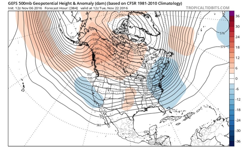
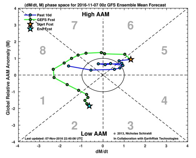
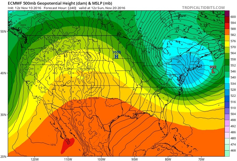
amugs wrote:Scott on the Pac Jet extension at 250 if you look runs from wpac right through into the NA cont in BC region. We have a nino hangover and it is waning after a super nino. I showed this in posts and a research link in Sept. I have to dig this up if need be. MJO progged to go into 7-8-1 yes and we have a pattern change evolving I have written about this as well My point being g that we need this Pac Jet firehouse extension to slow down so we can get cold to rebuild in CAN and snow pack up there a well for an extension of a cold air pool besides Siberia imo. Mechanism not in place presently to slow this down , does MJO help, I believe so but need heights to rise by the GOA LP to retrograde or dissolve. From what I have read as well the AAM is still in a mod positive state which aids to the PAC jet extension and is orogged to go nutral/negative in about a 10 days. Also mountain torque from Asia is ina pos state aiding to this full extension.from what I have read. Could I be wrong surely, ain't being a nah nah hee just stating some weather info.
Maybe in Sept Mugsy there was a Nino hangover, but forcing are not el nino. I was going to do a nice write up, but intead CPC and NOAA did it for me. You posted the images in the LR thread but here is the latest ENSO status update valid today
http://www.cpc.ncep.noaa.gov/products/analysis_monitoring/enso_advisory/ensodisc.pdf
"Convection was suppressed over the central tropical Pacific and enhanced over Indonesia
(Fig. 5). The lower-level easterly winds were weakly enhanced near and west of the International Date
Line, and anomalously westerly upper-level winds were mainly west of the International Date Line.
Overall, the ocean and atmosphere system reflected weak La Niña conditions.
This quote from the other board you posted:
"How do the models handle this residual Nino forcing which is still evident as this La Nina is beginning to take shape?
The Pacific pattern this October with the Nino-like record Alaskan ridge getting undercut by the Nina Pacific Jet and displaced Aleutian Low to the PAC NW
producing the wettest month on record for Spokane, WA."
Again very Nina like with trop forcing/ dominant walker cell formation coming out of the E IO/Indonesia regions enhances the polar westerlies(aka 250 and 500mb N Pac jet). Yes This floods the country with Pac air. True Nino conditions, and correct me if Im wrong" tend to favor a dominat STJ which has been all but shut off, which pumps the SE ridging and persistent trough in the west bringing the rains associated with Nino conditions into the southern tier of the CONUS and NOT the Spokane, WA area. Remember last years super NINO DID NOT behave like the typical NIno years as seen by the very same weird tropical forcings being dominated by MJO phases 4-6 for long periods in lieu of the boiling IO. I mean I guess the point is mute as there is still above normal conditions no matter how you slice it. The warm PDO and the warm Atlantic likely means that the hangover is simply associated with these warm region such that when the upper level and low level winds switch back out the SW and W the above normal SST bring above normal air masses. Our current Canadian air masses are not cold enough and dominant enough, hopefully yet, to knock back the warmth for good. Hopefully its a mere time of year issue and as we get deeper into the winter the cold air intusions have more staying power. The SSWE def did not favor NA to recieve the core of the cold. Until the vortex switches positions the cold will likely stay locked on the wrong side of the N Hemisphere. Good news is as per guys like J Cohen the strat vortex should remain weak despite it coming back together as one entity instead of the split that it has undergone over the past 2 weeks, and the probability of addition wave 1 or 2 fluxes are high for late dec and early Jan to hopefully trigger another SSWE. But again where the vortex centers plays a big role in how the trop vortex behaves. We shall see.
_________________
"In weather and in life, there's no winning and losing; there's only winning and learning."
WINTER 2012/2013 TOTALS 43.65"WINTER 2017/2018 TOTALS 62.85" WINTER 2022/2023 TOTALS 4.9"
WINTER 2013/2014 TOTALS 64.85"WINTER 2018/2019 TOTALS 14.25" WINTER 2023/2024 TOTALS 13.1"
WINTER 2014/2015 TOTALS 71.20"WINTER 2019/2020 TOTALS 6.35"
WINTER 2015/2016 TOTALS 35.00"WINTER 2020/2021 TOTALS 37.75"
WINTER 2016/2017 TOTALS 42.25"WINTER 2021/2022 TOTALS 31.65"

sroc4- Admin
- Posts : 8331
Reputation : 301
Join date : 2013-01-07
Location : Wading River, LI
Re: Long Range Thread 12.0
![]() by amugs Thu Nov 10, 2016 3:37 pm
by amugs Thu Nov 10, 2016 3:37 pm
_________________
Mugs
AKA:King: Snow Weenie
Self Proclaimed
WINTER 2014-15 : 55.12" +.02 for 6 coatings (avg. 35")
WINTER 2015-16 Total - 29.8" (Avg 35")
WINTER 2016-17 : 39.5" so far
amugs- Advanced Forecaster - Mod
- Posts : 15093
Reputation : 213
Join date : 2013-01-07
Age : 54
Location : Hillsdale,NJ
Re: Long Range Thread 12.0
![]() by amugs Fri Nov 11, 2016 9:58 am
by amugs Fri Nov 11, 2016 9:58 am
_________________
Mugs
AKA:King: Snow Weenie
Self Proclaimed
WINTER 2014-15 : 55.12" +.02 for 6 coatings (avg. 35")
WINTER 2015-16 Total - 29.8" (Avg 35")
WINTER 2016-17 : 39.5" so far
amugs- Advanced Forecaster - Mod
- Posts : 15093
Reputation : 213
Join date : 2013-01-07
Age : 54
Location : Hillsdale,NJ
Re: Long Range Thread 12.0
![]() by amugs Fri Nov 11, 2016 10:56 am
by amugs Fri Nov 11, 2016 10:56 am
_________________
Mugs
AKA:King: Snow Weenie
Self Proclaimed
WINTER 2014-15 : 55.12" +.02 for 6 coatings (avg. 35")
WINTER 2015-16 Total - 29.8" (Avg 35")
WINTER 2016-17 : 39.5" so far
amugs- Advanced Forecaster - Mod
- Posts : 15093
Reputation : 213
Join date : 2013-01-07
Age : 54
Location : Hillsdale,NJ
Re: Long Range Thread 12.0
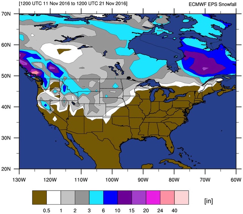
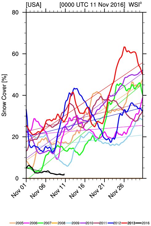
![]() by amugs Fri Nov 11, 2016 10:59 am
by amugs Fri Nov 11, 2016 10:59 am
.png)
.png)
_________________
Mugs
AKA:King: Snow Weenie
Self Proclaimed
WINTER 2014-15 : 55.12" +.02 for 6 coatings (avg. 35")
WINTER 2015-16 Total - 29.8" (Avg 35")
WINTER 2016-17 : 39.5" so far
amugs- Advanced Forecaster - Mod
- Posts : 15093
Reputation : 213
Join date : 2013-01-07
Age : 54
Location : Hillsdale,NJ
Re: Long Range Thread 12.0
![]() by amugs Fri Nov 11, 2016 11:19 am
by amugs Fri Nov 11, 2016 11:19 am

_________________
Mugs
AKA:King: Snow Weenie
Self Proclaimed
WINTER 2014-15 : 55.12" +.02 for 6 coatings (avg. 35")
WINTER 2015-16 Total - 29.8" (Avg 35")
WINTER 2016-17 : 39.5" so far
amugs- Advanced Forecaster - Mod
- Posts : 15093
Reputation : 213
Join date : 2013-01-07
Age : 54
Location : Hillsdale,NJ
Re: Long Range Thread 12.0
![]() by weatherwatchermom Fri Nov 11, 2016 3:11 pm
by weatherwatchermom Fri Nov 11, 2016 3:11 pm

weatherwatchermom- Senior Enthusiast
- Posts : 3750
Reputation : 77
Join date : 2014-11-25
Age : 60
Location : Hazlet Township, NJ
Re: Long Range Thread 12.0
![]() by frank 638 Fri Nov 11, 2016 7:07 pm
by frank 638 Fri Nov 11, 2016 7:07 pm
frank 638- Senior Enthusiast
- Posts : 2825
Reputation : 37
Join date : 2016-01-01
Age : 40
Location : bronx ny
Re: Long Range Thread 12.0
![]() by Dunnzoo Fri Nov 11, 2016 10:12 pm
by Dunnzoo Fri Nov 11, 2016 10:12 pm
weatherwatchermom wrote:are we really looking at possibility of snow over thanksgiving?
It looks like some precip a few days before Turkey Day, but it does look like it will be cold...
_________________
Janet
Snowfall winter of 2023-2024 17.5"
Snowfall winter of 2022-2023 6.0"
Snowfall winter of 2021-2022 17.6" 1" sleet 2/25/22
Snowfall winter of 2020-2021 51.1"
Snowfall winter of 2019-2020 8.5"
Snowfall winter of 2018-2019 25.1"
Snowfall winter of 2017-2018 51.9"
Snowfall winter of 2016-2017 45.6"
Snowfall winter of 2015-2016 29.5"
Snowfall winter of 2014-2015 50.55"
Snowfall winter of 2013-2014 66.5"

Dunnzoo- Senior Enthusiast - Mod
- Posts : 4892
Reputation : 68
Join date : 2013-01-11
Age : 62
Location : Westwood, NJ
Page 17 of 40 • 1 ... 10 ... 16, 17, 18 ... 28 ... 40 ![]()
|
|
|