
 Search
Long Range Thread 12.0
Page 18 of 40 •  1 ... 10 ... 17, 18, 19 ... 29 ... 40
 ![]()
Re: Long Range Thread 12.0
![]() by frank 638 Fri Nov 11, 2016 7:07 pm
by frank 638 Fri Nov 11, 2016 7:07 pm
frank 638- Senior Enthusiast

- Posts : 2825
Join date : 2016-01-01
Re: Long Range Thread 12.0
![]() by Dunnzoo Fri Nov 11, 2016 10:12 pm
by Dunnzoo Fri Nov 11, 2016 10:12 pm
weatherwatchermom wrote:are we really looking at possibility of snow over thanksgiving?
It looks like some precip a few days before Turkey Day, but it does look like it will be cold...
Dunnzoo- Senior Enthusiast - Mod

- Posts : 4892
Join date : 2013-01-11
Re: Long Range Thread 12.0
![]() by sroc4 Sat Nov 12, 2016 7:11 am
by sroc4 Sat Nov 12, 2016 7:11 am
Dunnzoo wrote:weatherwatchermom wrote:are we really looking at possibility of snow over thanksgiving?
It looks like some precip a few days before Turkey Day, but it does look like it will be cold...
I certainly wouldn't write off anything in the long term but I agree with Janet. There will likely no be enough cold air around to support snow.
_________________
"In weather and in life, there's no winning and losing; there's only winning and learning."
WINTER 2012/2013 TOTALS 43.65"WINTER 2017/2018 TOTALS 62.85" WINTER 2022/2023 TOTALS 4.9"
WINTER 2013/2014 TOTALS 64.85"WINTER 2018/2019 TOTALS 14.25" WINTER 2023/2024 TOTALS 13.1"
WINTER 2014/2015 TOTALS 71.20"WINTER 2019/2020 TOTALS 6.35"
WINTER 2015/2016 TOTALS 35.00"WINTER 2020/2021 TOTALS 37.75"
WINTER 2016/2017 TOTALS 42.25"WINTER 2021/2022 TOTALS 31.65"

sroc4- Admin

- Posts : 8331
Reputation : 301
Join date : 2013-01-07
Location : Wading River, LI
Re: Long Range Thread 12.0
![]() by sroc4 Sat Nov 12, 2016 8:30 am
by sroc4 Sat Nov 12, 2016 8:30 am
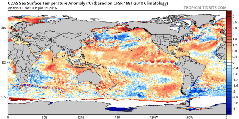
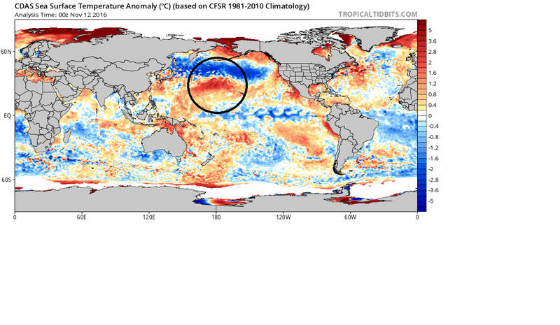
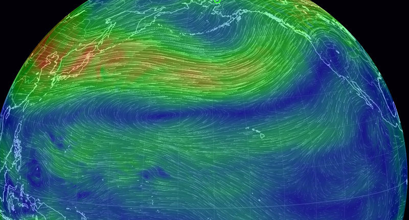
These are the Global Sea Surface Temp Anomalies (SSTA) from This morning followed by Sept 7th; then June 15th 2016 . Pay particular attention to three things. 1) What prob stands out the most is the N Pac. In only two short months our nice warm "blob" of strong SSTA in the GOA have been eroded significantly because extremely cold SSTA have developed and expanded eastward undercutting the blob. 2) notice how the cold SSTA have spread westward in the ENSO region in the Trop Pac and 3) notice where the SST across the globe are going. For instance look at the S Atlantic between S America and Africa, look at the N Atlantic and off the EC of the US, the Trop Pac, the IO, the N Pac from June till now. As a whole the entire global SST are cooling the effects of which could be profound in the coming years on global air temps as whole if this trend were to hold.

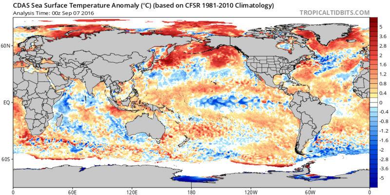
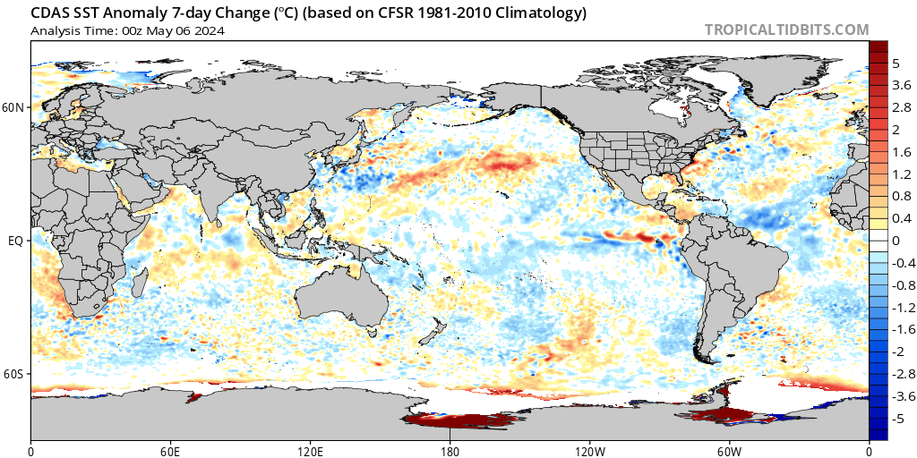
Here are the SSTA changes over the last 7 days which shows the SST cooling globally:
Now if you recall the reason we like the warm blob in the NE Pac/GOA is because the temp gradients between SSTA tend to favor ridging that extends up into Alaska and the West coast of Canada and the CONUS (-EPO and +PNA respectively) when you have that warm blob in the GOA. However; as you can see the strongest temp gradient is set up in a distinct horizontal fashion from west to east, but is no longer strongest near the GOA. Now notice there is the warmest SSTA of the N Hemispheric Pac ocean smack dab in the center of the Pac due south of the prev described cold anomalies. It is right here in this location that we have the greatest differences in the SSTA. NOTE: If this SSTA configuration conts into the winter it might spell disaster without other large scale pattern changes to help us out. Things like a strong MJO pulse in favorable phases or a strat warming event to name a couple.
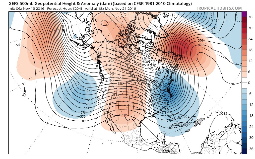
Likely NOT coincidentally an HP ridge is centered in the Central Pac and due north is the exceptionally strong N Pac jet. Here is 500mb followed by 250mb. But also notice how the lower atmosphere(tropospheric circulation) seems to be lined up with the stratospheric circulation (70mb and 10mb).
Following maps are 500mb, 250mb, 70mb, and 10mb respectively:


Now we began this discussion at the surface regarding the SSTA and have worked our way up. But if we now re-start at the top, in the Stratosphere, there other extremely interesting observations. I unfort don't have time this morning to go into those details, but as we know we had an unprecedented SSWE and split that has occurred. You've prob heard multiple times about how the coldest air in the N Hemisphere has been locked up and centered over in Asia and eastern Europe.
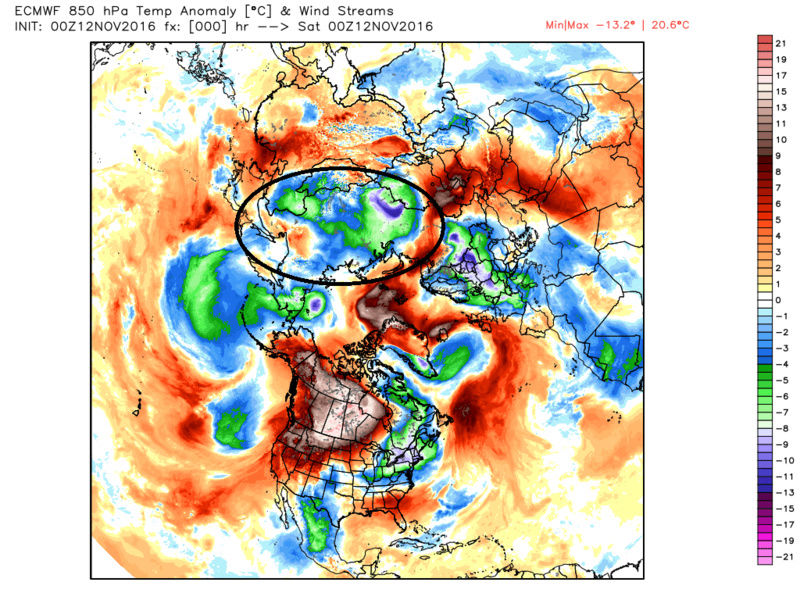
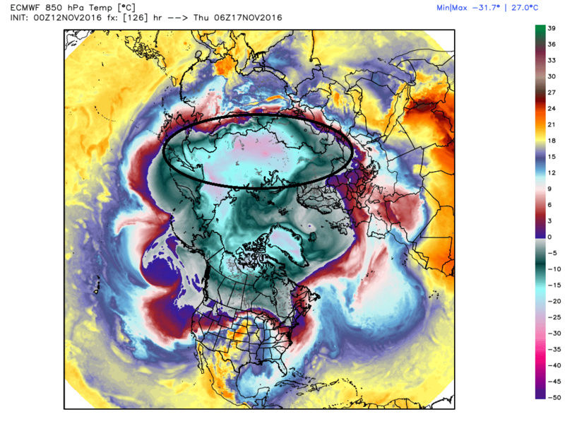
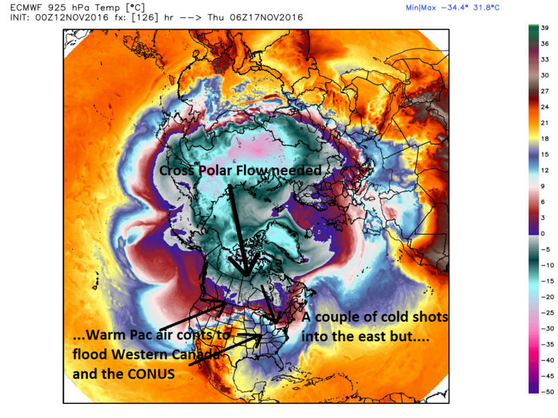
When you look at the positioning of the stratospheric circulation from the view point of overtop the arctic circle you can understand why. Unfort we will likely need the strat circulation to be positioned differently than it is currently in order to unlock the cold air in siberia and the arctic. By unlock I mean reconfigure the tropospheric upper level pattern(500mb and 250mb) such that we get a cross polar flow which will filter that cold air down into Canada and eventually the CONUS. Right now we have moderately cold air masses at best to our N which get mixed with warmer pacific air due to the prev described strong N Pac jet flooding the country with Pac air.
This is where I must stop but will try to cont tomorrow am with those images and discussion.
_________________
"In weather and in life, there's no winning and losing; there's only winning and learning."
WINTER 2012/2013 TOTALS 43.65"WINTER 2017/2018 TOTALS 62.85" WINTER 2022/2023 TOTALS 4.9"
WINTER 2013/2014 TOTALS 64.85"WINTER 2018/2019 TOTALS 14.25" WINTER 2023/2024 TOTALS 13.1"
WINTER 2014/2015 TOTALS 71.20"WINTER 2019/2020 TOTALS 6.35"
WINTER 2015/2016 TOTALS 35.00"WINTER 2020/2021 TOTALS 37.75"
WINTER 2016/2017 TOTALS 42.25"WINTER 2021/2022 TOTALS 31.65"
sroc4- Admin
- Posts : 8331
Reputation : 301
Join date : 2013-01-07
Location : Wading River, LI
Re: Long Range Thread 12.0
![]() by Frank_Wx Sat Nov 12, 2016 9:48 am
by Frank_Wx Sat Nov 12, 2016 9:48 am
Fact of the matter continues to be the Stratosphere PV is very weak.
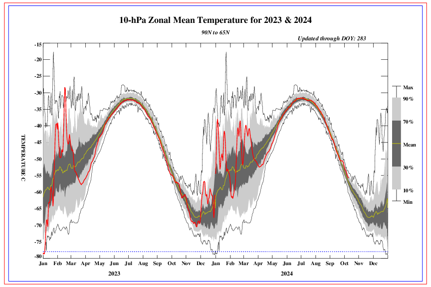
The lime green line is a mean of 10hPa temps between 1979 and 2015. Check out November 2016. The red line, which is current temperatures, is above the green line. So instead of the Stratosphere cooling, as is typically the case, it is warming at both the lower and mid levels. This makes it susceptible to a SSWE in the near future.
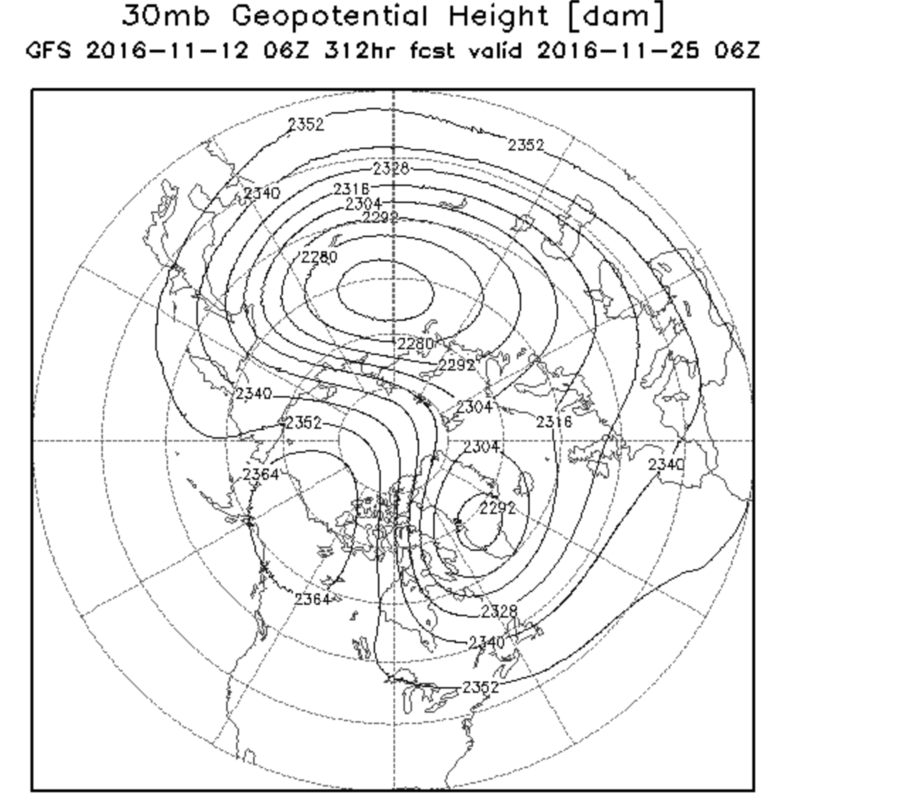

GFS long range shows a near PV split around Thanksgiving. The main vortex is over Siberia and another lobe is left over Greenland.
Here is what a record-breaking SAI (snow advanced index) in Siberia can do. The High's that develop are anomalously strong and promote poleward heat flux into the Stratosphere. That High in eastern Europe could be a possible precursor to a SSWE sometime late this month. GFS is close. We'll see.

_________________
_______________________________________________________________________________________________________
CLICK HERE to view NJ Strong Snowstorm Classifications

Frank_Wx- Godzilla Seeker
- Posts : 21305
Reputation : 328
Join date : 2013-01-05
Age : 31
Location : Jersey City, NJ -

Re: Long Range Thread 12.0
![]() by sroc4 Sat Nov 12, 2016 10:32 am
by sroc4 Sat Nov 12, 2016 10:32 am
_________________
"In weather and in life, there's no winning and losing; there's only winning and learning."
WINTER 2012/2013 TOTALS 43.65"WINTER 2017/2018 TOTALS 62.85" WINTER 2022/2023 TOTALS 4.9"
WINTER 2013/2014 TOTALS 64.85"WINTER 2018/2019 TOTALS 14.25" WINTER 2023/2024 TOTALS 13.1"
WINTER 2014/2015 TOTALS 71.20"WINTER 2019/2020 TOTALS 6.35"
WINTER 2015/2016 TOTALS 35.00"WINTER 2020/2021 TOTALS 37.75"
WINTER 2016/2017 TOTALS 42.25"WINTER 2021/2022 TOTALS 31.65"
sroc4- Admin
- Posts : 8331
Reputation : 301
Join date : 2013-01-07
Location : Wading River, LI
Re: Long Range Thread 12.0
![]() by algae888 Sat Nov 12, 2016 12:03 pm
by algae888 Sat Nov 12, 2016 12:03 pm

algae888- Advanced Forecaster

- Posts : 5311
Reputation : 46
Join date : 2013-02-05
Age : 61
Location : mt. vernon, new york
Re: Long Range Thread 12.0
![]() by amugs Sat Nov 12, 2016 1:57 pm
by amugs Sat Nov 12, 2016 1:57 pm
_________________
Mugs
AKA:King: Snow Weenie
Self Proclaimed
WINTER 2014-15 : 55.12" +.02 for 6 coatings (avg. 35")
WINTER 2015-16 Total - 29.8" (Avg 35")
WINTER 2016-17 : 39.5" so far

amugs- Advanced Forecaster - Mod
- Posts : 15093
Reputation : 213
Join date : 2013-01-07
Age : 54
Location : Hillsdale,NJ
Re: Long Range Thread 12.0
![]() by algae888 Sat Nov 12, 2016 3:37 pm
by algae888 Sat Nov 12, 2016 3:37 pm
Mugs north Dakota temp dep is +16* so far for November and if the GFS is corrected that's 1 to 2 feet of snowamugs wrote:How about this for the Northern plains - this is what we Need to see moving forward.
algae888- Advanced Forecaster
- Posts : 5311
Reputation : 46
Join date : 2013-02-05
Age : 61
Location : mt. vernon, new york
Re: Long Range Thread 12.0
![]() by amugs Sun Nov 13, 2016 9:11 am
by amugs Sun Nov 13, 2016 9:11 am
_________________
Mugs
AKA:King: Snow Weenie
Self Proclaimed
WINTER 2014-15 : 55.12" +.02 for 6 coatings (avg. 35")
WINTER 2015-16 Total - 29.8" (Avg 35")
WINTER 2016-17 : 39.5" so far
amugs- Advanced Forecaster - Mod
- Posts : 15093
Reputation : 213
Join date : 2013-01-07
Age : 54
Location : Hillsdale,NJ
Re: Long Range Thread 12.0
![]() by weatherwatchermom Sun Nov 13, 2016 9:51 am
by weatherwatchermom Sun Nov 13, 2016 9:51 am
amugs wrote:GEFS for turkey week - trough over NE - blustery and snow flakes flying?
love it!

weatherwatchermom- Senior Enthusiast
- Posts : 3750
Reputation : 77
Join date : 2014-11-25
Age : 60
Location : Hazlet Township, NJ
Re: Long Range Thread 12.0
![]() by amugs Sun Nov 13, 2016 10:13 am
by amugs Sun Nov 13, 2016 10:13 am

_________________
Mugs
AKA:King: Snow Weenie
Self Proclaimed
WINTER 2014-15 : 55.12" +.02 for 6 coatings (avg. 35")
WINTER 2015-16 Total - 29.8" (Avg 35")
WINTER 2016-17 : 39.5" so far
amugs- Advanced Forecaster - Mod
- Posts : 15093
Reputation : 213
Join date : 2013-01-07
Age : 54
Location : Hillsdale,NJ
Re: Long Range Thread 12.0
![]() by algae888 Sun Nov 13, 2016 12:27 pm
by algae888 Sun Nov 13, 2016 12:27 pm


algae888- Advanced Forecaster
- Posts : 5311
Reputation : 46
Join date : 2013-02-05
Age : 61
Location : mt. vernon, new york
Re: Long Range Thread 12.0
![]() by algae888 Sun Nov 13, 2016 12:47 pm
by algae888 Sun Nov 13, 2016 12:47 pm


-epo

-nao +pna -ao we need to watch this time frame.

+pna -nao continues
algae888- Advanced Forecaster
- Posts : 5311
Reputation : 46
Join date : 2013-02-05
Age : 61
Location : mt. vernon, new york
Re: Long Range Thread 12.0
![]() by algae888 Sun Nov 13, 2016 12:54 pm
by algae888 Sun Nov 13, 2016 12:54 pm


look at the westward progression of the cold air over Eurasia
algae888- Advanced Forecaster
- Posts : 5311
Reputation : 46
Join date : 2013-02-05
Age : 61
Location : mt. vernon, new york
Re: Long Range Thread 12.0
![]() by amugs Sun Nov 13, 2016 4:55 pm
by amugs Sun Nov 13, 2016 4:55 pm
IF we get a cross polar flow with these temps yes they shall moderate but holy cannoli batman this air is ridiculously cold!
_________________
Mugs
AKA:King: Snow Weenie
Self Proclaimed
WINTER 2014-15 : 55.12" +.02 for 6 coatings (avg. 35")
WINTER 2015-16 Total - 29.8" (Avg 35")
WINTER 2016-17 : 39.5" so far
amugs- Advanced Forecaster - Mod
- Posts : 15093
Reputation : 213
Join date : 2013-01-07
Age : 54
Location : Hillsdale,NJ
Re: Long Range Thread 12.0
![]() by amugs Sun Nov 13, 2016 8:27 pm
by amugs Sun Nov 13, 2016 8:27 pm

_________________
Mugs
AKA:King: Snow Weenie
Self Proclaimed
WINTER 2014-15 : 55.12" +.02 for 6 coatings (avg. 35")
WINTER 2015-16 Total - 29.8" (Avg 35")
WINTER 2016-17 : 39.5" so far
amugs- Advanced Forecaster - Mod
- Posts : 15093
Reputation : 213
Join date : 2013-01-07
Age : 54
Location : Hillsdale,NJ
Re: Long Range Thread 12.0
![]() by amugs Sun Nov 13, 2016 8:28 pm
by amugs Sun Nov 13, 2016 8:28 pm


_________________
Mugs
AKA:King: Snow Weenie
Self Proclaimed
WINTER 2014-15 : 55.12" +.02 for 6 coatings (avg. 35")
WINTER 2015-16 Total - 29.8" (Avg 35")
WINTER 2016-17 : 39.5" so far
amugs- Advanced Forecaster - Mod
- Posts : 15093
Reputation : 213
Join date : 2013-01-07
Age : 54
Location : Hillsdale,NJ
Re: Long Range Thread 12.0
![]() by amugs Sun Nov 13, 2016 8:29 pm
by amugs Sun Nov 13, 2016 8:29 pm


_________________
Mugs
AKA:King: Snow Weenie
Self Proclaimed
WINTER 2014-15 : 55.12" +.02 for 6 coatings (avg. 35")
WINTER 2015-16 Total - 29.8" (Avg 35")
WINTER 2016-17 : 39.5" so far
amugs- Advanced Forecaster - Mod
- Posts : 15093
Reputation : 213
Join date : 2013-01-07
Age : 54
Location : Hillsdale,NJ
Re: Long Range Thread 12.0
![]() by amugs Sun Nov 13, 2016 8:32 pm
by amugs Sun Nov 13, 2016 8:32 pm
_________________
Mugs
AKA:King: Snow Weenie
Self Proclaimed
WINTER 2014-15 : 55.12" +.02 for 6 coatings (avg. 35")
WINTER 2015-16 Total - 29.8" (Avg 35")
WINTER 2016-17 : 39.5" so far
amugs- Advanced Forecaster - Mod
- Posts : 15093
Reputation : 213
Join date : 2013-01-07
Age : 54
Location : Hillsdale,NJ
Re: Long Range Thread 12.0
![]() by amugs Sun Nov 13, 2016 8:34 pm
by amugs Sun Nov 13, 2016 8:34 pm

_________________
Mugs
AKA:King: Snow Weenie
Self Proclaimed
WINTER 2014-15 : 55.12" +.02 for 6 coatings (avg. 35")
WINTER 2015-16 Total - 29.8" (Avg 35")
WINTER 2016-17 : 39.5" so far
amugs- Advanced Forecaster - Mod
- Posts : 15093
Reputation : 213
Join date : 2013-01-07
Age : 54
Location : Hillsdale,NJ
Re: Long Range Thread 12.0
![]() by amugs Sun Nov 13, 2016 8:58 pm
by amugs Sun Nov 13, 2016 8:58 pm

_________________
Mugs
AKA:King: Snow Weenie
Self Proclaimed
WINTER 2014-15 : 55.12" +.02 for 6 coatings (avg. 35")
WINTER 2015-16 Total - 29.8" (Avg 35")
WINTER 2016-17 : 39.5" so far
amugs- Advanced Forecaster - Mod
- Posts : 15093
Reputation : 213
Join date : 2013-01-07
Age : 54
Location : Hillsdale,NJ
Re: Long Range Thread 12.0
![]() by HectorO Sun Nov 13, 2016 9:06 pm
by HectorO Sun Nov 13, 2016 9:06 pm

HectorO- Pro Enthusiast

- Posts : 959
Reputation : 27
Join date : 2013-01-11
Re: Long Range Thread 12.0
![]() by Frank_Wx Sun Nov 13, 2016 10:44 pm
by Frank_Wx Sun Nov 13, 2016 10:44 pm
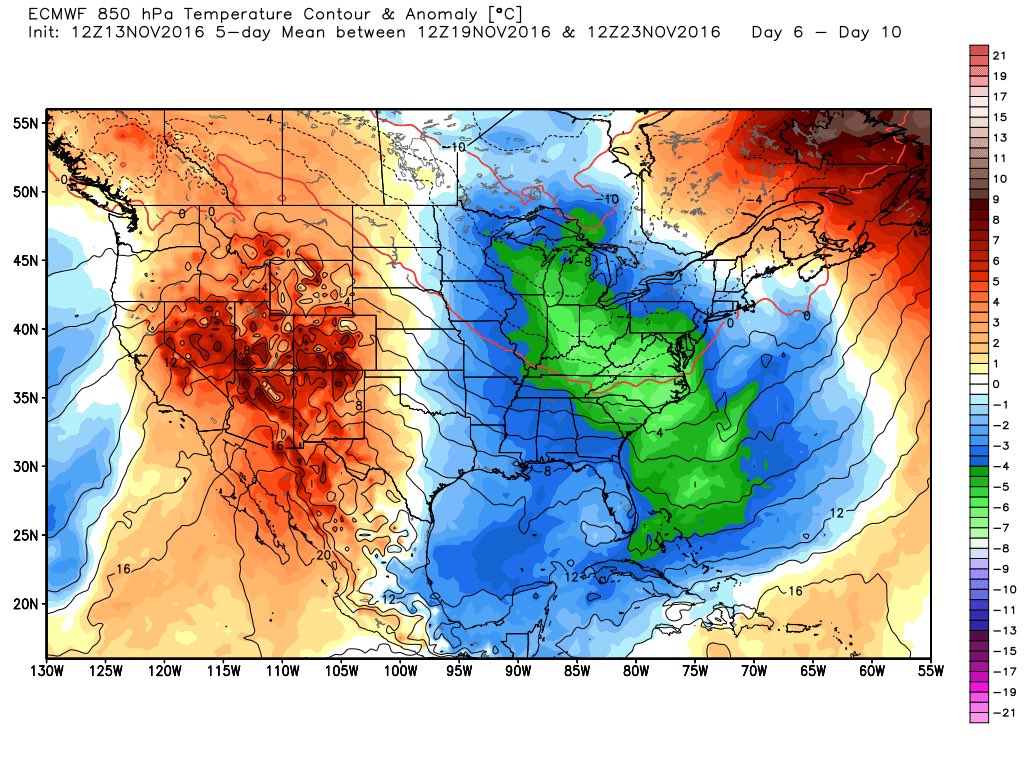
At the get together I felt Thanksgiving time frame could bring us a 3-5 day stretch of below normal weather. That still looks possible if the long range GFS comes to fruition. But again, it's moderated cold and not a true "blast." It will be tough to get a snow event out of something like that in a pattern like this. But this time of year with the low sun angle it may not take much so we'll have to see.

_________________
_______________________________________________________________________________________________________
CLICK HERE to view NJ Strong Snowstorm Classifications
Frank_Wx- Godzilla Seeker
- Posts : 21305
Reputation : 328
Join date : 2013-01-05
Age : 31
Location : Jersey City, NJ -
Re: Long Range Thread 12.0
![]() by Frank_Wx Sun Nov 13, 2016 10:54 pm
by Frank_Wx Sun Nov 13, 2016 10:54 pm

_________________
_______________________________________________________________________________________________________
CLICK HERE to view NJ Strong Snowstorm Classifications
Frank_Wx- Godzilla Seeker
- Posts : 21305
Reputation : 328
Join date : 2013-01-05
Age : 31
Location : Jersey City, NJ -
Re: Long Range Thread 12.0
![]() by Frank_Wx Sun Nov 13, 2016 10:58 pm
by Frank_Wx Sun Nov 13, 2016 10:58 pm

_________________
_______________________________________________________________________________________________________
CLICK HERE to view NJ Strong Snowstorm Classifications
Frank_Wx- Godzilla Seeker
- Posts : 21305
Reputation : 328
Join date : 2013-01-05
Age : 31
Location : Jersey City, NJ -
Re: Long Range Thread 12.0
![]() by Frank_Wx Sun Nov 13, 2016 11:00 pm
by Frank_Wx Sun Nov 13, 2016 11:00 pm
_________________
_______________________________________________________________________________________________________
CLICK HERE to view NJ Strong Snowstorm Classifications
Frank_Wx- Godzilla Seeker
- Posts : 21305
Reputation : 328
Join date : 2013-01-05
Age : 31
Location : Jersey City, NJ -
Page 18 of 40 • 1 ... 10 ... 17, 18, 19 ... 29 ... 40 ![]()
|
|
|