
 Search
Long Range Thread 12.0
Page 29 of 40 •  1 ... 16 ... 28, 29, 30 ... 34 ... 40
 ![]()
Re: Long Range Thread 12.0
![]() by skinsfan1177 Thu Dec 01, 2016 10:20 am
by skinsfan1177 Thu Dec 01, 2016 10:20 am
skinsfan1177- Senior Enthusiast

- Posts : 4485
Join date : 2013-01-07
Re: Long Range Thread 12.0
![]() by algae888 Thu Dec 01, 2016 12:24 pm
by algae888 Thu Dec 01, 2016 12:24 pm
algae888- Advanced Forecaster

- Posts : 5311
Join date : 2013-02-05
Re: Long Range Thread 12.0
![]() by CPcantmeasuresnow Thu Dec 01, 2016 12:39 pm
by CPcantmeasuresnow Thu Dec 01, 2016 12:39 pm
amugs wrote:GFS forecasting a decent heat wave flux as per Dr.Cohen
I'm not throwing this out as a criticism just as a suggestion for we of the weak minds here.
Sometimes when the more knowledgeable on the board make comments like this you might want to add afterward something like, "and this is a positive sign for cold and snow", or "this sucks for cold and snow".
I honestly have no idea half the time.

CPcantmeasuresnow- Wx Statistician Guru

- Posts : 7274
Reputation : 230
Join date : 2013-01-07
Age : 103
Location : Eastern Orange County, NY
Re: Long Range Thread 12.0
![]() by algae888 Thu Dec 01, 2016 1:05 pm
by algae888 Thu Dec 01, 2016 1:05 pm

algae888- Advanced Forecaster
- Posts : 5311
Reputation : 46
Join date : 2013-02-05
Age : 61
Location : mt. vernon, new york
Re: Long Range Thread 12.0
![]() by amugs Thu Dec 01, 2016 4:43 pm
by amugs Thu Dec 01, 2016 4:43 pm
Only kidding my man!
Now look at this ny the euro ens run as of 12z. Delayed run by about 2 hours but wowza imho a huge northern pac block , negative wpo and epo which will allow a cross polar flow into the conus and bleed east. Canada goes into the freezer big time as does the western US and it slides east.
Major snowpack coming for Can, western usa northern tier and midwest. all good news.

_________________
Mugs
AKA:King: Snow Weenie
Self Proclaimed
WINTER 2014-15 : 55.12" +.02 for 6 coatings (avg. 35")
WINTER 2015-16 Total - 29.8" (Avg 35")
WINTER 2016-17 : 39.5" so far

amugs- Advanced Forecaster - Mod

- Posts : 15093
Reputation : 213
Join date : 2013-01-07
Age : 54
Location : Hillsdale,NJ
Re: Long Range Thread 12.0
![]() by amugs Thu Dec 01, 2016 5:22 pm
by amugs Thu Dec 01, 2016 5:22 pm

This is a very nice look - NPAC block could be our first real accumulating snow threat for the entire region - not a secs 4"plus but maybe a 2" plus for NYC Metro and BETTER N & W - when the hell was the last time this was said??
Negative WPO big time over western Aleutians and Negative EPO and Nuetral PNA that forms a horse shoe over the top into the AO and East based block - east of greenland - buckles the jet a bit more on the Atlantic side.
_________________
Mugs
AKA:King: Snow Weenie
Self Proclaimed
WINTER 2014-15 : 55.12" +.02 for 6 coatings (avg. 35")
WINTER 2015-16 Total - 29.8" (Avg 35")
WINTER 2016-17 : 39.5" so far
amugs- Advanced Forecaster - Mod
- Posts : 15093
Reputation : 213
Join date : 2013-01-07
Age : 54
Location : Hillsdale,NJ
Re: Long Range Thread 12.0
![]() by amugs Thu Dec 01, 2016 5:30 pm
by amugs Thu Dec 01, 2016 5:30 pm
THE PATTERN FOR NEXT WEEK IS NOT CONDUCIVE TO A SOLELY BLENDED APPROACH, AS THIS WOULD LEAD TO PRECIPITATION CHANCES EVERY DAY AND SMOOTH OUT THE TEMPERATURES EXTREMES. TO COMPLICATE MATTERS, THE 12Z ECMWF WAS NOT AVAILABLE FOR THE FORECAST. THE 12Z GFS WAS THEREFORE CLOSELY FOLLOWED, BUT NOT BLINDLY, AS THE GENERAL PATTERN WAS SUPPORTED BY THE 00Z ECMWF AND 06Z GFS. THE FIRST SYSTEM IS LOW PRESSURE TRACKING NORTHEASTWARD FROM THE SOUTHEASTERN UNITED STATES. THE TIMING ON THIS IS TUESDAY AND TUESDAY NIGHT. THERE REMAIN QUESTIONS AS TO WHETHER THE LOW ACTUALLY REACHES THE AREA OR STAYS TO THE SOUTH, OR IF THE LOW TRACKS TO THE EAST AND WARM SLOTS THE AREA. THE PROBABILITY OF PRECIPITATION WAS THEREFORE LIMITED TO 40 PERCENT. AN ARCTIC FRONT AND POSSIBLE ASSOCIATED LOW THEN COME THROUGH BY THE END OF THE WEEK. AGAIN, THE 12Z GFS WAS USED WHICH HAS A TIMING OF WEDNESDAY NIGHT INTO THURSDAY. BOTH SYSTEMS WILL BRING SOME CHANCE FOR WINTRY PRECIPITATION, WITH THE ARCTIC FRONT PERHAPS PRESENTING A FLASH FREEZE THREAT.
_________________
Mugs
AKA:King: Snow Weenie
Self Proclaimed
WINTER 2014-15 : 55.12" +.02 for 6 coatings (avg. 35")
WINTER 2015-16 Total - 29.8" (Avg 35")
WINTER 2016-17 : 39.5" so far
amugs- Advanced Forecaster - Mod
- Posts : 15093
Reputation : 213
Join date : 2013-01-07
Age : 54
Location : Hillsdale,NJ
Re: Long Range Thread 12.0
![]() by Frank_Wx Thu Dec 01, 2016 5:32 pm
by Frank_Wx Thu Dec 01, 2016 5:32 pm
_________________
_______________________________________________________________________________________________________
CLICK HERE to view NJ Strong Snowstorm Classifications

Frank_Wx- Godzilla Seeker

- Posts : 21305
Reputation : 328
Join date : 2013-01-05
Age : 31
Location : Jersey City, NJ -

Re: Long Range Thread 12.0
![]() by jrollins628 Thu Dec 01, 2016 6:18 pm
by jrollins628 Thu Dec 01, 2016 6:18 pm
Frank_Wx wrote:Yea...not a whole lot to report today. The period after the 9th continues to look favorable for cold and possible snow.
I think that is a good thing at least the models are becoming consistent
jrollins628- Posts : 38
Reputation : 0
Join date : 2016-10-05
Re: Long Range Thread 12.0
![]() by sroc4 Thu Dec 01, 2016 6:47 pm
by sroc4 Thu Dec 01, 2016 6:47 pm
Judah Cohen
@judah47
Party like its 2014! Latest GFS forecast of hemispheric atmospheric circulation reminiscent of #polarvortex winter of 2013/14, #cold East US
Need to get to DEc 7-9th. That is when hyped Aleutian poleward ridge (-WPO) is progged to be in full bloom. The cold is the first and most important ingredient to get the white gold. Poleward blocking will trigger the southward movement of the cold air masses.
_________________
"In weather and in life, there's no winning and losing; there's only winning and learning."
WINTER 2012/2013 TOTALS 43.65"WINTER 2017/2018 TOTALS 62.85" WINTER 2022/2023 TOTALS 4.9"
WINTER 2013/2014 TOTALS 64.85"WINTER 2018/2019 TOTALS 14.25" WINTER 2023/2024 TOTALS 13.1"
WINTER 2014/2015 TOTALS 71.20"WINTER 2019/2020 TOTALS 6.35"
WINTER 2015/2016 TOTALS 35.00"WINTER 2020/2021 TOTALS 37.75"
WINTER 2016/2017 TOTALS 42.25"WINTER 2021/2022 TOTALS 31.65"

sroc4- Admin
- Posts : 8331
Reputation : 301
Join date : 2013-01-07
Location : Wading River, LI
Re: Long Range Thread 12.0
![]() by Frank_Wx Thu Dec 01, 2016 7:02 pm
by Frank_Wx Thu Dec 01, 2016 7:02 pm
_________________
_______________________________________________________________________________________________________
CLICK HERE to view NJ Strong Snowstorm Classifications
Frank_Wx- Godzilla Seeker
- Posts : 21305
Reputation : 328
Join date : 2013-01-05
Age : 31
Location : Jersey City, NJ -
Re: Long Range Thread 12.0
![]() by rb924119 Thu Dec 01, 2016 7:25 pm
by rb924119 Thu Dec 01, 2016 7:25 pm
https://drive.google.com/open?id=0Byod2Sk27yNYZ3AzUVdMa0Y1TFk
rb924119- Meteorologist

- Posts : 6890
Reputation : 194
Join date : 2013-02-06
Age : 32
Location : Greentown, Pa
Re: Long Range Thread 12.0
![]() by sroc4 Thu Dec 01, 2016 7:41 pm
by sroc4 Thu Dec 01, 2016 7:41 pm
Frank_Wx wrote:Doc...Notice how strong that Aleutian Ridge is on the OPs. If they still show that say by Sunday, I'll become very excited for a solid 10 days of winter after the 9th.
Agreed Frank. It really is impressive. I want to get excited but I have to see that ridge go up first.
_________________
"In weather and in life, there's no winning and losing; there's only winning and learning."
WINTER 2012/2013 TOTALS 43.65"WINTER 2017/2018 TOTALS 62.85" WINTER 2022/2023 TOTALS 4.9"
WINTER 2013/2014 TOTALS 64.85"WINTER 2018/2019 TOTALS 14.25" WINTER 2023/2024 TOTALS 13.1"
WINTER 2014/2015 TOTALS 71.20"WINTER 2019/2020 TOTALS 6.35"
WINTER 2015/2016 TOTALS 35.00"WINTER 2020/2021 TOTALS 37.75"
WINTER 2016/2017 TOTALS 42.25"WINTER 2021/2022 TOTALS 31.65"
sroc4- Admin
- Posts : 8331
Reputation : 301
Join date : 2013-01-07
Location : Wading River, LI
Re: Long Range Thread 12.0
![]() by amugs Thu Dec 01, 2016 8:39 pm
by amugs Thu Dec 01, 2016 8:39 pm
sroc4 wrote:Although I am still very hesitant to jump on any bandwagon that involves LR (10-14days out), there's this from Dr. Judah Cohan: Look at the west coast. Fingers crossed
Judah Cohen
@judah47
Party like its 2014! Latest GFS forecast of hemispheric atmospheric circulation reminiscent of #polarvortex winter of 2013/14, #cold East US
Need to get to DEc 7-9th. That is when hyped Aleutian poleward ridge (-WPO) is progged to be in full bloom. The cold is the first and most important ingredient to get the white gold. Poleward blocking will trigger the southward movement of the cold air masses.
I tweeted him and asked what he sees besides this map - he said he can't get into the specs but the warm arctic and siberian high and the pac AAM is going N
Fingers and toes crossed alike my man
_________________
Mugs
AKA:King: Snow Weenie
Self Proclaimed
WINTER 2014-15 : 55.12" +.02 for 6 coatings (avg. 35")
WINTER 2015-16 Total - 29.8" (Avg 35")
WINTER 2016-17 : 39.5" so far
amugs- Advanced Forecaster - Mod
- Posts : 15093
Reputation : 213
Join date : 2013-01-07
Age : 54
Location : Hillsdale,NJ
Re: Long Range Thread 12.0
![]() by Isotherm Thu Dec 01, 2016 8:49 pm
by Isotherm Thu Dec 01, 2016 8:49 pm
sroc4 wrote:Although I am still very hesitant to jump on any bandwagon that involves LR (10-14days out), there's this from Dr. Judah Cohan: Look at the west coast. Fingers crossed
Judah Cohen
@judah47
Party like its 2014! Latest GFS forecast of hemispheric atmospheric circulation reminiscent of #polarvortex winter of 2013/14, #cold East US
Need to get to DEc 7-9th. That is when hyped Aleutian poleward ridge (-WPO) is progged to be in full bloom. The cold is the first and most important ingredient to get the white gold. Poleward blocking will trigger the southward movement of the cold air masses.
To be honest Scott, over recent years, I've noticed a tendency with Dr. Cohen which, personally, has resulted in some loss of respect in terms of forecasting prowess. I respect him, but I think sometimes there can be a bit of a myopic focus on the October snow indicators. But that aside, I find myself on an island of negativity these days as I'm not all that excited about the pattern. Yes, the wave breaking is real and we'll see the poleward ridge, but what will be the mechanism to maintain it (there won't be IMO)? Contemporaneously, what will the NAM / NAO look like? Everything I see points to relatively weak wave driving in terms of the tropospheric precursor patterns and consequently a rapidly intensifying stratospheric vortex. My winter outlook primary favorable period was dec into potentially early jan, but I'm still not seeing signs of sustained -AO/NAO which will be deleterious in this Pacific regime.
Isotherm- Advanced Forecaster
- Posts : 231
Reputation : 4
Join date : 2014-09-01
Age : 33
Location : Monmouth County, NJ -
Re: Long Range Thread 12.0
![]() by Frank_Wx Thu Dec 01, 2016 8:55 pm
by Frank_Wx Thu Dec 01, 2016 8:55 pm
_________________
_______________________________________________________________________________________________________
CLICK HERE to view NJ Strong Snowstorm Classifications
Frank_Wx- Godzilla Seeker
- Posts : 21305
Reputation : 328
Join date : 2013-01-05
Age : 31
Location : Jersey City, NJ -
Re: Long Range Thread 12.0
![]() by Frank_Wx Thu Dec 01, 2016 8:56 pm
by Frank_Wx Thu Dec 01, 2016 8:56 pm

_________________
_______________________________________________________________________________________________________
CLICK HERE to view NJ Strong Snowstorm Classifications
Frank_Wx- Godzilla Seeker
- Posts : 21305
Reputation : 328
Join date : 2013-01-05
Age : 31
Location : Jersey City, NJ -
Re: Long Range Thread 12.0
![]() by Frank_Wx Thu Dec 01, 2016 8:58 pm
by Frank_Wx Thu Dec 01, 2016 8:58 pm
rb924119 wrote:Can't really elaborate right now because my free time is dwindling tonight, but I'm back on my normal internet connection and my video from yesterday uploaded in less than a minute ahaha please visit the link below to watch it. Also, please note that this video was tailored to a less knowledgeable audience, which is why I don't go as in depth and it's shorter. If I can, I'll post an update/more detailed analysis of my thoughts. Also becoming interested in a possible overrunning event for Tuesday-Wednesday. Questions, comments, concerns, let me know!!
https://drive.google.com/open?id=0Byod2Sk27yNYZ3AzUVdMa0Y1TFk
Anyone else having trouble viewing Ray's video?

_________________
_______________________________________________________________________________________________________
CLICK HERE to view NJ Strong Snowstorm Classifications
Frank_Wx- Godzilla Seeker
- Posts : 21305
Reputation : 328
Join date : 2013-01-05
Age : 31
Location : Jersey City, NJ -
Re: Long Range Thread 12.0
![]() by amugs Thu Dec 01, 2016 9:10 pm
by amugs Thu Dec 01, 2016 9:10 pm
Frank_Wx wrote:rb924119 wrote:Can't really elaborate right now because my free time is dwindling tonight, but I'm back on my normal internet connection and my video from yesterday uploaded in less than a minute ahaha please visit the link below to watch it. Also, please note that this video was tailored to a less knowledgeable audience, which is why I don't go as in depth and it's shorter. If I can, I'll post an update/more detailed analysis of my thoughts. Also becoming interested in a possible overrunning event for Tuesday-Wednesday. Questions, comments, concerns, let me know!!
https://drive.google.com/open?id=0Byod2Sk27yNYZ3AzUVdMa0Y1TFk
Anyone else having trouble viewing Ray's video?
No click on the link and watch.
@Ray love the video great job, fingers crossed - another accumulating snow for interior sections.
_________________
Mugs
AKA:King: Snow Weenie
Self Proclaimed
WINTER 2014-15 : 55.12" +.02 for 6 coatings (avg. 35")
WINTER 2015-16 Total - 29.8" (Avg 35")
WINTER 2016-17 : 39.5" so far
amugs- Advanced Forecaster - Mod
- Posts : 15093
Reputation : 213
Join date : 2013-01-07
Age : 54
Location : Hillsdale,NJ
Re: Long Range Thread 12.0
![]() by amugs Thu Dec 01, 2016 10:05 pm
by amugs Thu Dec 01, 2016 10:05 pm
12z
.png)
latest 18z
.png)
0z????coleder, hold serve?
_________________
Mugs
AKA:King: Snow Weenie
Self Proclaimed
WINTER 2014-15 : 55.12" +.02 for 6 coatings (avg. 35")
WINTER 2015-16 Total - 29.8" (Avg 35")
WINTER 2016-17 : 39.5" so far
amugs- Advanced Forecaster - Mod
- Posts : 15093
Reputation : 213
Join date : 2013-01-07
Age : 54
Location : Hillsdale,NJ
Re: Long Range Thread 12.0
![]() by Frank_Wx Thu Dec 01, 2016 10:11 pm
by Frank_Wx Thu Dec 01, 2016 10:11 pm


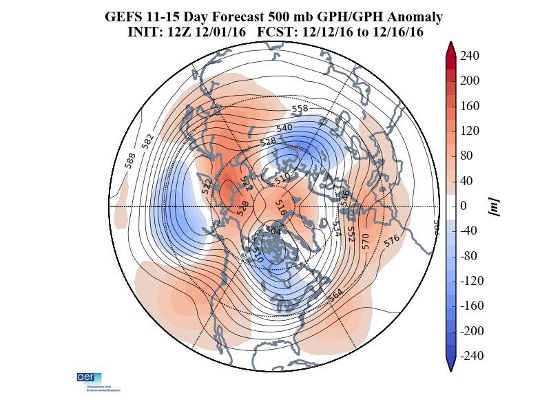
December 9th - 15th is pretty impressive. There is no denying that. Look at the magnitude of the Aleutian/Nina ridge in the western Arctic. There is also considerable, more then I expected, east-based blocking. I would be pretty disappointed if this period did not deliver a snow event for our area. For December, this is pretty damn good. We'll hope guidance continues to show this early next week.


Then by mid to late month, the pattern turns ugly according to the Weeklies. Raging +EPO which could turn the power back on for the Pacific Jet. Blocking dissipates and warmth overtakes the country as a result. Unfortunately, this pattern has merit and could actually become more anomalous by January but we'll cross that road when the time comes. 200CHI anomalies show convection developing in unfavorable regions of the Tropical Pacific too by the middle of the month. This would likely kick the Aleutian ridge out and replace it with a trough.
_________________
_______________________________________________________________________________________________________
CLICK HERE to view NJ Strong Snowstorm Classifications
Frank_Wx- Godzilla Seeker
- Posts : 21305
Reputation : 328
Join date : 2013-01-05
Age : 31
Location : Jersey City, NJ -
Re: Long Range Thread 12.0
![]() by Frank_Wx Thu Dec 01, 2016 10:13 pm
by Frank_Wx Thu Dec 01, 2016 10:13 pm
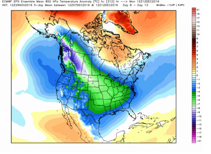
amugs wrote:GFS late to the cold party!!
12z
latest 18z
0z????coleder, hold serve?
Notice the coldest anomalies are in the west and central CONUS then modify by the time it hits the east coast. It will undoubtedly get cold, but we need to see a jet stream pattern conducive for developing low pressure systems.
_________________
_______________________________________________________________________________________________________
CLICK HERE to view NJ Strong Snowstorm Classifications
Frank_Wx- Godzilla Seeker
- Posts : 21305
Reputation : 328
Join date : 2013-01-05
Age : 31
Location : Jersey City, NJ -
Re: Long Range Thread 12.0
![]() by sroc4 Fri Dec 02, 2016 7:44 am
by sroc4 Fri Dec 02, 2016 7:44 am
Isotherm wrote:sroc4 wrote:Although I am still very hesitant to jump on any bandwagon that involves LR (10-14days out), there's this from Dr. Judah Cohan: Look at the west coast. Fingers crossed
Judah Cohen
@judah47
Party like its 2014! Latest GFS forecast of hemispheric atmospheric circulation reminiscent of #polarvortex winter of 2013/14, #cold East US
Need to get to DEc 7-9th. That is when hyped Aleutian poleward ridge (-WPO) is progged to be in full bloom. The cold is the first and most important ingredient to get the white gold. Poleward blocking will trigger the southward movement of the cold air masses.
To be honest Scott, over recent years, I've noticed a tendency with Dr. Cohen which, personally, has resulted in some loss of respect in terms of forecasting prowess. I respect him, but I think sometimes there can be a bit of a myopic focus on the October snow indicators. But that aside, I find myself on an island of negativity these days as I'm not all that excited about the pattern. Yes, the wave breaking is real and we'll see the poleward ridge, but what will be the mechanism to maintain it (there won't be IMO)? Contemporaneously, what will the NAM / NAO look like? Everything I see points to relatively weak wave driving in terms of the tropospheric precursor patterns and consequently a rapidly intensifying stratospheric vortex. My winter outlook primary favorable period was dec into potentially early jan, but I'm still not seeing signs of sustained -AO/NAO which will be deleterious in this Pacific regime.
I can understand what your saying Tom regarding Dr. Cohan. We all have our biasis I suppose; after all we are human. I have noticed that about many of the prominent mets in this business. Take JB for example. There is no denying the fact that the man is good at what he does when looking at LR forecasting, but there is also no denying the fact that he has his known biasis.
Regarding this island of negativity you refer to you have definitely not been on this island alone. I too have been either quiet because I have not believed the hype, (because mom always taught me if you have nothing nice to say don't say anything) or I myself in my thoughts/write ups through Nov have not been optimistic about the pattern as a whole either. My thoughts and ideas have def echoed your ideas regarding the big picture hence the precluding statement: I am still very hesitant to jump on any bandwagon that involves LR (10-14days out).
I did have a question regarding the poleward Aleutian ridging. The result of this blocking feature to the overall pattern, depending on how weak or strong, short lived or longer lived, I understand completely. However, it has been unclear to me exactly why, what seemingly was out of nowhere, this ridge feauture will go up when prev the broad trough in this location has dominated for much of the recent past. In your post a couple of days ago you mention the forcing mechanisms for this riding being related to "retracted jet/low GWO, Rossby wave trains via -VP". Can you define GWO, and VP is? And can you expand on why a low GWO helps to force the ridging, and why a -VP enhances the Rossby wave trains?
_________________
"In weather and in life, there's no winning and losing; there's only winning and learning."
WINTER 2012/2013 TOTALS 43.65"WINTER 2017/2018 TOTALS 62.85" WINTER 2022/2023 TOTALS 4.9"
WINTER 2013/2014 TOTALS 64.85"WINTER 2018/2019 TOTALS 14.25" WINTER 2023/2024 TOTALS 13.1"
WINTER 2014/2015 TOTALS 71.20"WINTER 2019/2020 TOTALS 6.35"
WINTER 2015/2016 TOTALS 35.00"WINTER 2020/2021 TOTALS 37.75"
WINTER 2016/2017 TOTALS 42.25"WINTER 2021/2022 TOTALS 31.65"
sroc4- Admin
- Posts : 8331
Reputation : 301
Join date : 2013-01-07
Location : Wading River, LI
Re: Long Range Thread 12.0
![]() by amugs Fri Dec 02, 2016 8:09 am
by amugs Fri Dec 02, 2016 8:09 am
Frank_Wx wrote:amugs wrote:GFS late to the cold party!!
12z
latest 18z
0z????coleder, hold serve?
Notice the coldest anomalies are in the west and central CONUS then modify by the time it hits the east coast. It will undoubtedly get cold, but we need to see a jet stream pattern conducive for developing low pressure systems.
Of course they are going to modify they are traveling some 2000 plus miles over bare ground and teh cold air source is being dumped over Alaska and funnelled through the passageway developed over Al and N CAN. BUT i'll take it. Better than what we have and my point being the GFS is late or coming around to teh cold look regime about to set up albeit transient but for the time being it is UNLIKE the Dec we have around here for some time.
_________________
Mugs
AKA:King: Snow Weenie
Self Proclaimed
WINTER 2014-15 : 55.12" +.02 for 6 coatings (avg. 35")
WINTER 2015-16 Total - 29.8" (Avg 35")
WINTER 2016-17 : 39.5" so far
amugs- Advanced Forecaster - Mod
- Posts : 15093
Reputation : 213
Join date : 2013-01-07
Age : 54
Location : Hillsdale,NJ
Re: Long Range Thread 12.0
![]() by dkodgis Fri Dec 02, 2016 9:12 am
by dkodgis Fri Dec 02, 2016 9:12 am

dkodgis- Senior Enthusiast
- Posts : 2504
Reputation : 98
Join date : 2013-12-29
Re: Long Range Thread 12.0
![]() by amugs Fri Dec 02, 2016 9:15 am
by amugs Fri Dec 02, 2016 9:15 am
.png)
_________________
Mugs
AKA:King: Snow Weenie
Self Proclaimed
WINTER 2014-15 : 55.12" +.02 for 6 coatings (avg. 35")
WINTER 2015-16 Total - 29.8" (Avg 35")
WINTER 2016-17 : 39.5" so far
amugs- Advanced Forecaster - Mod
- Posts : 15093
Reputation : 213
Join date : 2013-01-07
Age : 54
Location : Hillsdale,NJ
Re: Long Range Thread 12.0
![]() by algae888 Fri Dec 02, 2016 9:20 am
by algae888 Fri Dec 02, 2016 9:20 am
there is no sign of any warmth from today until dec 16th at the earliest. any pos dep. will be slight. also day 10-15 eps looks to bring back the -nao and is slow with breaking down the Aleution ridge. should be a fun few weeks. if we don't snow it will at least feel like December.dkodgis wrote:Things do look interesting by the middle to end of next week regarding moisture and cold, maybe enough for snow. But help a senior citizen out. Did I read here or elsewhere 60's may come back after that?

algae888- Advanced Forecaster
- Posts : 5311
Reputation : 46
Join date : 2013-02-05
Age : 61
Location : mt. vernon, new york
Page 29 of 40 • 1 ... 16 ... 28, 29, 30 ... 34 ... 40 ![]()
|
|
|