
 Search
Long Range Thread 12.0
Page 30 of 40 •  1 ... 16 ... 29, 30, 31 ... 35 ... 40
 ![]()
Re: Long Range Thread 12.0
![]() by amugs Fri Dec 02, 2016 9:15 am
by amugs Fri Dec 02, 2016 9:15 am
.png)
amugs- Advanced Forecaster - Mod

- Posts : 15093
Join date : 2013-01-07
Re: Long Range Thread 12.0
![]() by algae888 Fri Dec 02, 2016 9:20 am
by algae888 Fri Dec 02, 2016 9:20 am
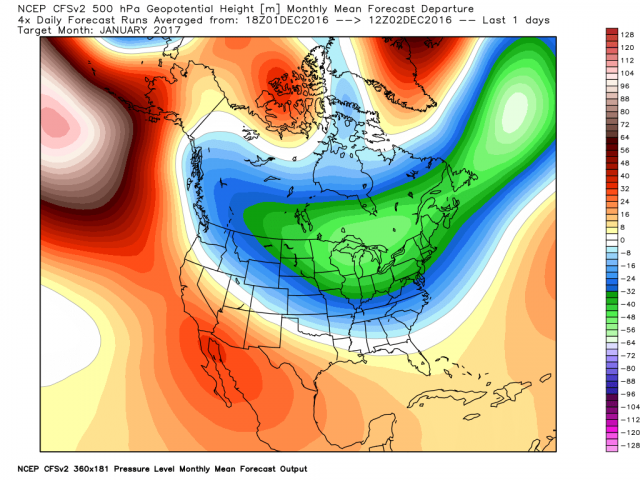
there is no sign of any warmth from today until dec 16th at the earliest. any pos dep. will be slight. also day 10-15 eps looks to bring back the -nao and is slow with breaking down the Aleution ridge. should be a fun few weeks. if we don't snow it will at least feel like December.dkodgis wrote:Things do look interesting by the middle to end of next week regarding moisture and cold, maybe enough for snow. But help a senior citizen out. Did I read here or elsewhere 60's may come back after that?

algae888- Advanced Forecaster

- Posts : 5311
Join date : 2013-02-05
Re: Long Range Thread 12.0
![]() by Frank_Wx Fri Dec 02, 2016 9:26 am
by Frank_Wx Fri Dec 02, 2016 9:26 am
dkodgis wrote:Things do look interesting by the middle to end of next week regarding moisture and cold, maybe enough for snow. But help a senior citizen out. Did I read here or elsewhere 60's may come back after that?
No...but I guess 50's could return mid to late month.
_________________
_______________________________________________________________________________________________________
CLICK HERE to view NJ Strong Snowstorm Classifications

Frank_Wx- Godzilla Seeker

- Posts : 21305
Reputation : 328
Join date : 2013-01-05
Age : 31
Location : Jersey City, NJ -

Re: Long Range Thread 12.0
![]() by sroc4 Fri Dec 02, 2016 9:55 am
by sroc4 Fri Dec 02, 2016 9:55 am
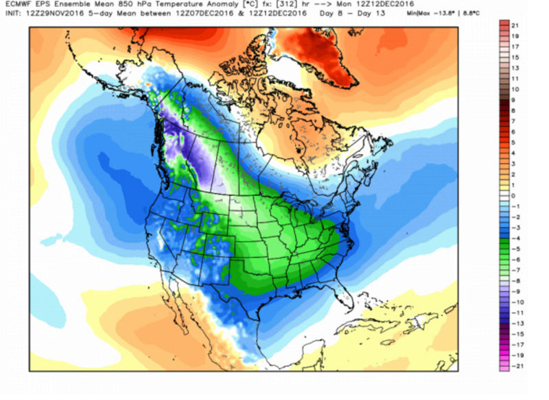
amugs wrote:Look at how much colder this is trending
Trending colder in the mid section of the country but overall in the NE it trended oposite, at least for that weeks anomalies. Yes in theory it should bleed east, but will it? Or will the SE ridge cont to keep the coldest anomalies west of the apps? Remember these weekly snapshots are avgs for the week. The colder mid section but slight warmer along the Mid atlantic and NE may be an indicator that we get cutters with warm sectoring. Just a devil advocates point of view. There is no doubt we will be colder than we have been during this time frame overall.
_________________
"In weather and in life, there's no winning and losing; there's only winning and learning."
WINTER 2012/2013 TOTALS 43.65"WINTER 2017/2018 TOTALS 62.85" WINTER 2022/2023 TOTALS 4.9"
WINTER 2013/2014 TOTALS 64.85"WINTER 2018/2019 TOTALS 14.25" WINTER 2023/2024 TOTALS 13.1"
WINTER 2014/2015 TOTALS 71.20"WINTER 2019/2020 TOTALS 6.35"
WINTER 2015/2016 TOTALS 35.00"WINTER 2020/2021 TOTALS 37.75"
WINTER 2016/2017 TOTALS 42.25"WINTER 2021/2022 TOTALS 31.65"

sroc4- Admin
- Posts : 8331
Reputation : 301
Join date : 2013-01-07
Location : Wading River, LI
Re: Long Range Thread 12.0
![]() by Snow88 Fri Dec 02, 2016 9:57 am
by Snow88 Fri Dec 02, 2016 9:57 am
The pattern looks good moving forward

Snow88- Senior Enthusiast

- Posts : 2193
Reputation : 4
Join date : 2013-01-09
Age : 35
Location : Brooklyn, NY
Re: Long Range Thread 12.0
![]() by jake732 Fri Dec 02, 2016 10:31 am
by jake732 Fri Dec 02, 2016 10:31 am

jake732- Pro Enthusiast

- Posts : 449
Reputation : 0
Join date : 2016-01-03
Location : lakewood, nj -
Re: Long Range Thread 12.0
![]() by sroc4 Fri Dec 02, 2016 10:35 am
by sroc4 Fri Dec 02, 2016 10:35 am
Snow88 wrote:A lot of doom and gloom out there in regards to this pattern
The pattern looks good moving forward
Doom and gloom on some of the other site Anthony. You know where im talking about. The weenies that interpret the LR every 6hrs, and evaluate changes fom run to run like its gospel. They portray gloom and doom. This site is more of a cautiousness undertone for very legitimate reasoning looking at large scale pattern vs run to run variances.
Regarding the pattern it looks good but not great. We def need the cold if we are going to have anything to work with regarding snow chances, and I will def agree for at least a brief period we look to get, but even that hasnt happened yet. I will reiterate, we have to see how the poleward ridging sets up in reality, and the what happens going forward, will show itself more clearly...for me at least. People who think they have it nailed down beyond the 7-10th time frame are fooling themselves.
_________________
"In weather and in life, there's no winning and losing; there's only winning and learning."
WINTER 2012/2013 TOTALS 43.65"WINTER 2017/2018 TOTALS 62.85" WINTER 2022/2023 TOTALS 4.9"
WINTER 2013/2014 TOTALS 64.85"WINTER 2018/2019 TOTALS 14.25" WINTER 2023/2024 TOTALS 13.1"
WINTER 2014/2015 TOTALS 71.20"WINTER 2019/2020 TOTALS 6.35"
WINTER 2015/2016 TOTALS 35.00"WINTER 2020/2021 TOTALS 37.75"
WINTER 2016/2017 TOTALS 42.25"WINTER 2021/2022 TOTALS 31.65"
sroc4- Admin
- Posts : 8331
Reputation : 301
Join date : 2013-01-07
Location : Wading River, LI
Re: Long Range Thread 12.0
![]() by algae888 Fri Dec 02, 2016 11:01 am
by algae888 Fri Dec 02, 2016 11:01 am

algae888- Advanced Forecaster
- Posts : 5311
Reputation : 46
Join date : 2013-02-05
Age : 61
Location : mt. vernon, new york
Re: Long Range Thread 12.0
![]() by Frank_Wx Fri Dec 02, 2016 11:44 am
by Frank_Wx Fri Dec 02, 2016 11:44 am

_________________
_______________________________________________________________________________________________________
CLICK HERE to view NJ Strong Snowstorm Classifications
Frank_Wx- Godzilla Seeker
- Posts : 21305
Reputation : 328
Join date : 2013-01-05
Age : 31
Location : Jersey City, NJ -
Re: Long Range Thread 12.0
![]() by amugs Fri Dec 02, 2016 11:49 am
by amugs Fri Dec 02, 2016 11:49 am
Bring the cold and then we go from there - cold looks very promising just need a bit more help. I think we will evolve into such but time will tell.
Hard Freeze for Gulf Coast from Maue's maps - Madonne they go from Tornados to Frigid in about 7 days!!


_________________
Mugs
AKA:King: Snow Weenie
Self Proclaimed
WINTER 2014-15 : 55.12" +.02 for 6 coatings (avg. 35")
WINTER 2015-16 Total - 29.8" (Avg 35")
WINTER 2016-17 : 39.5" so far

amugs- Advanced Forecaster - Mod
- Posts : 15093
Reputation : 213
Join date : 2013-01-07
Age : 54
Location : Hillsdale,NJ
Re: Long Range Thread 12.0
![]() by Frank_Wx Fri Dec 02, 2016 11:54 am
by Frank_Wx Fri Dec 02, 2016 11:54 am
_________________
_______________________________________________________________________________________________________
CLICK HERE to view NJ Strong Snowstorm Classifications
Frank_Wx- Godzilla Seeker
- Posts : 21305
Reputation : 328
Join date : 2013-01-05
Age : 31
Location : Jersey City, NJ -
Re: Long Range Thread 12.0
![]() by amugs Fri Dec 02, 2016 1:57 pm
by amugs Fri Dec 02, 2016 1:57 pm
This is the reason why we wil get cold and for the heartland frigid - the hard freeze goes down to Mexico - YIKES!!
Wed Nov 23rd

Today - MOMMA MIA!!
_________________
Mugs
AKA:King: Snow Weenie
Self Proclaimed
WINTER 2014-15 : 55.12" +.02 for 6 coatings (avg. 35")
WINTER 2015-16 Total - 29.8" (Avg 35")
WINTER 2016-17 : 39.5" so far
amugs- Advanced Forecaster - Mod
- Posts : 15093
Reputation : 213
Join date : 2013-01-07
Age : 54
Location : Hillsdale,NJ
Re: Long Range Thread 12.0
![]() by amugs Fri Dec 02, 2016 2:37 pm
by amugs Fri Dec 02, 2016 2:37 pm
_________________
Mugs
AKA:King: Snow Weenie
Self Proclaimed
WINTER 2014-15 : 55.12" +.02 for 6 coatings (avg. 35")
WINTER 2015-16 Total - 29.8" (Avg 35")
WINTER 2016-17 : 39.5" so far
amugs- Advanced Forecaster - Mod
- Posts : 15093
Reputation : 213
Join date : 2013-01-07
Age : 54
Location : Hillsdale,NJ
Re: Long Range Thread 12.0
![]() by amugs Fri Dec 02, 2016 2:40 pm
by amugs Fri Dec 02, 2016 2:40 pm
_________________
Mugs
AKA:King: Snow Weenie
Self Proclaimed
WINTER 2014-15 : 55.12" +.02 for 6 coatings (avg. 35")
WINTER 2015-16 Total - 29.8" (Avg 35")
WINTER 2016-17 : 39.5" so far
amugs- Advanced Forecaster - Mod
- Posts : 15093
Reputation : 213
Join date : 2013-01-07
Age : 54
Location : Hillsdale,NJ
Re: Long Range Thread 12.0
![]() by sroc4 Sat Dec 03, 2016 7:29 am
by sroc4 Sat Dec 03, 2016 7:29 am
rb924119 wrote:Can't really elaborate right now because my free time is dwindling tonight, but I'm back on my normal internet connection and my video from yesterday uploaded in less than a minute ahaha please visit the link below to watch it. Also, please note that this video was tailored to a less knowledgeable audience, which is why I don't go as in depth and it's shorter. If I can, I'll post an update/more detailed analysis of my thoughts. Also becoming interested in a possible overrunning event for Tuesday-Wednesday. Questions, comments, concerns, let me know!!
https://drive.google.com/open?id=0Byod2Sk27yNYZ3AzUVdMa0Y1TFk
Hey Ray I finally had a chance this am to watch your video. In reality I actually forgot about, but when I was looking at the models this am for the sneaky little over running event you and Al had been talking about before I posted my thoughts I wanted to actually hear what you had to say as to make sure I give credit where credit is due.
I still want to see another 24hrs before I make any definitive statements. Ill use a phrase that Frank likes to use..."Mood Flakes" to describe Monday. I can see a scenario where even the immediate coast sees mood flakes if things trend a little better. Here are a few things to monitor over the next 24hr
1) 850mb temps look to be plenty cold throughout the time frame the precip moves though
2) 925mb temps are cold to start and remain marginal along the immediate coast but appear as of now to remain below freezing throughout the precip N&W
3) Dew points at the start of the precip look like they are in the mid to upper twenties or maybe lower 30 at the start of the precip; however as currently modeled dew points quickly rise to upper 30's and even low fourties depending on the individual model you look at, highest along the coast
4) Surface temps begin around freezing or just below N & W and are just abve freezing (mid 30's +/-) along the coast at the start, but as the precip moves in there is a warm surge in the modeling
5) Vertical velocities aren't exactly screaming strong upward motion, but they are between -5 to -10
6) Total QPF itself has trended less and less over the last few runs. We need precip to trend a little heavier, esp for coastal plain to have a chance at wet bulbing/dynamic cooling and "mood flakes to fly
One of the problems is the energy at 850mb and 500mb remains spread out so it becomes difficult to gget good dynamics. That that said with the 850 and 925mb temps looking pretty good area wide what I would like to see in the shorter term hi res models is for 1) the precip trend a little heavier. This would force dynamic cooling at the surface as the air temp attempts to approach the lower dew point temp as heavier precip falls, and snow would make it to the ground even at the coast. I do not see any chance at accumulations along the coast in pretty much any scenario at this time; however. 2) If vertical velocities trend a little stronger we may just get that heavier precip.
Overall N & W Of say I-278 I see a 85-95% chance at "Mood flakes" with maybe a dusting to light accumulation on grassy surfaces and even pavement if precip is heavy enough, and for the immediate coast I say 25-50% chance at "mood flakes". Mixing is still likely over our entire coverage are at some point however. One finalthought...cold air tends to win over warm air because its more dense and harder to scour out so don't be surprised to see the hi res modeling trend better as we get in close.
_________________
"In weather and in life, there's no winning and losing; there's only winning and learning."
WINTER 2012/2013 TOTALS 43.65"WINTER 2017/2018 TOTALS 62.85" WINTER 2022/2023 TOTALS 4.9"
WINTER 2013/2014 TOTALS 64.85"WINTER 2018/2019 TOTALS 14.25" WINTER 2023/2024 TOTALS 13.1"
WINTER 2014/2015 TOTALS 71.20"WINTER 2019/2020 TOTALS 6.35"
WINTER 2015/2016 TOTALS 35.00"WINTER 2020/2021 TOTALS 37.75"
WINTER 2016/2017 TOTALS 42.25"WINTER 2021/2022 TOTALS 31.65"
sroc4- Admin
- Posts : 8331
Reputation : 301
Join date : 2013-01-07
Location : Wading River, LI
Re: Long Range Thread 12.0
![]() by rb924119 Sat Dec 03, 2016 9:06 am
by rb924119 Sat Dec 03, 2016 9:06 am
1. and 2.: Yeah, the thermal profiles look decent for most of the event for most areas, save the immediate coast, with best chances of more "significant" accumulations north and west of I-95, as well as regions north of a line from Harrisburg, PA, through Trenton, NJ. I fully agree.
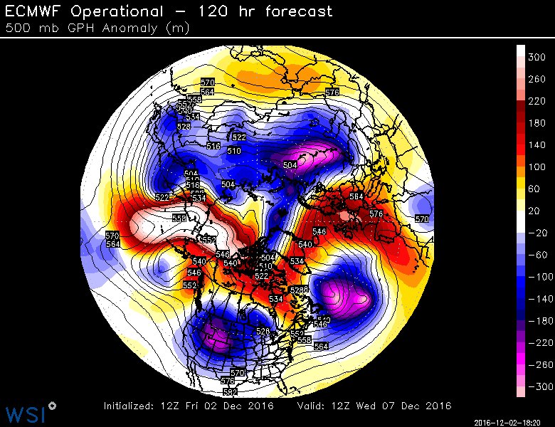
3. and 4.: The dew points "dew" rise (sorry, couldn't resist that lmao), but not until AFTER about 14z, which by that point, the precip is already shutting down. Don't forget, much of this will fall at night or early morning, so that spike is almost meaningless. Also, take a look at your pressure fields (well, these are the anomalies because the gradient is pretty weak) during the "heart" of the event, posted below:
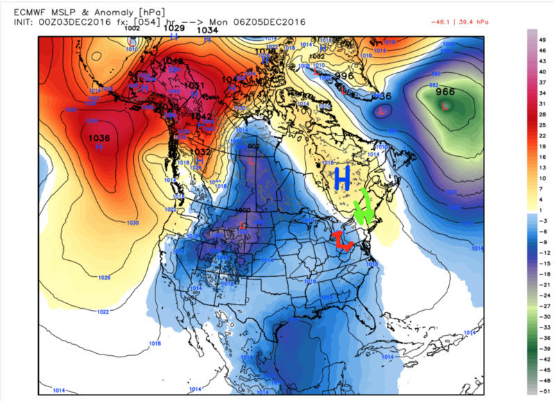
Note the higher pressure anomalies to the north associated with the higher pressure of the colder air, as well as the anomalies associated with our system of interest. Those anomalies will work to drive the colder, drier air southward, so this supports the argument that the dew points and temperatures should stay on the cooler side of guidance during the event. Those anomalies only move away, and the pressure gradient cease to work in our favor, once the system is through.
Combine the support of that anomaly field with the fact that the air temperatures will have already been working to lower the ground temperatures for the 48 hours prior, once you have temperatures even in the mid-30's, without solar radiation, and even light snow, accumulations will likely start on the colder surfaces (grass, trees, cars, etc.).
5. You are absolutely correct in saying that vertical velocities are not impressive, largely because the mid-level energy is so unorganized AND there is no jet help. BUT, let me pose a counter to that. Take a look at the 500 hPa setup valid 06z Monday:

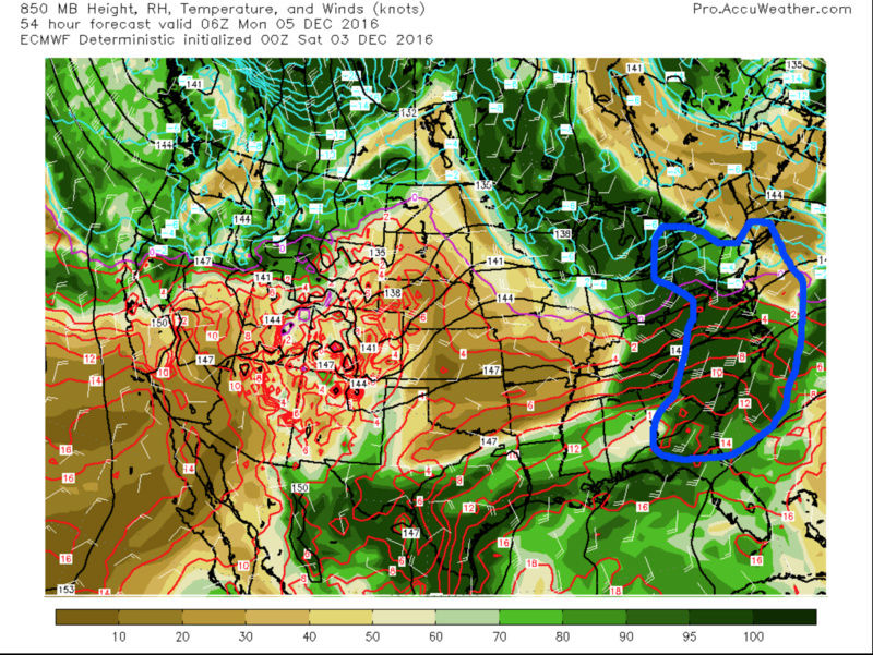
The region outlined in blue is where the strongest positive vorticity advection, forcing for ascent, is occurring. So, that's where our mid-level forcing is. But now take a look at your low-level (850 hPa) forcing, valid for the same time:
The area of best warm advection (upglide, isentropic, overrunning) forcing for ascent is outlined in blue.
Here's 700 hPa, although valid at 00z Monday, because it's easier to demonstrate my point. It's still present at 06z, but is beginning to take on more of a frontal and linear appearance, so it makes the connection that I'm about to make a bit more abstract.
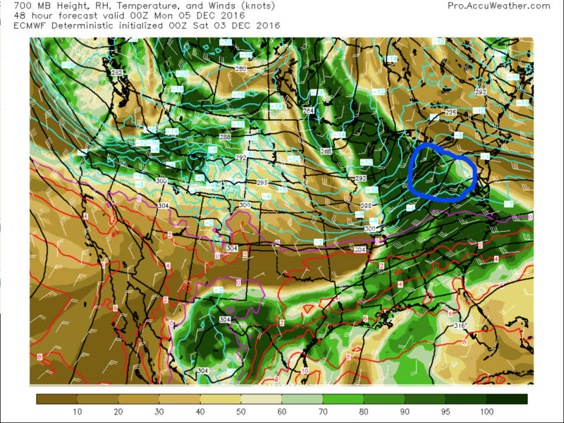
Taking a look at these in sequence, again, keep in mind that the 700 hPa warm advection/upglide/isentropic forcing shown is six hours prior to 500 hPa and 850 hPa, but you can visually extrapolate that through, it looks like this:
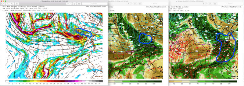
If we overlap them, this is the precipitation field that I would expect to see (bottom panel):

Where the northern blue region will be a shield of mainly light snow, with a few embedded regions of moderate snow. Now, it may not be a full stratiform shield; it could very well be showery, but I DO think there will be more precipitation returns on radar than blank returns. The red denotes a region of reduced or more spotty precipitation, since that's in a "no man's land" region of forcing (or lack thereof), and then the southern blue region will be rain that's forced from strong isentropic, warm advection, upglide processes.
You can argue that "Well, you're only looking at the EURO, which is one of the few models right now supporting your claims." You're right, but my counter to that is that when you analyze the situations across the models, they are all depicting the same forcings and in the same regions with the same setup. My argument is that they are not picking up on the amount to which these forcings will positively interact, which is why they are depicting less precipitation. I contend that even though the 850 hPa warm advection/isentropic/upglide forcing is separate from that at 500 hPa, by seeing the warm advection forcing also occurring at 700 hPa, it's showing that the low-level (850 hPa) warm advection will be sustained further north as it lifts to 700 hPa. Once it reaches the 500 hPa level, it will then feel the effects of the southern fringe of the 500 hPa vorticity advection forcing, resulting in further ascent. It will not be abrupt ascent; it will be gradual. But when you note the source region of the advection, which is at the very least in the Mid-South/Southeast coastal plain, that air contains a lot more moisture relative to our air, so even though the ascent is weak and gradual, it will not take much to begin the precipitation processes for our area. Likewise, for the regions that I outlined in my video, the very low-level (sub-850 hPa) advection of colder, drier air via the pressure gradient force from the higher pressures to our north should overwrite the warm advection for most of the event and allow snow to fall and accumulate some. I am also banking on the fact that every system that has come into the Northeast has trended deeper in the short range, which would a) increase the amount of forcings already present, but also expand them further south. It's just a hunch, though. However, even if it doesn't, I still think there will be enough of the forcing mechanisms present to allow a more expansive precipitation field to develop than most medium-range guidance is currently suggesting. I like the EURO here, and I am expecting the rest of the guidance, as well as the short-range models to start picking up on this and trend a bit wetter, just like the last one.
rb924119- Meteorologist

- Posts : 6889
Reputation : 194
Join date : 2013-02-06
Age : 32
Location : Greentown, Pa
Re: Long Range Thread 12.0
![]() by Frank_Wx Sat Dec 03, 2016 9:36 am
by Frank_Wx Sat Dec 03, 2016 9:36 am
I'm much more interested in a potential event between the 12th and 18th when the pattern amplifies.
_________________
_______________________________________________________________________________________________________
CLICK HERE to view NJ Strong Snowstorm Classifications
Frank_Wx- Godzilla Seeker
- Posts : 21305
Reputation : 328
Join date : 2013-01-05
Age : 31
Location : Jersey City, NJ -
Re: Long Range Thread 12.0
![]() by rb924119 Sat Dec 03, 2016 9:41 am
by rb924119 Sat Dec 03, 2016 9:41 am
Frank_Wx wrote:@Ray - had a chance to watch your video. Thanks for posting. Yea, it looks like NW NJ and NEPA could see some mood flakes. Not sure I'm buying any accumulations only because the energy is so weak, surface temps and the air in general is marginal. The NAM this morning showed exactly that.
I'm much more interested in a potential event between the 12th and 18th when the pattern amplifies.
Thanks for watching, I'm glad you got it to work!! Very well could be nothing more than that, but I'm just suspicious, because I've seen this type of setup before. Also, the Tuesday-Wednesday system has to be watched because I think it's going to be wintry for our area based on the synoptic setup. I'll elaborate more on this probably tomorrow, since I may be doing a map today aha
rb924119- Meteorologist
- Posts : 6889
Reputation : 194
Join date : 2013-02-06
Age : 32
Location : Greentown, Pa
Re: Long Range Thread 12.0
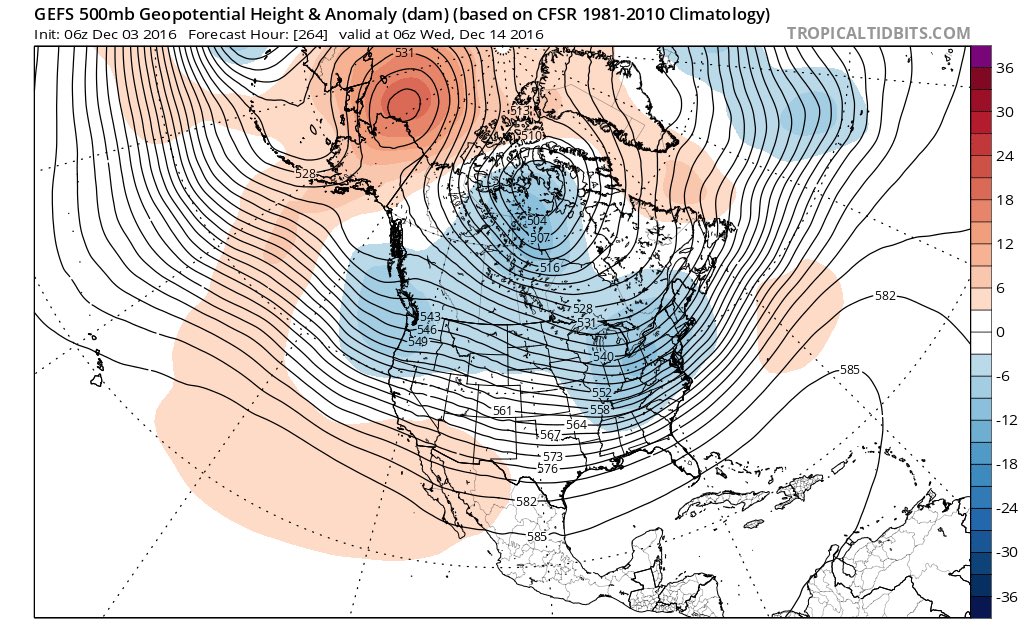
![]() by amugs Sat Dec 03, 2016 10:02 am
by amugs Sat Dec 03, 2016 10:02 am
Ray,
Excellent technical write up adn well explained - loved teh video too. I am for one recognizing this same with our systems since mid October that they seem to be wetter than modelled and lasting longer overall. I applaud your expertise and believe this trend will grow as we move through the greatest season of all - WINTER!!
Now back to teh cold - look at the EPS which to me has been outstanding showing this evolution of pattern we are entering.

Cold builds again in NW Canada due to WPO Ridge

GEFS see it to LR
_________________
Mugs
AKA:King: Snow Weenie
Self Proclaimed
WINTER 2014-15 : 55.12" +.02 for 6 coatings (avg. 35")
WINTER 2015-16 Total - 29.8" (Avg 35")
WINTER 2016-17 : 39.5" so far
amugs- Advanced Forecaster - Mod
- Posts : 15093
Reputation : 213
Join date : 2013-01-07
Age : 54
Location : Hillsdale,NJ
Re: Long Range Thread 12.0
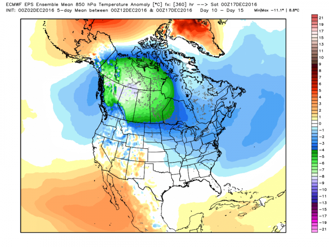
![]() by amugs Sat Dec 03, 2016 10:50 am
by amugs Sat Dec 03, 2016 10:50 am
EPS, GFS and GEM in this order from left to right
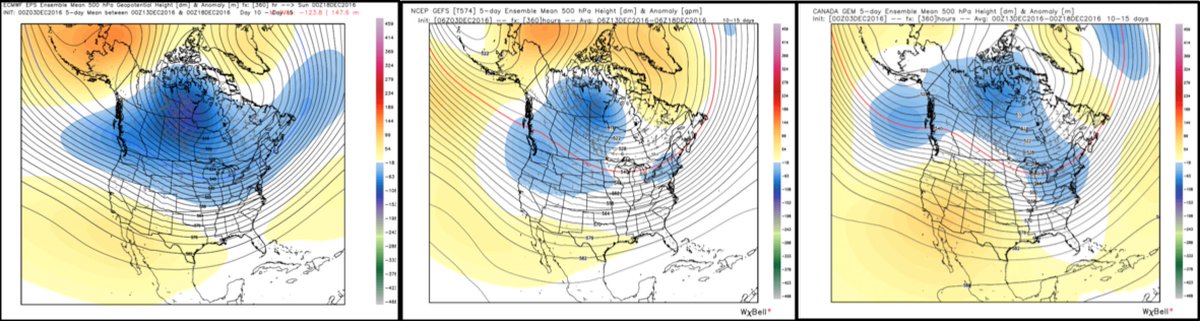
Looka the GEFS MADONNEEEEEE this is crazy cold now!!
6Z
.png)
_________________
Mugs
AKA:King: Snow Weenie
Self Proclaimed
WINTER 2014-15 : 55.12" +.02 for 6 coatings (avg. 35")
WINTER 2015-16 Total - 29.8" (Avg 35")
WINTER 2016-17 : 39.5" so far
amugs- Advanced Forecaster - Mod
- Posts : 15093
Reputation : 213
Join date : 2013-01-07
Age : 54
Location : Hillsdale,NJ
Re: Long Range Thread 12.0
![]() by amugs Sat Dec 03, 2016 10:51 am
by amugs Sat Dec 03, 2016 10:51 am
_________________
Mugs
AKA:King: Snow Weenie
Self Proclaimed
WINTER 2014-15 : 55.12" +.02 for 6 coatings (avg. 35")
WINTER 2015-16 Total - 29.8" (Avg 35")
WINTER 2016-17 : 39.5" so far
amugs- Advanced Forecaster - Mod
- Posts : 15093
Reputation : 213
Join date : 2013-01-07
Age : 54
Location : Hillsdale,NJ
Re: Long Range Thread 12.0
![]() by Isotherm Sat Dec 03, 2016 11:18 am
by Isotherm Sat Dec 03, 2016 11:18 am
sroc4 wrote:Isotherm wrote:sroc4 wrote:Although I am still very hesitant to jump on any bandwagon that involves LR (10-14days out), there's this from Dr. Judah Cohan: Look at the west coast. Fingers crossed
Judah Cohen
@judah47
Party like its 2014! Latest GFS forecast of hemispheric atmospheric circulation reminiscent of #polarvortex winter of 2013/14, #cold East US
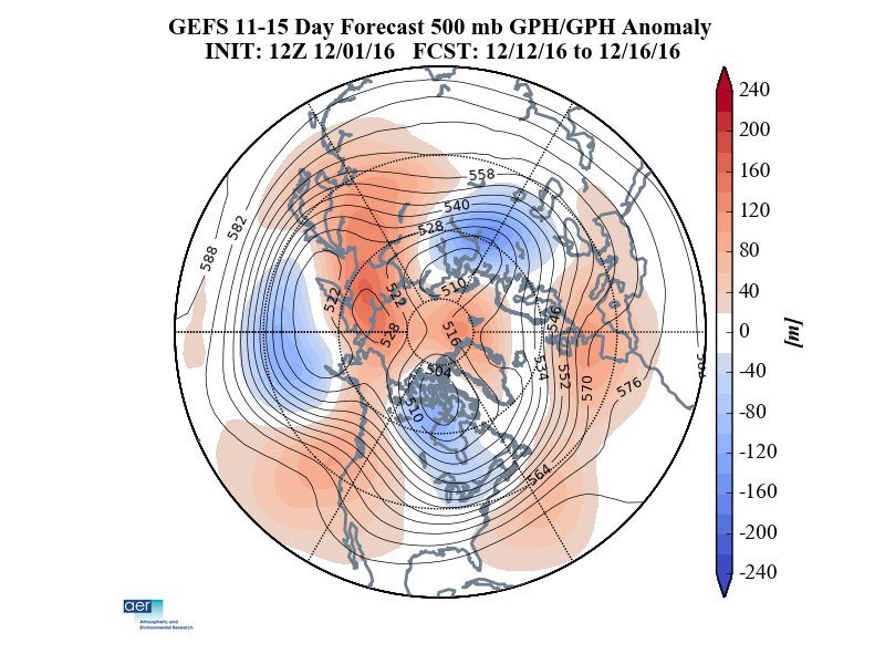
Need to get to DEc 7-9th. That is when hyped Aleutian poleward ridge (-WPO) is progged to be in full bloom. The cold is the first and most important ingredient to get the white gold. Poleward blocking will trigger the southward movement of the cold air masses.
To be honest Scott, over recent years, I've noticed a tendency with Dr. Cohen which, personally, has resulted in some loss of respect in terms of forecasting prowess. I respect him, but I think sometimes there can be a bit of a myopic focus on the October snow indicators. But that aside, I find myself on an island of negativity these days as I'm not all that excited about the pattern. Yes, the wave breaking is real and we'll see the poleward ridge, but what will be the mechanism to maintain it (there won't be IMO)? Contemporaneously, what will the NAM / NAO look like? Everything I see points to relatively weak wave driving in terms of the tropospheric precursor patterns and consequently a rapidly intensifying stratospheric vortex. My winter outlook primary favorable period was dec into potentially early jan, but I'm still not seeing signs of sustained -AO/NAO which will be deleterious in this Pacific regime.
I can understand what your saying Tom regarding Dr. Cohan. We all have our biasis I suppose; after all we are human. I have noticed that about many of the prominent mets in this business. Take JB for example. There is no denying the fact that the man is good at what he does when looking at LR forecasting, but there is also no denying the fact that he has his known biasis.
Regarding this island of negativity you refer to you have definitely not been on this island alone. I too have been either quiet because I have not believed the hype, (because mom always taught me if you have nothing nice to say don't say anything) or I myself in my thoughts/write ups through Nov have not been optimistic about the pattern as a whole either. My thoughts and ideas have def echoed your ideas regarding the big picture hence the precluding statement: I am still very hesitant to jump on any bandwagon that involves LR (10-14days out).
I did have a question regarding the poleward Aleutian ridging. The result of this blocking feature to the overall pattern, depending on how weak or strong, short lived or longer lived, I understand completely. However, it has been unclear to me exactly why, what seemingly was out of nowhere, this ridge feauture will go up when prev the broad trough in this location has dominated for much of the recent past. In your post a couple of days ago you mention the forcing mechanisms for this riding being related to "retracted jet/low GWO, Rossby wave trains via -VP". Can you define GWO, and VP is? And can you expand on why a low GWO helps to force the ridging, and why a -VP enhances the Rossby wave trains?
Yes, you have been quite skeptical as well, and we have largely been in agreement on the evolution here. A couple of significant alterations have occurred insofar as the hemispheric jet configuration, momentum budget, as well as the mean z200 velocity potential (VP) pattern. The global wind oscillation (GWO) has 8 phases, and the low number phases coincide with a suppressed atmospheric angular momentum budget. When momentum is removed, the global circulation slows down, and consequently, the Pacific jet tends to enter a retracted state whereby dateline ridging more effectively develops. Additionally, the z200 velocity potential patterns are suggestive of large scale divergence/convergence zones in the upper levels which strongly modulate the tropical and extratropical ridge/trough pattern through latent heat production, expansion of heights / tightening/strengthening of jets, and initiation of Rossby waves which can emanate from tropical convection. These Rossby waves can also force cut-off blocks to develop by breaking poleward, as we see progged, and can vertically propagate into the stratosphere, perturbing the vortex there. The z200 velocity potential orientation is different right now vs the past couple months which is promoting the aforementioned processes, ultimately resulting in poleward/Aleutian ridging. Let me know if that disambiguates it.
Isotherm- Advanced Forecaster
- Posts : 231
Reputation : 4
Join date : 2014-09-01
Age : 33
Location : Monmouth County, NJ -
Re: Long Range Thread 12.0
![]() by Frank_Wx Sat Dec 03, 2016 11:54 am
by Frank_Wx Sat Dec 03, 2016 11:54 am

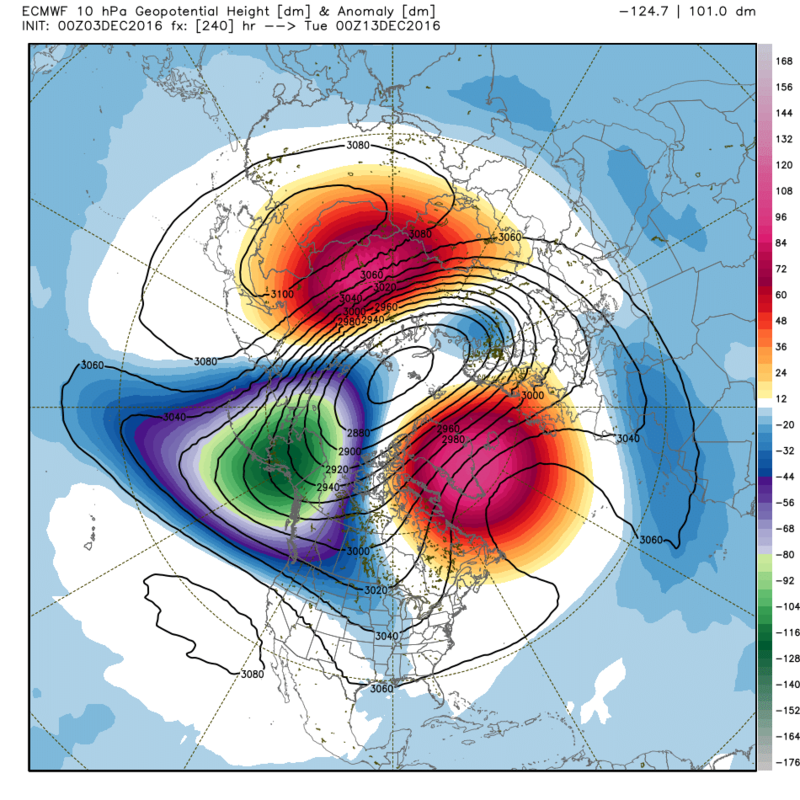
Here is the ECM OP 10hPa at Day 10. Vortex is looking pretty elongated there.
_________________
_______________________________________________________________________________________________________
CLICK HERE to view NJ Strong Snowstorm Classifications
Frank_Wx- Godzilla Seeker
- Posts : 21305
Reputation : 328
Join date : 2013-01-05
Age : 31
Location : Jersey City, NJ -
Re: Long Range Thread 12.0
![]() by Frank_Wx Sat Dec 03, 2016 12:04 pm
by Frank_Wx Sat Dec 03, 2016 12:04 pm

_________________
_______________________________________________________________________________________________________
CLICK HERE to view NJ Strong Snowstorm Classifications
Frank_Wx- Godzilla Seeker
- Posts : 21305
Reputation : 328
Join date : 2013-01-05
Age : 31
Location : Jersey City, NJ -
Re: Long Range Thread 12.0
![]() by hyde345 Sat Dec 03, 2016 12:05 pm
by hyde345 Sat Dec 03, 2016 12:05 pm

hyde345- Pro Enthusiast
- Posts : 1082
Reputation : 48
Join date : 2013-01-08
Location : Hyde Park, NY
Re: Long Range Thread 12.0
![]() by Frank_Wx Sat Dec 03, 2016 12:13 pm
by Frank_Wx Sat Dec 03, 2016 12:13 pm
hyde345 wrote:Really can't trust any of these models beyond 5 days. 6z and 12z runs of GFS look like night and day in LR.
Ain't that the truth.
Today's 12z GFS now shows a +EPO/+NAO developing which would allow storms to continue cutting to our west, keeping us mild and dry. It would be a Mild-Rain-Cold pattern.
_________________
_______________________________________________________________________________________________________
CLICK HERE to view NJ Strong Snowstorm Classifications
Frank_Wx- Godzilla Seeker
- Posts : 21305
Reputation : 328
Join date : 2013-01-05
Age : 31
Location : Jersey City, NJ -
Re: Long Range Thread 12.0
![]() by Isotherm Sat Dec 03, 2016 12:45 pm
by Isotherm Sat Dec 03, 2016 12:45 pm
Also, note the tropospheric teleconnections now indicating a +NAO/AO in the medium term on the ECMWF ensembles, reflective of the rapidly strengthening z10 zonal winds.

Isotherm- Advanced Forecaster
- Posts : 231
Reputation : 4
Join date : 2014-09-01
Age : 33
Location : Monmouth County, NJ -
Page 30 of 40 • 1 ... 16 ... 29, 30, 31 ... 35 ... 40 ![]()
|
|
|