
 Search
January 22nd-24th Nor'easter Observations & Discussions
Page 14 of 43 •  1 ... 8 ... 13, 14, 15 ... 28 ... 43
 ![]()
Re: January 22nd-24th Nor'easter Observations & Discussions
![]() by amugs Sun Jan 22, 2017 1:34 pm
by amugs Sun Jan 22, 2017 1:34 pm
Much more frozen precip N&W - cutoff is BC/ PC line in NNJ.


Wetter TOOOOOO!!
amugs- Advanced Forecaster - Mod

- Posts : 15093
Join date : 2013-01-07
Re: January 22nd-24th Nor'easter Observations & Discussions
![]() by mikeypizano Sun Jan 22, 2017 2:23 pm
by mikeypizano Sun Jan 22, 2017 2:23 pm
mikeypizano- Pro Enthusiast

- Posts : 1118
Join date : 2017-01-05
Re: January 22nd-24th Nor'easter Observations & Discussions
![]() by billg315 Sun Jan 22, 2017 2:29 pm
by billg315 Sun Jan 22, 2017 2:29 pm
mikeypizano wrote:Hoping we see some decent snow in the Wyoming Valley, but I am not sure if we will.
You've got better odds there than we do over here in NJ. And with the colder trend, I wouldn't write off the possibility of snow for your area.

billg315- Advanced Forecaster - Mod
- Posts : 4469
Reputation : 185
Join date : 2015-01-24
Age : 50
Location : Flemington, NJ
Re: January 22nd-24th Nor'easter Observations & Discussions
![]() by jmanley32 Sun Jan 22, 2017 3:09 pm
by jmanley32 Sun Jan 22, 2017 3:09 pm

jmanley32- Senior Enthusiast

- Posts : 20517
Reputation : 108
Join date : 2013-12-12
Age : 42
Location : Yonkers, NY
Re: January 22nd-24th Nor'easter Observations & Discussions
![]() by amugs Sun Jan 22, 2017 3:20 pm
by amugs Sun Jan 22, 2017 3:20 pm
Morristown Airport - sleet storm

_________________
Mugs
AKA:King: Snow Weenie
Self Proclaimed
WINTER 2014-15 : 55.12" +.02 for 6 coatings (avg. 35")
WINTER 2015-16 Total - 29.8" (Avg 35")
WINTER 2016-17 : 39.5" so far

amugs- Advanced Forecaster - Mod
- Posts : 15093
Reputation : 213
Join date : 2013-01-07
Age : 54
Location : Hillsdale,NJ
Re: January 22nd-24th Nor'easter Observations & Discussions
![]() by skinsfan1177 Sun Jan 22, 2017 3:20 pm
by skinsfan1177 Sun Jan 22, 2017 3:20 pm

skinsfan1177- Senior Enthusiast
- Posts : 4485
Reputation : 35
Join date : 2013-01-07
Age : 46
Location : Point Pleasant Boro
Re: January 22nd-24th Nor'easter Observations & Discussions
![]() by skinsfan1177 Sun Jan 22, 2017 3:22 pm
by skinsfan1177 Sun Jan 22, 2017 3:22 pm

skinsfan1177- Senior Enthusiast
- Posts : 4485
Reputation : 35
Join date : 2013-01-07
Age : 46
Location : Point Pleasant Boro
Re: January 22nd-24th Nor'easter Observations & Discussions
![]() by skinsfan1177 Sun Jan 22, 2017 3:23 pm
by skinsfan1177 Sun Jan 22, 2017 3:23 pm
skinsfan1177- Senior Enthusiast
- Posts : 4485
Reputation : 35
Join date : 2013-01-07
Age : 46
Location : Point Pleasant Boro
Re: January 22nd-24th Nor'easter Observations & Discussions
![]() by deblanka Sun Jan 22, 2017 3:24 pm
by deblanka Sun Jan 22, 2017 3:24 pm
FLOOD WATCH
NATIONAL WEATHER SERVICE MOUNT HOLLY NJ
317 PM EST SUN JAN 22 2017
...HEAVY RAIN AND POSSIBLE FLOODING MONDAY AFTERNOON AND
EVENING...
NJZ008-010-012>015-020-026-231000-
/O.NEW.KPHI.FA.A.0001.170123T2100Z-170124T1000Z/
/00000.0.ER.000000T0000Z.000000T0000Z.000000T0000Z.OO/
MORRIS-SOMERSET-MIDDLESEX-WESTERN MONMOUTH-EASTERN MONMOUTH-
MERCER-OCEAN-COASTAL OCEAN-
INCLUDING THE CITIES OF MORRISTOWN, SOMERVILLE, NEW BRUNSWICK,
FREEHOLD, SANDY HOOK, TRENTON, JACKSON, AND LONG BEACH ISLAND
317 PM EST SUN JAN 22 2017
...FLOOD WATCH IN EFFECT FROM MONDAY AFTERNOON THROUGH LATE
MONDAY NIGHT...
THE NATIONAL WEATHER SERVICE IN MOUNT HOLLY HAS ISSUED A
* FLOOD WATCH FOR PORTIONS OF CENTRAL NEW JERSEY...NORTHERN NEW
JERSEY...AND SOUTHERN NEW JERSEY...INCLUDING THE FOLLOWING
AREAS...IN CENTRAL NEW JERSEY...EASTERN MONMOUTH...MERCER...AND
WESTERN MONMOUTH. IN NORTHERN NEW JERSEY...MIDDLESEX...
MORRIS...AND SOMERSET. IN SOUTHERN NEW JERSEY...COASTAL OCEAN
AND OCEAN.
* FROM MONDAY AFTERNOON THROUGH LATE MONDAY NIGHT
* LOW PRESSURE WILL DEVELOP AND STRENGTHEN OFF THE MID-ATLANTIC
COAST ON MONDAY...AND THEN WILL MEANDER JUST OFF THE NEW JERSEY
SHORELINE MONDAY NIGHT BEFORE DEPARTING ON TUESDAY. BANDS OF
MODERATE TO HEAVY RAIN WILL SPREAD INTO EASTERN AND PORTIONS OF
NORTHEAST NEW JERSEY STARTING MONDAY AFTERNOON...WITH THE
HEAVIEST RAIN FALLING MONDAY EVENING. BETWEEN 1 AND 3 INCHES OF
RAIN IS EXPECTED IN THE WATCH AREA...WITH LOCALLY HIGHER AMOUNTS
POSSIBLY APPROACHING 4 INCHES. THE HIGHEST RAINFALL IS EXPECTED
ACROSS MONMOUTH AND MIDDLESEX COUNTIES...ESPECIALLY NEAR THE COAST.
PRECAUTIONARY/PREPAREDNESS ACTIONS...
A FLOOD WATCH MEANS THERE IS A POTENTIAL FOR FLOODING BASED ON
CURRENT FORECASTS.
YOU SHOULD MONITOR LATER FORECASTS AND BE ALERT FOR POSSIBLE
FLOOD WARNINGS. THOSE LIVING IN AREAS PRONE TO FLOODING SHOULD BE
PREPARED TO TAKE ACTION SHOULD FLOODING DEVELOP.
deblanka- Posts : 8
Reputation : 1
Join date : 2013-12-31
Re: January 22nd-24th Nor'easter Observations & Discussions
![]() by aiannone Sun Jan 22, 2017 3:26 pm
by aiannone Sun Jan 22, 2017 3:26 pm
_________________
-Alex Iannone-

aiannone- Senior Enthusiast - Mod
- Posts : 4814
Reputation : 92
Join date : 2013-01-07
Location : Saint James, LI (Northwest Suffolk Co.)
Re: January 22nd-24th Nor'easter Observations & Discussions
![]() by Guest Sun Jan 22, 2017 3:28 pm
by Guest Sun Jan 22, 2017 3:28 pm
Guest- Guest
Re: January 22nd-24th Nor'easter Observations & Discussions
![]() by amugs Sun Jan 22, 2017 3:29 pm
by amugs Sun Jan 22, 2017 3:29 pm
Winter Storm Watch
URGENT - WINTER WEATHER MESSAGE
NATIONAL WEATHER SERVICE MOUNT HOLLY NJ
318 PM EST SUN JAN 22 2017
NJZ001-PAZ054-055-231000-
/O.NEW.KPHI.WS.A.0002.170123T1800Z-170124T1200Z/
SUSSEX-CARBON-MONROE-
INCLUDING THE CITIES OF NEWTON, JIM THORPE, AND STROUDSBURG
318 PM EST SUN JAN 22 2017
...WINTER STORM WATCH IN EFFECT FROM MONDAY AFTERNOON THROUGH
TUESDAY MORNING...
THE NATIONAL WEATHER SERVICE IN MOUNT HOLLY HAS ISSUED A WINTER
STORM WATCH...WHICH IS IN EFFECT FROM MONDAY AFTERNOON THROUGH
TUESDAY MORNING.
* LOCATIONS...THE SOUTHERN POCONOS REGION OF NORTHEAST
PENNSYLVANIA AND SUSSEX COUNTY NEW JERSEY.
* HAZARD TYPES...SNOW AND SLEET.
* SNOW ACCUMULATIONS...3 TO 5 INCHES.
* ICE ACCUMULATIONS...AROUND A TENTH OF AN INCH.
* TIMING...RAIN WILL OCCUR TONIGHT AND EARLY MONDAY. TEMPERATURES
WILL THEN LOWER MONDAY WITH THE BEST OPPORTUNITY FOR SIGNIFICANT
WINTER WEATHER WILL BE DURING THE AFTERNOON MONDAY INTO MONDAY
NIGHT.
* IMPACTS...SNOW AND ICE ACCUMULATIONS WILL CREATE TREACHEROUS
DRIVING CONDITIONS. STRONG WIND GUSTS COULD BRING DOWN TREE
LIMBS AND COULD PRODUCE SCATTERED POWER OUTAGES.
* WINDS...NORTHEAST 15 TO 25 MPH WITH GUSTS UP TO 45 MPH.
* VISIBILITIES...LOWERING TO AROUND 1/2 MILE OR LESS IN SNOW.
PRECAUTIONARY/PREPAREDNESS ACTIONS...
A WINTER STORM WATCH MEANS THERE IS A POTENTIAL FOR SIGNIFICANT
SNOW...SLEET...OR ICE ACCUMULATIONS THAT MAY IMPACT TRAVEL.
CONTINUE TO MONITOR THE LATEST FORECASTS.
SNOWFALL AND ICE ACCUMULATION FORECAST MAPS IN ADDITION TO
EXPERIMENTAL PROBABILISTIC SNOWFALL INFORMATION FOR THE LATEST
EVENT ARE AVAILABLE ONLINE AT WWW.WEATHER.GOV/PHI/WINTER
&&
$$
PO
_________________
Mugs
AKA:King: Snow Weenie
Self Proclaimed
WINTER 2014-15 : 55.12" +.02 for 6 coatings (avg. 35")
WINTER 2015-16 Total - 29.8" (Avg 35")
WINTER 2016-17 : 39.5" so far
amugs- Advanced Forecaster - Mod
- Posts : 15093
Reputation : 213
Join date : 2013-01-07
Age : 54
Location : Hillsdale,NJ
Re: January 22nd-24th Nor'easter Observations & Discussions
![]() by aiannone Sun Jan 22, 2017 3:29 pm
by aiannone Sun Jan 22, 2017 3:29 pm
This Afternoon
Mostly sunny, with a high near 48. East wind around 5 mph.
Tonight
A slight chance of showers before 10pm, then a chance of rain, mainly after 4am. Cloudy, with a low around 37. East wind 5 to 13 mph. Chance of precipitation is 30%.
Monday
Rain before 4pm, then rain and snow. High near 38. East wind 14 to 16 mph, with gusts as high as 28 mph. Chance of precipitation is 100%. New snow accumulation of around an inch possible.
Monday Night
Rain and snow, becoming all snow after 1am. Low around 33. East wind 9 to 14 mph, with gusts as high as 24 mph. Chance of precipitation is 100%. New snow accumulation of around 5 inches.
Tuesday
Snow likely before 10am, then a chance of rain and snow. Cloudy, with a high near 35. Northwest wind 7 to 9 mph. Chance of precipitation is 60%.
Tuesday Night
A slight chance of rain and snow showers before 7pm, then a slight chance of snow showers. Mostly cloudy, with a low around 30. Chance of precipitation is 20%.
_________________
-Alex Iannone-
aiannone- Senior Enthusiast - Mod
- Posts : 4814
Reputation : 92
Join date : 2013-01-07
Location : Saint James, LI (Northwest Suffolk Co.)
Re: January 22nd-24th Nor'easter Observations & Discussions
![]() by Guest Sun Jan 22, 2017 3:34 pm
by Guest Sun Jan 22, 2017 3:34 pm
Guest- Guest
Re: January 22nd-24th Nor'easter Observations & Discussions
![]() by aiannone Sun Jan 22, 2017 3:34 pm
by aiannone Sun Jan 22, 2017 3:34 pm
TheAresian wrote:What site did you get that forecast from?
NWS (noaa.gov)
_________________
-Alex Iannone-
aiannone- Senior Enthusiast - Mod
- Posts : 4814
Reputation : 92
Join date : 2013-01-07
Location : Saint James, LI (Northwest Suffolk Co.)
Re: January 22nd-24th Nor'easter Observations & Discussions
![]() by amugs Sun Jan 22, 2017 3:39 pm
by amugs Sun Jan 22, 2017 3:39 pm
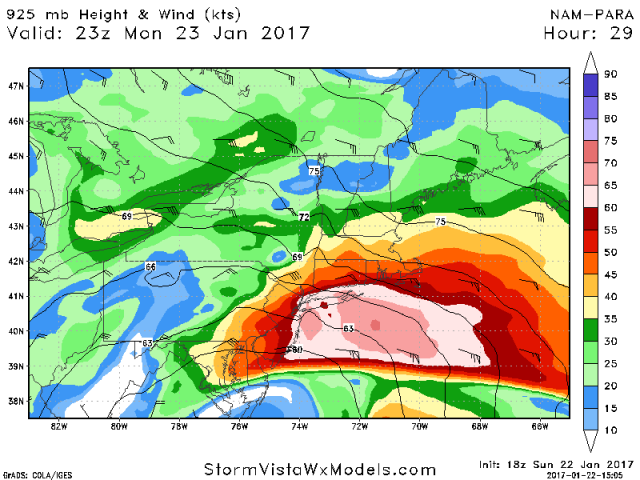
Destructive if that mixes down even losing 10% - 20% of its force.
SV maps are insane for these.
_________________
Mugs
AKA:King: Snow Weenie
Self Proclaimed
WINTER 2014-15 : 55.12" +.02 for 6 coatings (avg. 35")
WINTER 2015-16 Total - 29.8" (Avg 35")
WINTER 2016-17 : 39.5" so far
amugs- Advanced Forecaster - Mod
- Posts : 15093
Reputation : 213
Join date : 2013-01-07
Age : 54
Location : Hillsdale,NJ
Re: January 22nd-24th Nor'easter Observations & Discussions
![]() by amugs Sun Jan 22, 2017 3:42 pm
by amugs Sun Jan 22, 2017 3:42 pm
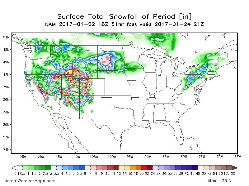
Most of this if not all is sleet so divide by 3.5

_________________
Mugs
AKA:King: Snow Weenie
Self Proclaimed
WINTER 2014-15 : 55.12" +.02 for 6 coatings (avg. 35")
WINTER 2015-16 Total - 29.8" (Avg 35")
WINTER 2016-17 : 39.5" so far
amugs- Advanced Forecaster - Mod
- Posts : 15093
Reputation : 213
Join date : 2013-01-07
Age : 54
Location : Hillsdale,NJ
Re: January 22nd-24th Nor'easter Observations & Discussions
![]() by Guest Sun Jan 22, 2017 3:43 pm
by Guest Sun Jan 22, 2017 3:43 pm
Guest- Guest
Re: January 22nd-24th Nor'easter Observations & Discussions
![]() by algae888 Sun Jan 22, 2017 3:44 pm
by algae888 Sun Jan 22, 2017 3:44 pm

algae888- Advanced Forecaster

- Posts : 5311
Reputation : 46
Join date : 2013-02-05
Age : 61
Location : mt. vernon, new york
Re: January 22nd-24th Nor'easter Observations & Discussions
![]() by skinsfan1177 Sun Jan 22, 2017 3:44 pm
by skinsfan1177 Sun Jan 22, 2017 3:44 pm
Last edited by skinsfan1177 on Sun Jan 22, 2017 3:52 pm; edited 1 time in total
skinsfan1177- Senior Enthusiast
- Posts : 4485
Reputation : 35
Join date : 2013-01-07
Age : 46
Location : Point Pleasant Boro
Re: January 22nd-24th Nor'easter Observations & Discussions
![]() by aiannone Sun Jan 22, 2017 3:44 pm
by aiannone Sun Jan 22, 2017 3:44 pm
...WINTER STORM WATCH IN EFFECT FROM MONDAY AFTERNOON THROUGH
TUESDAY AFTERNOON...
THE NATIONAL WEATHER SERVICE IN BINGHAMTON HAS ISSUED A WINTER
STORM WATCH...WHICH IS IN EFFECT FROM MONDAY AFTERNOON THROUGH
TUESDAY AFTERNOON.
* LOCATIONS...CENTRAL NEW YORK AND THE NORTHERN TIER OF
PENNSYLVANIA.
* HAZARD TYPES...HEAVY WET SNOW, SLEET, AND STRONG WINDS.
* ACCUMULATIONS...POTENTIAL FOR 6 TO 12 INCHES OF HEAVY, WET SNOW
AND SLEET WITH LOCALLY HIGHER AMOUNTS POSSIBLE. THE HEAVIEST
ACCUMULATIONS WILL BE OVER THE HIGHER TERRAIN WITH LOWER
AMOUNTS IN THE VALLEYS.
* TIMING...RAIN WILL DEVELOP BY EARLY MONDAY BUT BECOME MIXED WITH
SNOW AND SLEET FROM EAST TO WEST THROUGH THE DAY AS COLDER AIR
MOVES IN. A LITTLE FREEZING RAIN WILL ALSO BE POSSIBLE IN THE
TRANSITION BUT THIS DOES NOT LOOK TO BE THE MAIN THREAT. BY
EARLY MONDAY EVENING, MOST OF THE REGION WILL BE SEEING SNOW
MIXED WITH SLEET. SNOW AND SLEET, HEAVY AT TIMES, WILL CONTINUE
MONDAY NIGHT INTO EARLY TUESDAY BEFORE DIMINISHING WEST TO EAST
MIDDAY TUESDAY INTO THE AFTERNOON.
* IMPACTS...SNOW AND SLEET ACCUMULATIONS WILL MAKE MANY ROADS
TREACHEROUS AND TRAVEL VERY DANGEROUS BY LATE MONDAY AND
CONTINUING TUESDAY. THE STORM WILL BE ACCOMPANIED BY STRONG
WINDS WHICH WILL ADD TO THE IMPACT OF THE HEAVY WET SNOW AND
ICE...POTENTIALLY LEADING TO POWER OUTAGES.
* WINDS...NORTHEAST 15 TO 25 MPH WITH GUSTS OF 35 TO 45 MPH.
* TEMPERATURES...IN THE LOW TO MID 30S.
_________________
-Alex Iannone-
aiannone- Senior Enthusiast - Mod
- Posts : 4814
Reputation : 92
Join date : 2013-01-07
Location : Saint James, LI (Northwest Suffolk Co.)
Re: January 22nd-24th Nor'easter Observations & Discussions
![]() by billg315 Sun Jan 22, 2017 3:44 pm
by billg315 Sun Jan 22, 2017 3:44 pm
billg315- Advanced Forecaster - Mod
- Posts : 4469
Reputation : 185
Join date : 2015-01-24
Age : 50
Location : Flemington, NJ
Re: January 22nd-24th Nor'easter Observations & Discussions
![]() by rb924119 Sun Jan 22, 2017 3:45 pm
by rb924119 Sun Jan 22, 2017 3:45 pm
rb924119- Meteorologist

- Posts : 6890
Reputation : 194
Join date : 2013-02-06
Age : 32
Location : Greentown, Pa
Re: January 22nd-24th Nor'easter Observations & Discussions
![]() by Guest Sun Jan 22, 2017 3:46 pm
by Guest Sun Jan 22, 2017 3:46 pm
Guest- Guest
Re: January 22nd-24th Nor'easter Observations & Discussions
![]() by skinsfan1177 Sun Jan 22, 2017 3:53 pm
by skinsfan1177 Sun Jan 22, 2017 3:53 pm
skinsfan1177- Senior Enthusiast
- Posts : 4485
Reputation : 35
Join date : 2013-01-07
Age : 46
Location : Point Pleasant Boro
Re: January 22nd-24th Nor'easter Observations & Discussions
![]() by billg315 Sun Jan 22, 2017 3:54 pm
by billg315 Sun Jan 22, 2017 3:54 pm
billg315- Advanced Forecaster - Mod
- Posts : 4469
Reputation : 185
Join date : 2015-01-24
Age : 50
Location : Flemington, NJ
Re: January 22nd-24th Nor'easter Observations & Discussions
![]() by Guest Sun Jan 22, 2017 3:58 pm
by Guest Sun Jan 22, 2017 3:58 pm
Guest- Guest
Page 14 of 43 • 1 ... 8 ... 13, 14, 15 ... 28 ... 43 ![]()
|
|
|