
 Search
Long Range Thread 13.0
Page 8 of 40 •  1 ... 5 ... 7, 8, 9 ... 24 ... 40
 ![]()
Re: Long Range Thread 13.0
![]() by amugs Sun Jan 29, 2017 1:14 pm
by amugs Sun Jan 29, 2017 1:14 pm
EDIT : Armando just seeing your post (excellent write up) after I did this write up
.png)
amugs- Advanced Forecaster - Mod

- Posts : 15093
Join date : 2013-01-07
Re: Long Range Thread 13.0
![]() by amugs Sun Jan 29, 2017 2:45 pm
by amugs Sun Jan 29, 2017 2:45 pm
amugs- Advanced Forecaster - Mod
- Posts : 15093
Join date : 2013-01-07
Re: Long Range Thread 13.0
![]() by rb924119 Sun Jan 29, 2017 3:34 pm
by rb924119 Sun Jan 29, 2017 3:34 pm
rb924119- Meteorologist

- Posts : 6890
Reputation : 194
Join date : 2013-02-06
Age : 32
Location : Greentown, Pa
Re: Long Range Thread 13.0
![]() by amugs Sun Jan 29, 2017 3:56 pm
by amugs Sun Jan 29, 2017 3:56 pm
In Ray We Trust!!
_________________
Mugs
AKA:King: Snow Weenie
Self Proclaimed
WINTER 2014-15 : 55.12" +.02 for 6 coatings (avg. 35")
WINTER 2015-16 Total - 29.8" (Avg 35")
WINTER 2016-17 : 39.5" so far

amugs- Advanced Forecaster - Mod
- Posts : 15093
Reputation : 213
Join date : 2013-01-07
Age : 54
Location : Hillsdale,NJ
Re: Long Range Thread 13.0
![]() by amugs Sun Jan 29, 2017 4:37 pm
by amugs Sun Jan 29, 2017 4:37 pm

_________________
Mugs
AKA:King: Snow Weenie
Self Proclaimed
WINTER 2014-15 : 55.12" +.02 for 6 coatings (avg. 35")
WINTER 2015-16 Total - 29.8" (Avg 35")
WINTER 2016-17 : 39.5" so far
amugs- Advanced Forecaster - Mod
- Posts : 15093
Reputation : 213
Join date : 2013-01-07
Age : 54
Location : Hillsdale,NJ

jmanley32- Senior Enthusiast

- Posts : 20516
Reputation : 108
Join date : 2013-12-12
Age : 42
Location : Yonkers, NY
Re: Long Range Thread 13.0
![]() by amugs Sun Jan 29, 2017 6:42 pm
by amugs Sun Jan 29, 2017 6:42 pm
_________________
Mugs
AKA:King: Snow Weenie
Self Proclaimed
WINTER 2014-15 : 55.12" +.02 for 6 coatings (avg. 35")
WINTER 2015-16 Total - 29.8" (Avg 35")
WINTER 2016-17 : 39.5" so far
amugs- Advanced Forecaster - Mod
- Posts : 15093
Reputation : 213
Join date : 2013-01-07
Age : 54
Location : Hillsdale,NJ
Re: Long Range Thread 13.0
![]() by skinsfan1177 Sun Jan 29, 2017 6:54 pm
by skinsfan1177 Sun Jan 29, 2017 6:54 pm

skinsfan1177- Senior Enthusiast
- Posts : 4485
Reputation : 35
Join date : 2013-01-07
Age : 46
Location : Point Pleasant Boro
Re: Long Range Thread 13.0
![]() by billg315 Sun Jan 29, 2017 8:14 pm
by billg315 Sun Jan 29, 2017 8:14 pm

billg315- Advanced Forecaster - Mod
- Posts : 4466
Reputation : 185
Join date : 2015-01-24
Age : 50
Location : Flemington, NJ
Re: Long Range Thread 13.0
![]() by amugs Sun Jan 29, 2017 8:20 pm
by amugs Sun Jan 29, 2017 8:20 pm
_________________
Mugs
AKA:King: Snow Weenie
Self Proclaimed
WINTER 2014-15 : 55.12" +.02 for 6 coatings (avg. 35")
WINTER 2015-16 Total - 29.8" (Avg 35")
WINTER 2016-17 : 39.5" so far
amugs- Advanced Forecaster - Mod
- Posts : 15093
Reputation : 213
Join date : 2013-01-07
Age : 54
Location : Hillsdale,NJ
Re: Long Range Thread 13.0
![]() by Isotherm Sun Jan 29, 2017 8:21 pm
by Isotherm Sun Jan 29, 2017 8:21 pm
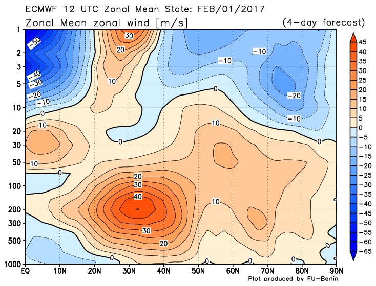
I am not yet at the inflection point of pulling the trigger on this evolution definitively, in terms of stratospheric progression and subsequent tropospheric response, but my confidence on the probability of its occurrence is increasing. The resultant impacts could be our most negative NAO/AO period of the winter, circa 2/15-3/15. The NAO and AO are neutral to positive for the first half of Feb.
As far as the synoptic set-ups for snow prior to 2/15, 2/6 still looks like a time frame to monitor for a moderate event. I am not as interested in 2/6 as I was in prior days, but it still holds potential certainly.
Regardless, an intriguing period of tracking from a meteorological, academic perspective at the very least. Changes are clearly afoot with the BDC and O3 transport, although the WQBO will attempt to destructively interfere, its modulation will be lessened by the double-jab wave flux. I expect stratospheric charts to become more impressive again in the D10+.
Isotherm- Advanced Forecaster

- Posts : 231
Reputation : 4
Join date : 2014-09-01
Age : 33
Location : Monmouth County, NJ -

Re: Long Range Thread 13.0
![]() by Isotherm Sun Jan 29, 2017 10:34 pm
by Isotherm Sun Jan 29, 2017 10:34 pm
Isotherm- Advanced Forecaster
- Posts : 231
Reputation : 4
Join date : 2014-09-01
Age : 33
Location : Monmouth County, NJ -
Re: Long Range Thread 13.0
![]() by Frank_Wx Sun Jan 29, 2017 11:25 pm
by Frank_Wx Sun Jan 29, 2017 11:25 pm


_________________
_______________________________________________________________________________________________________
CLICK HERE to view NJ Strong Snowstorm Classifications

Frank_Wx- Godzilla Seeker

- Posts : 21305
Reputation : 328
Join date : 2013-01-05
Age : 31
Location : Jersey City, NJ -
Re: Long Range Thread 13.0
![]() by Frank_Wx Sun Jan 29, 2017 11:40 pm
by Frank_Wx Sun Jan 29, 2017 11:40 pm
_________________
_______________________________________________________________________________________________________
CLICK HERE to view NJ Strong Snowstorm Classifications
Frank_Wx- Godzilla Seeker
- Posts : 21305
Reputation : 328
Join date : 2013-01-05
Age : 31
Location : Jersey City, NJ -
Re: Long Range Thread 13.0
![]() by Armando Salvadore Sun Jan 29, 2017 11:57 pm
by Armando Salvadore Sun Jan 29, 2017 11:57 pm

Armando Salvadore- Advanced Forecaster
- Posts : 171
Reputation : 0
Join date : 2016-12-23
Location : Springfield, NJ
Re: Long Range Thread 13.0
![]() by amugs Mon Jan 30, 2017 8:09 am
by amugs Mon Jan 30, 2017 8:09 am


then the 8-9th - JIM WITT made this call back in August and again the 22-24th time frame again.
_________________
Mugs
AKA:King: Snow Weenie
Self Proclaimed
WINTER 2014-15 : 55.12" +.02 for 6 coatings (avg. 35")
WINTER 2015-16 Total - 29.8" (Avg 35")
WINTER 2016-17 : 39.5" so far
amugs- Advanced Forecaster - Mod
- Posts : 15093
Reputation : 213
Join date : 2013-01-07
Age : 54
Location : Hillsdale,NJ
Re: Long Range Thread 13.0
![]() by track17 Mon Jan 30, 2017 9:20 am
by track17 Mon Jan 30, 2017 9:20 am
track17- Posts : 454
Reputation : 4
Join date : 2016-01-09
Re: Long Range Thread 13.0
![]() by rb924119 Mon Jan 30, 2017 9:28 am
by rb924119 Mon Jan 30, 2017 9:28 am
track17 wrote:skins looks like our winter is over at the jersey shore every threat has us at rain. Oh well good luck to everyone else
WOAH WOAH WOAH WOAHHHHH Blasphemy of the highest order!! Cp where's that Monty Python clip??? Nah, in all seriousness buddy, do NOT sweat the details at this point. All any of us should care about right now is that the signal is still there. Don't forget the last storm we had that was largely sleet where 24 hours before H5 was progged to track through Pittsburgh, Pa and ended up swinging 500 miles right to exit off the Delmarva. If changes like that are possible, a 50-mile shift of the thermal gradient should pretty much be expected, whether for good or bad. Patience, my friend, patience.
rb924119- Meteorologist
- Posts : 6890
Reputation : 194
Join date : 2013-02-06
Age : 32
Location : Greentown, Pa
Re: Long Range Thread 13.0
![]() by skinsfan1177 Mon Jan 30, 2017 10:16 am
by skinsfan1177 Mon Jan 30, 2017 10:16 am
rb924119 wrote:track17 wrote:skins looks like our winter is over at the jersey shore every threat has us at rain. Oh well good luck to everyone else
WOAH WOAH WOAH WOAHHHHH Blasphemy of the highest order!! Cp where's that Monty Python clip??? Nah, in all seriousness buddy, do NOT sweat the details at this point. All any of us should care about right now is that the signal is still there. Don't forget the last storm we had that was largely sleet where 24 hours before H5 was progged to track through Pittsburgh, Pa and ended up swinging 500 miles right to exit off the Delmarva. If changes like that are possible, a 50-mile shift of the thermal gradient should pretty much be expected, whether for good or bad. Patience, my friend, patience.
Great post I like the spot we are in don't want jackpot spot right now lots of time. Patience
skinsfan1177- Senior Enthusiast
- Posts : 4485
Reputation : 35
Join date : 2013-01-07
Age : 46
Location : Point Pleasant Boro
Re: Long Range Thread 13.0
![]() by dsix85 Mon Jan 30, 2017 11:20 am
by dsix85 Mon Jan 30, 2017 11:20 am
dsix85- Pro Enthusiast

- Posts : 349
Reputation : 8
Join date : 2014-01-01
Location : New York
Re: Long Range Thread 13.0
![]() by jake732 Mon Jan 30, 2017 11:27 am
by jake732 Mon Jan 30, 2017 11:27 am

jake732- Pro Enthusiast
- Posts : 449
Reputation : 0
Join date : 2016-01-03
Location : lakewood, nj -
Re: Long Range Thread 13.0
![]() by sroc4 Mon Jan 30, 2017 11:31 am
by sroc4 Mon Jan 30, 2017 11:31 am

_________________
"In weather and in life, there's no winning and losing; there's only winning and learning."
WINTER 2012/2013 TOTALS 43.65"WINTER 2017/2018 TOTALS 62.85" WINTER 2022/2023 TOTALS 4.9"
WINTER 2013/2014 TOTALS 64.85"WINTER 2018/2019 TOTALS 14.25" WINTER 2023/2024 TOTALS 13.1"
WINTER 2014/2015 TOTALS 71.20"WINTER 2019/2020 TOTALS 6.35"
WINTER 2015/2016 TOTALS 35.00"WINTER 2020/2021 TOTALS 37.75"
WINTER 2016/2017 TOTALS 42.25"WINTER 2021/2022 TOTALS 31.65"

sroc4- Admin
- Posts : 8331
Reputation : 301
Join date : 2013-01-07
Location : Wading River, LI
Re: Long Range Thread 13.0
![]() by Frank_Wx Mon Jan 30, 2017 11:33 am
by Frank_Wx Mon Jan 30, 2017 11:33 am
dsix85 wrote:I'm sure I missed it, but can someone explain what a "Mothrazilla" is?
Click the link in my signature
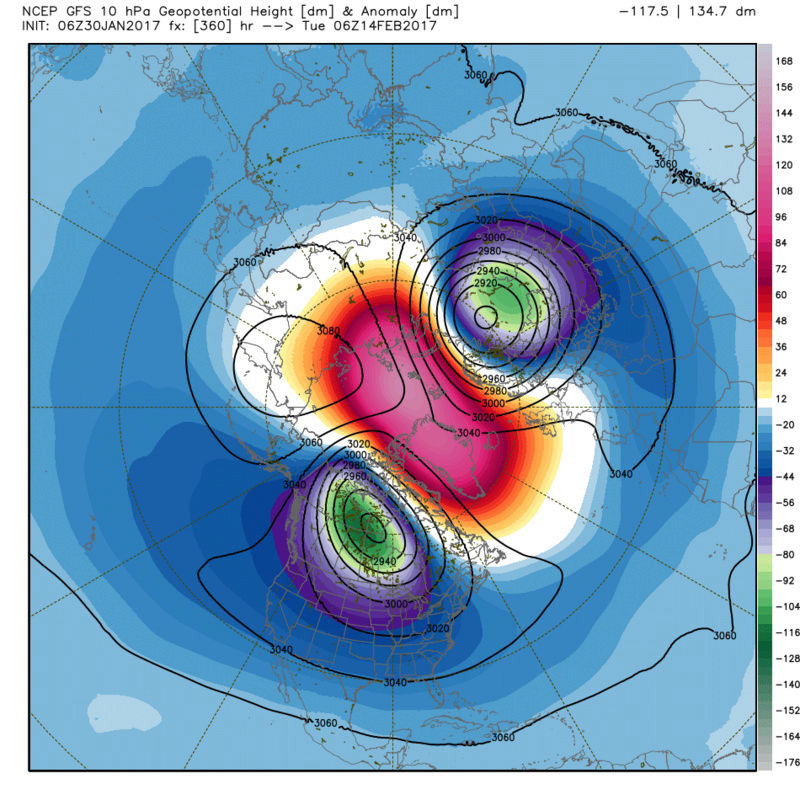
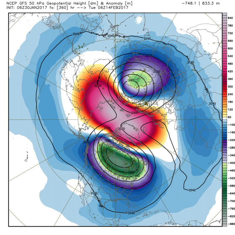
sroc4 wrote:This is exciting stuff should this occur verbatim. Dont look now but GFS has a full on SSWE. Now it is the LR so take with a grain of salt, but our Strat guru Isotherm, has bee getting more and more excited about this possibility. The process begins about day 10 but here are the images for day 15 showing a top to bottom split to the Strat PV which would lead to a high probability of an amazing final act for winter ending Feb and early March. I look forward to updates from Isotherm over the next 1-2weeks regarding the strat.

_________________
_______________________________________________________________________________________________________
CLICK HERE to view NJ Strong Snowstorm Classifications
Frank_Wx- Godzilla Seeker
- Posts : 21305
Reputation : 328
Join date : 2013-01-05
Age : 31
Location : Jersey City, NJ -
Re: Long Range Thread 13.0
![]() by Frank_Wx Mon Jan 30, 2017 11:35 am
by Frank_Wx Mon Jan 30, 2017 11:35 am
_________________
_______________________________________________________________________________________________________
CLICK HERE to view NJ Strong Snowstorm Classifications
Frank_Wx- Godzilla Seeker
- Posts : 21305
Reputation : 328
Join date : 2013-01-05
Age : 31
Location : Jersey City, NJ -
Re: Long Range Thread 13.0
![]() by jmanley32 Mon Jan 30, 2017 11:39 am
by jmanley32 Mon Jan 30, 2017 11:39 am
Stop playing! LOL, I just got myself to accept only seeing a mothra and no godzilla no you got me hoping for a roid LOL, this winter is topsy turvy. Just as long as weekend of Feb 17th-119th is clear for travel I am a go for a mega storm.Frank_Wx wrote:The storm threat between the 8th-10th has Roidzilla potential.
jmanley32- Senior Enthusiast
- Posts : 20516
Reputation : 108
Join date : 2013-12-12
Age : 42
Location : Yonkers, NY
Re: Long Range Thread 13.0
![]() by Frank_Wx Mon Jan 30, 2017 11:40 am
by Frank_Wx Mon Jan 30, 2017 11:40 am
jmanley32 wrote:Stop playing! LOL, I just got myself to accept only seeing a mothra and no godzilla no you got me hoping for a roid LOL, this winter is topsy turvy. Just as long as weekend of Feb 17th-119th is clear for travel I am a go for a mega storm.Frank_Wx wrote:The storm threat between the 8th-10th has Roidzilla potential.
Don't confuse the events. February 5th-6th is the Mothrazilla/Godzilla one. 8th-10th is a different system (check homepage)
_________________
_______________________________________________________________________________________________________
CLICK HERE to view NJ Strong Snowstorm Classifications
Frank_Wx- Godzilla Seeker
- Posts : 21305
Reputation : 328
Join date : 2013-01-05
Age : 31
Location : Jersey City, NJ -
Re: Long Range Thread 13.0
![]() by Frank_Wx Mon Jan 30, 2017 11:41 am
by Frank_Wx Mon Jan 30, 2017 11:41 am

_________________
_______________________________________________________________________________________________________
CLICK HERE to view NJ Strong Snowstorm Classifications
Frank_Wx- Godzilla Seeker
- Posts : 21305
Reputation : 328
Join date : 2013-01-05
Age : 31
Location : Jersey City, NJ -
Page 8 of 40 • 1 ... 5 ... 7, 8, 9 ... 24 ... 40 ![]()
|
|
|