
 Search
Long Range Thread 13.0
Page 26 of 40 •  1 ... 14 ... 25, 26, 27 ... 33 ... 40
 ![]()
Re: Long Range Thread 13.0
![]() by Radz Thu Feb 16, 2017 8:20 pm
by Radz Thu Feb 16, 2017 8:20 pm
Snow88 wrote:Wow 18z GFS is active
MJO is still traveling through 8 and possibly heading into 1 which is a cold and stormy phases for the coast. The soi is also crashing . It will be interesting to see if we can get into a stormy pattern later this month into early march.
Was just thinking the same thing after looking at it- hopeful to say the least
Radz- Pro Enthusiast

- Posts : 1028
Join date : 2013-01-12
Re: Long Range Thread 13.0
![]() by amugs Fri Feb 17, 2017 8:18 am
by amugs Fri Feb 17, 2017 8:18 am

This is what Scott was talking about and MJONON EURO saying we go into phase 1 and then 2. If so it promotes an trough on the e at cost with stormy conditions.
The SOI though is a MASSIVE drop and it will have a MAJOR effect on us here about 8 days from now. HP all over the Austin N coast through Tahiti.
Lastly El nino is forecasted to come back by Summer. Hoping ithis a weak to moderate Modoki one!
Last edited by amugs on Fri Feb 17, 2017 8:55 am; edited 1 time in total
amugs- Advanced Forecaster - Mod

- Posts : 15093
Join date : 2013-01-07
Re: Long Range Thread 13.0
![]() by Guest Fri Feb 17, 2017 8:25 am
by Guest Fri Feb 17, 2017 8:25 am
https://www.longpaddock.qld.gov.au/seasonalclimateoutlook/southernoscillationindex/30daysoivalues/
Guest- Guest
Re: Long Range Thread 13.0
![]() by amugs Fri Feb 17, 2017 11:38 am
by amugs Fri Feb 17, 2017 11:38 am

_________________
Mugs
AKA:King: Snow Weenie
Self Proclaimed
WINTER 2014-15 : 55.12" +.02 for 6 coatings (avg. 35")
WINTER 2015-16 Total - 29.8" (Avg 35")
WINTER 2016-17 : 39.5" so far

amugs- Advanced Forecaster - Mod
- Posts : 15093
Reputation : 213
Join date : 2013-01-07
Age : 54
Location : Hillsdale,NJ
Re: Long Range Thread 13.0
![]() by Math23x7 Fri Feb 17, 2017 2:09 pm
by Math23x7 Fri Feb 17, 2017 2:09 pm
Math23x7- Wx Statistician Guru

- Posts : 2379
Reputation : 68
Join date : 2013-01-08
Re: Long Range Thread 13.0
![]() by Snow88 Fri Feb 17, 2017 2:34 pm
by Snow88 Fri Feb 17, 2017 2:34 pm
Soi is crashing along with a favorable MJO moving forward
Last week of February into March looks very favorable

Snow88- Senior Enthusiast

- Posts : 2193
Reputation : 4
Join date : 2013-01-09
Age : 35
Location : Brooklyn, NY
Re: Long Range Thread 13.0
![]() by sroc4 Fri Feb 17, 2017 2:40 pm
by sroc4 Fri Feb 17, 2017 2:40 pm
Snow88 wrote:I doubt winter is over
Soi is crashing along with a favorable MJO moving forward
Last week of February into March looks very favorable
I agree with you Tony. Unfort Mikey has turned to the dark side and seemingly enjoys posting about the warm weather.
_________________
"In weather and in life, there's no winning and losing; there's only winning and learning."
WINTER 2012/2013 TOTALS 43.65"WINTER 2017/2018 TOTALS 62.85" WINTER 2022/2023 TOTALS 4.9"
WINTER 2013/2014 TOTALS 64.85"WINTER 2018/2019 TOTALS 14.25" WINTER 2023/2024 TOTALS 13.1"
WINTER 2014/2015 TOTALS 71.20"WINTER 2019/2020 TOTALS 6.35"
WINTER 2015/2016 TOTALS 35.00"WINTER 2020/2021 TOTALS 37.75"
WINTER 2016/2017 TOTALS 42.25"WINTER 2021/2022 TOTALS 31.65"

sroc4- Admin

- Posts : 8331
Reputation : 301
Join date : 2013-01-07
Location : Wading River, LI
Re: Long Range Thread 13.0
![]() by CPcantmeasuresnow Fri Feb 17, 2017 2:44 pm
by CPcantmeasuresnow Fri Feb 17, 2017 2:44 pm
sroc4 wrote:Snow88 wrote:I doubt winter is over
Soi is crashing along with a favorable MJO moving forward
Last week of February into March looks very favorable
I agree with you Tony. Unfort Mikey has turned to the dark side and seemingly enjoys posting about the warm weather.
Mikey's been accused of Torch Mongering in the past, let's hope this isn't a repeat.

CPcantmeasuresnow- Wx Statistician Guru
- Posts : 7274
Reputation : 230
Join date : 2013-01-07
Age : 103
Location : Eastern Orange County, NY
Re: Long Range Thread 13.0
![]() by Math23x7 Fri Feb 17, 2017 3:13 pm
by Math23x7 Fri Feb 17, 2017 3:13 pm
CPcantmeasuresnow wrote:sroc4 wrote:Snow88 wrote:I doubt winter is over
Soi is crashing along with a favorable MJO moving forward
Last week of February into March looks very favorable
I agree with you Tony. Unfort Mikey has turned to the dark side and seemingly enjoys posting about the warm weather.
Mikey's been accused of Torch Mongering in the past, let's hope this isn't a repeat.
There is a meteorologist I met a few years ago named Dave Tolleris (DT) from wxrisk.com. He may be insulting, but he is the kind of guy that understands what the pattern holds, whether you like it or not. His latest video from earlier this week indicates that he does not see any snow threats in the East until at least mid-March. And that is simply because the QBO/EPO has been so unfavorable for us.
He starts talking about the horrific long range at around 6:54 in the video:
Math23x7- Wx Statistician Guru
- Posts : 2379
Reputation : 68
Join date : 2013-01-08
Re: Long Range Thread 13.0
![]() by sroc4 Fri Feb 17, 2017 3:32 pm
by sroc4 Fri Feb 17, 2017 3:32 pm
Math23x7 wrote:CPcantmeasuresnow wrote:sroc4 wrote:Snow88 wrote:I doubt winter is over
Soi is crashing along with a favorable MJO moving forward
Last week of February into March looks very favorable
I agree with you Tony. Unfort Mikey has turned to the dark side and seemingly enjoys posting about the warm weather.
Mikey's been accused of Torch Mongering in the past, let's hope this isn't a repeat.
There is a meteorologist I met a few years ago named Dave Tolleris (DT) from wxrisk.com. He may be insulting, but he is the kind of guy that understands what the pattern holds, whether you like it or not. His latest video from earlier this week indicates that he does not see any snow threats in the East until at least mid-March. And that is simply because the QBO/EPO has been so unfavorable for us.
He starts talking about the horrific long range at around 6:54 in the video:
I know exactly who he is Mike, and to be quite honest his accuracy is no different than anyone else. The collaborative efforts of our board is more accurate than he is; the only difference is that he is an absolute A-hole to anyone who challenges his ideas. I have ZERO respect for a man who treats people the way he does and he doesn't deserve any more of my attention.
As far as the pattern is concerned the idea that no snow until mid March may very well be right, but to simply poo poo the anomalous changes seen in the trop Pac now and over the next 7-10Days is stupid. As we approach the end of next week we will see if his thoughts have changed at all. I will actually watch his video later and see if I agree with his ideas.
_________________
"In weather and in life, there's no winning and losing; there's only winning and learning."
WINTER 2012/2013 TOTALS 43.65"WINTER 2017/2018 TOTALS 62.85" WINTER 2022/2023 TOTALS 4.9"
WINTER 2013/2014 TOTALS 64.85"WINTER 2018/2019 TOTALS 14.25" WINTER 2023/2024 TOTALS 13.1"
WINTER 2014/2015 TOTALS 71.20"WINTER 2019/2020 TOTALS 6.35"
WINTER 2015/2016 TOTALS 35.00"WINTER 2020/2021 TOTALS 37.75"
WINTER 2016/2017 TOTALS 42.25"WINTER 2021/2022 TOTALS 31.65"
sroc4- Admin
- Posts : 8331
Reputation : 301
Join date : 2013-01-07
Location : Wading River, LI
Re: Long Range Thread 13.0
![]() by amugs Fri Feb 17, 2017 3:55 pm
by amugs Fri Feb 17, 2017 3:55 pm
MJO trop forcing that correlates to this Rossby wave going to drive it from 8 through 1 into 2 if it holds of course but can it make it to 3?
Here is the aussies


March Phases
Lastly as Isotherm has pointed out we have our last Srat Warming event.
All these should add up to something for us and I take it one week at that at a time with one eye on the LR for some candy!
You have been one to call torch a few times this winter - heck we have a warm base state no doubt but if you like that in winter then I suggest you move so you can enjoy such weather year round in Ga or NC my friend.
AGW? CC for me due to various factors - more terrestrial and our own planet evolution process but not the man made kind,sorry.
_________________
Mugs
AKA:King: Snow Weenie
Self Proclaimed
WINTER 2014-15 : 55.12" +.02 for 6 coatings (avg. 35")
WINTER 2015-16 Total - 29.8" (Avg 35")
WINTER 2016-17 : 39.5" so far
amugs- Advanced Forecaster - Mod
- Posts : 15093
Reputation : 213
Join date : 2013-01-07
Age : 54
Location : Hillsdale,NJ
Re: Long Range Thread 13.0
![]() by Frank_Wx Sat Feb 18, 2017 8:56 am
by Frank_Wx Sat Feb 18, 2017 8:56 am

For some its been an ok winter, reaching their seasonal snowfall totals, but for others its been quite poor. Above normal temperatures and well below seasonal snowfall. If the GEFS are correct about the LR depiction, then we could have possibly seen our last snowfall.
_________________
_______________________________________________________________________________________________________
CLICK HERE to view NJ Strong Snowstorm Classifications

Frank_Wx- Godzilla Seeker
- Posts : 21305
Reputation : 328
Join date : 2013-01-05
Age : 31
Location : Jersey City, NJ -

Re: Long Range Thread 13.0
![]() by Armando Salvadore Sat Feb 18, 2017 9:04 am
by Armando Salvadore Sat Feb 18, 2017 9:04 am
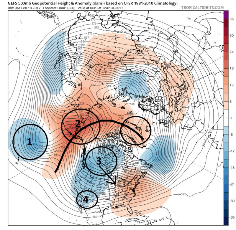
Frank_Wx wrote:The LR does not look as favorable as it once did for a return of wintry weather very end of this month. I do think there is natural waffling going on, and we should see a mean trough back over the east at some point, but the GEFS keep the mean trough over the western U.S.
For some its been an ok winter, reaching their seasonal snowfall totals, but for others its been quite poor. Above normal temperatures and well below seasonal snowfall. If the GEFS are correct about the LR depiction, then we could have possibly seen our last snowfall.
Yep, EPS and GEFS have been showing that canonical NINA forcing over the past few days. Now, i probably can buy them correcting the trough more east and we're seeing quite the SOI drop and an ECMWF MJO P2 amplitude would be the catalyst. Still, we see the wave break and a short -EPO period. That same right retrogrades west back into the Aleutians and it's rinse, wash, and repeat all over. So, we may have a very short period, but really not enthused as i originally was. We'll see, but i'm looking forward to Spring! If winter were to end today, i'd finish the season with around 21" of snow (below avg) and above average temps. To be able to get over the 20" mark in a winter like this, i won't complain!

Armando Salvadore- Advanced Forecaster

- Posts : 171
Reputation : 0
Join date : 2016-12-23
Location : Springfield, NJ
Re: Long Range Thread 13.0
![]() by Frank_Wx Sat Feb 18, 2017 9:07 am
by Frank_Wx Sat Feb 18, 2017 9:07 am
_________________
_______________________________________________________________________________________________________
CLICK HERE to view NJ Strong Snowstorm Classifications
Frank_Wx- Godzilla Seeker
- Posts : 21305
Reputation : 328
Join date : 2013-01-05
Age : 31
Location : Jersey City, NJ -
Re: Long Range Thread 13.0
![]() by sroc4 Sat Feb 18, 2017 9:23 am
by sroc4 Sat Feb 18, 2017 9:23 am
Math23x7 wrote:CPcantmeasuresnow wrote:sroc4 wrote:Snow88 wrote:I doubt winter is over
Soi is crashing along with a favorable MJO moving forward
Last week of February into March looks very favorable
I agree with you Tony. Unfort Mikey has turned to the dark side and seemingly enjoys posting about the warm weather.
Mikey's been accused of Torch Mongering in the past, let's hope this isn't a repeat.
There is a meteorologist I met a few years ago named Dave Tolleris (DT) from wxrisk.com. He may be insulting, but he is the kind of guy that understands what the pattern holds, whether you like it or not. His latest video from earlier this week indicates that he does not see any snow threats in the East until at least mid-March. And that is simply because the QBO/EPO has been so unfavorable for us.
He starts talking about the horrific long range at around 6:54 in the video:
Ok Mikey I told you I would watch his video and see if I agree. Let me say this. In my line of work I am taught to evaluate the content of what I read or hear being stated and using my own knowledge of the subject make a decision if any or all of it makes sense. In addition I am also taught to look specifically for flaws in the study or discussion, that may leave reasonable doubt into how the conclusions were achieved even if the conclusions end up correct. Ill give you an example of what I mean:
In veterinary medicine a common question I get is when is the right time to spay or neuter my pet? In years passed I would have said between 6-8months. However, there was a prospective study that came out of Europe that looked at pets fixed before 1yr and ones that were fixed later in life or not at all. They specifically looked at the frequency of certain cancers that developed in animals fixed early, vs late vs not at all. The study concluded that there was a statistically significant increase in the number of pets who got this cancer fixed early vs a lower freq of incidence in the ones fixed late or not at all. If you took this study at face value you wouldn't think twice about waiting to fix your dog until much later or not at all.
Now here is where you need to spot the flaws. Being a prospective study all they did was simply look for this specific cancer and whether or not the pets were spayed or neutered. They did not take into consideration any other variables. Ie: breed predisposition, environmental/life style factors, diets etc.
The point here is that there clearly are other factors other than when a dog is spayed or neutered that need to be examined here. So lets bring this back to DT's discussion.
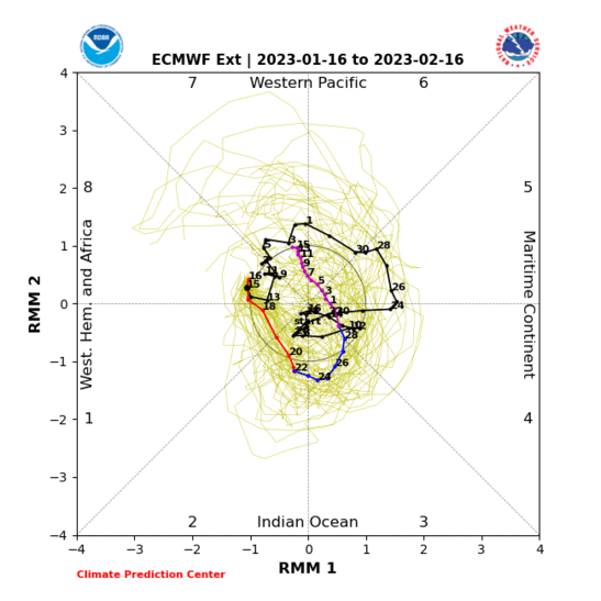
Lets begin with his discussion about the MJO and phase 8 being a phase for significant winter storms. He does a nice job giving examples of years past where a significant storm developed when the MJO was in or around phase 8. I absolutely agree with this assesment about phase 8. That's all fine and dandy, but do you think that's the only phase that has a statistically higher likelihood for significant EC storms and or cold? NO of course not. Lets now discuss how DT apparently is taking the LR MJO forecast verbatim without recognizing that LR forecasts can evolve. He shows the EMON forecasts that was valid as of Feb 10th. He points out how the LR MJO forecast will be headed into the COD and possibly come back out by mid-late march into phase 7-8 once again. Well lets look at the current MJO forecast and see if that idea has changed. We will look at the EMON once again since that's what he used. As you can plainly see the MJO clearly no longer looks like it wants to go into the COD anymore, but instead propagate through phases 1-2-3 before then MAYBE headed towards neutral/COD. I will also point out it does so with significant amplitude through phases 1-2-3.
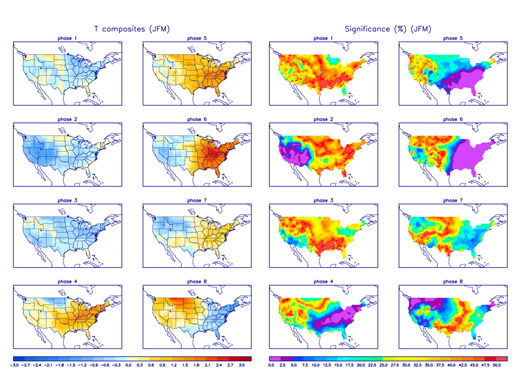
Here is the temperature composites for the MJO phases for FebMarApril. Phase1 is some what neutral for the NE, but phases 2 and 3 are clearly COLD phases. This tells me that we are likely to see a cold air invasion into the central CONUS that bleeds east as the MJO conts its propagation.
Now lets revisit your quote Mikey from above. "He starts talking about the horrific long range at around 6:54 in the video" DT actually does a really nice job highlighting the 10day and why the majority of the rest of Feb is going to be warm. He shows the Pac jet extension into the West Coast and describes how the warm Pac air will flood the CONUS etc, leading up to about the Feb22nd-25th time frame very nicely. I would like to point out; however, that myself, Frank, Isotherm, Armando, and a bunch of others have just as nicely have discussed this exact same thing. No one is denying the anomalous warmth that will be around, but DT never makes any mention at all of the last few days of Feb into the mid March time frame as being a time to watch for an EC storm. Why?
Well The brief 2-4second statement he says at around 7:45 where he says he doesn't see any chance for an EC snow threat until mid-late March for which you seem to buy into Mikey is predicated on the idea that he apparently thinks that only phase 8 of the MJO is capable of producing. Since he buys the FEB 10th thirty day forecast of the EMON as gospel and not going to change headed into the COD and maybe coming back out in 8 by end of March and all the other phases don't seem to matter. Now do we really think this is a smart approach? Again even if the result is correct, no significant EC storms, the reasoning is highly flawed.
So given what I see involving the MJO, SOI, strat etc., there will be at least 1 probably 2, maybe 3 chances at a Significant EC snow threat between Feb 28th and March 10th. Mikey I would like for you to post DT's thoughts on what to expect going forward in a week to 10days from now. Remember for a significant EC storm we need to have a cold air source. The MJO will likely lead to the wave break in the Pac that will change the structure of the Pac jet such that if the timing is right in the period I outlined and a system develops along the coast it will have a cold air source to bring in the cold air needed. For me however the one area that can cause my theory to fall short is the persistent energy that likes to hold back in the SW CONUS during these apparent pattern shifts toward what should be a colder snowier pattern. It has happened time and time again this winter. Again we will see where we stand in about a week. With the changes occurring in the Trop Pac modeling will likely not lock onto the big picture with consistency for some time yet.
_________________
"In weather and in life, there's no winning and losing; there's only winning and learning."
WINTER 2012/2013 TOTALS 43.65"WINTER 2017/2018 TOTALS 62.85" WINTER 2022/2023 TOTALS 4.9"
WINTER 2013/2014 TOTALS 64.85"WINTER 2018/2019 TOTALS 14.25" WINTER 2023/2024 TOTALS 13.1"
WINTER 2014/2015 TOTALS 71.20"WINTER 2019/2020 TOTALS 6.35"
WINTER 2015/2016 TOTALS 35.00"WINTER 2020/2021 TOTALS 37.75"
WINTER 2016/2017 TOTALS 42.25"WINTER 2021/2022 TOTALS 31.65"
sroc4- Admin
- Posts : 8331
Reputation : 301
Join date : 2013-01-07
Location : Wading River, LI
Re: Long Range Thread 13.0
![]() by sroc4 Sat Feb 18, 2017 9:32 am
by sroc4 Sat Feb 18, 2017 9:32 am
_________________
"In weather and in life, there's no winning and losing; there's only winning and learning."
WINTER 2012/2013 TOTALS 43.65"WINTER 2017/2018 TOTALS 62.85" WINTER 2022/2023 TOTALS 4.9"
WINTER 2013/2014 TOTALS 64.85"WINTER 2018/2019 TOTALS 14.25" WINTER 2023/2024 TOTALS 13.1"
WINTER 2014/2015 TOTALS 71.20"WINTER 2019/2020 TOTALS 6.35"
WINTER 2015/2016 TOTALS 35.00"WINTER 2020/2021 TOTALS 37.75"
WINTER 2016/2017 TOTALS 42.25"WINTER 2021/2022 TOTALS 31.65"
sroc4- Admin
- Posts : 8331
Reputation : 301
Join date : 2013-01-07
Location : Wading River, LI
Re: Long Range Thread 13.0
![]() by rb924119 Sat Feb 18, 2017 9:42 am
by rb924119 Sat Feb 18, 2017 9:42 am
rb924119- Meteorologist

- Posts : 6890
Reputation : 194
Join date : 2013-02-06
Age : 32
Location : Greentown, Pa
Re: Long Range Thread 13.0
![]() by Guest Sat Feb 18, 2017 10:32 am
by Guest Sat Feb 18, 2017 10:32 am
Guest- Guest
Re: Long Range Thread 13.0
![]() by skinsfan1177 Sat Feb 18, 2017 11:09 am
by skinsfan1177 Sat Feb 18, 2017 11:09 am

skinsfan1177- Senior Enthusiast
- Posts : 4485
Reputation : 35
Join date : 2013-01-07
Age : 46
Location : Point Pleasant Boro
Re: Long Range Thread 13.0
![]() by weatherwatchermom Sat Feb 18, 2017 11:35 am
by weatherwatchermom Sat Feb 18, 2017 11:35 am

weatherwatchermom- Senior Enthusiast
- Posts : 3747
Reputation : 77
Join date : 2014-11-25
Age : 60
Location : Hazlet Township, NJ
Re: Long Range Thread 13.0
![]() by sroc4 Sat Feb 18, 2017 12:00 pm
by sroc4 Sat Feb 18, 2017 12:00 pm
_________________
"In weather and in life, there's no winning and losing; there's only winning and learning."
WINTER 2012/2013 TOTALS 43.65"WINTER 2017/2018 TOTALS 62.85" WINTER 2022/2023 TOTALS 4.9"
WINTER 2013/2014 TOTALS 64.85"WINTER 2018/2019 TOTALS 14.25" WINTER 2023/2024 TOTALS 13.1"
WINTER 2014/2015 TOTALS 71.20"WINTER 2019/2020 TOTALS 6.35"
WINTER 2015/2016 TOTALS 35.00"WINTER 2020/2021 TOTALS 37.75"
WINTER 2016/2017 TOTALS 42.25"WINTER 2021/2022 TOTALS 31.65"
sroc4- Admin
- Posts : 8331
Reputation : 301
Join date : 2013-01-07
Location : Wading River, LI
Re: Long Range Thread 13.0
![]() by Isotherm Sat Feb 18, 2017 2:37 pm
by Isotherm Sat Feb 18, 2017 2:37 pm
Isotherm- Advanced Forecaster
- Posts : 231
Reputation : 4
Join date : 2014-09-01
Age : 33
Location : Monmouth County, NJ -
Re: Long Range Thread 13.0
![]() by Isotherm Sat Feb 18, 2017 2:40 pm
by Isotherm Sat Feb 18, 2017 2:40 pm
Isotherm- Advanced Forecaster
- Posts : 231
Reputation : 4
Join date : 2014-09-01
Age : 33
Location : Monmouth County, NJ -
Re: Long Range Thread 13.0
![]() by Guest Sat Feb 18, 2017 2:43 pm
by Guest Sat Feb 18, 2017 2:43 pm
Guest- Guest
Re: Long Range Thread 13.0
![]() by algae888 Sat Feb 18, 2017 3:25 pm
by algae888 Sat Feb 18, 2017 3:25 pm
Iso thanks for the Ray of Hope as I for one have been one of the most hopeful on here this winter. Looking at the guidance the last several days the ensembles have shifted the truogh to the West and have the persistent Ridge in the east. With the mjo Amplified and in favorable phases plus your comments on the Strat I was wondering if there are other drivers that are overcoming the drivers I just mentioned or as you put it guidance is having a tough time with the transition? You would think we would start to see changes post day 7 at this time but they seem to be trending worse.Isotherm wrote:I dont usually like to use this phraseology, but I think some (not here) might be falling into the same traps of the past few months, namely, priotizing model guidance over pattern indicators, when it should be the reverse. LR will seem impossible if one sways with the tides of daily model variance. Model performance has beeb abysmal post D7 this winter. Usually model data will correct to solutions congruous with exogenous forcing mechanisms. If they don't, there exists a logical flaw in the analysis which must be remedied. But I remain confident we are not done.

algae888- Advanced Forecaster
- Posts : 5311
Reputation : 46
Join date : 2013-02-05
Age : 61
Location : mt. vernon, new york
Re: Long Range Thread 13.0
![]() by sroc4 Sat Feb 18, 2017 4:23 pm
by sroc4 Sat Feb 18, 2017 4:23 pm
algae888 wrote:Iso thanks for the Ray of Hope as I for one have been one of the most hopeful on here this winter. Looking at the guidance the last several days the ensembles have shifted the truogh to the West and have the persistent Ridge in the east. With the mjo Amplified and in favorable phases plus your comments on the Strat I was wondering if there are other drivers that are overcoming the drivers I just mentioned or as you put it guidance is having a tough time with the transition? You would think we would start to see changes post day 7 at this time but they seem to be trending worse.Isotherm wrote:I dont usually like to use this phraseology, but I think some (not here) might be falling into the same traps of the past few months, namely, priotizing model guidance over pattern indicators, when it should be the reverse. LR will seem impossible if one sways with the tides of daily model variance. Model performance has beeb abysmal post D7 this winter. Usually model data will correct to solutions congruous with exogenous forcing mechanisms. If they don't, there exists a logical flaw in the analysis which must be remedied. But I remain confident we are not done.
I certainly will not speak for Tom as he has proven this winter he can speak for himself. But for me when looking at an ensemble forecast one has to realize that is the collective avg of all the individual members. There are all sorts of solns this fr out in time with big changes a foot. It looks to me the models are def struggling. That large mean trough in the west is likely a product of two separate troughs rather than one mean trough IMHO. As a result of appearing as one large mean trough the result down stream has to be to amplify the SE ridge; however, as we move closer in time and the more and more ens members begin to catch onto the real soln, whatever that may be, I expect to see some form of higher heights develop in between these two areas, SW CONUS and W Canada. Once, or IF, this happens you should begin to see what I outlined above where the pole ward ridging over Alaska drives the trough into the middle of the country. If this happens the SE ridge will begin to appear less and less prominent.
Any time large scale pattern drivers or enhancers sow anomalous changes such as a SSWE, or extremely strong MJO pulse, or a change from a +EPO to -EPO it will take a little time to be realized until the chages them selves begin to take place. I personally do not believe that models have inputs from the SOI value on its own, but the SOI is a product of the pressure differences between Darwin and Tahiti so yes models do have that input in its output; however, the changes that a crashing SOI, or change in pressures between these two areas thousands of miles apart against a specific base state will not be realized until the changes themselves begin to take shape over the Trop Pac first which are just beginning now and will cont to shift over the next 5-10days. Only then will those changes translate to down stream effects for our sensible weather; therefore models should correct as the new input is enetered into the equations as we go on in time. Same thing with stratosphere changes.
_________________
"In weather and in life, there's no winning and losing; there's only winning and learning."
WINTER 2012/2013 TOTALS 43.65"WINTER 2017/2018 TOTALS 62.85" WINTER 2022/2023 TOTALS 4.9"
WINTER 2013/2014 TOTALS 64.85"WINTER 2018/2019 TOTALS 14.25" WINTER 2023/2024 TOTALS 13.1"
WINTER 2014/2015 TOTALS 71.20"WINTER 2019/2020 TOTALS 6.35"
WINTER 2015/2016 TOTALS 35.00"WINTER 2020/2021 TOTALS 37.75"
WINTER 2016/2017 TOTALS 42.25"WINTER 2021/2022 TOTALS 31.65"
sroc4- Admin
- Posts : 8331
Reputation : 301
Join date : 2013-01-07
Location : Wading River, LI
Re: Long Range Thread 13.0
![]() by CPcantmeasuresnow Sat Feb 18, 2017 7:40 pm
by CPcantmeasuresnow Sat Feb 18, 2017 7:40 pm
sroc4 wrote:Zalgae888 wrote:Iso thanks for the Ray of Hope as I for one have been one of the most hopeful on here this winter. Looking at the guidance the last several days the ensembles have shifted the truogh to the West and have the persistent Ridge in the east. With the mjo Amplified and in favorable phases plus your comments on the Strat I was wondering if there are other drivers that are overcoming the drivers I just mentioned or as you put it guidance is having a tough time with the transition? You would think we would start to see changes post day 7 at this time but they seem to be trending worse.Isotherm wrote:I dont usually like to use this phraseology, but I think some (not here) might be falling into the same traps of the past few months, namely, priotizing model guidance over pattern indicators, when it should be the reverse. LR will seem impossible if one sways with the tides of daily model variance. Model performance has beeb abysmal post D7 this winter. Usually model data will correct to solutions congruous with exogenous forcing mechanisms. If they don't, there exists a logical flaw in the analysis which must be remedied. But I remain confident we are not done.
I certainly will not speak for Tom as he has proven this winter he can speak for himself. But for me when looking at an ensemble forecast one has to realize that is the collective avg of all the individual members. There are all sorts of solns this fr out in time with big changes a foot. It looks to me the models are def struggling. That large mean trough in the west is likely a product of two separate troughs rather than one mean trough IMHO. As a result of appearing as one large mean trough the result down stream has to be to amplify the SE ridge; however, as we move closer in time and the more and more ens members begin to catch onto the real soln, whatever that may be, I expect to see some form of higher heights develop in between these two areas, SW CONUS and W Canada. Once, or IF, this happens you should begin to see what I outlined above where the pole ward ridging over Alaska drives the trough into the middle of the country. If this happens the SE ridge will begin to appear less and less prominent.
Any time large scale pattern drivers or enhancers sow anomalous changes such as a SSWE, or extremely strong MJO pulse, or a change from a +EPO to -EPO it will take a little time to be realized until the chages them selves begin to take place. I personally do not believe that models have inputs from the SOI value on its own, but the SOI is a product of the pressure differences between Darwin and Tahiti so yes models do have that input in its output; however, the changes that a crashing SOI, or change in pressures between these two areas thousands of miles apart against a specific base state will not be realized until the changes themselves begin to take shape over the Trop Pac first which are just beginning now and will cont to shift over the next 5-10days. Only then will those changes translate to down stream effects for our sensible weather; therefore models should correct as the new input is enetered into the equations as we go on in time. Same thing with stratosphere changes.
I don't comment on these posts often enough but sometimes it feels like stealing reading the insights many of the experts post here for free. Thanks again.
CPcantmeasuresnow- Wx Statistician Guru
- Posts : 7274
Reputation : 230
Join date : 2013-01-07
Age : 103
Location : Eastern Orange County, NY
Page 26 of 40 • 1 ... 14 ... 25, 26, 27 ... 33 ... 40 ![]()
|
|
|