
 Search
Long Range Thread 13.0
Page 27 of 40 •  1 ... 15 ... 26, 27, 28 ... 33 ... 40
 ![]()
Re: Long Range Thread 13.0
![]() by sroc4 Sat Feb 18, 2017 4:23 pm
by sroc4 Sat Feb 18, 2017 4:23 pm
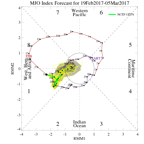
algae888 wrote:Iso thanks for the Ray of Hope as I for one have been one of the most hopeful on here this winter. Looking at the guidance the last several days the ensembles have shifted the truogh to the West and have the persistent Ridge in the east. With the mjo Amplified and in favorable phases plus your comments on the Strat I was wondering if there are other drivers that are overcoming the drivers I just mentioned or as you put it guidance is having a tough time with the transition? You would think we would start to see changes post day 7 at this time but they seem to be trending worse.Isotherm wrote:I dont usually like to use this phraseology, but I think some (not here) might be falling into the same traps of the past few months, namely, priotizing model guidance over pattern indicators, when it should be the reverse. LR will seem impossible if one sways with the tides of daily model variance. Model performance has beeb abysmal post D7 this winter. Usually model data will correct to solutions congruous with exogenous forcing mechanisms. If they don't, there exists a logical flaw in the analysis which must be remedied. But I remain confident we are not done.
I certainly will not speak for Tom as he has proven this winter he can speak for himself. But for me when looking at an ensemble forecast one has to realize that is the collective avg of all the individual members. There are all sorts of solns this fr out in time with big changes a foot. It looks to me the models are def struggling. That large mean trough in the west is likely a product of two separate troughs rather than one mean trough IMHO. As a result of appearing as one large mean trough the result down stream has to be to amplify the SE ridge; however, as we move closer in time and the more and more ens members begin to catch onto the real soln, whatever that may be, I expect to see some form of higher heights develop in between these two areas, SW CONUS and W Canada. Once, or IF, this happens you should begin to see what I outlined above where the pole ward ridging over Alaska drives the trough into the middle of the country. If this happens the SE ridge will begin to appear less and less prominent.
Any time large scale pattern drivers or enhancers sow anomalous changes such as a SSWE, or extremely strong MJO pulse, or a change from a +EPO to -EPO it will take a little time to be realized until the chages them selves begin to take place. I personally do not believe that models have inputs from the SOI value on its own, but the SOI is a product of the pressure differences between Darwin and Tahiti so yes models do have that input in its output; however, the changes that a crashing SOI, or change in pressures between these two areas thousands of miles apart against a specific base state will not be realized until the changes themselves begin to take shape over the Trop Pac first which are just beginning now and will cont to shift over the next 5-10days. Only then will those changes translate to down stream effects for our sensible weather; therefore models should correct as the new input is enetered into the equations as we go on in time. Same thing with stratosphere changes.
sroc4- Admin

- Posts : 8331
Join date : 2013-01-07
Re: Long Range Thread 13.0
![]() by CPcantmeasuresnow Sat Feb 18, 2017 7:40 pm
by CPcantmeasuresnow Sat Feb 18, 2017 7:40 pm
sroc4 wrote:Zalgae888 wrote:Iso thanks for the Ray of Hope as I for one have been one of the most hopeful on here this winter. Looking at the guidance the last several days the ensembles have shifted the truogh to the West and have the persistent Ridge in the east. With the mjo Amplified and in favorable phases plus your comments on the Strat I was wondering if there are other drivers that are overcoming the drivers I just mentioned or as you put it guidance is having a tough time with the transition? You would think we would start to see changes post day 7 at this time but they seem to be trending worse.Isotherm wrote:I dont usually like to use this phraseology, but I think some (not here) might be falling into the same traps of the past few months, namely, priotizing model guidance over pattern indicators, when it should be the reverse. LR will seem impossible if one sways with the tides of daily model variance. Model performance has beeb abysmal post D7 this winter. Usually model data will correct to solutions congruous with exogenous forcing mechanisms. If they don't, there exists a logical flaw in the analysis which must be remedied. But I remain confident we are not done.
I certainly will not speak for Tom as he has proven this winter he can speak for himself. But for me when looking at an ensemble forecast one has to realize that is the collective avg of all the individual members. There are all sorts of solns this fr out in time with big changes a foot. It looks to me the models are def struggling. That large mean trough in the west is likely a product of two separate troughs rather than one mean trough IMHO. As a result of appearing as one large mean trough the result down stream has to be to amplify the SE ridge; however, as we move closer in time and the more and more ens members begin to catch onto the real soln, whatever that may be, I expect to see some form of higher heights develop in between these two areas, SW CONUS and W Canada. Once, or IF, this happens you should begin to see what I outlined above where the pole ward ridging over Alaska drives the trough into the middle of the country. If this happens the SE ridge will begin to appear less and less prominent.
Any time large scale pattern drivers or enhancers sow anomalous changes such as a SSWE, or extremely strong MJO pulse, or a change from a +EPO to -EPO it will take a little time to be realized until the chages them selves begin to take place. I personally do not believe that models have inputs from the SOI value on its own, but the SOI is a product of the pressure differences between Darwin and Tahiti so yes models do have that input in its output; however, the changes that a crashing SOI, or change in pressures between these two areas thousands of miles apart against a specific base state will not be realized until the changes themselves begin to take shape over the Trop Pac first which are just beginning now and will cont to shift over the next 5-10days. Only then will those changes translate to down stream effects for our sensible weather; therefore models should correct as the new input is enetered into the equations as we go on in time. Same thing with stratosphere changes.
I don't comment on these posts often enough but sometimes it feels like stealing reading the insights many of the experts post here for free. Thanks again.
CPcantmeasuresnow- Wx Statistician Guru

- Posts : 7274
Join date : 2013-01-07
Re: Long Range Thread 13.0
![]() by Frank_Wx Sun Feb 19, 2017 9:25 am
by Frank_Wx Sun Feb 19, 2017 9:25 am
1. Will it be west, east, or Modoki based?
2. Will it be weak, moderate or strong?
It's VERY early and VERY possible there may not be an El Nino. I'm just pointing out seasonal models and what they show at the moment. This includes ECM and JAMSTEC
_________________
_______________________________________________________________________________________________________
CLICK HERE to view NJ Strong Snowstorm Classifications

Frank_Wx- Godzilla Seeker
- Posts : 21305
Reputation : 328
Join date : 2013-01-05
Age : 31
Location : Jersey City, NJ -

Re: Long Range Thread 13.0
![]() by Frank_Wx Sun Feb 19, 2017 9:26 am
by Frank_Wx Sun Feb 19, 2017 9:26 am
_________________
_______________________________________________________________________________________________________
CLICK HERE to view NJ Strong Snowstorm Classifications
Frank_Wx- Godzilla Seeker
- Posts : 21305
Reputation : 328
Join date : 2013-01-05
Age : 31
Location : Jersey City, NJ -
Re: Long Range Thread 13.0
![]() by nutleyblizzard Sun Feb 19, 2017 10:47 am
by nutleyblizzard Sun Feb 19, 2017 10:47 am
Very unlikely we have a strong El Nino considering we recently just got over one. West and weak however would work out very well for us.Frank_Wx wrote:Weak Nino and Modoki would be a combination that gives us the best chance of colder than normal weather for the east. We saw last season what a strong El Nino is capable of doing

nutleyblizzard- Senior Enthusiast

- Posts : 1952
Reputation : 41
Join date : 2014-01-30
Age : 58
Location : Nutley, new jersey
Re: Long Range Thread 13.0
![]() by Guest Sun Feb 19, 2017 11:01 am
by Guest Sun Feb 19, 2017 11:01 am
Frank_Wx wrote:Kinda hate typing this, but seasonal models suggest El Nino returns next winter. 2 big questions are:
1. Will it be west, east, or Modoki based?
2. Will it be weak, moderate or strong?
It's VERY early and VERY possible there may not be an El Nino. I'm just pointing out seasonal models and what they show at the moment. This includes ECM and JAMSTEC
Frank Honest question. no disrespect intended!! The question is Does it even matter? Last year El Nino and this year La nina and the temperatures were a torch both winters and snowfall IMBY and most is the same. this is the frustrating part for myself and probably a lot of others who don't have the depth of scientific knowledge some of you have. all these different names, MJO forecasts, SOI this PNA that, NAO whatever and the last 2 winters were absolute torches. (yes i know my snowfall totals were still above avg. both winters) This leads me even more to ask DOES LR FORECASTING AND THE NINA/NINO STATE EVEN MATTER ANYMORE?
Guest- Guest
Re: Long Range Thread 13.0
![]() by Frank_Wx Sun Feb 19, 2017 6:52 pm
by Frank_Wx Sun Feb 19, 2017 6:52 pm
syosnow94 wrote:Frank_Wx wrote:Kinda hate typing this, but seasonal models suggest El Nino returns next winter. 2 big questions are:
1. Will it be west, east, or Modoki based?
2. Will it be weak, moderate or strong?
It's VERY early and VERY possible there may not be an El Nino. I'm just pointing out seasonal models and what they show at the moment. This includes ECM and JAMSTEC
Frank Honest question. no disrespect intended!! The question is Does it even matter? Last year El Nino and this year La nina and the temperatures were a torch both winters and snowfall IMBY and most is the same. this is the frustrating part for myself and probably a lot of others who don't have the depth of scientific knowledge some of you have. all these different names, MJO forecasts, SOI this PNA that, NAO whatever and the last 2 winters were absolute torches. (yes i know my snowfall totals were still above avg. both winters) This leads me even more to ask DOES LR FORECASTING AND THE NINA/NINO STATE EVEN MATTER ANYMORE?
All about amplitude. Strong vs. Weak El Nino makes a huge difference to our sensible weather. I don't have the time to give you analogs, but if you research weak El Nino winter's you'll likely find them to be more wintry (mainly colder) than strong El Nino winters.
_________________
_______________________________________________________________________________________________________
CLICK HERE to view NJ Strong Snowstorm Classifications
Frank_Wx- Godzilla Seeker
- Posts : 21305
Reputation : 328
Join date : 2013-01-05
Age : 31
Location : Jersey City, NJ -
Re: Long Range Thread 13.0
![]() by Frank_Wx Mon Feb 20, 2017 9:35 am
by Frank_Wx Mon Feb 20, 2017 9:35 am
_________________
_______________________________________________________________________________________________________
CLICK HERE to view NJ Strong Snowstorm Classifications
Frank_Wx- Godzilla Seeker
- Posts : 21305
Reputation : 328
Join date : 2013-01-05
Age : 31
Location : Jersey City, NJ -
Re: Long Range Thread 13.0
![]() by weatherwatchermom Mon Feb 20, 2017 9:48 am
by weatherwatchermom Mon Feb 20, 2017 9:48 am
Frank_Wx wrote:The GFS and EURO show a couple of cutters. Saturday this weekend and Thursday next week. The GFS actually has 2 next week (Monday and Thursday). I still feel there may be a period of wintry weather to take advantage of the first week of March as the NAO and AO both look to go negative. However, I'm not getting my hopes up on a true -NAO just yet. Let's see how we look about a week from today. If this time next week models still show a -NAO, then maybe we could squeak out another winter storm in early March before spring comes full force.
Thanks Frank for always keeping us informed...will say it again glass half empty for us snow lovers this sucks!! and I hope there is one more shot of snow!! glass half full....we can all get a head start on spring and being outdoors and possibly have 2 snow days that will cut the school year so we can start summer vacation sooner...hope you have a good day!!

weatherwatchermom- Senior Enthusiast
- Posts : 3735
Reputation : 77
Join date : 2014-11-25
Age : 60
Location : Hazlet Township, NJ
Re: Long Range Thread 13.0
![]() by Frank_Wx Mon Feb 20, 2017 10:00 am
by Frank_Wx Mon Feb 20, 2017 10:00 am

_________________
_______________________________________________________________________________________________________
CLICK HERE to view NJ Strong Snowstorm Classifications
Frank_Wx- Godzilla Seeker
- Posts : 21305
Reputation : 328
Join date : 2013-01-05
Age : 31
Location : Jersey City, NJ -
Re: Long Range Thread 13.0
![]() by Frank_Wx Mon Feb 20, 2017 10:00 am
by Frank_Wx Mon Feb 20, 2017 10:00 am
weatherwatchermom wrote:Frank_Wx wrote:The GFS and EURO show a couple of cutters. Saturday this weekend and Thursday next week. The GFS actually has 2 next week (Monday and Thursday). I still feel there may be a period of wintry weather to take advantage of the first week of March as the NAO and AO both look to go negative. However, I'm not getting my hopes up on a true -NAO just yet. Let's see how we look about a week from today. If this time next week models still show a -NAO, then maybe we could squeak out another winter storm in early March before spring comes full force.
Thanks Frank for always keeping us informed...will say it again glass half empty for us snow lovers this sucks!! and I hope there is one more shot of snow!! glass half full....we can all get a head start on spring and being outdoors and possibly have 2 snow days that will cut the school year so we can start summer vacation sooner...hope you have a good day!!
Getting back those snow days is a huge win for sure. Feels nice.
_________________
_______________________________________________________________________________________________________
CLICK HERE to view NJ Strong Snowstorm Classifications
Frank_Wx- Godzilla Seeker
- Posts : 21305
Reputation : 328
Join date : 2013-01-05
Age : 31
Location : Jersey City, NJ -
Re: Long Range Thread 13.0
![]() by Armando Salvadore Mon Feb 20, 2017 10:11 am
by Armando Salvadore Mon Feb 20, 2017 10:11 am
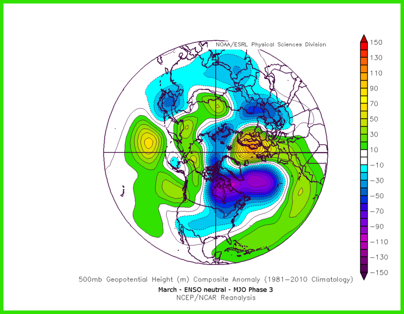
Regarding Frank's statement, just saw the 0z GEFS and EPS. Both are pretty much locked in on that early march NINA depiction with the north pacific ridge, western trough, and SE ridge in conjunction with a +NAO/AO. 0Z EURO and GFS has a system near the 28th following a preceding cold front, but again, no arctic air source really to be found by then. However, i'm intrigued for the 2nd week of march as well. It appears we see the mean trough swing east, the TPV pushes south, and a Scandinavian block manifests, which penetrates into Greenland a bit and allows positive heights build over the pole to a certain extent. Fittingly, this would match the eastern hemisphere forcing, which is shown by the March composite. So, this would match our ideas of maybe one last shot or so, before a major mid month warming occurs.
Oh and severe weather looks to pick up real quick for the south, TN/MI valleys!

Armando Salvadore- Advanced Forecaster

- Posts : 171
Reputation : 0
Join date : 2016-12-23
Location : Springfield, NJ
Re: Long Range Thread 13.0
![]() by Frank_Wx Mon Feb 20, 2017 10:13 am
by Frank_Wx Mon Feb 20, 2017 10:13 am
_________________
_______________________________________________________________________________________________________
CLICK HERE to view NJ Strong Snowstorm Classifications
Frank_Wx- Godzilla Seeker
- Posts : 21305
Reputation : 328
Join date : 2013-01-05
Age : 31
Location : Jersey City, NJ -
Re: Long Range Thread 13.0
![]() by Armando Salvadore Mon Feb 20, 2017 10:18 am
by Armando Salvadore Mon Feb 20, 2017 10:18 am

Armando Salvadore- Advanced Forecaster
- Posts : 171
Reputation : 0
Join date : 2016-12-23
Location : Springfield, NJ
Re: Long Range Thread 13.0
![]() by algae888 Mon Feb 20, 2017 12:05 pm
by algae888 Mon Feb 20, 2017 12:05 pm

algae888- Advanced Forecaster
- Posts : 5311
Reputation : 46
Join date : 2013-02-05
Age : 61
Location : mt. vernon, new york
Re: Long Range Thread 13.0
![]() by CPcantmeasuresnow Mon Feb 20, 2017 2:52 pm
by CPcantmeasuresnow Mon Feb 20, 2017 2:52 pm
Frank_Wx wrote:The GFS and EURO show a couple of cutters. Saturday this weekend and Thursday next week. The GFS actually has 2 next week (Monday and Thursday). I still feel there may be a period of wintry weather to take advantage of the first week of March as the NAO and AO both look to go negative. However, I'm not getting my hopes up on a true -NAO just yet. Let's see how we look about a week from today. If this time next week models still show a -NAO, then maybe we could squeak out another winter storm in early March before spring comes full force.
So spring could be full force in March now huh? It use to come in April and mid to late April if anything sometimes not till May. In another 10 years it will be coming in February, this year I think it has despite still having a snow covered landscape, which I'll guess is gone by Friday.
I know it's banter but my frustration with these warm winters is nearing the breaking point. I may as well move down to Virginia because that's what our winters are starting to feel like.
Sign me disheartened in Orange, which I'm thinking of changing my screen name to.

CPcantmeasuresnow- Wx Statistician Guru
- Posts : 7274
Reputation : 230
Join date : 2013-01-07
Age : 103
Location : Eastern Orange County, NY
Re: Long Range Thread 13.0
![]() by Isotherm Mon Feb 20, 2017 3:00 pm
by Isotherm Mon Feb 20, 2017 3:00 pm
Isotherm- Advanced Forecaster
- Posts : 231
Reputation : 4
Join date : 2014-09-01
Age : 33
Location : Monmouth County, NJ -
Re: Long Range Thread 13.0
![]() by amugs Mon Feb 20, 2017 3:29 pm
by amugs Mon Feb 20, 2017 3:29 pm
Isotherm wrote:Depending upon stratospheric behavior and other variables, I'm not convinced we jump right into prolonged spring weather in mid march. But first things first. Still looks on track for a 7 to 10 day (potentially) window of opportunity (targeting Mar 2 through 14 or so). The tropospheric blocking coincides with mechanisms highlighted here. It may be transient, but no one ever said protracted winter pattern. There will be a sufficient window for another snow event as we have been discussing.
Tom models are starting to hint at the early time frame next week of winter returning - well from this Aprilish weather we have been experiencing. Analog years for a weak nina torch February to a follow up wintry March are teh following according to JB:
Torch Feb

To this fro March

I think we are in a for an oh poop where peeps are expecting this torch to run the table through March and into summer but we have learned from past experiences before that there is some fight left for ol man winter.
GEFS: LR out but woudl fall into the atmospheric realm of what we are seeing as far as MJO and SOI along with the strat perturbation. Could be a very interesting first couple of weeks of March. Need well timed storms to help combat sun angle as we get in the second week and beyond if it were to come to fruition.
EURO takes us through 8 then to1 then 2 and now 3 - this aligns with start warming and warming at the High Latitudes atmospherically.

12z GEFS forming the arctic bridge over the top - ONLY 12 days away HAHAHA! BUT this is what Tom is referring to I suspect

_________________
Mugs
AKA:King: Snow Weenie
Self Proclaimed
WINTER 2014-15 : 55.12" +.02 for 6 coatings (avg. 35")
WINTER 2015-16 Total - 29.8" (Avg 35")
WINTER 2016-17 : 39.5" so far

amugs- Advanced Forecaster - Mod

- Posts : 15093
Reputation : 213
Join date : 2013-01-07
Age : 54
Location : Hillsdale,NJ
Re: Long Range Thread 13.0
![]() by billg315 Mon Feb 20, 2017 8:47 pm
by billg315 Mon Feb 20, 2017 8:47 pm

billg315- Advanced Forecaster - Mod
- Posts : 4462
Reputation : 185
Join date : 2015-01-24
Age : 50
Location : Flemington, NJ
Re: Long Range Thread 13.0
![]() by Frank_Wx Tue Feb 21, 2017 7:57 am
by Frank_Wx Tue Feb 21, 2017 7:57 am
_________________
_______________________________________________________________________________________________________
CLICK HERE to view NJ Strong Snowstorm Classifications
Frank_Wx- Godzilla Seeker
- Posts : 21305
Reputation : 328
Join date : 2013-01-05
Age : 31
Location : Jersey City, NJ -
Re: Long Range Thread 13.0
![]() by Snow88 Tue Feb 21, 2017 4:39 pm
by Snow88 Tue Feb 21, 2017 4:39 pm

Snow88- Senior Enthusiast
- Posts : 2193
Reputation : 4
Join date : 2013-01-09
Age : 35
Location : Brooklyn, NY
Re: Long Range Thread 13.0
![]() by SENJsnowman Tue Feb 21, 2017 7:00 pm
by SENJsnowman Tue Feb 21, 2017 7:00 pm
Snow88 wrote:The best chance of snowfall for the east will be the first 2 weeks of March. After that, warm weather might take over and hold for good.
A warmer March and April? Not really a bad thing IMO! Love the snow, but for me nothing beats 64 with a soft steady breeze.
SENJsnowman- Senior Enthusiast
- Posts : 1186
Reputation : 61
Join date : 2017-01-06
Age : 51
Location : Bayville, NJ
Re: Long Range Thread 13.0
![]() by CPcantmeasuresnow Tue Feb 21, 2017 9:49 pm
by CPcantmeasuresnow Tue Feb 21, 2017 9:49 pm
SENJsnowman wrote:Snow88 wrote:The best chance of snowfall for the east will be the first 2 weeks of March. After that, warm weather might take over and hold for good.
A warmer March and April? Not really a bad thing IMO! Love the snow, but for me nothing beats 64 with a soft steady breeze.
20 months in a row of above normal temperatures why would March be any different? Answer, it won't be.
CPcantmeasuresnow- Wx Statistician Guru
- Posts : 7274
Reputation : 230
Join date : 2013-01-07
Age : 103
Location : Eastern Orange County, NY
Re: Long Range Thread 13.0
![]() by dkodgis Wed Feb 22, 2017 12:16 am
by dkodgis Wed Feb 22, 2017 12:16 am
http://www.accuweather.com/en/weather-blogs/abrams/the-northeast-will-have-some-may-in-february-but-march-starts-next-week/70000919
and gosh a neophyte like me has trouble following the technical stuff but he makes a data-driven decision out of it.

dkodgis- Senior Enthusiast
- Posts : 2496
Reputation : 98
Join date : 2013-12-29
Re: Long Range Thread 13.0
![]() by amugs Wed Feb 22, 2017 8:03 am
by amugs Wed Feb 22, 2017 8:03 am
Tim isotherm here is just genius peeps and we are so fortunate to have him here as well as Armondo joining us this year.
Tom said watch circa March 2, feels like Roman times with the circa, but this map is showing the pattern shifting to what could be a very acting stormy and colder period for the 1st half of March. In banter I said 3 storm in first couple weeks of March and posted analog maps above from JB. This if comes to fruition will make Springnlovers cry and winter "one mor time" plus weenies rejioce.

_________________
Mugs
AKA:King: Snow Weenie
Self Proclaimed
WINTER 2014-15 : 55.12" +.02 for 6 coatings (avg. 35")
WINTER 2015-16 Total - 29.8" (Avg 35")
WINTER 2016-17 : 39.5" so far
amugs- Advanced Forecaster - Mod
- Posts : 15093
Reputation : 213
Join date : 2013-01-07
Age : 54
Location : Hillsdale,NJ
Re: Long Range Thread 13.0
![]() by Frank_Wx Wed Feb 22, 2017 8:05 am
by Frank_Wx Wed Feb 22, 2017 8:05 am
_________________
_______________________________________________________________________________________________________
CLICK HERE to view NJ Strong Snowstorm Classifications
Frank_Wx- Godzilla Seeker
- Posts : 21305
Reputation : 328
Join date : 2013-01-05
Age : 31
Location : Jersey City, NJ -
Re: Long Range Thread 13.0
![]() by Armando Salvadore Wed Feb 22, 2017 9:35 am
by Armando Salvadore Wed Feb 22, 2017 9:35 am
Armando Salvadore- Advanced Forecaster
- Posts : 171
Reputation : 0
Join date : 2016-12-23
Location : Springfield, NJ
Page 27 of 40 • 1 ... 15 ... 26, 27, 28 ... 33 ... 40 ![]()
|
|
|