
 Search
Long Range Thread 13.0
Page 14 of 40 •  1 ... 8 ... 13, 14, 15 ... 27 ... 40
 ![]()
Re: Long Range Thread 13.0
![]() by CPcantmeasuresnow Sun Feb 05, 2017 8:58 am
by CPcantmeasuresnow Sun Feb 05, 2017 8:58 am
13 straight days of a solid snow cover here so I shouldn't be complaining but already foreseeing losing it by Wednesday a Thursday snowfall would be a Gods send.
CPcantmeasuresnow- Wx Statistician Guru

- Posts : 7274
Join date : 2013-01-07
Re: Long Range Thread 13.0
![]() by Guest Sun Feb 05, 2017 9:01 am
by Guest Sun Feb 05, 2017 9:01 am
Guest- Guest
Re: Long Range Thread 13.0
![]() by Snow88 Sun Feb 05, 2017 9:09 am
by Snow88 Sun Feb 05, 2017 9:09 am
syosnow94 wrote:This storm threat for Thursday does not make sense meteorologically IMO. The cutter on Tuesday into Wednesday will be followed by strong NW winds gusting into Thursday at over 40mph. HOW THEN CAN A STORM RIDE UP THE COAST WHEN EVERYTHING IN THE ATMOSPHERE IS FIGHTING AGAINST ITS MOVEMENT AND PUSHING IT OTS? doesn't jive for me. Zero confidence in this one for me. I know we are all frustrated and hoping but let's be realistic.
We had the same thing last year. A wave running the trough. 100 percent possible. Lets be realistic.

Snow88- Senior Enthusiast

- Posts : 2193
Reputation : 4
Join date : 2013-01-09
Age : 35
Location : Brooklyn, NY
Re: Long Range Thread 13.0
![]() by Snow88 Sun Feb 05, 2017 9:10 am
by Snow88 Sun Feb 05, 2017 9:10 am
Snow88- Senior Enthusiast
- Posts : 2193
Reputation : 4
Join date : 2013-01-09
Age : 35
Location : Brooklyn, NY
Re: Long Range Thread 13.0
![]() by Snow88 Sun Feb 05, 2017 9:16 am
by Snow88 Sun Feb 05, 2017 9:16 am
Snow88- Senior Enthusiast
- Posts : 2193
Reputation : 4
Join date : 2013-01-09
Age : 35
Location : Brooklyn, NY
Re: Long Range Thread 13.0
![]() by skinsfan1177 Sun Feb 05, 2017 9:38 am
by skinsfan1177 Sun Feb 05, 2017 9:38 am

skinsfan1177- Senior Enthusiast
- Posts : 4485
Reputation : 35
Join date : 2013-01-07
Age : 46
Location : Point Pleasant Boro
Re: Long Range Thread 13.0
![]() by skinsfan1177 Sun Feb 05, 2017 9:39 am
by skinsfan1177 Sun Feb 05, 2017 9:39 am
Snow88 wrote:Also, AO and PNA look great this morning moving forward. PNA will be rising and AO is going downhill.
Great points snow
skinsfan1177- Senior Enthusiast
- Posts : 4485
Reputation : 35
Join date : 2013-01-07
Age : 46
Location : Point Pleasant Boro
Re: Long Range Thread 13.0
![]() by skinsfan1177 Sun Feb 05, 2017 9:43 am
by skinsfan1177 Sun Feb 05, 2017 9:43 am
syosnow94 wrote:This storm threat for Thursday does not make sense meteorologically IMO. The cutter on Tuesday into Wednesday will be followed by strong NW winds gusting into Thursday at over 40mph. HOW THEN CAN A STORM RIDE UP THE COAST WHEN EVERYTHING IN THE ATMOSPHERE IS FIGHTING AGAINST ITS MOVEMENT AND PUSHING IT OTS? doesn't jive for me. Zero confidence in this one for me. I know we are all frustrated and hoping but let's be realistic.
Cutter is backing off now on the models giving spacing between them.
skinsfan1177- Senior Enthusiast
- Posts : 4485
Reputation : 35
Join date : 2013-01-07
Age : 46
Location : Point Pleasant Boro
Re: Long Range Thread 13.0
![]() by Snow88 Sun Feb 05, 2017 9:43 am
by Snow88 Sun Feb 05, 2017 9:43 am
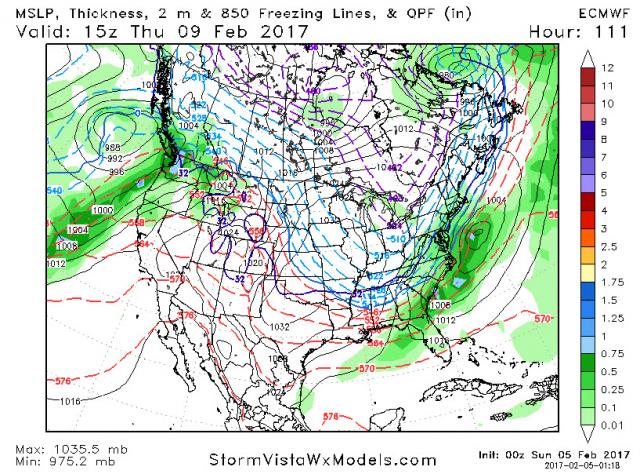
http://www.stormvistawxmodels.com/img/nam/current/06z/NAM_MSLPThickQPF_na_f60.png
Snow88- Senior Enthusiast
- Posts : 2193
Reputation : 4
Join date : 2013-01-09
Age : 35
Location : Brooklyn, NY
Re: Long Range Thread 13.0
![]() by algae888 Sun Feb 05, 2017 9:46 am
by algae888 Sun Feb 05, 2017 9:46 am

algae888- Advanced Forecaster

- Posts : 5311
Reputation : 46
Join date : 2013-02-05
Age : 61
Location : mt. vernon, new york
Re: Long Range Thread 13.0
![]() by Guest Sun Feb 05, 2017 10:01 am
by Guest Sun Feb 05, 2017 10:01 am
GOD I HOPE IM WRONG
Guest- Guest
Re: Long Range Thread 13.0
![]() by sroc4 Sun Feb 05, 2017 10:15 am
by sroc4 Sun Feb 05, 2017 10:15 am
syosnow94 wrote:This storm threat for Thursday does not make sense meteorologically IMO. The cutter on Tuesday into Wednesday will be followed by strong NW winds gusting into Thursday at over 40mph. HOW THEN CAN A STORM RIDE UP THE COAST WHEN EVERYTHING IN THE ATMOSPHERE IS FIGHTING AGAINST ITS MOVEMENT AND PUSHING IT OTS? doesn't jive for me. Zero confidence in this one for me. I know we are all frustrated and hoping but let's be realistic.
Jimmy the NW winds after the cutter moves into SE Canada will have zero to do with whether or not this other system develops. It's all about the interactions at 18,000ft or 500mb. No one get too excited just yet. If the chance hold by this time tomorrow then it's time to zero in on the details.
_________________
"In weather and in life, there's no winning and losing; there's only winning and learning."
WINTER 2012/2013 TOTALS 43.65"WINTER 2017/2018 TOTALS 62.85" WINTER 2022/2023 TOTALS 4.9"
WINTER 2013/2014 TOTALS 64.85"WINTER 2018/2019 TOTALS 14.25" WINTER 2023/2024 TOTALS 13.1"
WINTER 2014/2015 TOTALS 71.20"WINTER 2019/2020 TOTALS 6.35"
WINTER 2015/2016 TOTALS 35.00"WINTER 2020/2021 TOTALS 37.75"
WINTER 2016/2017 TOTALS 42.25"WINTER 2021/2022 TOTALS 31.65"

sroc4- Admin

- Posts : 8331
Reputation : 301
Join date : 2013-01-07
Location : Wading River, LI
Re: Long Range Thread 13.0
![]() by CPcantmeasuresnow Sun Feb 05, 2017 10:16 am
by CPcantmeasuresnow Sun Feb 05, 2017 10:16 am
syosnow94 wrote:Snow88. I hope I'm wrong and maybe my pessimism is a defense mechanism to not get disappointed but......."let's be realistic" is probably the worst thing you could have said for this winter because a miss is realistic based on what has happened probably even likely
GOD I HOPE IM WRONG
If you are wrong I feel there should be some type of penalty for rainmongering and torchmongering, as a mental health specialist you should know we all need hope, hope is a good thing.
https://www.youtube.com/watch?v=9K30e9O3Nng

CPcantmeasuresnow- Wx Statistician Guru
- Posts : 7274
Reputation : 230
Join date : 2013-01-07
Age : 103
Location : Eastern Orange County, NY
Re: Long Range Thread 13.0
![]() by Guest Sun Feb 05, 2017 10:18 am
by Guest Sun Feb 05, 2017 10:18 am
Guest- Guest
Re: Long Range Thread 13.0
![]() by sroc4 Sun Feb 05, 2017 10:22 am
by sroc4 Sun Feb 05, 2017 10:22 am
syosnow94 wrote:Ok Scott I'll trust you on this one paean. Here's to hoping! On a separate note I was out by you on Thursday small game hunting. Rocky Point and Calverton. Haven't been in a few years. What a change and NOT for the better
You said it Jim. Def built up out here. And not slowing down.
_________________
"In weather and in life, there's no winning and losing; there's only winning and learning."
WINTER 2012/2013 TOTALS 43.65"WINTER 2017/2018 TOTALS 62.85" WINTER 2022/2023 TOTALS 4.9"
WINTER 2013/2014 TOTALS 64.85"WINTER 2018/2019 TOTALS 14.25" WINTER 2023/2024 TOTALS 13.1"
WINTER 2014/2015 TOTALS 71.20"WINTER 2019/2020 TOTALS 6.35"
WINTER 2015/2016 TOTALS 35.00"WINTER 2020/2021 TOTALS 37.75"
WINTER 2016/2017 TOTALS 42.25"WINTER 2021/2022 TOTALS 31.65"
sroc4- Admin
- Posts : 8331
Reputation : 301
Join date : 2013-01-07
Location : Wading River, LI
Re: Long Range Thread 13.0
![]() by Guest Sun Feb 05, 2017 10:25 am
by Guest Sun Feb 05, 2017 10:25 am
Guest- Guest
Re: Long Range Thread 13.0
![]() by Frank_Wx Sun Feb 05, 2017 12:13 pm
by Frank_Wx Sun Feb 05, 2017 12:13 pm
_________________
_______________________________________________________________________________________________________
CLICK HERE to view NJ Strong Snowstorm Classifications

Frank_Wx- Godzilla Seeker
- Posts : 21305
Reputation : 328
Join date : 2013-01-05
Age : 31
Location : Jersey City, NJ -

Re: Long Range Thread 13.0
![]() by Frank_Wx Sun Feb 05, 2017 12:16 pm
by Frank_Wx Sun Feb 05, 2017 12:16 pm
Madonne

_________________
_______________________________________________________________________________________________________
CLICK HERE to view NJ Strong Snowstorm Classifications
Frank_Wx- Godzilla Seeker
- Posts : 21305
Reputation : 328
Join date : 2013-01-05
Age : 31
Location : Jersey City, NJ -
Re: Long Range Thread 13.0
![]() by weatherwatchermom Sun Feb 05, 2017 12:16 pm
by weatherwatchermom Sun Feb 05, 2017 12:16 pm
Frank_Wx wrote:The 12z GFS splits the 10mb Strat PV by Day 10. If true, end of FEB into March could be colder and stormier than normal.
from your mouth to the weather gods ears!!!

weatherwatchermom- Senior Enthusiast
- Posts : 3743
Reputation : 77
Join date : 2014-11-25
Age : 60
Location : Hazlet Township, NJ
Re: Long Range Thread 13.0
![]() by Frank_Wx Sun Feb 05, 2017 12:21 pm
by Frank_Wx Sun Feb 05, 2017 12:21 pm

_________________
_______________________________________________________________________________________________________
CLICK HERE to view NJ Strong Snowstorm Classifications
Frank_Wx- Godzilla Seeker
- Posts : 21305
Reputation : 328
Join date : 2013-01-05
Age : 31
Location : Jersey City, NJ -
Re: Long Range Thread 13.0
![]() by amugs Sun Feb 05, 2017 12:29 pm
by amugs Sun Feb 05, 2017 12:29 pm
Time will tell.
MJO projected going into very strong Phase 8 that woudl be a driver to the pattern. We have to see what the models show for the heights in teh tahiti to Darwin region and Eastern Indian Ocean. IF the pressures stay high then we could be rocking. Still need the sun to help out and calm the heck down after the last two week post spike adn coronal hole explosion!
_________________
Mugs
AKA:King: Snow Weenie
Self Proclaimed
WINTER 2014-15 : 55.12" +.02 for 6 coatings (avg. 35")
WINTER 2015-16 Total - 29.8" (Avg 35")
WINTER 2016-17 : 39.5" so far

amugs- Advanced Forecaster - Mod

- Posts : 15093
Reputation : 213
Join date : 2013-01-07
Age : 54
Location : Hillsdale,NJ
Re: Long Range Thread 13.0
![]() by Isotherm Sun Feb 05, 2017 1:10 pm
by Isotherm Sun Feb 05, 2017 1:10 pm
The only divergence I see is that the ECMWF continues propagating a coherent MJO through P1, but the GFS now seems to be backing off on the forward progression. I think it's likely attempting to kill the wave too quickly. I tend to lean toward the ECM based guidance due to the fact that I am not seeing anything which would necessarily preclude the maintenance of a coherent wave. Even with the MJO, the GFS is still splitting the 10hpa which is good news because it indicates the forcing will be sufficiently potent regardless.
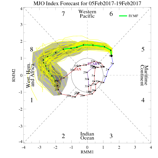
https://i.servimg.com/u/f37/18/98/60/93/ecmf_p10.gif
Isotherm- Advanced Forecaster
- Posts : 231
Reputation : 4
Join date : 2014-09-01
Age : 33
Location : Monmouth County, NJ -
Re: Long Range Thread 13.0
![]() by algae888 Mon Feb 06, 2017 4:10 am
by algae888 Mon Feb 06, 2017 4:10 am

new

when most jumped off the cliff.

algae888- Advanced Forecaster
- Posts : 5311
Reputation : 46
Join date : 2013-02-05
Age : 61
Location : mt. vernon, new york
Re: Long Range Thread 13.0
![]() by Frank_Wx Mon Feb 06, 2017 7:53 am
by Frank_Wx Mon Feb 06, 2017 7:53 am
_________________
_______________________________________________________________________________________________________
CLICK HERE to view NJ Strong Snowstorm Classifications
Frank_Wx- Godzilla Seeker
- Posts : 21305
Reputation : 328
Join date : 2013-01-05
Age : 31
Location : Jersey City, NJ -
Re: Long Range Thread 13.0
![]() by Isotherm Mon Feb 06, 2017 11:26 am
by Isotherm Mon Feb 06, 2017 11:26 am
Isotherm- Advanced Forecaster
- Posts : 231
Reputation : 4
Join date : 2014-09-01
Age : 33
Location : Monmouth County, NJ -
Re: Long Range Thread 13.0
![]() by dkodgis Mon Feb 06, 2017 3:56 pm
by dkodgis Mon Feb 06, 2017 3:56 pm

dkodgis- Senior Enthusiast
- Posts : 2501
Reputation : 98
Join date : 2013-12-29
Re: Long Range Thread 13.0
![]() by algae888 Mon Feb 06, 2017 6:08 pm
by algae888 Mon Feb 06, 2017 6:08 pm

algae888- Advanced Forecaster
- Posts : 5311
Reputation : 46
Join date : 2013-02-05
Age : 61
Location : mt. vernon, new york
Page 14 of 40 • 1 ... 8 ... 13, 14, 15 ... 27 ... 40 ![]()
|
|
|