
 Search
Long Range Thread 13.0
Page 33 of 40 •  1 ... 18 ... 32, 33, 34 ... 36 ... 40
 ![]()
Re: Long Range Thread 13.0
![]() by algae888 Fri Mar 03, 2017 1:38 pm
by algae888 Fri Mar 03, 2017 1:38 pm
algae888- Advanced Forecaster

- Posts : 5311
Join date : 2013-02-05
Re: Long Range Thread 13.0
![]() by algae888 Fri Mar 03, 2017 1:45 pm
by algae888 Fri Mar 03, 2017 1:45 pm
algae888- Advanced Forecaster
- Posts : 5311
Join date : 2013-02-05
Re: Long Range Thread 13.0
![]() by algae888 Fri Mar 03, 2017 1:52 pm
by algae888 Fri Mar 03, 2017 1:52 pm

algae888- Advanced Forecaster
- Posts : 5311
Reputation : 46
Join date : 2013-02-05
Age : 61
Location : mt. vernon, new york
Re: Long Range Thread 13.0
![]() by algae888 Fri Mar 03, 2017 1:55 pm
by algae888 Fri Mar 03, 2017 1:55 pm
algae888- Advanced Forecaster
- Posts : 5311
Reputation : 46
Join date : 2013-02-05
Age : 61
Location : mt. vernon, new york
Re: Long Range Thread 13.0
![]() by Frank_Wx Fri Mar 03, 2017 1:59 pm
by Frank_Wx Fri Mar 03, 2017 1:59 pm

_________________
_______________________________________________________________________________________________________
CLICK HERE to view NJ Strong Snowstorm Classifications

Frank_Wx- Godzilla Seeker

- Posts : 21305
Reputation : 328
Join date : 2013-01-05
Age : 31
Location : Jersey City, NJ -

Re: Long Range Thread 13.0
![]() by Armando Salvadore Fri Mar 03, 2017 3:11 pm
by Armando Salvadore Fri Mar 03, 2017 3:11 pm

Armando Salvadore- Advanced Forecaster
- Posts : 171
Reputation : 0
Join date : 2016-12-23
Location : Springfield, NJ
Re: Long Range Thread 13.0
![]() by amugs Fri Mar 03, 2017 4:37 pm
by amugs Fri Mar 03, 2017 4:37 pm
Heights connect over the top from the pac PNA region to the NAO region sight that is great.
_________________
Mugs
AKA:King: Snow Weenie
Self Proclaimed
WINTER 2014-15 : 55.12" +.02 for 6 coatings (avg. 35")
WINTER 2015-16 Total - 29.8" (Avg 35")
WINTER 2016-17 : 39.5" so far

amugs- Advanced Forecaster - Mod

- Posts : 15093
Reputation : 213
Join date : 2013-01-07
Age : 54
Location : Hillsdale,NJ
Re: Long Range Thread 13.0
![]() by SENJsnowman Fri Mar 03, 2017 8:46 pm
by SENJsnowman Fri Mar 03, 2017 8:46 pm
Frank_Wx wrote:Yes, EURO does look much better than the GFS!
Is that 32 degree line a hard cut-off for the snow?
And doesn't the 540 line have some bearing on the snow?
Sorry for the basic questions...just trying to figure out if this should make the Shore's toes tingle or not...
SENJsnowman- Senior Enthusiast

- Posts : 1186
Reputation : 61
Join date : 2017-01-06
Age : 51
Location : Bayville, NJ
Re: Long Range Thread 13.0
![]() by skinsfan1177 Sat Mar 04, 2017 6:49 am
by skinsfan1177 Sat Mar 04, 2017 6:49 am

skinsfan1177- Senior Enthusiast
- Posts : 4485
Reputation : 35
Join date : 2013-01-07
Age : 46
Location : Point Pleasant Boro
Re: Long Range Thread 13.0
![]() by Frank_Wx Sat Mar 04, 2017 7:16 am
by Frank_Wx Sat Mar 04, 2017 7:16 am
_________________
_______________________________________________________________________________________________________
CLICK HERE to view NJ Strong Snowstorm Classifications
Frank_Wx- Godzilla Seeker
- Posts : 21305
Reputation : 328
Join date : 2013-01-05
Age : 31
Location : Jersey City, NJ -
Re: Long Range Thread 13.0
![]() by devsman Sat Mar 04, 2017 7:17 am
by devsman Sat Mar 04, 2017 7:17 am

devsman- Pro Enthusiast

- Posts : 424
Reputation : 4
Join date : 2014-01-01
Age : 48
Location : merrick, ny (south shore of Long Island)
Re: Long Range Thread 13.0
![]() by Frank_Wx Sat Mar 04, 2017 7:28 am
by Frank_Wx Sat Mar 04, 2017 7:28 am
It looks like the EURO has the blocking placed in a way that keeps the SE Ridge muted. GFS shows the storm as a cutter. I much rather have the EURO on my side if I had to choose.
_________________
_______________________________________________________________________________________________________
CLICK HERE to view NJ Strong Snowstorm Classifications
Frank_Wx- Godzilla Seeker
- Posts : 21305
Reputation : 328
Join date : 2013-01-05
Age : 31
Location : Jersey City, NJ -
Re: Long Range Thread 13.0
![]() by rb924119 Sat Mar 04, 2017 8:09 am
by rb924119 Sat Mar 04, 2017 8:09 am
rb924119- Meteorologist

- Posts : 6890
Reputation : 194
Join date : 2013-02-06
Age : 32
Location : Greentown, Pa
Re: Long Range Thread 13.0
![]() by Snow88 Sat Mar 04, 2017 8:23 am
by Snow88 Sat Mar 04, 2017 8:23 am
Frank_Wx wrote:Euro showed a Roidzilla around the 12th. With blocking developing, the signal is there for a potent storm as long as the Pacific cooperates. Models keep waffling with how the western ridge behaves. Regardless, I think the 10th-15th has good potential. Just gotta wait and see.
Not sure if it did show a Roidzilla. Anything higher than that? lol

Snow88- Senior Enthusiast
- Posts : 2193
Reputation : 4
Join date : 2013-01-09
Age : 35
Location : Brooklyn, NY
Re: Long Range Thread 13.0
![]() by sroc4 Sat Mar 04, 2017 8:26 am
by sroc4 Sat Mar 04, 2017 8:26 am
So feast your eyes on it now because in a little over 4 hours the next euro run comes out and it will be totally different.
500mb first; then surface...And I will post the snow map here as well so its all in one spot.....enjoy!


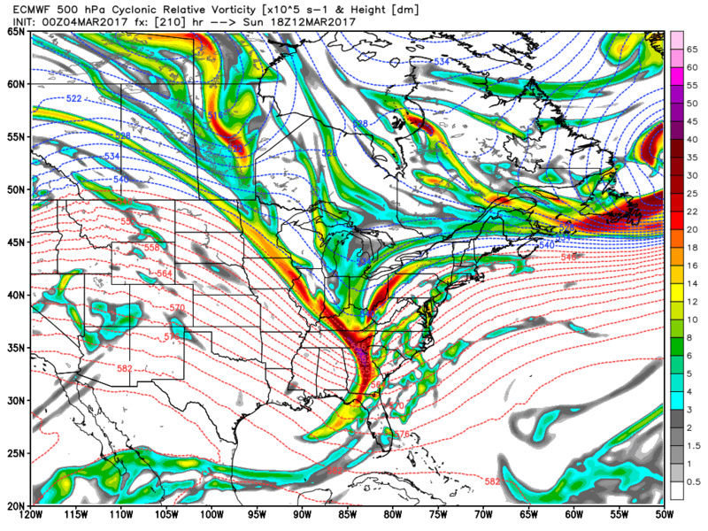
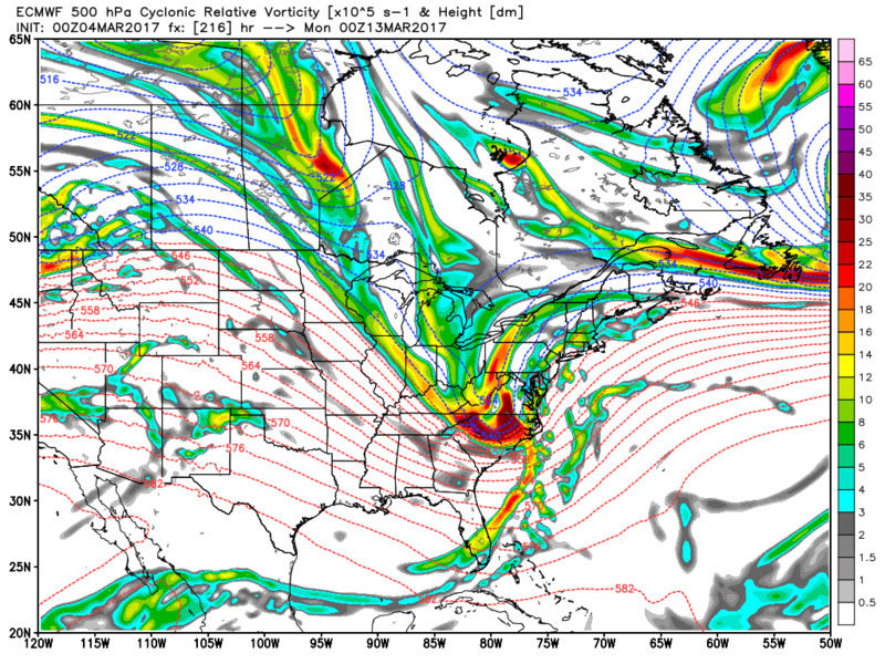

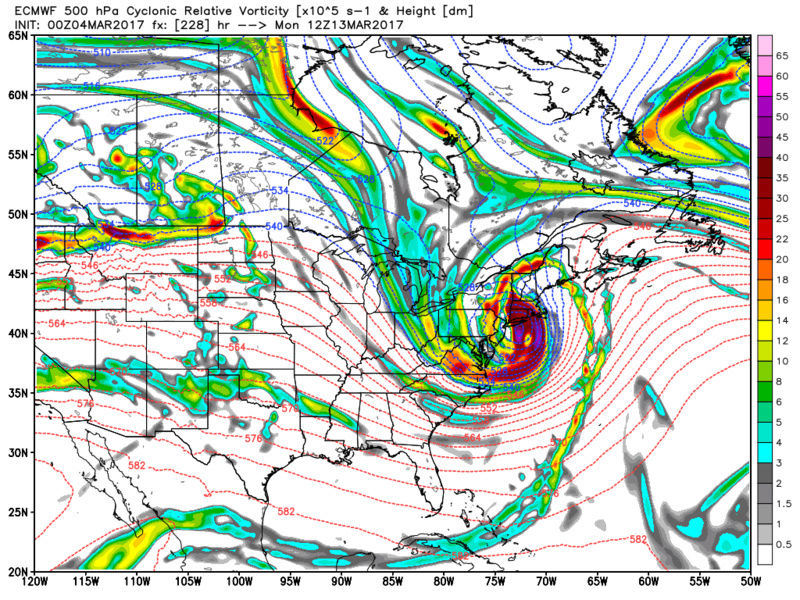
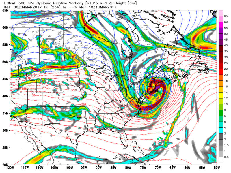
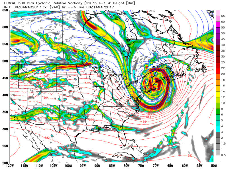
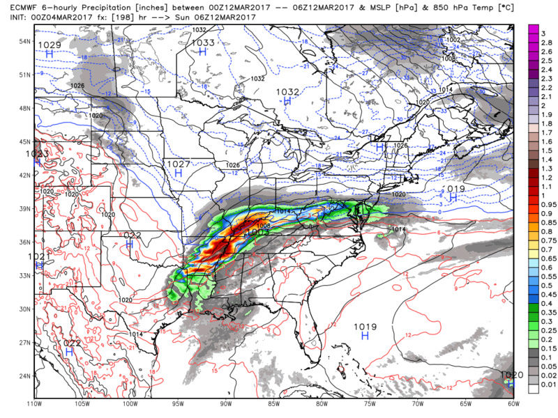
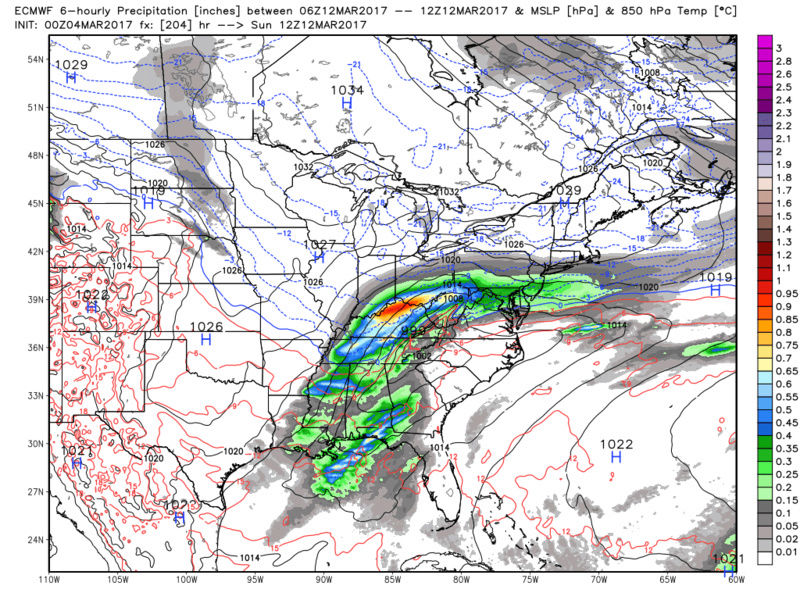


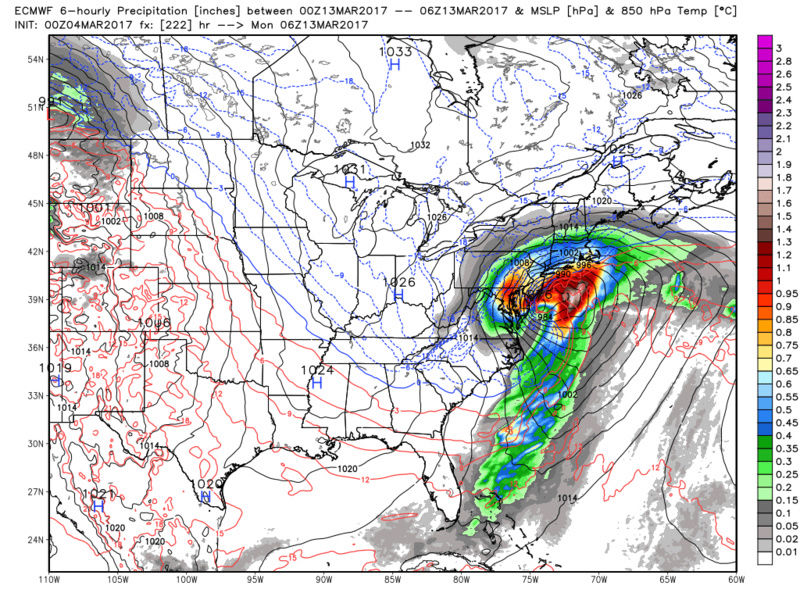

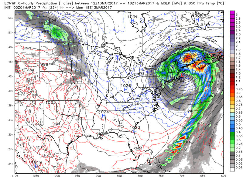
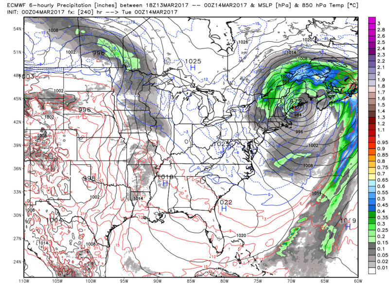
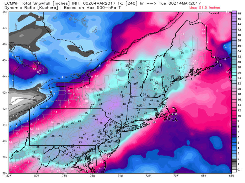
DO NOT ASK IF THIS CAN HAPPEN! The answer is yes it can, but so can pretty much everything else on the table so just gaze in wonder and remain cautiously optimistic that something comes together before we officially close the book on winter 2016/2017.
Last edited by sroc4 on Sat Mar 04, 2017 8:33 am; edited 1 time in total
_________________
"In weather and in life, there's no winning and losing; there's only winning and learning."
WINTER 2012/2013 TOTALS 43.65"WINTER 2017/2018 TOTALS 62.85" WINTER 2022/2023 TOTALS 4.9"
WINTER 2013/2014 TOTALS 64.85"WINTER 2018/2019 TOTALS 14.25" WINTER 2023/2024 TOTALS 13.1"
WINTER 2014/2015 TOTALS 71.20"WINTER 2019/2020 TOTALS 6.35"
WINTER 2015/2016 TOTALS 35.00"WINTER 2020/2021 TOTALS 37.75"
WINTER 2016/2017 TOTALS 42.25"WINTER 2021/2022 TOTALS 31.65"

sroc4- Admin
- Posts : 8331
Reputation : 301
Join date : 2013-01-07
Location : Wading River, LI
Re: Long Range Thread 13.0
![]() by sroc4 Sat Mar 04, 2017 8:28 am
by sroc4 Sat Mar 04, 2017 8:28 am
rb924119 wrote:Sorry for the lack of posting, but quite honestly, there's been nothing for me to add to the convo. Our long-range heavyweight duo of Tom and Armando have been holding their fort throughtout the last several days, with our fearless leaders providing their insight to the battle plans when appropriate. Only thing I have to say to last night's EURO Op is that with what had been said, this type of solution should not really surprise too many, as it follows the old line, "If you build it, they will come." (Anybody know the movie??? Lol) The question becomes if the Pacific can remain favorable, as again, has been stated repeatedly. That said, this is the very type of situation where I can envision models seeing this at this time frame, completely losing it in Day 7-4/3 and then bringing it back within 72 hours because of how chaotic and sensitive the upstream pattern is. In any event, at least it's some eye candy for all of us, and a great proof to Tom's earlier point "pattern recognition versus modelology, as has been the case all season..", where yet again human intuition could very well beat the models at their own game.
Please Ray. Field of Dreams!! Top 5 of all time in my book
_________________
"In weather and in life, there's no winning and losing; there's only winning and learning."
WINTER 2012/2013 TOTALS 43.65"WINTER 2017/2018 TOTALS 62.85" WINTER 2022/2023 TOTALS 4.9"
WINTER 2013/2014 TOTALS 64.85"WINTER 2018/2019 TOTALS 14.25" WINTER 2023/2024 TOTALS 13.1"
WINTER 2014/2015 TOTALS 71.20"WINTER 2019/2020 TOTALS 6.35"
WINTER 2015/2016 TOTALS 35.00"WINTER 2020/2021 TOTALS 37.75"
WINTER 2016/2017 TOTALS 42.25"WINTER 2021/2022 TOTALS 31.65"
sroc4- Admin
- Posts : 8331
Reputation : 301
Join date : 2013-01-07
Location : Wading River, LI
Re: Long Range Thread 13.0
![]() by Frank_Wx Sat Mar 04, 2017 8:30 am
by Frank_Wx Sat Mar 04, 2017 8:30 am
_________________
_______________________________________________________________________________________________________
CLICK HERE to view NJ Strong Snowstorm Classifications
Frank_Wx- Godzilla Seeker
- Posts : 21305
Reputation : 328
Join date : 2013-01-05
Age : 31
Location : Jersey City, NJ -
Re: Long Range Thread 13.0
![]() by Armando Salvadore Sat Mar 04, 2017 9:21 am
by Armando Salvadore Sat Mar 04, 2017 9:21 am
Armando Salvadore- Advanced Forecaster
- Posts : 171
Reputation : 0
Join date : 2016-12-23
Location : Springfield, NJ
Re: Long Range Thread 13.0
![]() by Armando Salvadore Sat Mar 04, 2017 2:08 pm
by Armando Salvadore Sat Mar 04, 2017 2:08 pm
Armando Salvadore- Advanced Forecaster
- Posts : 171
Reputation : 0
Join date : 2016-12-23
Location : Springfield, NJ
Re: Long Range Thread 13.0
![]() by Isotherm Sat Mar 04, 2017 3:22 pm
by Isotherm Sat Mar 04, 2017 3:22 pm
Isotherm- Advanced Forecaster
- Posts : 231
Reputation : 4
Join date : 2014-09-01
Age : 33
Location : Monmouth County, NJ -
Re: Long Range Thread 13.0
![]() by Isotherm Sat Mar 04, 2017 3:23 pm
by Isotherm Sat Mar 04, 2017 3:23 pm
Armando Salvadore wrote:And the 12z EURO tooketh... haha. Yea, basically a big flip from 0z. Keeps the TPV in the west, which allows heights to rise out ahead. Squashes any hope for a western ridge, but i should say that volatility is high and pacific evolution is crazy. Looks like the mid month warmup will occur.
Armando - see my latest post; I think I know what the issue is.
Isotherm- Advanced Forecaster
- Posts : 231
Reputation : 4
Join date : 2014-09-01
Age : 33
Location : Monmouth County, NJ -

SoulSingMG- Senior Enthusiast
- Posts : 2853
Reputation : 74
Join date : 2013-12-11
Location : Long Island City, NY
Re: Long Range Thread 13.0
![]() by algae888 Sat Mar 04, 2017 4:15 pm
by algae888 Sat Mar 04, 2017 4:15 pm
Yes i did soul. They actually improved from last night's run. Big difference from today's operational. Nobody should get their hopes up from seeing three feet of snow but a couple of decent events are still on the table.SoulSingMG wrote:Anyone see the Euro ENS?
algae888- Advanced Forecaster
- Posts : 5311
Reputation : 46
Join date : 2013-02-05
Age : 61
Location : mt. vernon, new york
Re: Long Range Thread 13.0
![]() by SoulSingMG Sat Mar 04, 2017 4:53 pm
by SoulSingMG Sat Mar 04, 2017 4:53 pm
algae888 wrote:Yes i did soul. They actually improved from last night's run. Big difference from today's operational. Nobody should get their hopes up from seeing three feet of snow but a couple of decent events are still on the table.SoulSingMG wrote:Anyone see the Euro ENS?
Agreed. I do have a feeling this winter of extremes could go out with an extreme bang though. We'll see!
SoulSingMG- Senior Enthusiast
- Posts : 2853
Reputation : 74
Join date : 2013-12-11
Location : Long Island City, NY
Re: Long Range Thread 13.0
![]() by Armando Salvadore Sun Mar 05, 2017 1:37 am
by Armando Salvadore Sun Mar 05, 2017 1:37 am
Isotherm wrote:I think I've diagnosed the causative mechanism of the extreme model variance. It's been awhile since we've seen such variance in the sub D8 period. It all emanates back to the Rossby wave break evolution in the North Pacific. We want the mid level ridge to cut-off from the mean flow such that jet is permitted to cut underneath the block in the NPAC. Last night's 00z euro cut-off the ridge, which enabled heights to lower directly underneath, thereby inducing downstream geopotential height rises over the Western US. The 12z euro keeps the mid level ridge connected to the mean flow, forcing a deeper trough in the West. This is a time at which the faster than normal Pacific jet would be helpful. Drive the flow through the wall of heights in order to adequately displace the Rossby wave cut-off block, thereby pumping the Western US heights, and subsequent further downstream results. The evolution of this wave break goes haywire post D3, so I'd expect model variance on this issue for another 1-2 days probably.
Dam good analysis/diagnosis Tom! Check out the 0z CMC, just using it as a reference, but it reflects your idea. Notice the NPAC ridge cuts off from mean flow, sets up a rex block a bit, but pumps a downstream ridge just at the right time. The blocking signal could not be stronger, but support is anomalous for it anyway. This could work.

Armando Salvadore- Advanced Forecaster
- Posts : 171
Reputation : 0
Join date : 2016-12-23
Location : Springfield, NJ
Re: Long Range Thread 13.0
![]() by Snow88 Sun Mar 05, 2017 10:37 am
by Snow88 Sun Mar 05, 2017 10:37 am
Lets see the 12z runs
Snow88- Senior Enthusiast
- Posts : 2193
Reputation : 4
Join date : 2013-01-09
Age : 35
Location : Brooklyn, NY
Re: Long Range Thread 13.0
![]() by Snow88 Sun Mar 05, 2017 11:04 am
by Snow88 Sun Mar 05, 2017 11:04 am
Snow88- Senior Enthusiast
- Posts : 2193
Reputation : 4
Join date : 2013-01-09
Age : 35
Location : Brooklyn, NY
Page 33 of 40 • 1 ... 18 ... 32, 33, 34 ... 36 ... 40 ![]()
|
|
|