
 Search
Long Range Thread 13.0
Page 29 of 40 •  1 ... 16 ... 28, 29, 30 ... 34 ... 40
 ![]()
Re: Long Range Thread 13.0
![]() by sroc4 Thu Feb 23, 2017 12:23 pm
by sroc4 Thu Feb 23, 2017 12:23 pm
Isotherm wrote:Nothing has changed from my point of view. As expected, model data transitioning in accordance with global forcing mechanisms tropospherically and stratospherically. At least one more snow event is on the table for the first half of March as the first real neg NAO of the season initiates in several days.

sroc4- Admin

- Posts : 8331
Join date : 2013-01-07
Re: Long Range Thread 13.0
![]() by Isotherm Thu Feb 23, 2017 1:11 pm
by Isotherm Thu Feb 23, 2017 1:11 pm
https://mobile.twitter.com/judah47/status/834770015656230912/photo/1
Both SSW displacements events over the past month have/will feature fairly rapid downward propagation of circulation anomalies, as evidenced by PCH.
Isotherm- Advanced Forecaster

- Posts : 231
Join date : 2014-09-01 -

Re: Long Range Thread 13.0
![]() by Isotherm Thu Feb 23, 2017 1:12 pm
by Isotherm Thu Feb 23, 2017 1:12 pm
Both SSW displacements events over the past month have/will feature fairly rapid downward propagation of circulation anomalies, as evidenced by PCH.
Isotherm- Advanced Forecaster
- Posts : 231
Reputation : 4
Join date : 2014-09-01
Age : 33
Location : Monmouth County, NJ -
Re: Long Range Thread 13.0
![]() by jmanley32 Thu Feb 23, 2017 6:04 pm
by jmanley32 Thu Feb 23, 2017 6:04 pm
sroc4 wrote:Isotherm wrote:Nothing has changed from my point of view. As expected, model data transitioning in accordance with global forcing mechanisms tropospherically and stratospherically. At least one more snow event is on the table for the first half of March as the first real neg NAO of the season initiates in several days.
10 of them scott? LOL You would think a mega frankzilla was on the cusp.

jmanley32- Senior Enthusiast

- Posts : 20513
Reputation : 108
Join date : 2013-12-12
Age : 42
Location : Yonkers, NY
Re: Long Range Thread 13.0
![]() by sroc4 Thu Feb 23, 2017 7:06 pm
by sroc4 Thu Feb 23, 2017 7:06 pm
jmanley32 wrote:sroc4 wrote:Isotherm wrote:Nothing has changed from my point of view. As expected, model data transitioning in accordance with global forcing mechanisms tropospherically and stratospherically. At least one more snow event is on the table for the first half of March as the first real neg NAO of the season initiates in several days.
10 of them scott? LOL You would think a mega frankzilla was on the cusp.
Admittedly I may have gotten carried away. lol

_________________
"In weather and in life, there's no winning and losing; there's only winning and learning."
WINTER 2012/2013 TOTALS 43.65"WINTER 2017/2018 TOTALS 62.85" WINTER 2022/2023 TOTALS 4.9"
WINTER 2013/2014 TOTALS 64.85"WINTER 2018/2019 TOTALS 14.25" WINTER 2023/2024 TOTALS 13.1"
WINTER 2014/2015 TOTALS 71.20"WINTER 2019/2020 TOTALS 6.35"
WINTER 2015/2016 TOTALS 35.00"WINTER 2020/2021 TOTALS 37.75"
WINTER 2016/2017 TOTALS 42.25"WINTER 2021/2022 TOTALS 31.65"

sroc4- Admin
- Posts : 8331
Reputation : 301
Join date : 2013-01-07
Location : Wading River, LI
Re: Long Range Thread 13.0
![]() by Frank_Wx Fri Feb 24, 2017 9:08 am
by Frank_Wx Fri Feb 24, 2017 9:08 am
An impressive -NAO block develops around March 2nd. The PV is on the wrong side of Canada (west), but colder air still flows into the east though it's on the moderated side. It is a good pattern for March standards but not one I am overly excited about.
_________________
_______________________________________________________________________________________________________
CLICK HERE to view NJ Strong Snowstorm Classifications

Frank_Wx- Godzilla Seeker
- Posts : 21305
Reputation : 328
Join date : 2013-01-05
Age : 31
Location : Jersey City, NJ -
Re: Long Range Thread 13.0
![]() by Snow88 Fri Feb 24, 2017 9:47 am
by Snow88 Fri Feb 24, 2017 9:47 am
Frank_Wx wrote:It does look like it will get colder than what we've seen lately, but for the most part it looks like average temps with maybe a 2-3 day transient stretch of below normal beginning March 4th. There is a threat of potential snow event, albeit minor, between March 4th-5th and a bigger one could loom between the 7th-12th. We'll just watch for now.
An impressive -NAO block develops around March 2nd. The PV is on the wrong side of Canada (west), but colder air still flows into the east though it's on the moderated side. It is a good pattern for March standards but not one I am overly excited about.
Not impressed? Favorable MJO, AO and NAO dropping, PNA rising with blocking.
Our 1st chance of snowfall will be next weekend and then we will have other chances. I am very excited. The other page is also excited ( you know which one ( lol

Snow88- Senior Enthusiast
- Posts : 2193
Reputation : 4
Join date : 2013-01-09
Age : 35
Location : Brooklyn, NY
Re: Long Range Thread 13.0
![]() by Snow88 Fri Feb 24, 2017 10:50 am
by Snow88 Fri Feb 24, 2017 10:50 am
Anthony Masiello
It sounds crazy but this could be the Mid Atlantic's best chance at snow all winter.
Snow88- Senior Enthusiast
- Posts : 2193
Reputation : 4
Join date : 2013-01-09
Age : 35
Location : Brooklyn, NY
Re: Long Range Thread 13.0
![]() by Armando Salvadore Fri Feb 24, 2017 3:09 pm
by Armando Salvadore Fri Feb 24, 2017 3:09 pm

Armando Salvadore- Advanced Forecaster
- Posts : 171
Reputation : 0
Join date : 2016-12-23
Location : Springfield, NJ
Re: Long Range Thread 13.0
![]() by Math23x7 Fri Feb 24, 2017 3:23 pm
by Math23x7 Fri Feb 24, 2017 3:23 pm
Math23x7- Wx Statistician Guru

- Posts : 2379
Reputation : 68
Join date : 2013-01-08
Re: Long Range Thread 13.0
![]() by Frank_Wx Fri Feb 24, 2017 4:58 pm
by Frank_Wx Fri Feb 24, 2017 4:58 pm
Snow88 wrote:Frank_Wx wrote:It does look like it will get colder than what we've seen lately, but for the most part it looks like average temps with maybe a 2-3 day transient stretch of below normal beginning March 4th. There is a threat of potential snow event, albeit minor, between March 4th-5th and a bigger one could loom between the 7th-12th. We'll just watch for now.
An impressive -NAO block develops around March 2nd. The PV is on the wrong side of Canada (west), but colder air still flows into the east though it's on the moderated side. It is a good pattern for March standards but not one I am overly excited about.
Not impressed? Favorable MJO, AO and NAO dropping, PNA rising with blocking.
Our 1st chance of snowfall will be next weekend and then we will have other chances. I am very excited. The other page is also excited ( you know which one ( lol
I meant not impressed for anything major. PV on the wrong side of the continent which enhances the risk of northern stream energy tracking to our west. I wish the NAO block was more west based.
_________________
_______________________________________________________________________________________________________
CLICK HERE to view NJ Strong Snowstorm Classifications
Frank_Wx- Godzilla Seeker
- Posts : 21305
Reputation : 328
Join date : 2013-01-05
Age : 31
Location : Jersey City, NJ -
Re: Long Range Thread 13.0
![]() by Frank_Wx Fri Feb 24, 2017 5:45 pm
by Frank_Wx Fri Feb 24, 2017 5:45 pm
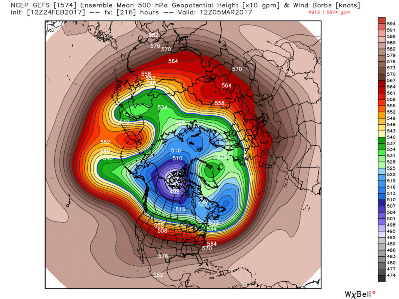
Alright, so we have an MJO moving into favorable phases which looks to bring us a period of -NAO and possibly +PNA conditions. The problem persists that the Trop PV will stay over the western side of North America. While pieces of energy will break off the main PV and travel southeast to bring us cold shots, the alignment with the STJ is not there to bring us anything significant in my mind. The northern energy has had a tendency all winter to track west of us, so we're left with Arctic fronts that may try to develop a coastal off the coast. We've had favorably placed jet streaks and well timed Pacific energy track into our area once these fronts depart. That's essentially how we've gotten our snow this season.
Also, we've seen a few times this winter where the -NAO looks legit, but once the time period arrives it's either weak or too east based. In the upcoming pattern, knowing the PV will be in western Arctic/Canada, we need a moderate west based -NAO to prevent heights from rising ahead of the northern stream energy coming out of the PJ, or even the Pacific since it looks like the EPO will be positive.
Basically what I see is a return to normal or slightly below normal weather. Keep in mind once we enter March our daily normal highs are in the 40s. And I feel below normal temps will be transient as opposed to anything sustaining. I'm a believer in seeing snowflakes fly again before winter truly ends, but I'm not a believer in any significant storm event. Maybe a light event if we can see one of these northern stream events dig south enough to keep the baroclinic zone to our S&E. With the PNA spiking and NAO heading negative, that's probably our best bet. But everything seems to want to break down. My 2 cents...
.png.ad9b4a87912df80ef5986e610e64a50e.png)
_________________
_______________________________________________________________________________________________________
CLICK HERE to view NJ Strong Snowstorm Classifications
Frank_Wx- Godzilla Seeker
- Posts : 21305
Reputation : 328
Join date : 2013-01-05
Age : 31
Location : Jersey City, NJ -
Re: Long Range Thread 13.0
![]() by Frank_Wx Fri Feb 24, 2017 5:49 pm
by Frank_Wx Fri Feb 24, 2017 5:49 pm

_________________
_______________________________________________________________________________________________________
CLICK HERE to view NJ Strong Snowstorm Classifications
Frank_Wx- Godzilla Seeker
- Posts : 21305
Reputation : 328
Join date : 2013-01-05
Age : 31
Location : Jersey City, NJ -
Re: Long Range Thread 13.0
![]() by docstox12 Fri Feb 24, 2017 6:44 pm
by docstox12 Fri Feb 24, 2017 6:44 pm
Frank_Wx wrote:Hopefully you're all making the most of the mild weather this week instead of tracking each model run for a fantasy winter storm. In middle to late January it became very obvious to me where the pattern wants to set up this winter. Over the western and mid U.S. Those areas have been clobbered with Arctic cold and snowfall, especially mountain ranges across the west. Even getting into the valleys some days. When I look at current models and what they show in the long range, it looks like much of the same.
Alright, so we have an MJO moving into favorable phases which looks to bring us a period of -NAO and possibly +PNA conditions. The problem persists that the Trop PV will stay over the western side of North America. While pieces of energy will break off the main PV and travel southeast to bring us cold shots, the alignment with the STJ is not there to bring us anything significant in my mind. The northern energy has had a tendency all winter to track west of us, so we're left with Arctic fronts that may try to develop a coastal off the coast. We've had favorably placed jet streaks and well timed Pacific energy track into our area once these fronts depart. That's essentially how we've gotten our snow this season.
Also, we've seen a few times this winter where the -NAO looks legit, but once the time period arrives it's either weak or too east based. In the upcoming pattern, knowing the PV will be in western Arctic/Canada, we need a moderate west based -NAO to prevent heights from rising ahead of the northern stream energy coming out of the PJ, or even the Pacific since it looks like the EPO will be positive.
Basically what I see is a return to normal or slightly below normal weather. Keep in mind once we enter March our daily normal highs are in the 40s. And I feel below normal temps will be transient as opposed to anything sustaining. I'm a believer in seeing snowflakes fly again before winter truly ends, but I'm not a believer in any significant storm event. Maybe a light event if we can see one of these northern stream events dig south enough to keep the baroclinic zone to our S&E. With the PNA spiking and NAO heading negative, that's probably our best bet. But everything seems to want to break down. My 2 cents...
EXACTLY Frank! The North Central and Sierra Nevada's got pounded this winter as well as Northern new England.That was the pattern and once they are set, it's like in cement.Just my analog opinion.

docstox12- Wx Statistician Guru
- Posts : 8502
Reputation : 222
Join date : 2013-01-07
Age : 73
Location : Monroe NY
Snow88- Senior Enthusiast
- Posts : 2193
Reputation : 4
Join date : 2013-01-09
Age : 35
Location : Brooklyn, NY
Re: Long Range Thread 13.0
![]() by sroc4 Sat Feb 25, 2017 7:56 am
by sroc4 Sat Feb 25, 2017 7:56 am

_________________
"In weather and in life, there's no winning and losing; there's only winning and learning."
WINTER 2012/2013 TOTALS 43.65"WINTER 2017/2018 TOTALS 62.85" WINTER 2022/2023 TOTALS 4.9"
WINTER 2013/2014 TOTALS 64.85"WINTER 2018/2019 TOTALS 14.25" WINTER 2023/2024 TOTALS 13.1"
WINTER 2014/2015 TOTALS 71.20"WINTER 2019/2020 TOTALS 6.35"
WINTER 2015/2016 TOTALS 35.00"WINTER 2020/2021 TOTALS 37.75"
WINTER 2016/2017 TOTALS 42.25"WINTER 2021/2022 TOTALS 31.65"
sroc4- Admin
- Posts : 8331
Reputation : 301
Join date : 2013-01-07
Location : Wading River, LI
Re: Long Range Thread 13.0
![]() by Frank_Wx Sat Feb 25, 2017 8:25 am
by Frank_Wx Sat Feb 25, 2017 8:25 am
_________________
_______________________________________________________________________________________________________
CLICK HERE to view NJ Strong Snowstorm Classifications
Frank_Wx- Godzilla Seeker
- Posts : 21305
Reputation : 328
Join date : 2013-01-05
Age : 31
Location : Jersey City, NJ -
Snow88- Senior Enthusiast
- Posts : 2193
Reputation : 4
Join date : 2013-01-09
Age : 35
Location : Brooklyn, NY
Re: Long Range Thread 13.0
![]() by jmanley32 Sat Feb 25, 2017 9:02 pm
by jmanley32 Sat Feb 25, 2017 9:02 pm
im just go watch and see with the open mind that we have seen all our snow this year. if im wrong grwat, do not care for any nickle and dime events which i what frank said may be possible, imo big one or keep this weather up.Snow88 wrote:GFS is clipper city
jmanley32- Senior Enthusiast
- Posts : 20513
Reputation : 108
Join date : 2013-12-12
Age : 42
Location : Yonkers, NY
Re: Long Range Thread 13.0
![]() by dkodgis Sat Feb 25, 2017 9:03 pm
by dkodgis Sat Feb 25, 2017 9:03 pm

dkodgis- Senior Enthusiast
- Posts : 2495
Reputation : 98
Join date : 2013-12-29
Re: Long Range Thread 13.0
![]() by jmanley32 Sat Feb 25, 2017 9:08 pm
by jmanley32 Sat Feb 25, 2017 9:08 pm
i was speaking imby highs in 40s 50s all week.dkodgis wrote:Yo! Look at the low forecast for next Fri night. Around here, 16 degrees. Tomorrow and the rest of the week, not much better. Take the ski coat back out.
jmanley32- Senior Enthusiast
- Posts : 20513
Reputation : 108
Join date : 2013-12-12
Age : 42
Location : Yonkers, NY
Re: Long Range Thread 13.0
![]() by Math23x7 Sat Feb 25, 2017 9:09 pm
by Math23x7 Sat Feb 25, 2017 9:09 pm
Math23x7- Wx Statistician Guru
- Posts : 2379
Reputation : 68
Join date : 2013-01-08
Re: Long Range Thread 13.0
![]() by CPcantmeasuresnow Sat Feb 25, 2017 11:11 pm
by CPcantmeasuresnow Sat Feb 25, 2017 11:11 pm
jmanley32 wrote:i was speaking imby highs in 40s 50s all week.dkodgis wrote:Yo! Look at the low forecast for next Fri night. Around here, 16 degrees. Tomorrow and the rest of the week, not much better. Take the ski coat back out.
It's just not realistic to think temperatures anywhere close to this can continue and if they did it's pretty scary. Spring in Late February is just insane.

CPcantmeasuresnow- Wx Statistician Guru
- Posts : 7274
Reputation : 230
Join date : 2013-01-07
Age : 103
Location : Eastern Orange County, NY
Re: Long Range Thread 13.0
![]() by Snow88 Sun Feb 26, 2017 9:43 am
by Snow88 Sun Feb 26, 2017 9:43 am
There is another storm to watch for mid March but right now the models have it hitting SNE northward.
Snow88- Senior Enthusiast
- Posts : 2193
Reputation : 4
Join date : 2013-01-09
Age : 35
Location : Brooklyn, NY
Re: Long Range Thread 13.0
![]() by dkodgis Sun Feb 26, 2017 11:15 am
by dkodgis Sun Feb 26, 2017 11:15 am
http://www.foxnews.com/science/2017/02/23/blob-in-pacific-ocean-linked-to-spike-in-ozone.html
dkodgis- Senior Enthusiast
- Posts : 2495
Reputation : 98
Join date : 2013-12-29
Re: Long Range Thread 13.0
![]() by amugs Sun Feb 26, 2017 11:34 am
by amugs Sun Feb 26, 2017 11:34 am
_________________
Mugs
AKA:King: Snow Weenie
Self Proclaimed
WINTER 2014-15 : 55.12" +.02 for 6 coatings (avg. 35")
WINTER 2015-16 Total - 29.8" (Avg 35")
WINTER 2016-17 : 39.5" so far

amugs- Advanced Forecaster - Mod

- Posts : 15093
Reputation : 213
Join date : 2013-01-07
Age : 54
Location : Hillsdale,NJ
Re: Long Range Thread 13.0
![]() by Dunnzoo Sun Feb 26, 2017 12:42 pm
by Dunnzoo Sun Feb 26, 2017 12:42 pm
amugs wrote:Models barking at the High Latitude West NAO Block. Looks like from the end of this week through middle of the month then we go back to warmth.
Just need a small window of cold with incoming precip... staying hopeful we're not done yet. Pretty hard after a day like the last few!
_________________
Janet
Snowfall winter of 2023-2024 17.5"
Snowfall winter of 2022-2023 6.0"
Snowfall winter of 2021-2022 17.6" 1" sleet 2/25/22
Snowfall winter of 2020-2021 51.1"
Snowfall winter of 2019-2020 8.5"
Snowfall winter of 2018-2019 25.1"
Snowfall winter of 2017-2018 51.9"
Snowfall winter of 2016-2017 45.6"
Snowfall winter of 2015-2016 29.5"
Snowfall winter of 2014-2015 50.55"
Snowfall winter of 2013-2014 66.5"

Dunnzoo- Senior Enthusiast - Mod
- Posts : 4887
Reputation : 68
Join date : 2013-01-11
Age : 62
Location : Westwood, NJ
Page 29 of 40 • 1 ... 16 ... 28, 29, 30 ... 34 ... 40 ![]()
|
|
|