
 Search
Long Range Thread 13.0
Page 34 of 40 •  1 ... 18 ... 33, 34, 35 ... 40
 ![]()
Re: Long Range Thread 13.0
![]() by Snow88 Sun Mar 05, 2017 10:37 am
by Snow88 Sun Mar 05, 2017 10:37 am
Lets see the 12z runs
Snow88- Senior Enthusiast

- Posts : 2193
Join date : 2013-01-09
Re: Long Range Thread 13.0
![]() by Snow88 Sun Mar 05, 2017 11:04 am
by Snow88 Sun Mar 05, 2017 11:04 am
Snow88- Senior Enthusiast
- Posts : 2193
Join date : 2013-01-09
Re: Long Range Thread 13.0
![]() by rb924119 Sun Mar 05, 2017 11:13 am
by rb924119 Sun Mar 05, 2017 11:13 am
rb924119- Meteorologist

- Posts : 6889
Reputation : 194
Join date : 2013-02-06
Age : 32
Location : Greentown, Pa
Re: Long Range Thread 13.0
![]() by rb924119 Sun Mar 05, 2017 11:17 am
by rb924119 Sun Mar 05, 2017 11:17 am
rb924119- Meteorologist
- Posts : 6889
Reputation : 194
Join date : 2013-02-06
Age : 32
Location : Greentown, Pa
Re: Long Range Thread 13.0
![]() by amugs Sun Mar 05, 2017 11:17 am
by amugs Sun Mar 05, 2017 11:17 am
As Isotherm pointed out, there is interference in the models depiction of this massive percolating jetstream.
As Ray pointed out that we have seen this so many times with the model shuffle, has a storm losses it only to bring it back within 72 hrs and it makes jumps or strides to the original idea. May not be exact but the idea is there. The players are on the field here for us, will it be a full or partial NE corridor storm? We just need the west coast to help us out and get some heights to rise. I feel with this set up we will see tjis happen, how much remains to be seen.
If we can hook the NAO over the top to the PAC then watch out.
There will be laughable if not 180 degree difrences in the model runs. Tom pointed this out two days ago it takes time for our supercomputers to digest and play out the variables.
_________________
Mugs
AKA:King: Snow Weenie
Self Proclaimed
WINTER 2014-15 : 55.12" +.02 for 6 coatings (avg. 35")
WINTER 2015-16 Total - 29.8" (Avg 35")
WINTER 2016-17 : 39.5" so far

amugs- Advanced Forecaster - Mod

- Posts : 15093
Reputation : 213
Join date : 2013-01-07
Age : 54
Location : Hillsdale,NJ

Snow88- Senior Enthusiast
- Posts : 2193
Reputation : 4
Join date : 2013-01-09
Age : 35
Location : Brooklyn, NY
Re: Long Range Thread 13.0
![]() by Snow88 Sun Mar 05, 2017 11:25 am
by Snow88 Sun Mar 05, 2017 11:25 am
Snow88- Senior Enthusiast
- Posts : 2193
Reputation : 4
Join date : 2013-01-09
Age : 35
Location : Brooklyn, NY
Re: Long Range Thread 13.0
![]() by rb924119 Sun Mar 05, 2017 11:31 am
by rb924119 Sun Mar 05, 2017 11:31 am
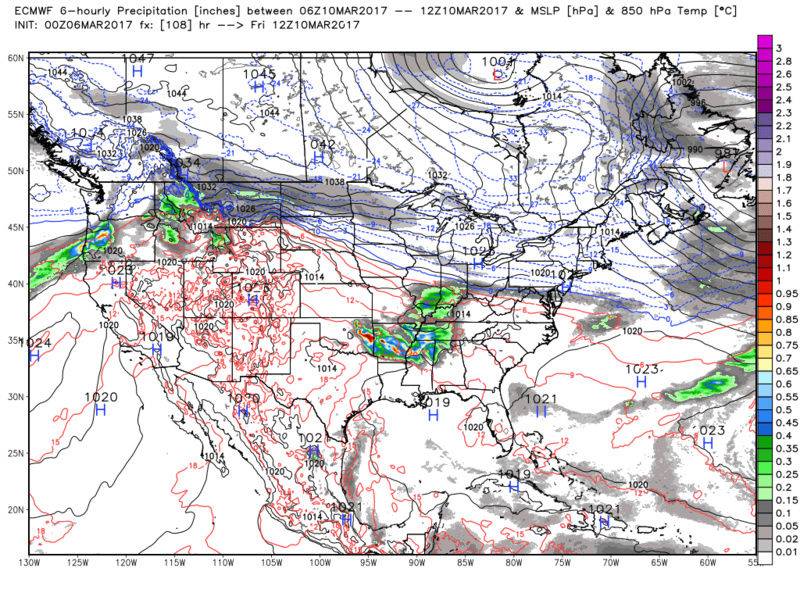
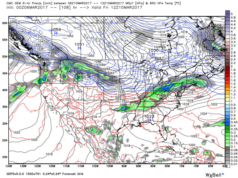
Snow88 wrote:http://www.stormvistawxmodels.com/img/cmc/current/12z/CMC_MSLPThickQPF_na_f177.png?1364096147
Check the evolution of the pattern BEHIND this one on the CMC......now THAT could raise eyebrows
rb924119- Meteorologist
- Posts : 6889
Reputation : 194
Join date : 2013-02-06
Age : 32
Location : Greentown, Pa
Snow88- Senior Enthusiast
- Posts : 2193
Reputation : 4
Join date : 2013-01-09
Age : 35
Location : Brooklyn, NY
Re: Long Range Thread 13.0
![]() by Armando Salvadore Sun Mar 05, 2017 6:26 pm
by Armando Salvadore Sun Mar 05, 2017 6:26 pm


Armando Salvadore- Advanced Forecaster

- Posts : 171
Reputation : 0
Join date : 2016-12-23
Location : Springfield, NJ
Re: Long Range Thread 13.0
![]() by Math23x7 Sun Mar 05, 2017 7:20 pm
by Math23x7 Sun Mar 05, 2017 7:20 pm
Armando Salvadore wrote:Crazy similar look to what the 12z guidance has for next weekend.... March 1999 analog leading up to the snow event that occurred. 2 things; Lack of pacific amplification in this analog AND notice how robust the blocking ridge is. Relying on the baroclinic zone will be a component to this situation next weekend. I really am liking our odds.
I remember that event. It gave us several inches of snow. I was eight years old and had off from school that day. Me and my sister built a nice snowman for the day off. Soon after this, however, it warmed up quickly. Of course, because of the compact snowman we built (and because it was in the shade), it stood a bit later. Five days after the snow much of the snow had melted. However, the snowman (albeit no longer resembling one, rather a several inch tall snowbank), was still intact.
Math23x7- Wx Statistician Guru

- Posts : 2379
Reputation : 68
Join date : 2013-01-08
Re: Long Range Thread 13.0
![]() by amugs Sun Mar 05, 2017 8:50 pm
by amugs Sun Mar 05, 2017 8:50 pm
Looking at this weekend to the with for what could be multiple chances. Nothing etched in stone of course but the potential from what I am seeing at h5 is there.

_________________
Mugs
AKA:King: Snow Weenie
Self Proclaimed
WINTER 2014-15 : 55.12" +.02 for 6 coatings (avg. 35")
WINTER 2015-16 Total - 29.8" (Avg 35")
WINTER 2016-17 : 39.5" so far
amugs- Advanced Forecaster - Mod
- Posts : 15093
Reputation : 213
Join date : 2013-01-07
Age : 54
Location : Hillsdale,NJ
Re: Long Range Thread 13.0
![]() by Snow88 Sun Mar 05, 2017 11:07 pm
by Snow88 Sun Mar 05, 2017 11:07 pm
1st wave is way further south
Snow88- Senior Enthusiast
- Posts : 2193
Reputation : 4
Join date : 2013-01-09
Age : 35
Location : Brooklyn, NY
Snow88- Senior Enthusiast
- Posts : 2193
Reputation : 4
Join date : 2013-01-09
Age : 35
Location : Brooklyn, NY
Re: Long Range Thread 13.0
![]() by Snow88 Sun Mar 05, 2017 11:23 pm
by Snow88 Sun Mar 05, 2017 11:23 pm
Overrunning followed by a coastal
Snow88- Senior Enthusiast
- Posts : 2193
Reputation : 4
Join date : 2013-01-09
Age : 35
Location : Brooklyn, NY
Snow88- Senior Enthusiast
- Posts : 2193
Reputation : 4
Join date : 2013-01-09
Age : 35
Location : Brooklyn, NY
Re: Long Range Thread 13.0
![]() by jmanley32 Sun Mar 05, 2017 11:42 pm
by jmanley32 Sun Mar 05, 2017 11:42 pm

jmanley32- Senior Enthusiast
- Posts : 20513
Reputation : 108
Join date : 2013-12-12
Age : 42
Location : Yonkers, NY
Re: Long Range Thread 13.0
![]() by jmanley32 Sun Mar 05, 2017 11:42 pm
by jmanley32 Sun Mar 05, 2017 11:42 pm
GFS is more like 14-20.Snow88 wrote:GFS is 12+ for a lot of the area
jmanley32- Senior Enthusiast
- Posts : 20513
Reputation : 108
Join date : 2013-12-12
Age : 42
Location : Yonkers, NY

Snow88- Senior Enthusiast
- Posts : 2193
Reputation : 4
Join date : 2013-01-09
Age : 35
Location : Brooklyn, NY
Re: Long Range Thread 13.0
![]() by Snow88 Mon Mar 06, 2017 12:00 am
by Snow88 Mon Mar 06, 2017 12:00 am
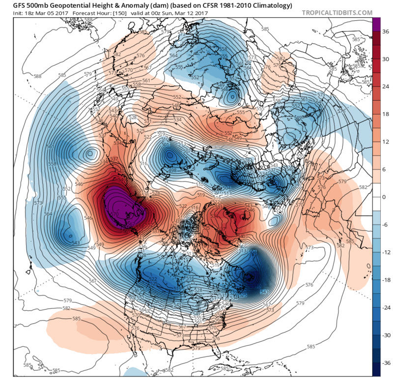
We are bordering on KU-level hemispheric evolution now on much of the medium range ensemble guidance as we move into the Day 5-10 period. Westward movement of vorticity from Greenland into the Davis Straight and Central Canada with a closed and/or notable polar block circulation have been known to preclude some of the more prolific Northeast US snowstorms on record. In addition, the elongation of the tropospheric polar vortex over Southeast Canada suggests that cold, well sourced high pressure systems will be meandering to our north over Northern New England and Southeastern Canada. An active Pacific pattern ensures multiple disturbances ejecting eastwards into this airmass.
While the individual details are yet to be determined, and we don't have a handle on individual pieces of energy, I can say with confidence that at the current juncture this is the best looking pre-loading pattern over the higher latitudes I have seen in quite some time.
Snow88- Senior Enthusiast
- Posts : 2193
Reputation : 4
Join date : 2013-01-09
Age : 35
Location : Brooklyn, NY


SoulSingMG- Senior Enthusiast
- Posts : 2853
Reputation : 74
Join date : 2013-12-11
Location : Long Island City, NY
Re: Long Range Thread 13.0
![]() by algae888 Mon Mar 06, 2017 1:58 am
by algae888 Mon Mar 06, 2017 1:58 am

algae888- Advanced Forecaster
- Posts : 5311
Reputation : 46
Join date : 2013-02-05
Age : 61
Location : mt. vernon, new york
Re: Long Range Thread 13.0
![]() by jake732 Mon Mar 06, 2017 7:13 am
by jake732 Mon Mar 06, 2017 7:13 am

jake732- Pro Enthusiast

- Posts : 449
Reputation : 0
Join date : 2016-01-03
Location : lakewood, nj -

Re: Long Range Thread 13.0
![]() by sroc4 Mon Mar 06, 2017 7:16 am
by sroc4 Mon Mar 06, 2017 7:16 am


_________________
"In weather and in life, there's no winning and losing; there's only winning and learning."
WINTER 2012/2013 TOTALS 43.65"WINTER 2017/2018 TOTALS 62.85" WINTER 2022/2023 TOTALS 4.9"
WINTER 2013/2014 TOTALS 64.85"WINTER 2018/2019 TOTALS 14.25" WINTER 2023/2024 TOTALS 13.1"
WINTER 2014/2015 TOTALS 71.20"WINTER 2019/2020 TOTALS 6.35"
WINTER 2015/2016 TOTALS 35.00"WINTER 2020/2021 TOTALS 37.75"
WINTER 2016/2017 TOTALS 42.25"WINTER 2021/2022 TOTALS 31.65"

sroc4- Admin

- Posts : 8331
Reputation : 301
Join date : 2013-01-07
Location : Wading River, LI
Re: Long Range Thread 13.0
![]() by sroc4 Mon Mar 06, 2017 7:23 am
by sroc4 Mon Mar 06, 2017 7:23 am
jake732 wrote:Y is this place so frikin dead???? We have a couple storms to track!!! It ain't July u know.
Many people have thrown in their proverbial white towels Jake. And with the LR too often showing the goods only to fall flat I think many are hesitant. However, rest assured if in another 24-48 hrs if the euro starts to comes back to the GFS/CMC with the first system regarding the board you will be saying................
_________________
"In weather and in life, there's no winning and losing; there's only winning and learning."
WINTER 2012/2013 TOTALS 43.65"WINTER 2017/2018 TOTALS 62.85" WINTER 2022/2023 TOTALS 4.9"
WINTER 2013/2014 TOTALS 64.85"WINTER 2018/2019 TOTALS 14.25" WINTER 2023/2024 TOTALS 13.1"
WINTER 2014/2015 TOTALS 71.20"WINTER 2019/2020 TOTALS 6.35"
WINTER 2015/2016 TOTALS 35.00"WINTER 2020/2021 TOTALS 37.75"
WINTER 2016/2017 TOTALS 42.25"WINTER 2021/2022 TOTALS 31.65"
sroc4- Admin
- Posts : 8331
Reputation : 301
Join date : 2013-01-07
Location : Wading River, LI
Re: Long Range Thread 13.0
![]() by dkodgis Mon Mar 06, 2017 7:32 am
by dkodgis Mon Mar 06, 2017 7:32 am

dkodgis- Senior Enthusiast
- Posts : 2495
Reputation : 98
Join date : 2013-12-29
Re: Long Range Thread 13.0
![]() by docstox12 Mon Mar 06, 2017 7:37 am
by docstox12 Mon Mar 06, 2017 7:37 am
sroc4 wrote:jake732 wrote:Y is this place so frikin dead???? We have a couple storms to track!!! It ain't July u know.
Many people have thrown in their proverbial white towels Jake. And with the LR too often showing the goods only to fall flat I think many are hesitant. However, rest assured if in another 24-48 hrs if the euro starts to comes back to the GFS/CMC with the first system regarding the board you will be saying................

OMG Doc I'm screaming laughing with tears!! Grand slam home run!!!!

docstox12- Wx Statistician Guru
- Posts : 8502
Reputation : 222
Join date : 2013-01-07
Age : 73
Location : Monroe NY
Page 34 of 40 • 1 ... 18 ... 33, 34, 35 ... 40 ![]()
|
|
|