
 Search
2017 General Tropical Cyclone Discussion Thread
Page 12 of 40 •  1 ... 7 ... 11, 12, 13 ... 26 ... 40
 ![]()
Re: 2017 General Tropical Cyclone Discussion Thread
![]() by rb924119 Mon Aug 21, 2017 6:45 pm
by rb924119 Mon Aug 21, 2017 6:45 pm
rb924119- Meteorologist

- Posts : 6890
Join date : 2013-02-06
Re: 2017 General Tropical Cyclone Discussion Thread
![]() by jmanley32 Mon Aug 21, 2017 6:59 pm
by jmanley32 Mon Aug 21, 2017 6:59 pm
wow if harvey and the ec system had met up that would have been a historic storm. def go interesting to watch, amazing a system in texas is key to a ec storm. rb dont say hostoric lol. u got the last part wrong lol, totally kidding. keep us poated. al all valid points and same sroc agree no sleeping on 92l, cmc has it stall.rb924119 wrote:I'm definitely not sleeping on 92L, either, Scott (see my last post from a few days ago). For kicks, you see how freakin' close the 18z GFS Op was to something, dare I say, HISTORIC for the East Coast????
jmanley32- Senior Enthusiast

- Posts : 20513
Join date : 2013-12-12
Re: 2017 General Tropical Cyclone Discussion Thread
![]() by jmanley32 Mon Aug 21, 2017 7:00 pm
by jmanley32 Mon Aug 21, 2017 7:00 pm

jmanley32- Senior Enthusiast
- Posts : 20513
Reputation : 108
Join date : 2013-12-12
Age : 42
Location : Yonkers, NY
Re: 2017 General Tropical Cyclone Discussion Thread
![]() by rb924119 Mon Aug 21, 2017 7:01 pm
by rb924119 Mon Aug 21, 2017 7:01 pm
rb924119- Meteorologist
- Posts : 6890
Reputation : 194
Join date : 2013-02-06
Age : 32
Location : Greentown, Pa
Re: 2017 General Tropical Cyclone Discussion Thread
![]() by algae888 Mon Aug 21, 2017 7:32 pm
by algae888 Mon Aug 21, 2017 7:32 pm

algae888- Advanced Forecaster

- Posts : 5311
Reputation : 46
Join date : 2013-02-05
Age : 61
Location : mt. vernon, new york
Re: 2017 General Tropical Cyclone Discussion Thread
![]() by rb924119 Mon Aug 21, 2017 7:55 pm
by rb924119 Mon Aug 21, 2017 7:55 pm
algae888 wrote:Scott Rb and Jon things are definitely getting interesting and not sleeping on anything especially Harvey and how he becomes a big player in the whole setup. My point has always been that nothing was going to happen this week with this impressive trough that's going to drop in on Wednesday and last through the weekend. Anything and everything is still possible after that.
And you definitely called that one; hat tip to you, my friend. I know I was expecting the pattern to evolve differently than it did, which is why the first part of my outlook with what was supposed to become 93L being a potential threat busted. However, my concern for 92L in the same region that it is currently progged to start becoming an issue at least seems to continue to hold water haha
rb924119- Meteorologist
- Posts : 6890
Reputation : 194
Join date : 2013-02-06
Age : 32
Location : Greentown, Pa
Re: 2017 General Tropical Cyclone Discussion Thread
![]() by jmanley32 Mon Aug 21, 2017 11:57 pm
by jmanley32 Mon Aug 21, 2017 11:57 pm
jmanley32- Senior Enthusiast
- Posts : 20513
Reputation : 108
Join date : 2013-12-12
Age : 42
Location : Yonkers, NY
Re: 2017 General Tropical Cyclone Discussion Thread
![]() by Snow88 Tue Aug 22, 2017 6:17 am
by Snow88 Tue Aug 22, 2017 6:17 am
GFS,CMC and Euro likes Texas in regards to Harvey

Snow88- Senior Enthusiast
- Posts : 2193
Reputation : 4
Join date : 2013-01-09
Age : 35
Location : Brooklyn, NY
Re: 2017 General Tropical Cyclone Discussion Thread
![]() by rb924119 Tue Aug 22, 2017 7:05 am
by rb924119 Tue Aug 22, 2017 7:05 am
rb924119- Meteorologist
- Posts : 6890
Reputation : 194
Join date : 2013-02-06
Age : 32
Location : Greentown, Pa
Re: 2017 General Tropical Cyclone Discussion Thread
![]() by jmanley32 Tue Aug 22, 2017 8:07 am
by jmanley32 Tue Aug 22, 2017 8:07 am
can you just say if it's worry that it may do something or worry that it's going pfff. Cuz nhc now hinting at it having little chance and going ots. And Harvey remnants move norththen nw to go so I don't see that as a issue of course that's well down line. I'm not sure it is 92lnthat develops cuz it's way far out and unless it doesn't move at all I don't see how that system comes from 92l.rb924119 wrote:92L has me worried. Not gonna say otherwise given the looks of the pattern and ensembles right now.
jmanley32- Senior Enthusiast
- Posts : 20513
Reputation : 108
Join date : 2013-12-12
Age : 42
Location : Yonkers, NY
Re: 2017 General Tropical Cyclone Discussion Thread
![]() by rb924119 Tue Aug 22, 2017 9:23 am
by rb924119 Tue Aug 22, 2017 9:23 am
rb924119- Meteorologist
- Posts : 6890
Reputation : 194
Join date : 2013-02-06
Age : 32
Location : Greentown, Pa
Re: 2017 General Tropical Cyclone Discussion Thread
![]() by jmanley32 Tue Aug 22, 2017 9:34 am
by jmanley32 Tue Aug 22, 2017 9:34 am
jmanley32- Senior Enthusiast
- Posts : 20513
Reputation : 108
Join date : 2013-12-12
Age : 42
Location : Yonkers, NY
Re: 2017 General Tropical Cyclone Discussion Thread
![]() by rb924119 Tue Aug 22, 2017 2:43 pm
by rb924119 Tue Aug 22, 2017 2:43 pm
rb924119- Meteorologist
- Posts : 6890
Reputation : 194
Join date : 2013-02-06
Age : 32
Location : Greentown, Pa
Re: 2017 General Tropical Cyclone Discussion Thread
![]() by rb924119 Tue Aug 22, 2017 3:01 pm
by rb924119 Tue Aug 22, 2017 3:01 pm
rb924119- Meteorologist
- Posts : 6890
Reputation : 194
Join date : 2013-02-06
Age : 32
Location : Greentown, Pa
Re: 2017 General Tropical Cyclone Discussion Thread
![]() by jmanley32 Tue Aug 22, 2017 3:33 pm
by jmanley32 Tue Aug 22, 2017 3:33 pm
So Irma has the possibility to come up but how, it looks like there a pretty strong blocking high that holds her below cap hatteras, is it possile theres a split or it retracts north and the burmuda high moves west?rb924119 wrote:Hits Hatteras then OTS. The block is actually too strong and the wave spacing between Harvey's trough and Irma is too short, so Irma gets the boot. Gonna be a lot of interesting runs ahead with this one lol
jmanley32- Senior Enthusiast
- Posts : 20513
Reputation : 108
Join date : 2013-12-12
Age : 42
Location : Yonkers, NY
Re: 2017 General Tropical Cyclone Discussion Thread
![]() by sroc4 Tue Aug 22, 2017 4:01 pm
by sroc4 Tue Aug 22, 2017 4:01 pm
rb924119 wrote:Hits Hatteras then OTS. The block is actually too strong and the wave spacing between Harvey's trough and Irma is too short, so Irma gets the boot. Gonna be a lot of interesting runs ahead with this one lol
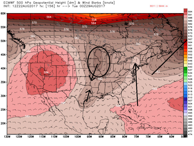
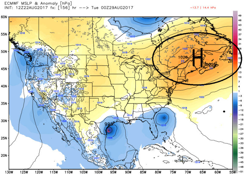
Yeah there is way to much going on in the mid and upper levels to be able to take the 3-5day time frame and beyond seriously. Changes cont to evolve from run to run. Euro is close. Like you said wave spacing currently an issue as modeled. Just a quick look at the euros 12z vs last nights 00z you can see there is more ridge into the NE on the 12z when compared to 00z. Also the trough is exiting a little faster. You can also see by the surface MSLP anomaly map there is HP in control over the NE by the 6-7day. IF, and that's a big IF we see Harvey make landfall and weaken and be drawn N into the digging trough over the mid west, and the center of that trough ends up a little further S of where it is currently modeled as indicated by black arrows, it may pump the ridge further into the NE allowing the trough to exit before picking up what will eventually be Irma sitting of the SE coast effectively cutting Irma off from the mean flow. From there remnants of Harvey and the mean trough in the Mid west, if neutral or neg tilted, would draw Irma further up the coast than is currently modeled. We likely need to see the PNA ridge in the western CONUS trend stronger which at least from 00z to 12z did on the euro. A mean trough in the nations heart land with HP over top in the NE would allow for ventilation of the system which would likely lead to intensification. This would be one way to get the mid west trough to dig a little further S, and possibly result in Irma to make it further N. I'm def not saying it will happen, but I'm certainly not saying it wont at this point either. The GFS has a different H5 set up compared to the Euro but not that dissimilar. As of now modeling conts to show Irma making it no further than OBX before being steered OTS; then ends up doing the fujiwara dance with a cyclone that spins up from energy left behind by the exiting trough out in the N Atlantic at the end of the 12z euro run. The likely reason the NHC has low probability for Irma/92L right now is shear forecasts off the SE coast appear to be moderate at least for the next 2-4 days. Beyond that modeling indicates shear might let up, but that is way to far off. I can almost guarantee the probabilities will start to go back up in about 2-3days if not sooner. I will be going to Denver to do a little partying to celebrate with two of my old high school buddies and our wives. We've known each other for 30yrs or so and all turned 40 this year. Giddy up! I wont be able to do any detailed analysis, but you can be sure Ill comment if things cont to get interesting.
12Z
00z

12Z
_________________
"In weather and in life, there's no winning and losing; there's only winning and learning."
WINTER 2012/2013 TOTALS 43.65"WINTER 2017/2018 TOTALS 62.85" WINTER 2022/2023 TOTALS 4.9"
WINTER 2013/2014 TOTALS 64.85"WINTER 2018/2019 TOTALS 14.25" WINTER 2023/2024 TOTALS 13.1"
WINTER 2014/2015 TOTALS 71.20"WINTER 2019/2020 TOTALS 6.35"
WINTER 2015/2016 TOTALS 35.00"WINTER 2020/2021 TOTALS 37.75"
WINTER 2016/2017 TOTALS 42.25"WINTER 2021/2022 TOTALS 31.65"

sroc4- Admin

- Posts : 8331
Reputation : 301
Join date : 2013-01-07
Location : Wading River, LI
Re: 2017 General Tropical Cyclone Discussion Thread
![]() by rb924119 Tue Aug 22, 2017 4:15 pm
by rb924119 Tue Aug 22, 2017 4:15 pm
rb924119- Meteorologist
- Posts : 6890
Reputation : 194
Join date : 2013-02-06
Age : 32
Location : Greentown, Pa
Re: 2017 General Tropical Cyclone Discussion Thread
![]() by rb924119 Tue Aug 22, 2017 5:21 pm
by rb924119 Tue Aug 22, 2017 5:21 pm
rb924119- Meteorologist
- Posts : 6890
Reputation : 194
Join date : 2013-02-06
Age : 32
Location : Greentown, Pa
Re: 2017 General Tropical Cyclone Discussion Thread
![]() by rb924119 Tue Aug 22, 2017 6:00 pm
by rb924119 Tue Aug 22, 2017 6:00 pm
Something I forgot to add in but wasn't going to cut it again: troughs to the northwest of developing tropical systems tend to aid in development, as does MJO in Phases 2/3. Things to think about in addition to what I highlighted.
https://drive.google.com/open?id=0Byod2Sk27yNYMUJMX3h3NGhXcW8
rb924119- Meteorologist
- Posts : 6890
Reputation : 194
Join date : 2013-02-06
Age : 32
Location : Greentown, Pa
Re: 2017 General Tropical Cyclone Discussion Thread
![]() by mwilli5783 Tue Aug 22, 2017 6:35 pm
by mwilli5783 Tue Aug 22, 2017 6:35 pm
mwilli5783- Posts : 146
Reputation : 9
Join date : 2013-01-23
Age : 69
Location : hempstead n.y
Re: 2017 General Tropical Cyclone Discussion Thread
![]() by algae888 Tue Aug 22, 2017 6:49 pm
by algae888 Tue Aug 22, 2017 6:49 pm
algae888- Advanced Forecaster
- Posts : 5311
Reputation : 46
Join date : 2013-02-05
Age : 61
Location : mt. vernon, new york
Re: 2017 General Tropical Cyclone Discussion Thread
![]() by jmanley32 Wed Aug 23, 2017 1:01 am
by jmanley32 Wed Aug 23, 2017 1:01 am
jmanley32- Senior Enthusiast
- Posts : 20513
Reputation : 108
Join date : 2013-12-12
Age : 42
Location : Yonkers, NY
Re: 2017 General Tropical Cyclone Discussion Thread
![]() by Snow88 Wed Aug 23, 2017 8:39 am
by Snow88 Wed Aug 23, 2017 8:39 am
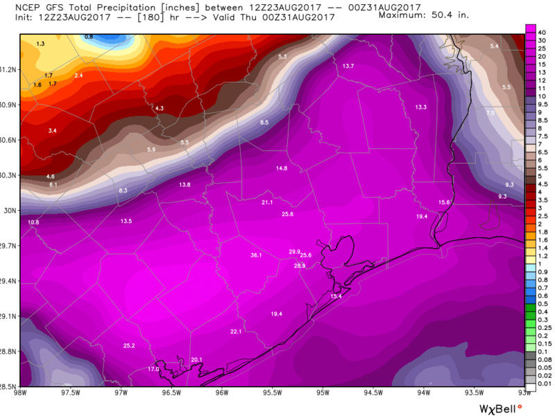
1. Goes OTS
2. Harvey merges with 92 L to give the east coast a fall like rainstorm.
Snow88- Senior Enthusiast
- Posts : 2193
Reputation : 4
Join date : 2013-01-09
Age : 35
Location : Brooklyn, NY
Re: 2017 General Tropical Cyclone Discussion Thread
![]() by sroc4 Wed Aug 23, 2017 1:49 pm
by sroc4 Wed Aug 23, 2017 1:49 pm
Yikes!

_________________
"In weather and in life, there's no winning and losing; there's only winning and learning."
WINTER 2012/2013 TOTALS 43.65"WINTER 2017/2018 TOTALS 62.85" WINTER 2022/2023 TOTALS 4.9"
WINTER 2013/2014 TOTALS 64.85"WINTER 2018/2019 TOTALS 14.25" WINTER 2023/2024 TOTALS 13.1"
WINTER 2014/2015 TOTALS 71.20"WINTER 2019/2020 TOTALS 6.35"
WINTER 2015/2016 TOTALS 35.00"WINTER 2020/2021 TOTALS 37.75"
WINTER 2016/2017 TOTALS 42.25"WINTER 2021/2022 TOTALS 31.65"
sroc4- Admin
- Posts : 8331
Reputation : 301
Join date : 2013-01-07
Location : Wading River, LI
Re: 2017 General Tropical Cyclone Discussion Thread
![]() by amugs Wed Aug 23, 2017 4:22 pm
by amugs Wed Aug 23, 2017 4:22 pm

_________________
Mugs
AKA:King: Snow Weenie
Self Proclaimed
WINTER 2014-15 : 55.12" +.02 for 6 coatings (avg. 35")
WINTER 2015-16 Total - 29.8" (Avg 35")
WINTER 2016-17 : 39.5" so far

amugs- Advanced Forecaster - Mod

- Posts : 15093
Reputation : 213
Join date : 2013-01-07
Age : 54
Location : Hillsdale,NJ
Re: 2017 General Tropical Cyclone Discussion Thread
![]() by amugs Wed Aug 23, 2017 4:43 pm
by amugs Wed Aug 23, 2017 4:43 pm
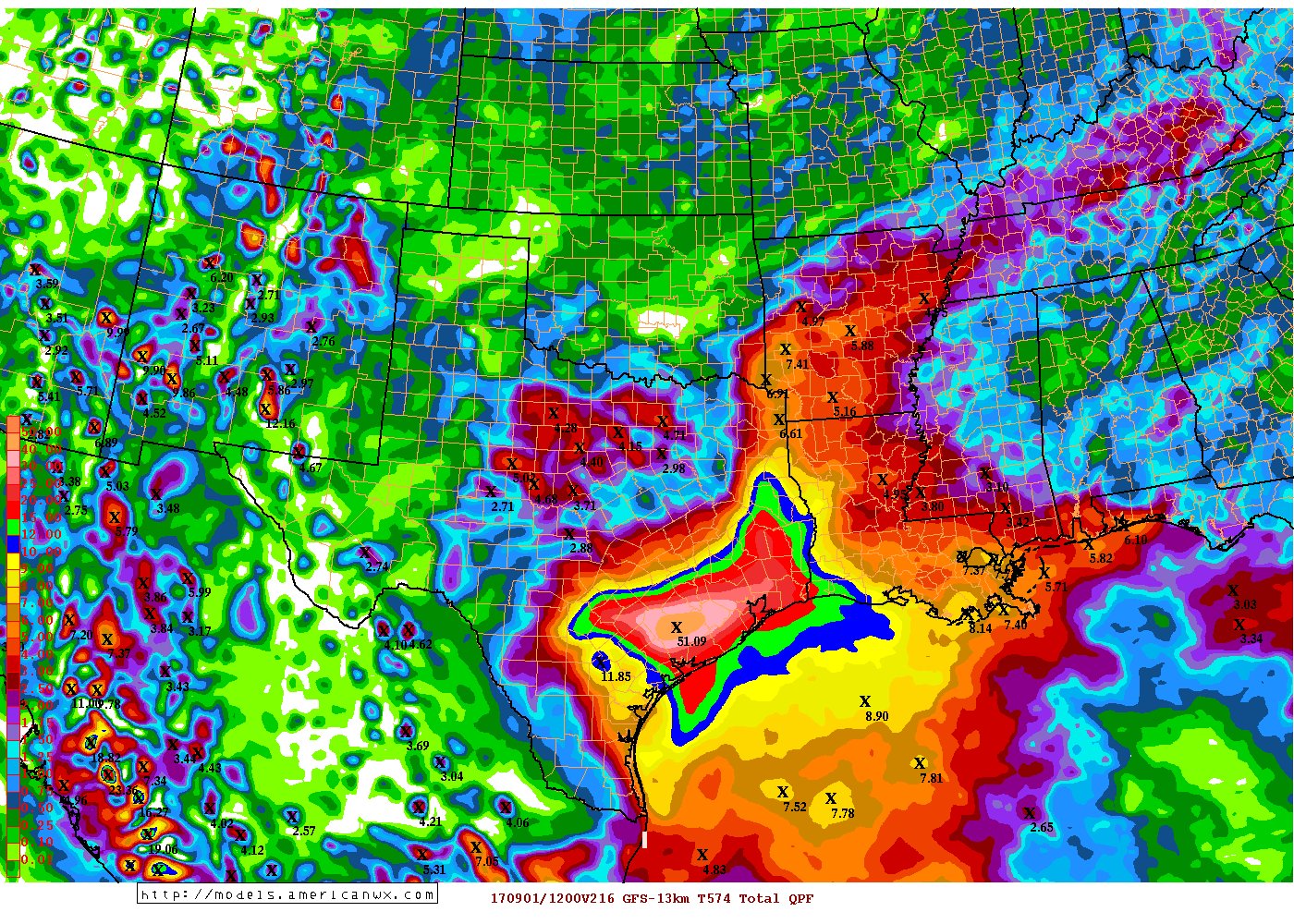
Get out the Ark peeps - 9 day total of 51" JESUS!!!
_________________
Mugs
AKA:King: Snow Weenie
Self Proclaimed
WINTER 2014-15 : 55.12" +.02 for 6 coatings (avg. 35")
WINTER 2015-16 Total - 29.8" (Avg 35")
WINTER 2016-17 : 39.5" so far
amugs- Advanced Forecaster - Mod
- Posts : 15093
Reputation : 213
Join date : 2013-01-07
Age : 54
Location : Hillsdale,NJ
Re: 2017 General Tropical Cyclone Discussion Thread
![]() by skinsfan1177 Wed Aug 23, 2017 5:14 pm
by skinsfan1177 Wed Aug 23, 2017 5:14 pm


skinsfan1177- Senior Enthusiast
- Posts : 4485
Reputation : 35
Join date : 2013-01-07
Age : 46
Location : Point Pleasant Boro
Page 12 of 40 • 1 ... 7 ... 11, 12, 13 ... 26 ... 40 ![]()
|
|
|