
 Search
Long Range Thread 15.0
Page 26 of 42 •  1 ... 14 ... 25, 26, 27 ... 34 ... 42
 ![]()
Re: Long Range Thread 15.0
![]() by jmanley32 Wed Dec 20, 2017 4:04 pm
by jmanley32 Wed Dec 20, 2017 4:04 pm
Nice system but need that well offshore to give the coast and even inland a shot at all snow. Could it happen of course, thats the trend.rb924119 wrote:amugs wrote:rb924119 wrote:Huge changes aloft versus 00z, and we continue trending in the right direction.
Rb
We have the "full court press" starting to wear down the mdoels ENS and OP's today - for example teh GFS went from a cutter into Detroit to one up into the apps spine now.
By tomorrow 12 Z we should see another tick or two SE.
The wave break and anomalous ridge be built in the NPAC is going to be incredible one we will long for after the 1-10ish time frame IMO
See teh buckle in teh JET off the West coast ? Follow the purple color and how it goes North like a rollercoaster - it i getting deeper/stronger as we approach its time for it to be there.
WOW EURO HOLY SHT!!
To you and Frank, THIS is why I have been using the caps Ahahaha this pattern has me FIRED UP THROUGH THE NEW YEAR. And now we got a double "Maddone" from Scott and Frank!!!! YEAHHHHHHHHHHHHHH BUDDYYYYYYYY!!!!!!!

.png)
jmanley32- Senior Enthusiast

- Posts : 20517
Join date : 2013-12-12
Re: Long Range Thread 15.0
![]() by SnowForest Wed Dec 20, 2017 4:16 pm
by SnowForest Wed Dec 20, 2017 4:16 pm
amugs wrote:rb924119 wrote:Huge changes aloft versus 00z, and we continue trending in the right direction.
Rb
We have the "full court press" starting to wear down the mdoels ENS and OP's today - for example teh GFS went from a cutter into Detroit to one up into the apps spine now.
By tomorrow 12 Z we should see another tick or two SE.
The wave break and anomalous ridge be built in the NPAC is going to be incredible one we will long for after the 1-10ish time frame IMO
See teh buckle in teh JET off the West coast ? Follow the purple color and how it goes North like a rollercoaster - it i getting deeper/stronger as we approach its time for it to be there.
WOW EURO HOLY SHT!!
Would this mean multiple snow chances for coast, or rain to snow?
SnowForest- Posts : 36
Join date : 2017-12-19
Re: Long Range Thread 15.0
![]() by Armando Salvadore Wed Dec 20, 2017 7:54 pm
by Armando Salvadore Wed Dec 20, 2017 7:54 pm

Armando Salvadore- Advanced Forecaster

- Posts : 171
Reputation : 0
Join date : 2016-12-23
Location : Springfield, NJ
Re: Long Range Thread 15.0
![]() by track17 Wed Dec 20, 2017 9:29 pm
by track17 Wed Dec 20, 2017 9:29 pm
track17- Posts : 454
Reputation : 4
Join date : 2016-01-09
Re: Long Range Thread 15.0
![]() by mikeypizano Wed Dec 20, 2017 9:34 pm
by mikeypizano Wed Dec 20, 2017 9:34 pm
track17 wrote:I don't like that everyone is so quiet has me worried the new runs were not good. Or are things still trending well
Me either, but your welcome to send me a text, number is in my signature

mikeypizano- Pro Enthusiast

- Posts : 1118
Reputation : 66
Join date : 2017-01-05
Age : 35
Location : Wilkes-Barre/Scranton, PA
Re: Long Range Thread 15.0
![]() by MattyICE Wed Dec 20, 2017 9:47 pm
by MattyICE Wed Dec 20, 2017 9:47 pm
MattyICE- Advanced Forecaster
- Posts : 249
Reputation : 6
Join date : 2017-11-10
Age : 38
Location : Clifton, NJ (Eastern Passaic County)
Re: Long Range Thread 15.0
![]() by rb924119 Wed Dec 20, 2017 10:04 pm
by rb924119 Wed Dec 20, 2017 10:04 pm
rb924119- Meteorologist

- Posts : 6890
Reputation : 194
Join date : 2013-02-06
Age : 32
Location : Greentown, Pa
Re: Long Range Thread 15.0
![]() by Guest Wed Dec 20, 2017 10:17 pm
by Guest Wed Dec 20, 2017 10:17 pm
mikeypizano wrote:track17 wrote:I don't like that everyone is so quiet has me worried the new runs were not good. Or are things still trending well
Me either, but your welcome to send me a text, number is in my signature
Rookies. It took me awhile to learn this truth also. The forum is busy in the evenings about 10 pm once the models start running which is about every 6 hours. Or it’s busy all day 24 hours before the storm and during it
Guest- Guest
Re: Long Range Thread 15.0
![]() by jmanley32 Thu Dec 21, 2017 12:23 am
by jmanley32 Thu Dec 21, 2017 12:23 am

jmanley32- Senior Enthusiast
- Posts : 20517
Reputation : 108
Join date : 2013-12-12
Age : 42
Location : Yonkers, NY
Re: Long Range Thread 15.0
![]() by frank 638 Thu Dec 21, 2017 4:30 am
by frank 638 Thu Dec 21, 2017 4:30 am
frank 638- Senior Enthusiast
- Posts : 2825
Reputation : 37
Join date : 2016-01-01
Age : 40
Location : bronx ny
Re: Long Range Thread 15.0
![]() by rb924119 Thu Dec 21, 2017 4:33 am
by rb924119 Thu Dec 21, 2017 4:33 am
rb924119- Meteorologist
- Posts : 6890
Reputation : 194
Join date : 2013-02-06
Age : 32
Location : Greentown, Pa
Re: Long Range Thread 15.0
![]() by rb924119 Thu Dec 21, 2017 4:38 am
by rb924119 Thu Dec 21, 2017 4:38 am
rb924119- Meteorologist
- Posts : 6890
Reputation : 194
Join date : 2013-02-06
Age : 32
Location : Greentown, Pa

skinsfan1177- Senior Enthusiast
- Posts : 4485
Reputation : 35
Join date : 2013-01-07
Age : 46
Location : Point Pleasant Boro
Re: Long Range Thread 15.0
![]() by frank 638 Thu Dec 21, 2017 5:16 am
by frank 638 Thu Dec 21, 2017 5:16 am
frank 638- Senior Enthusiast
- Posts : 2825
Reputation : 37
Join date : 2016-01-01
Age : 40
Location : bronx ny
Re: Long Range Thread 15.0
![]() by nutleyblizzard Thu Dec 21, 2017 6:14 am
by nutleyblizzard Thu Dec 21, 2017 6:14 am

nutleyblizzard- Senior Enthusiast
- Posts : 1952
Reputation : 41
Join date : 2014-01-30
Age : 58
Location : Nutley, new jersey
Re: Long Range Thread 15.0
![]() by sroc4 Thu Dec 21, 2017 6:34 am
by sroc4 Thu Dec 21, 2017 6:34 am

_________________
"In weather and in life, there's no winning and losing; there's only winning and learning."
WINTER 2012/2013 TOTALS 43.65"WINTER 2017/2018 TOTALS 62.85" WINTER 2022/2023 TOTALS 4.9"
WINTER 2013/2014 TOTALS 64.85"WINTER 2018/2019 TOTALS 14.25" WINTER 2023/2024 TOTALS 13.1"
WINTER 2014/2015 TOTALS 71.20"WINTER 2019/2020 TOTALS 6.35"
WINTER 2015/2016 TOTALS 35.00"WINTER 2020/2021 TOTALS 37.75"
WINTER 2016/2017 TOTALS 42.25"WINTER 2021/2022 TOTALS 31.65"

sroc4- Admin

- Posts : 8331
Reputation : 301
Join date : 2013-01-07
Location : Wading River, LI
Re: Long Range Thread 15.0
![]() by skinsfan1177 Thu Dec 21, 2017 6:39 am
by skinsfan1177 Thu Dec 21, 2017 6:39 am
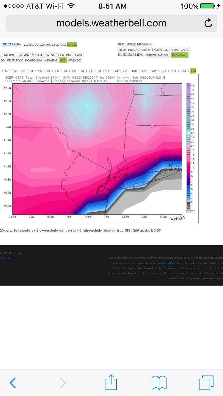
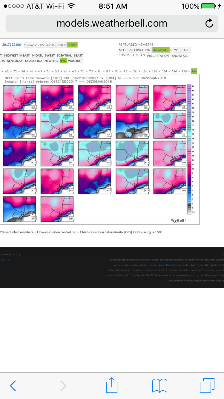
nutleyblizzard wrote:6z GFS has a HECS for later next week. All models now on board for a major to historic snow event!
I never like being in the bullseye so far out
skinsfan1177- Senior Enthusiast
- Posts : 4485
Reputation : 35
Join date : 2013-01-07
Age : 46
Location : Point Pleasant Boro
Re: Long Range Thread 15.0
![]() by hyde345 Thu Dec 21, 2017 6:45 am
by hyde345 Thu Dec 21, 2017 6:45 am
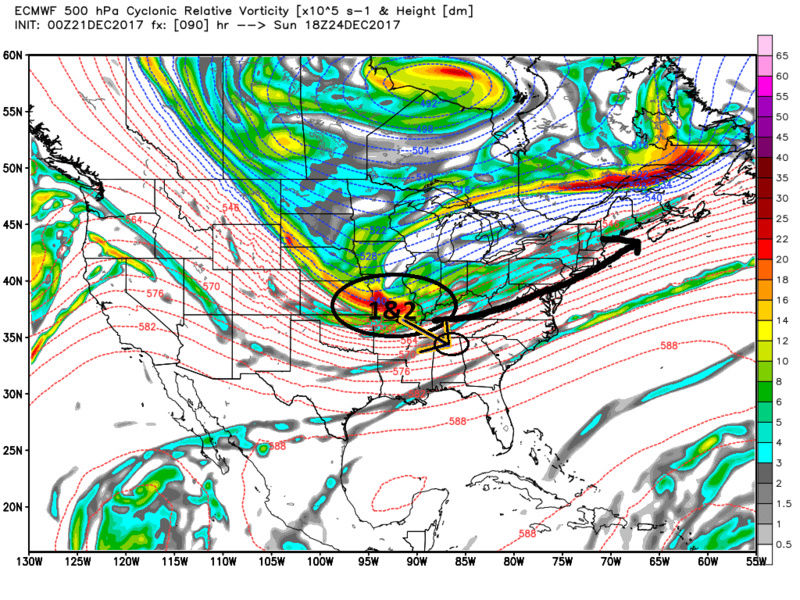
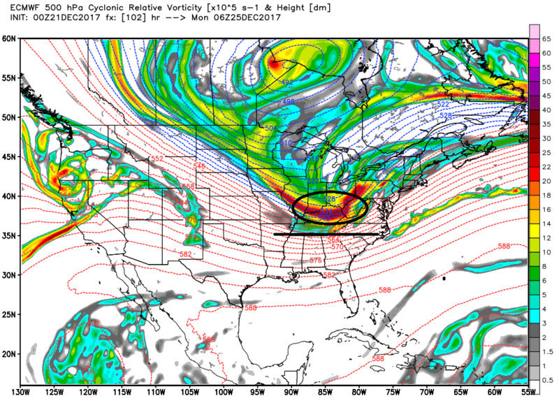
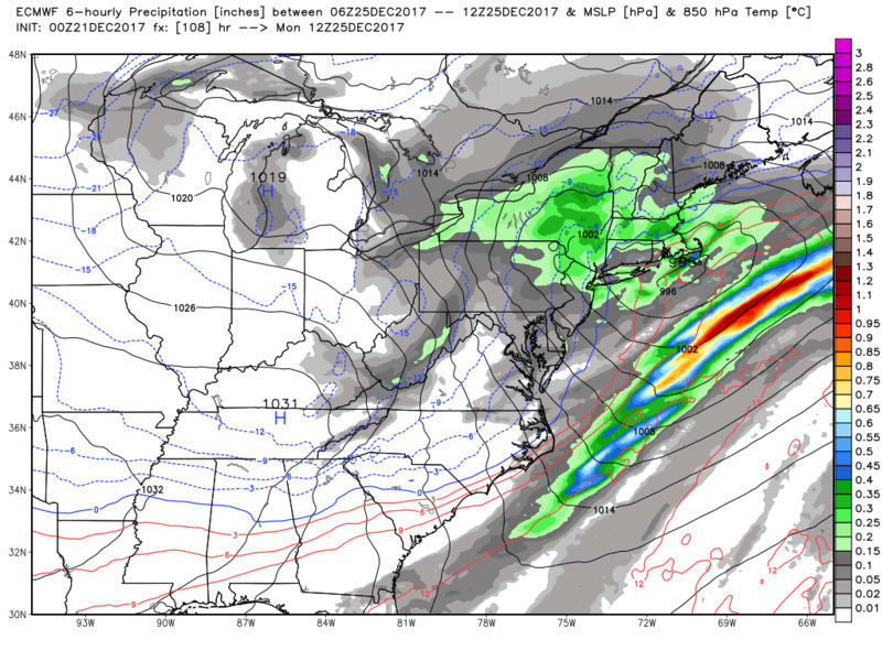
A potent PV anomaly will round through the digging upper long wave
trough through Sunday into Sunday evening. This feature, along with
the eventual position of the Hudson Bay low, will dictate if/where
this coastal storm develops. The best baroclinicity will be near
the I95 corridor with surface pressures beginning to drop as
entrance region dynamics assist with low pressure wave developing
along this baroclinic zone. The ECMWF and GGEM suggest this wave
will develop just east of the mid-Atlantic coastline as
strengthening upper jet approaches 170kts. The ECMWF points toward
rapidly intensifying cyclone through Christmas Day with bomb-
cyclogenesis through the Gulf of Maine. Combination of deformation
and fgen, seems we could be in for a moderate to heavy snowfall.
However, can not completely rule out the GFS as it too remains
constant with its previous runs and ensemble mean. Stay tuned...

hyde345- Pro Enthusiast
- Posts : 1082
Reputation : 48
Join date : 2013-01-08
Location : Hyde Park, NY
Re: Long Range Thread 15.0
![]() by jmanley32 Thu Dec 21, 2017 6:46 am
by jmanley32 Thu Dec 21, 2017 6:46 am
jmanley32- Senior Enthusiast
- Posts : 20517
Reputation : 108
Join date : 2013-12-12
Age : 42
Location : Yonkers, NY
Re: Long Range Thread 15.0
![]() by docstox12 Thu Dec 21, 2017 6:58 am
by docstox12 Thu Dec 21, 2017 6:58 am

docstox12- Wx Statistician Guru

- Posts : 8507
Reputation : 222
Join date : 2013-01-07
Age : 73
Location : Monroe NY
Re: Long Range Thread 15.0
![]() by CPcantmeasuresnow Thu Dec 21, 2017 7:23 am
by CPcantmeasuresnow Thu Dec 21, 2017 7:23 am
nutleyblizzard wrote:6z GFS has a HECS for later next week. All models now on board for a major to historic snow event!
Historic may be a little strong.
NYC which is usually on the low end snowfall wise of our major storms has had 6 storms of 19 inches or more in just the last 14 years an average of one almost every 2 years. Our area has seen at least a dozen storms in that period where a significant portion of our area saw 20 plus inches, 30 plus in many spots. In that context historic would have to be something 30 plus area wide and I don't think we're looking at anything like that.
I'd love to be wrong though.

CPcantmeasuresnow- Wx Statistician Guru
- Posts : 7274
Reputation : 230
Join date : 2013-01-07
Age : 103
Location : Eastern Orange County, NY
Re: Long Range Thread 15.0
![]() by jmanley32 Thu Dec 21, 2017 7:35 am
by jmanley32 Thu Dec 21, 2017 7:35 am
Well thats exactly what the models are showing area wide, but its 10 days out so either could be wrong, but i do hope your wrong : )CPcantmeasuresnow wrote:nutleyblizzard wrote:6z GFS has a HECS for later next week. All models now on board for a major to historic snow event!
Historic may be a little strong.
NYC which is usually on the low end snowfall wise of our major storms has had 6 storms of 19 inches or more in just the last 14 years an average of one almost every 2 years. Our area has seen at least a dozen storms in that period where a significant portion of our area saw 20 plus inches, 30 plus in many spots. In that context historic would have to be something 30 plus area wide and I don't think we're looking at anything like that.
I'd love to be wrong though.
jmanley32- Senior Enthusiast
- Posts : 20517
Reputation : 108
Join date : 2013-12-12
Age : 42
Location : Yonkers, NY
Re: Long Range Thread 15.0
![]() by hyde345 Thu Dec 21, 2017 7:47 am
by hyde345 Thu Dec 21, 2017 7:47 am
hyde345- Pro Enthusiast
- Posts : 1082
Reputation : 48
Join date : 2013-01-08
Location : Hyde Park, NY
Re: Long Range Thread 15.0
![]() by sroc4 Thu Dec 21, 2017 7:51 am
by sroc4 Thu Dec 21, 2017 7:51 am
_________________
"In weather and in life, there's no winning and losing; there's only winning and learning."
WINTER 2012/2013 TOTALS 43.65"WINTER 2017/2018 TOTALS 62.85" WINTER 2022/2023 TOTALS 4.9"
WINTER 2013/2014 TOTALS 64.85"WINTER 2018/2019 TOTALS 14.25" WINTER 2023/2024 TOTALS 13.1"
WINTER 2014/2015 TOTALS 71.20"WINTER 2019/2020 TOTALS 6.35"
WINTER 2015/2016 TOTALS 35.00"WINTER 2020/2021 TOTALS 37.75"
WINTER 2016/2017 TOTALS 42.25"WINTER 2021/2022 TOTALS 31.65"
sroc4- Admin
- Posts : 8331
Reputation : 301
Join date : 2013-01-07
Location : Wading River, LI
Re: Long Range Thread 15.0
![]() by sroc4 Thu Dec 21, 2017 8:01 am
by sroc4 Thu Dec 21, 2017 8:01 am


_________________
"In weather and in life, there's no winning and losing; there's only winning and learning."
WINTER 2012/2013 TOTALS 43.65"WINTER 2017/2018 TOTALS 62.85" WINTER 2022/2023 TOTALS 4.9"
WINTER 2013/2014 TOTALS 64.85"WINTER 2018/2019 TOTALS 14.25" WINTER 2023/2024 TOTALS 13.1"
WINTER 2014/2015 TOTALS 71.20"WINTER 2019/2020 TOTALS 6.35"
WINTER 2015/2016 TOTALS 35.00"WINTER 2020/2021 TOTALS 37.75"
WINTER 2016/2017 TOTALS 42.25"WINTER 2021/2022 TOTALS 31.65"
sroc4- Admin
- Posts : 8331
Reputation : 301
Join date : 2013-01-07
Location : Wading River, LI
Re: Long Range Thread 15.0
![]() by Guest Thu Dec 21, 2017 8:45 am
by Guest Thu Dec 21, 2017 8:45 am
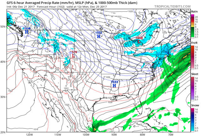
Sunday Night A chance of rain before midnight, then rain and sleet likely between midnight and 3am, then rain, snow, and sleet likely after 3am. Mostly cloudy, with a low around 32. Chance of precipitation is 70%.
Christmas DayA chance of snow showers, mixing with rain after 7am, then gradually ending. Partly sunny, with a high near 42. Breezy. Chance of precipitation is 40%.
Guest- Guest
Re: Long Range Thread 15.0
![]() by rb924119 Thu Dec 21, 2017 8:52 am
by rb924119 Thu Dec 21, 2017 8:52 am
rb924119- Meteorologist
- Posts : 6890
Reputation : 194
Join date : 2013-02-06
Age : 32
Location : Greentown, Pa
Page 26 of 42 • 1 ... 14 ... 25, 26, 27 ... 34 ... 42 ![]()
|
|
|