Long Range Thread 18.0
+48
Roger92
Quietace
GreyBeard
mmanisca
oldtimer
Dunnzoo
Irish
snowday111
brownie
Grselig
Zhukov1945
Snow88
crippo84
bobjohnsonforthehall
Scullybutcher
dkodgis
Smitty623
snowlover 12345
heehaw453
dsix85
jimv45
Math23x7
sroc4
aiannone
Vinnydula
Sanchize06
SENJsnowman
emokid51783
HectorO
lglickman1
Carvin
nutleyblizzard
SoulSingMG
hyde345
docstox12
amugs
algae888
Radz
CPcantmeasuresnow
skinsfan1177
billg315
rb924119
weatherwatchermom
mwilli5783
jmanley32
adamfitz1969
frank 638
Frank_Wx
52 posters
Page 1 of 36
Page 1 of 36 • 1, 2, 3 ... 18 ... 36 
 Long Range Thread 18.0
Let's get down to some business.
In the prior long range thread its been mentioned the pattern is showing signs of undergoing significant changes. While you have heard this already once before (regrettably from my "ferocious" New Year thread), and you may feel hesitation, I am feeling pretty confident this time around.
Here is a look at the 500mb pattern valid Thursdaythis week.

That huge area of red, or ridging, northeast of Alaska is the #1 reason why we have something to talk about for next weekend. I've already mentioned this feature in the prior thread. The -EPO ridge promotes higher heights (or warmer temps) across western Canada into the Arctic region. As this region of the world warms up, the eastern U.S. cools down because the Polar Vortex is forced out of the Arctic (-AO) and into Canada resulting in a trough over the eastern third of the U.S.
Advancing to Saturday evening next weekend...

The -EPO ridge remains and check out what's found over the Gulf coast. A trough. Within this trough is pieces of energy getting ready to develop a storm system that could potentially come up the coast. Look how there is red, or higher heights, along the east coast. This indicates the storm has a "path" to follow toward the Benchmark instead of trying to escape out to sea. The reason being the -EPO/+PNA allowing for storm systems to pivot northward instead of scooting away out to sea.
A closer look at next weekend's set-up can be seen on the 500mb vort graphs

On Saturday afternoon you can see the GFS is advertising a big +PNA spike (ridge) in the western U.S., with polar energy (northern stream energy) diving south into the trough found near the Gulf Coast. The trough at this juncture is positively tilted. Ideally we want to see a neutral trough tilting negative at this stage. What you will also notice is the upper air energy is strung out from the Gulf coast all the way up to the Ohio Valley. This looks like the makings of a fast moving cold front more than it does a big coastal storm. The thermal gradient in northern New England is impressive, and that will help to make sure there is cold air to work with.

As we move forward to Sunday night the ridge in the western U.S. collapses and the flow across the U.S. turns progressive. While a phase did occur and a coastal storm did form on the GFS, it traveled out to sea because of how poor the pattern is upstream near the Pacific. Atlantic blocking (-NAO) would help here, and there actually is signs of a weak to moderate -NAO, but it formed too late on this run verbatim.
Next weekend is by far our best threat of the winter to this point. But I actually do not want to hone in on just this threat, because the overall pattern beginning the week of 21st is look VERY conducive for a Godzilla-type storm. While next weekend's threat could produce a Godzilla, I prefer the pattern I am seeing beyond the 21st because the Pacific jet stream is shown to retract which gives space for the PNA ridge to form and actually stay there, instead of trying to roll forward which disrupts the entire flow downstream.
It is also going to get frigid. We're looking at temps in the 20's and teens during the day and near zero (or below N&W) at night. So, while we have something to track next weekend, I think we will have A LOT more to track beyond the 21st into February where the pattern will be ripe.
In the prior long range thread its been mentioned the pattern is showing signs of undergoing significant changes. While you have heard this already once before (regrettably from my "ferocious" New Year thread), and you may feel hesitation, I am feeling pretty confident this time around.
Here is a look at the 500mb pattern valid Thursdaythis week.

That huge area of red, or ridging, northeast of Alaska is the #1 reason why we have something to talk about for next weekend. I've already mentioned this feature in the prior thread. The -EPO ridge promotes higher heights (or warmer temps) across western Canada into the Arctic region. As this region of the world warms up, the eastern U.S. cools down because the Polar Vortex is forced out of the Arctic (-AO) and into Canada resulting in a trough over the eastern third of the U.S.
Advancing to Saturday evening next weekend...

The -EPO ridge remains and check out what's found over the Gulf coast. A trough. Within this trough is pieces of energy getting ready to develop a storm system that could potentially come up the coast. Look how there is red, or higher heights, along the east coast. This indicates the storm has a "path" to follow toward the Benchmark instead of trying to escape out to sea. The reason being the -EPO/+PNA allowing for storm systems to pivot northward instead of scooting away out to sea.
A closer look at next weekend's set-up can be seen on the 500mb vort graphs

On Saturday afternoon you can see the GFS is advertising a big +PNA spike (ridge) in the western U.S., with polar energy (northern stream energy) diving south into the trough found near the Gulf Coast. The trough at this juncture is positively tilted. Ideally we want to see a neutral trough tilting negative at this stage. What you will also notice is the upper air energy is strung out from the Gulf coast all the way up to the Ohio Valley. This looks like the makings of a fast moving cold front more than it does a big coastal storm. The thermal gradient in northern New England is impressive, and that will help to make sure there is cold air to work with.

As we move forward to Sunday night the ridge in the western U.S. collapses and the flow across the U.S. turns progressive. While a phase did occur and a coastal storm did form on the GFS, it traveled out to sea because of how poor the pattern is upstream near the Pacific. Atlantic blocking (-NAO) would help here, and there actually is signs of a weak to moderate -NAO, but it formed too late on this run verbatim.
Next weekend is by far our best threat of the winter to this point. But I actually do not want to hone in on just this threat, because the overall pattern beginning the week of 21st is look VERY conducive for a Godzilla-type storm. While next weekend's threat could produce a Godzilla, I prefer the pattern I am seeing beyond the 21st because the Pacific jet stream is shown to retract which gives space for the PNA ridge to form and actually stay there, instead of trying to roll forward which disrupts the entire flow downstream.
It is also going to get frigid. We're looking at temps in the 20's and teens during the day and near zero (or below N&W) at night. So, while we have something to track next weekend, I think we will have A LOT more to track beyond the 21st into February where the pattern will be ripe.
_________________
_______________________________________________________________________________________________________
CLICK HERE to view NJ Strong Snowstorm Classifications
 Re: Long Range Thread 18.0
Thank you Frank for the update we are ready to go it's time that we all get a good snow storm 4 the whole area
frank 638- Senior Enthusiast

- Posts : 2824
Reputation : 37
Join date : 2016-01-01
Age : 40
Location : bronx ny
adamfitz1969- Posts : 122
Reputation : 14
Join date : 2018-03-01
Age : 54
Location : Tarrytown
 Re: Long Range Thread 18.0
Thanks for the update so in other words your not that enthused about a threat again but this one has a bit more promise? Seems par for the course Rb guess your not get your m word.

jmanley32- Senior Enthusiast

- Posts : 20513
Reputation : 108
Join date : 2013-12-12
Age : 42
Location : Yonkers, NY
 Re: Long Range Thread 18.0
frank..thanks for the info keeping fingers crossed,on "the big one"
mwilli5783- Posts : 146
Reputation : 9
Join date : 2013-01-23
Age : 69
Location : hempstead n.y
 Re: Long Range Thread 18.0
If that happens I will pull a scott and jump in the snow in my skivies lol (something done years ago before many of you).adamfitz1969 wrote:

jmanley32- Senior Enthusiast

- Posts : 20513
Reputation : 108
Join date : 2013-12-12
Age : 42
Location : Yonkers, NY
 Re: Long Range Thread 18.0
Thank you Frank! At least there are some opportunities on the horizon! Ps..cute pup!!

weatherwatchermom- Senior Enthusiast

- Posts : 3734
Reputation : 77
Join date : 2014-11-25
Age : 60
Location : Hazlet Township, NJ
 Re: Long Range Thread 18.0
jmanley32 wrote:Thanks for the update so in other words your not that enthused about a threat again but this one has a bit more promise? Seems par for the course Rb guess your not get your m word.
I'm enthused about a complete pattern change from the 20th into February. I think the storm threat next weekend is our best one yet, but I'm not too enthused about it yet.
_________________
_______________________________________________________________________________________________________
CLICK HERE to view NJ Strong Snowstorm Classifications
 Re: Long Range Thread 18.0
Frank, excellent discussion, and it will tie in beautifully with mine when I get it together. Just one question: CAN YOU USE THE “M” WORD NOW AFTER TONIGHTS RUNS?????? Lol
rb924119- Meteorologist

- Posts : 6889
Reputation : 194
Join date : 2013-02-06
Age : 32
Location : Greentown, Pa
 Re: Long Range Thread 18.0
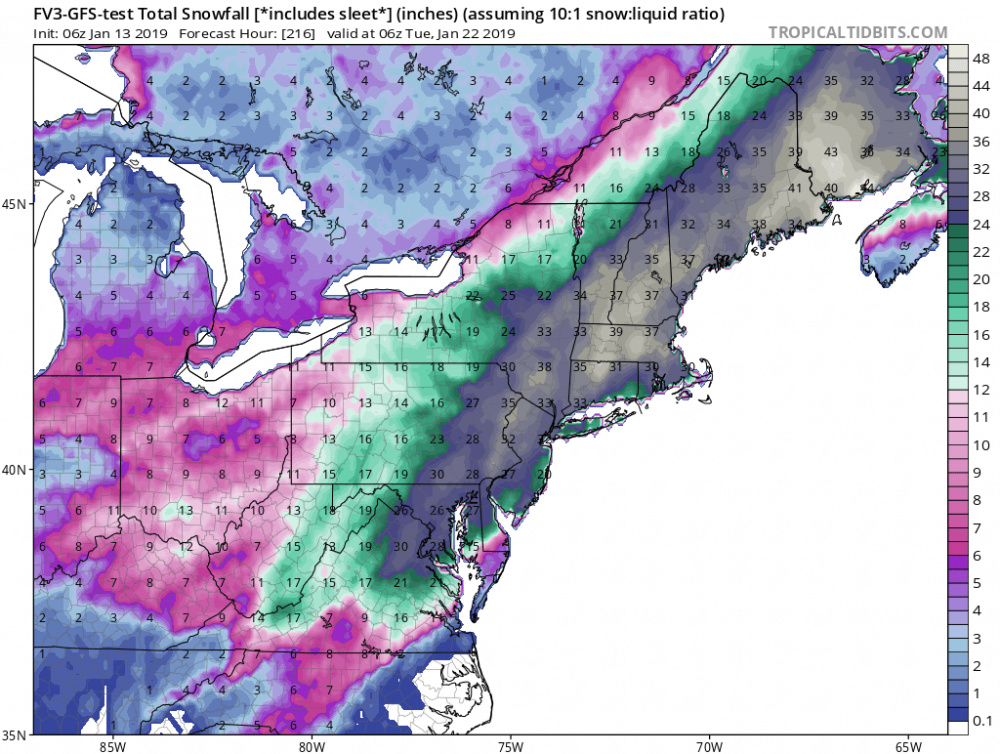
Not su r e what looked so great about the runs tonight I know surface is misleading but they were all rainstorms except far interior and front like systems. Can't wait to read your write up cuz I'm not totally getting the e citement. Btw I read that map posted above is like the mother of end all ice storms most is not snow but many inches of ice yikes!

jmanley32- Senior Enthusiast

- Posts : 20513
Reputation : 108
Join date : 2013-12-12
Age : 42
Location : Yonkers, NY
 Re: Long Range Thread 18.0
jmanley32 wrote:Not su r e what looked so great about the runs tonight I know surface is misleading but they were all rainstorms except far interior and front like systems. Can't wait to read your write up cuz I'm not totally getting the e citement. Btw I read that map posted above is like the mother of end all ice storms most is not snow but many inches of ice yikes!
I’ll let somebody else post the maps lol
rb924119- Meteorologist

- Posts : 6889
Reputation : 194
Join date : 2013-02-06
Age : 32
Location : Greentown, Pa
 Re: Long Range Thread 18.0
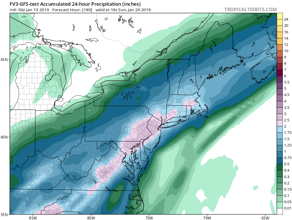
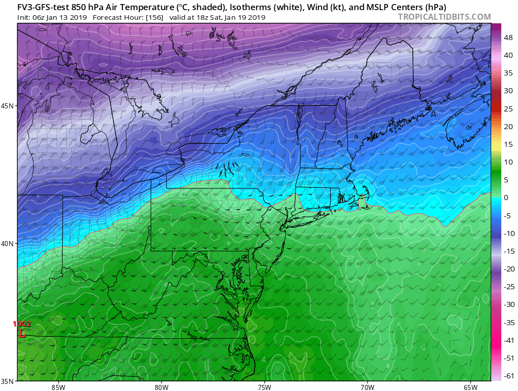
I saw the maps, but it looks like unless you are from the central NY area north its rain, with the exception of the FV3 which has the worst ice storm I have ever seen, 30 some odd inches of sleet and frz....that cant happen right?rb924119 wrote:jmanley32 wrote:Not su r e what looked so great about the runs tonight I know surface is misleading but they were all rainstorms except far interior and front like systems. Can't wait to read your write up cuz I'm not totally getting the e citement. Btw I read that map posted above is like the mother of end all ice storms most is not snow but many inches of ice yikes!
I’ll let somebody else post the maps lol
Okay didnt see the Euro, wow...It gets the warm layer very close or along the coast but the snow map still pumps out a godzilla for everyone from here to kingdom come, wide area huge impact on that run.

jmanley32- Senior Enthusiast

- Posts : 20513
Reputation : 108
Join date : 2013-12-12
Age : 42
Location : Yonkers, NY

jmanley32- Senior Enthusiast

- Posts : 20513
Reputation : 108
Join date : 2013-12-12
Age : 42
Location : Yonkers, NY
 Re: Long Range Thread 18.0
Yeah, this, we do not need. Inch and a half of ice accretion? No thank you. Lol. Hopefully this changes as we get closer (although GFS yesterday had a prolonged ice event too).

billg315- Advanced Forecaster - Mod

- Posts : 4462
Reputation : 185
Join date : 2015-01-24
Age : 50
Location : Flemington, NJ

skinsfan1177- Senior Enthusiast

- Posts : 4485
Reputation : 35
Join date : 2013-01-07
Age : 46
Location : Point Pleasant Boro

CPcantmeasuresnow- Wx Statistician Guru

- Posts : 7274
Reputation : 230
Join date : 2013-01-07
Age : 103
Location : Eastern Orange County, NY
 Re: Long Range Thread 18.0
Thanks for the education. I just looked at the snow map above my post and thought Snowmageddon was coming. Although even if this map verified as all snow for my area, it would still fall short of Superstorm '93.
Guest- Guest
 Re: Long Range Thread 18.0
All 3 globals continue to show a potent storm for next weekend, yet the evolution of the event is changing somewhat- yesterday it looked more like the first wave came through with the arctic front, and then a second wave developed along the front and dropped copious amounts of Qpf with the GOM feed right up the coast...
Radz- Pro Enthusiast

- Posts : 1028
Reputation : 17
Join date : 2013-01-12
Location : Cortlandt Manor NY
 Re: Long Range Thread 18.0
MY weather channel app, never that reliable but sometimes telling, has 12-21 inches of snow for Orange County next Saturday and Sunday. For three days now it's shown consistently 9-16 and now 12-21. It's seeing something as are all the models at this far out juncture. A lot of model runs between now and next weekend.

CPcantmeasuresnow- Wx Statistician Guru

- Posts : 7274
Reputation : 230
Join date : 2013-01-07
Age : 103
Location : Eastern Orange County, NY
 Re: Long Range Thread 18.0
Yup, the app has the snow icons since yesterday morning - just playing off the model runs... and temps Tuesday morning following the storm look to be the coldest thus far this season... trying to temper my enthusiasm, but after this horrible snow drought, I'm already glued to the signs of the pattern evolution...

Radz- Pro Enthusiast

- Posts : 1028
Reputation : 17
Join date : 2013-01-12
Location : Cortlandt Manor NY

jmanley32- Senior Enthusiast

- Posts : 20513
Reputation : 108
Join date : 2013-12-12
Age : 42
Location : Yonkers, NY
 Re: Long Range Thread 18.0
I hope this trends colder cuz the temps are to high not just along coast but pretty far inland too. If the fv3 played put it would be a crippling ice storm for 95 corridor and about 50 to 75 miles inland.

jmanley32- Senior Enthusiast

- Posts : 20513
Reputation : 108
Join date : 2013-12-12
Age : 42
Location : Yonkers, NY
 Re: Long Range Thread 18.0
I wouldn't get very excited about next weekend system it looks more like a cold frontal passage with waves of low pressure riding along it. Where the boundary sets up is too early to tell probably wouldn't know till Thursday for sure but don't look for anything big from this but it definitely can drop some snow as Frank says the pattern really gets ripe after this one when we have blocking over Greenland and the Pacific finally slows down

algae888- Advanced Forecaster

- Posts : 5311
Reputation : 46
Join date : 2013-02-05
Age : 61
Location : mt. vernon, new york
 Re: Long Range Thread 18.0
algae888 wrote:I wouldn't get very excited about next weekend system it looks more like a cold frontal passage with waves of low pressure riding along it. Where the boundary sets up is too early to tell probably wouldn't know till Thursday for sure but don't look for anything big from this but it definitely can drop some snow as Frank says the pattern really gets ripe after this one when we have blocking over Greenland and the Pacific finally slows down
Respectfully disagree, Al
rb924119- Meteorologist

- Posts : 6889
Reputation : 194
Join date : 2013-02-06
Age : 32
Location : Greentown, Pa
Page 1 of 36 • 1, 2, 3 ... 18 ... 36 
Page 1 of 36
Permissions in this forum:
You cannot reply to topics in this forum
 Home
Home


