
 Search
Long Range Thread 18.0
Page 21 of 36 •  1 ... 12 ... 20, 21, 22 ... 28 ... 36
 ![]()
Re: Long Range Thread 18.0
![]() by sroc4 Fri Feb 01, 2019 12:45 pm
by sroc4 Fri Feb 01, 2019 12:45 pm
syosnow94 wrote: Scott I copied and pasted This from your post
Moving forward I ask that we stop arguing semantics about the pattern. It has changed, and our odds of snow have dramatically increased. Unfort despite the increased odds it hasn't paid off for most due to the aforementioned MJO reason. IF or WHEN the MJO decreases in amplitude and/or it moves into more favorable phases that resistance to our east relaxes and our storm track should shift east if there aren't any other factors at play. That said we still need the pieces to come together at the right time, which means even
I agree the MJO has been the problem. My argument is that aThe same MJO is part of the pattern. And since it has not changed I personally find it wrong to say the pattern has changed. .
Here’s my analogy. There is traffic between certain exits on the highway because of a construction pattern. Construction is scheduled To end any day now for 3 months but it doesn’t. Then once the construction moves to another location certain pieces are left behind causing the SAME TRAFFIC. Is that not still construction leading to traffic at the same
Locations?
I would say no. Here is why. The MJO was the primary driver, before the Strat warming event. However, the resultant effects of the SSWE are now the primary driver with secondary effects from the MJO. The result of the SSWE has shifted the pattern to drive cold air into the lower lats. but the MJO is still pushing back. The bigger the push of cold the bigger the reflexive snap back to warm so long as the MJO is still in the middle of the warm phases with amplitude.
It was bullied out of the way by the PV but as soon as the PV moves out the warm snapps back because of the strength of push as seen by the amplitude of the MJO. Thats why we reflex back up to like 50's this week.
Using your traffic pattern analogy I would say the pattern before was like the Cross Bronx Expressway on an given weekday at 5pm without construction(or any time for that mater). Even without an accident your going to sit in bumber to bumper from the Throgs neck all the way onto the GWB. The pattern now is like headed east on the LI expressway at 9am on a Sunday am. Smooth sailing until you get to exit 61 where for some reason there is the construction that has narrowed down the 4 lanes to 2 for 1 exit. Smooth sailing leading up to it and smooth sailing after it, but you get resistance for just a small time. The longer the MJO stays in the shitty phases the more the build up of traffic. However, as soon as the lanes open up again, MJO moves into favorable phases we should in relatively short order restore normal traffic.
sroc4- Admin

- Posts : 8331
Join date : 2013-01-07


sroc4- Admin
- Posts : 8331
Join date : 2013-01-07
Re: Long Range Thread 18.0
![]() by skinsfan1177 Sat Feb 02, 2019 8:06 am
by skinsfan1177 Sat Feb 02, 2019 8:06 am

skinsfan1177- Senior Enthusiast

- Posts : 4485
Reputation : 35
Join date : 2013-01-07
Age : 46
Location : Point Pleasant Boro
Re: Long Range Thread 18.0
![]() by docstox12 Sat Feb 02, 2019 10:08 am
by docstox12 Sat Feb 02, 2019 10:08 am
skinsfan1177 wrote:Long Range looks bleak at best many cutters showing up we see how things go moving forward.
A source I use and posted the other day sees mild through the middle of February.Just one source though, and not relying on that to make an investment decision.The concensus here is that we go back to cold after this first warm week .NWS has 40's and 50's right through next friday.

docstox12- Wx Statistician Guru

- Posts : 8502
Reputation : 222
Join date : 2013-01-07
Age : 73
Location : Monroe NY
Re: Long Range Thread 18.0
![]() by Snow88 Sat Feb 02, 2019 10:16 am
by Snow88 Sat Feb 02, 2019 10:16 am
Awful winter for Philly, NYC and Red Sox Suck.
NYC has just over 7 inches and Red Sox Suck has just under 3 inches.

Snow88- Senior Enthusiast
- Posts : 2193
Reputation : 4
Join date : 2013-01-09
Age : 35
Location : Brooklyn, NY
Re: Long Range Thread 18.0
![]() by heehaw453 Sat Feb 02, 2019 11:26 am
by heehaw453 Sat Feb 02, 2019 11:26 am
heehaw453- Advanced Forecaster

- Posts : 3906
Reputation : 86
Join date : 2014-01-20
Location : Bedminster Township, PA Elevation 600' ASL
Re: Long Range Thread 18.0
![]() by SENJsnowman Sat Feb 02, 2019 1:48 pm
by SENJsnowman Sat Feb 02, 2019 1:48 pm
heehaw453 wrote:A boundary layer most likely sets up next weekend. Whoever is on it the cold side of it gets 6+” snow. The way this winter has gone look for Virginia to cash in.
HeeHaw, I thought you were being facetious about Virginia for next weekend. But nope:

The I-85 corridor/southern Mid-Atlantic has already cashed in this year and their riches might continue!!
SENJsnowman- Senior Enthusiast
- Posts : 1186
Reputation : 61
Join date : 2017-01-06
Age : 51
Location : Bayville, NJ
Re: Long Range Thread 18.0
![]() by Frank_Wx Sat Feb 02, 2019 3:37 pm
by Frank_Wx Sat Feb 02, 2019 3:37 pm
algae888 wrote:I know it's been a very frustrating winter but the look on today's ensembles are the best I've seen so far this winter. That negative Nao finally looks legit as Heights will be building within the next 5 days and only get stronger from there. The 18 z GEFS also tries to pop a positive PNA the look on the ensembles really suggest a major winter storm. Mjo looks to be heading towards 8 and one . Let's see if we can salvage something this winter
There have been many moments when I saw the Ensembles over the last 2 weeks and thought to myself "wow, best I've seen so far this winter." But then I began to notice it just kept getting pushed back. We're now into February and the GEFS look as bad as they get. The Pacific is a complete and utter disaster, and unless the MJO saves us, which looks unlikely, we are done for this season. I suspected we could be done last week. Now my confidence of our area not getting to even normal snowfall is very high.
GEFS 500mb February 8th. Trough is on the wrong side of the country.

mwilli5783 wrote:algae and everybody in here i would take anything right now if there's a major storm on the horizon (fingers crossed)
I was thinking we had a chance of a SWFE (southwest flow event) next weekend, but models backed off of it. Maybe it comes back but its doubtful. Other than that, I do not see anything else on the horizon.
amugs wrote:Okay from Isotherm that we see the transition amto a HighbLatitude block regime and better harmimous PAC as a result of the rosy wave or westward win burst at the dateline and just east forecasted and happening. This will cause the SOI to drop and cattlemprod the PAC as well for a better EPO and PNA couplet. Indices and end will transition to see g this so if they take a step back dot FREAK OUT!!
Here is the map he posted. Look at the red colors and that is the wave going to phase 8 and then to 1 possibly. There is no resistance yet in the PAC to keep the wave from dying off but should be proposed by the convective warm water in phase 8 through 3. Well see with that?
This is a GREAT look but check out what happened:
The WWB over the Dateline was a major, if not THE reason, why we saw extreme cold over the CONUS the last several days. But now we are seeing WWB's return west of the Dateline, which means a PAC ridge displaced too far west. The trough will be over the west coast again. And that is exactly what the GEFS (posted above) now show.
oldtimer wrote:Today on TWC the expert stated that the NWS backed off on the prediction two weeks ago of a very cold and snowy February He showed the PV was to stay locked over eastern half of the country. No more Retreating way north to Canada. The jet becomes W to E on the northern border Same result Very mild and wet
It is the theme of this winter. Cold/dry or warm/wet.
sroc4 wrote:syosnow94 wrote:Amugs are you serious?
If I don’t agree with the optimism then don’t chime in? I thought this was a discussion board about weather on an Internet forum? I didn’t know we had to either agree with you or else “not chime in”. Just because you don’t like to hear what I’m saying doesn’t mean I can’t say it. I’m not complaining in my last few posts. I’m pointing out my reasons why I feel the pattern has not changed. Heck in your own post you simultaneously post why you think it did citing several reasons and then IN THE SAME POST point out why it didn’t happen as was forecast!!. Cmon man. Does anyone on here tell you to not post your over the top blind optimism that doesn’t pan out?
And yes I have an idea what a small difference in storm track. An do. That’s silly to insinuate.
IMHO the weather has not changed. The forecasted atmospheric pattern and drivers you all talk about HAVE NOT WORKED OUT AND HAVE NOT PRODUCED PERIOD! This is fact. Look at the surface temp anamoly map Scott posted. We’ve stayed in the white or neutral.
If you don’t like my analysis fine. But don’t question my knowledge and don’t try to minimize my opposing point of view which the ACTUAL WEATHER HAS VALIDATED.
Lets stop bickering back and forth and take the time to learn something today. This goes for everyone. The semantics of if the pattern has changed or not is just silly. Here are some basic facts when looking at the time frame from Dec 13th-Jan15th vs Jan 15th through present.
1) The odds for a snow storm to affect most if not our entire area in the Dec time frame was slim to none
2) The last two weeks the odds of a snow storm increased drastically relative to the prev period
3) having crappy odd or great odds or anything in between does nothing to guarantee the outcome for which you may be looking for
4) The pattern has unequivocally changed between Dec 13th-Jan 15th and Jan 15th-present
These are facts. Facts are not up for debate. When you look at the images I posted yesterday of the 500mb pattern for the specified time frames without any knowledge of what your looking at you can plainly see things are very different. But lets try and understand what your looking at.
Below is the same images only zoomed in a tad to the North American view. Lets start by reviewing what the 500mb level is about. 500mb represents roughly 18,000 feet above sea level in the atmosphere. It is the main level that we look at to find the wind energy that governs the systems that develop at the surface. Its at this level that we look at as the main steering level to these systems, although other levels will play a roll. In addition to that the we look at this level to determine what our source region is for air that a storm will be influenced by. The images I show above and below give a rough estimate or avg over the designated time frames where the 500mb ridges(HP=clockwise flow)) and troughs(LP=counterclockwise flow) have persisted, but at any given time they may not have been at this exact location. From a very broad sense during the Dec time frame you can see that the avg steering flow was such that both the CONUS as well as Canada was inundated with Wam Pacific air, Gulf of Mexico air, and the Atlantic as the main source regions. There really was no source region for cold air during this time frame. Without the cold its virtually impossible to get snow. However, over the last two weeks you can now clearly see by the second image the pattern of the steering levels has changed drastically. The entire pacific flow has been cut off by a large scale ridge along the entire west coast of north America. The source region east of the Rocky mountains is now the Atlantic as well as the polar and arctic regions.
Now rememeber this level is the steering level for our surface storms. You can see how in the last two weeks the mean flow is such that we now have a storm track that would tend to bring LP into the region, and there is a cold air source for these systems to produce snow. We have had at least 3 systems that have produced significant snowfall into the NE. The problem is is that the storm track has been too far to the west for OUR area to snow.
Myself, and others have spoke at length about what we feel has been driving the pattern. For me numero uno has been the MJO through warm phases with amplitude, and more recently the strat effects. Additional facts. The sudden stratospheric warming event(SSWE) that occurred late dec into early Jan is THE reason that the pattern has fundamentally changed. It triggered a series of events beginning up in the stratosphere that has trickled down to the troposphere and cause the polar vortex to split into separate vortexes and shift to the lower latitudes. While there are likely other smaller scale players, however, while our new pattern has produced cold air outbreaks, and several storms into our region, the single most influential reason the storm track has been a mere 30-130miles to far to the N&W, depending on how far W or E you live, has been the recycling of the MJO through the warm phases creating resistance against the cold. Back in early Sept I made a post discussing the possibilities of this upcoming season. Specifically I commented on the SSTA set up across the equatorial Pac and indian ocean as being favorable to a recycling of the MJO in the cold phases of the MJO if the SSTA did not change. Below is the link to that discussion along with an excerpt from it.
https://www.njstrongweatherforum.com/t935p25-long-range-thread-17-0
Ill leave you with one last image. Below is the current global SST anomalies. In general where you see the large areas of warmer anomalies is where you would expect lower pressures due to rising warmer air. The current configuration suggests that if this were to hold into the winter any MJO pulses would likely feedback on themselves in the more favorable phases for cold and snow for the East.
The problem is that there were some changes to where the SSTA have set up as well as the strength of anomalies in certain areas resulting in the MJO recycling in the warm phases instead. Simply stated when there is large scale rising air in one location you get large scale sinking motion in another. Its the atmosphere attempting to achieve balance. Look back above at the 500mb map I posted from Jan 15th-current. The reason the warm phases are the warm phases is because when the MJO acts with large scale amplitude as it has in the warm phases, it leads to a stronger than normal Atlantic ridge as a down stream effect, again simply stated. The stronger the MJO amplitude the stronger the down stream effects. In this case the stronger that ridge is to push its way into the EC on its western flank agaisnt the cold push leading to the storm track we have seen. I have the resistance labeled.
While the pattern has 100% undergone a major shift and our odds at snow have increased dramatically, the SSTA in the Eq Pac and IO have not changed much; therefore, the propensity for the MJO waves to continue to flare up and traverse the warm phases has not shifted either.
Moving forward I ask that we stop arguing semantics about the pattern. It has changed, and our odds of snow have dramatically increased. Unfort despite the increased odds it hasn't paid off for most due to the aforementioned MJO reason. IF or WHEN the MJO decreases in amplitude and/or it moves into more favorable phases that resistance to our east relaxes and our storm track should shift east if there aren't any other factors at play. That said we still need the pieces to come together at the right time, which means even though the odds go up it does not guarantee that you get snow in your back yard or that we get a storm while the MJO is in a favorable phase. The Aresian if your reading where are you at with snow totals. You of all people who post on this board have probably done the best in Jan.


Absolutely fabulous post. Thank you, Scott.
_________________
_______________________________________________________________________________________________________
CLICK HERE to view NJ Strong Snowstorm Classifications

Frank_Wx- Godzilla Seeker
- Posts : 21305
Reputation : 328
Join date : 2013-01-05
Age : 31
Location : Jersey City, NJ -

Re: Long Range Thread 18.0
![]() by oldtimer Sat Feb 02, 2019 6:11 pm
by oldtimer Sat Feb 02, 2019 6:11 pm
oldtimer- Senior Enthusiast
- Posts : 1103
Reputation : 14
Join date : 2013-01-16
Age : 78
Location : Port Jefferson Station Suffolk County
Re: Long Range Thread 18.0
![]() by heehaw453 Sat Feb 02, 2019 7:37 pm
by heehaw453 Sat Feb 02, 2019 7:37 pm
heehaw453- Advanced Forecaster
- Posts : 3906
Reputation : 86
Join date : 2014-01-20
Location : Bedminster Township, PA Elevation 600' ASL
Re: Long Range Thread 18.0
![]() by Math23x7 Sat Feb 02, 2019 7:38 pm
by Math23x7 Sat Feb 02, 2019 7:38 pm
Frank_Wx wrote:
There have been many moments when I saw the Ensembles over the last 2 weeks and thought to myself "wow, best I've seen so far this winter." But then I began to notice it just kept getting pushed back. We're now into February and the GEFS look as bad as they get. The Pacific is a complete and utter disaster, and unless the MJO saves us, which looks unlikely, we are done for this season. I suspected we could be done last week. Now my confidence of our area not getting to even normal snowfall is very high.
I have brought this up many times before but in 2012 on February 11th, after a wave which could have given us a couple of inches region-wide ended up being most of the region flurries. Later that day, you made a post on the old 7-online chat board in which you threw in the towel on the 2011-12 winter.
Since the 11th is set to be the day you return from your overseas trip, I wonder if you'll have a similar post then regarding the 2018-19 winter.
Math23x7- Wx Statistician Guru
- Posts : 2379
Reputation : 68
Join date : 2013-01-08
Re: Long Range Thread 18.0
![]() by Radz Sat Feb 02, 2019 9:46 pm
by Radz Sat Feb 02, 2019 9:46 pm

Radz- Pro Enthusiast

- Posts : 1028
Reputation : 17
Join date : 2013-01-12
Location : Cortlandt Manor NY
Re: Long Range Thread 18.0
![]() by docstox12 Sun Feb 03, 2019 6:40 am
by docstox12 Sun Feb 03, 2019 6:40 am
docstox12- Wx Statistician Guru
- Posts : 8502
Reputation : 222
Join date : 2013-01-07
Age : 73
Location : Monroe NY
Re: Long Range Thread 18.0
![]() by mmanisca Sun Feb 03, 2019 7:31 am
by mmanisca Sun Feb 03, 2019 7:31 am
I have come to realize that this is one of those winters when I was a kid where we had nothing for the entire season. Now with February upon us and no signs of a favorable pattern upon us, I’m looking for the warm weather!
One final note: As my dad always says, snow before Thanksgiving means a mild winter with not much snow. He quoted it again this year and it looks like it could come true! He’s 90 years old now!

mmanisca- Pro Enthusiast
- Posts : 298
Reputation : 3
Join date : 2013-01-23
Age : 65
Location : Deer Park, Long Island
Re: Long Range Thread 18.0
![]() by dkodgis Sun Feb 03, 2019 7:41 am
by dkodgis Sun Feb 03, 2019 7:41 am
Remember: lunch is 2 pm; dinner starts at 10 pm there.
Lots to do; lots of fun coming your way. Especially, especially, especially watch for pickpockets.
Long-range always changes; just trends anyway.

dkodgis- Senior Enthusiast
- Posts : 2493
Reputation : 98
Join date : 2013-12-29
Re: Long Range Thread 18.0
![]() by heehaw453 Sun Feb 03, 2019 8:20 am
by heehaw453 Sun Feb 03, 2019 8:20 am

https://twitter.com/jhomenuk/status/1091831929362624514
heehaw453- Advanced Forecaster
- Posts : 3906
Reputation : 86
Join date : 2014-01-20
Location : Bedminster Township, PA Elevation 600' ASL
Re: Long Range Thread 18.0
![]() by jmanley32 Sun Feb 03, 2019 9:05 am
by jmanley32 Sun Feb 03, 2019 9:05 am

jmanley32- Senior Enthusiast
- Posts : 20513
Reputation : 108
Join date : 2013-12-12
Age : 42
Location : Yonkers, NY
Re: Long Range Thread 18.0
![]() by skinsfan1177 Sun Feb 03, 2019 9:19 am
by skinsfan1177 Sun Feb 03, 2019 9:19 am
skinsfan1177- Senior Enthusiast
- Posts : 4485
Reputation : 35
Join date : 2013-01-07
Age : 46
Location : Point Pleasant Boro
Re: Long Range Thread 18.0
![]() by Grselig Sun Feb 03, 2019 9:27 am
by Grselig Sun Feb 03, 2019 9:27 am

Grselig- Senior Enthusiast
- Posts : 1408
Reputation : 140
Join date : 2013-03-04
Age : 54
Location : Wayne NJ
Re: Long Range Thread 18.0
![]() by sroc4 Sun Feb 03, 2019 9:27 am
by sroc4 Sun Feb 03, 2019 9:27 am
Frank_Wx wrote:I recently was promoted in my job. My time this past week, and going forward, will be limited. So I am catching up on some posts today.algae888 wrote:I know it's been a very frustrating winter but the look on today's ensembles are the best I've seen so far this winter. That negative Nao finally looks legit as Heights will be building within the next 5 days and only get stronger from there. The 18 z GEFS also tries to pop a positive PNA the look on the ensembles really suggest a major winter storm. Mjo looks to be heading towards 8 and one . Let's see if we can salvage something this winter
There have been many moments when I saw the Ensembles over the last 2 weeks and thought to myself "wow, best I've seen so far this winter." But then I began to notice it just kept getting pushed back. We're now into February and the GEFS look as bad as they get. The Pacific is a complete and utter disaster, and unless the MJO saves us, which looks unlikely, we are done for this season. I suspected we could be done last week. Now my confidence of our area not getting to even normal snowfall is very high.
GEFS 500mb February 8th. Trough is on the wrong side of the country.mwilli5783 wrote:algae and everybody in here i would take anything right now if there's a major storm on the horizon (fingers crossed)
I was thinking we had a chance of a SWFE (southwest flow event) next weekend, but models backed off of it. Maybe it comes back but its doubtful. Other than that, I do not see anything else on the horizon.
Frank first off congrats on your promotion. Its always nice to see hard work get paid off. I'm pretty sure any of us who knew you from back at the 7 online days knew that you were going to be successful at what ever you do, so for me at least it comes as no surprise. Again congrats and good luck in the new chapter of your professional career.
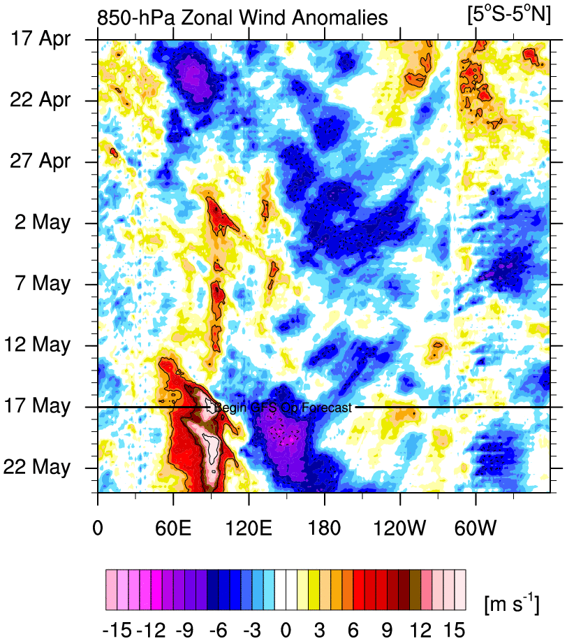
Moving on. Briefly I do want to still offer some hope as I believe there is a legitimate reason to see optimism in this abysmal winter. Looking at the GEFS ensemble map posted above he notes the trough is in the west and the ridge is in the east. This is correct. Result is fairly plain and fairly simple. Torch in the east while cool in the west. Here is the 850mb temp anomalies to show you. (if your faint at heart or squeamish you may want to look away now---CP Im referring specifically to you here)

HOWEVER; While yes there is a trough in the west and a ridge in the east take note the ridge up into the Alaska region: Image is the exact same timeframe as Franks image as well as mine. Both GEFS ens and Euro ensembles agree:


This is incredibly important as this is our EPO region and indicates that over the next 3-5days our EPO is going negative. The EPO region when negative can be one of the most important teleconnections for our area in the latter part of the winter season as the cold is still just to our north.
So why am I bringing this up? Well because once again the day 5-7 day time frame offers up a cross roads between the GEFS and the EPS model suites.
Here is the surface map of the EPS for once again the same time frame. Its easy to see that by day 5 (Thursday into Friday time frame) we have the dreaded cutter, however, pay attention to the big HP building over Canada. A piece of the western trough is forced to break off and come east and this is going to drive the cold air that is still to our immediate north back south once again into the conus once this system passes, such that you can see the 850mb anomalies back BN into our area once again by Saturday.


But does it have staying power??? Here in lies the cross roads. Once again a discussion about the MJO comes into play. In prev discussion I have pointed out how we still are in the warm phases of the MJO which leads to the resistance in the form of a ridge to our east centered somewhere in the Atlantic that wants to flex its western flank into the EC; which is why our storm track has been forced too far west leaving us warm sectored for our events. However, I also made claim that IF the MJO can drop in amplitude and/or esp if it can make its way into favorable cold phases then that resistance would begin to relax and allow the storm track to shift east and south.
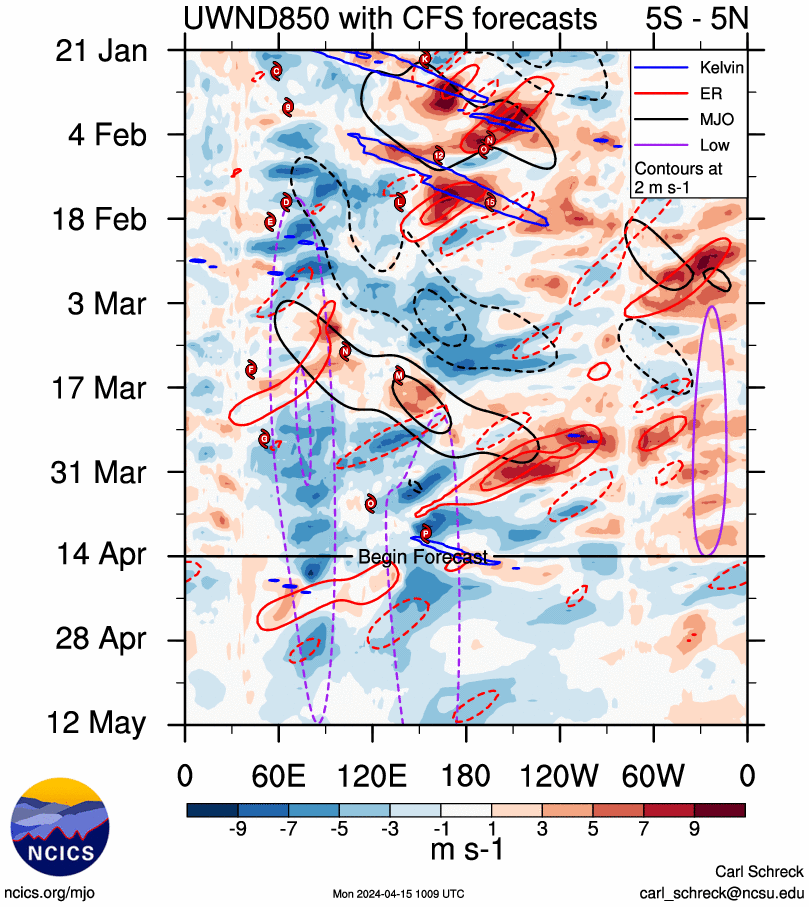
Here are the MJO forecasts from yesterday Feb 2nd for GEFS and Euro. You don't have to know what your looking at to plainly see they are very different from one another.


The little bullseye indicated where we are now in phase 7. However you can see that in 5-7days from now the GEFS want to take the MJO wave and loop it back around back into phase 6 and 7 with some serious amplitude; whereas the Euro wants to de-amplify the wave and bring it out into phase 8.
Now in situations like these when you look at the model runs for the ensembles and compare to their respective MJO forecast you have to ask yourselves do they agree with each other? And the answer for both GEFS and EPS is YES. Both of their model outputs agree with their respective MJO forecasts. GGEFS first. Below is the 500mb snap shots basically Day 7-13. Take particular notice to the EPO region(ridge up into Alaska) I previously mentioned. It retrogrades to pretty much south of the eastern part of the Aleutian islands. The result is a much more pronounced western trough eastern ridge look. This makes sense with the phase 6&7 forecast it has.


HOWEVER; Here is the EPS forecast going forward. Notice the ridging remains very potent up into our EPO region which maintains the cold push I alluded to above. (Note: in both models there is also a weak neg to neutral NAO look as well) If the EPS is correct the resistance, the Atlantic ridge pushing its way into the EC compliments of the warm phases of the MJO, backs off because we now get into phase 8 which is a cold phase, and the -EPO is allowed to establish itself which in turn starts to drive the cold air first South, but eventually "bleeds" east setting up the boundary layer S&E of us. And while Frank mentioned above that he thought he maybe saw a SWFE(south west flow event) on the modeling for the weekend set up but now its gone, I would argue that if the Euro modeling is correct it will begin to resurface on the operational models with consistency in the next 3-5days. For those who need clarification a SWFE is where we get waves of LP develop along this boundary layer. This boundary layer is the "baroclinic zone"(area where there is a large temp gradient). Very cold to the N&W of the boundary ad warm to the S&E. When LP ride along this you get very warm moist air being driven up and over the cold air(LP=counterclockwise flow) which leads to precipitation events along the boundary. These events can be quite significant despite only being very weak LP systems due to the enhanced vertical motion created by the steep temp gradient. In addition if the timing is right, if there is a northern piece of energy that interacts with the weak southern piece of energy we could get more significant cyclogenesis and a more significant winter storm as well. This set up is highly contingent on what happens to the MJO. If the GEFS is correct say bye bye to any snow threats during the week 2 time frame. If the Euro is correct then we will have multiple snow chances beginning next weekend and into that following week. Over the next 3-5days we should see which MJO forecasts begins to verify.


Let me end with this....If the GEFS is more correct then the snow chances are very slim, but if the EPS is correct then snow chances are really good; however, even if the EPS is correct the exact placement of the boundary layer relative to our region will then become extremely important. So even if EPS is correct please for the love of God and all that is holy remember it still may not work out in your backyard. But if the GEFS is correct even though the chances are slim we could still see a piece breakoff the western trough that if the timing is right lead to a snow event. We've seen it happen before. Enjoy the Super Bowl folks, and for a day Go RAMS!!!!!
We track!!

_________________
"In weather and in life, there's no winning and losing; there's only winning and learning."
WINTER 2012/2013 TOTALS 43.65"WINTER 2017/2018 TOTALS 62.85" WINTER 2022/2023 TOTALS 4.9"
WINTER 2013/2014 TOTALS 64.85"WINTER 2018/2019 TOTALS 14.25" WINTER 2023/2024 TOTALS 13.1"
WINTER 2014/2015 TOTALS 71.20"WINTER 2019/2020 TOTALS 6.35"
WINTER 2015/2016 TOTALS 35.00"WINTER 2020/2021 TOTALS 37.75"
WINTER 2016/2017 TOTALS 42.25"WINTER 2021/2022 TOTALS 31.65"

sroc4- Admin
- Posts : 8331
Reputation : 301
Join date : 2013-01-07
Location : Wading River, LI
Re: Long Range Thread 18.0
![]() by hyde345 Sun Feb 03, 2019 10:58 am
by hyde345 Sun Feb 03, 2019 10:58 am

hyde345- Pro Enthusiast
- Posts : 1082
Reputation : 48
Join date : 2013-01-08
Location : Hyde Park, NY
Re: Long Range Thread 18.0
![]() by amugs Sun Feb 03, 2019 11:35 am
by amugs Sun Feb 03, 2019 11:35 am
I have to disagree with Frank and the GEFS. Sorry look at the charts the latest show the WWB at the dateline and the mjo wave going from 8 to 1 to possibly 2.


The GEFS have a strong phase 8 now and it LR maps TOTALLY disgree with this phase

The EURO is more dampened but still significant

So being the ever optomist I am in agreement to with Sri and we'll keep a close eye on this pattern much to some sharing here. Take the retraction from the cold which is NORMAL folks after an arctic blast and we'll reload. How long remains to be seen of course but the data is in a more positive direction overall and we'll see how the models react to this.
Ventrice has a great thread about the Kevin Wave or WWB wave for the mjo. Can't post it here but go on tweeter and see for oneself.
https://twitter.com/MJVentrice/status/1092031733560680448?s=19
_________________
Mugs
AKA:King: Snow Weenie
Self Proclaimed
WINTER 2014-15 : 55.12" +.02 for 6 coatings (avg. 35")
WINTER 2015-16 Total - 29.8" (Avg 35")
WINTER 2016-17 : 39.5" so far

amugs- Advanced Forecaster - Mod

- Posts : 15093
Reputation : 213
Join date : 2013-01-07
Age : 54
Location : Hillsdale,NJ
Re: Long Range Thread 18.0
![]() by CPcantmeasuresnow Sun Feb 03, 2019 12:33 pm
by CPcantmeasuresnow Sun Feb 03, 2019 12:33 pm
amugs wrote:Scott fabulous post.
I have to disagree with Frank and the GEFS. Sorry look at the charts the latest show the WWB at the dateline and the mjo wave going from 8 to 1 to possibly 2.
The GEFS have a strong phase 8 now and it LR maps TOTALLY disgree with this phase
The EURO is more dampened but still significant
So being the ever optomist I am in agreement to with Sri and we'll keep a close eye on this pattern much to some sharing here. Take the retraction from the cold which is NORMAL folks after an arctic blast and we'll reload. How long remains to be seen of course but the data is in a more positive direction overall and we'll see how the models react to this.
Ventrice has a great thread about the Kevin Wave or WWB wave for the mjo. Can't post it here but go on tweeter and see for oneself.
https://twitter.com/MJVentrice/status/1092031733560680448?s=19
I always love your optimistic take Mugs, I'll just say one thing. It seems to me this winter anytime the MJO enters phase 8 as brief as it is, it always seems to want to jump right into the COD and back to phase 4, bypassing Phase one and two completely. I'm, not sure I follow why you believe it will be different this time around. Also what are the chances we finally get a sustained +PNA?

CPcantmeasuresnow- Wx Statistician Guru
- Posts : 7274
Reputation : 230
Join date : 2013-01-07
Age : 103
Location : Eastern Orange County, NY
Re: Long Range Thread 18.0
![]() by CPcantmeasuresnow Sun Feb 03, 2019 1:27 pm
by CPcantmeasuresnow Sun Feb 03, 2019 1:27 pm
jmanley32 wrote:Frank congrats and bring on spring, you know when Frank says we are done for the year its real. What rank does 8 inches fall under for lowest snowfall in my area stats guys? I doubt its the lowest but its got to be darn close. I will be happy to have a snowless and warmer march so i can get out and do my thing.
There are no official NWS reporting stations in Yonker Jman. Your closest would be Central Park which Geographically is no more than 10 miles from you.
In Central Park the 7.5 inches so far this season makes it the 7th least snowiest winter in 150 years of record keeping. Still a long way to go though IMO. February is historically the snowiest month and as I've repeated many times, three of the past 4 winters in NYC March has been the snowiest month.
CPcantmeasuresnow- Wx Statistician Guru
- Posts : 7274
Reputation : 230
Join date : 2013-01-07
Age : 103
Location : Eastern Orange County, NY
Re: Long Range Thread 18.0
![]() by CPcantmeasuresnow Sun Feb 03, 2019 1:29 pm
by CPcantmeasuresnow Sun Feb 03, 2019 1:29 pm
sroc4 wrote:Frank_Wx wrote:I recently was promoted in my job. My time this past week, and going forward, will be limited. So I am catching up on some posts today.algae888 wrote:I know it's been a very frustrating winter but the look on today's ensembles are the best I've seen so far this winter. That negative Nao finally looks legit as Heights will be building within the next 5 days and only get stronger from there. The 18 z GEFS also tries to pop a positive PNA the look on the ensembles really suggest a major winter storm. Mjo looks to be heading towards 8 and one . Let's see if we can salvage something this winter
There have been many moments when I saw the Ensembles over the last 2 weeks and thought to myself "wow, best I've seen so far this winter." But then I began to notice it just kept getting pushed back. We're now into February and the GEFS look as bad as they get. The Pacific is a complete and utter disaster, and unless the MJO saves us, which looks unlikely, we are done for this season. I suspected we could be done last week. Now my confidence of our area not getting to even normal snowfall is very high.
GEFS 500mb February 8th. Trough is on the wrong side of the country.mwilli5783 wrote:algae and everybody in here i would take anything right now if there's a major storm on the horizon (fingers crossed)
I was thinking we had a chance of a SWFE (southwest flow event) next weekend, but models backed off of it. Maybe it comes back but its doubtful. Other than that, I do not see anything else on the horizon.
Frank first off congrats on your promotion. Its always nice to see hard work get paid off. I'm pretty sure any of us who knew you from back at the 7 online days knew that you were going to be successful at what ever you do, so for me at least it comes as no surprise. Again congrats and good luck in the new chapter of your professional career.
Moving on. Briefly I do want to still offer some hope as I believe there is a legitimate reason to see optimism in this abysmal winter. Looking at the GEFS ensemble map posted above he notes the trough is in the west and the ridge is in the east. This is correct. Result is fairly plain and fairly simple. Torch in the east while cool in the west. Here is the 850mb temp anomalies to show you. (if your faint at heart or squeamish you may want to look away now---CP Im referring specifically to you here)
HOWEVER; While yes there is a trough in the west and a ridge in the east take note the ridge up into the Alaska region: Image is the exact same timeframe as Franks image as well as mine. Both GEFS ens and Euro ensembles agree:
This is incredibly important as this is our EPO region and indicates that over the next 3-5days our EPO is going negative. The EPO region when negative can be one of the most important teleconnections for our area in the latter part of the winter season as the cold is still just to our north.
So why am I bringing this up? Well because once again the day 5-7 day time frame offers up a cross roads between the GEFS and the EPS model suites.
Here is the surface map of the EPS for once again the same time frame. Its easy to see that by day 5 (Thursday into Friday time frame) we have the dreaded cutter, however, pay attention to the big HP building over Canada. A piece of the western trough is forced to break off and come east and this is going to drive the cold air that is still to our immediate north back south once again into the conus once this system passes, such that you can see the 850mb anomalies back BN into our area once again by Saturday.
But does it have staying power??? Here in lies the cross roads. Once again a discussion about the MJO comes into play. In prev discussion I have pointed out how we still are in the warm phases of the MJO which leads to the resistance in the form of a ridge to our east centered somewhere in the Atlantic that wants to flex its western flank into the EC; which is why our storm track has been forced too far west leaving us warm sectored for our events. However, I also made claim that IF the MJO can drop in amplitude and/or esp if it can make its way into favorable cold phases then that resistance would begin to relax and allow the storm track to shift east and south.
Here are the MJO forecasts from yesterday Feb 2nd for GEFS and Euro. You don't have to know what your looking at to plainly see they are very different from one another.
The little bullseye indicated where we are now in phase 7. However you can see that in 5-7days from now the GEFS want to take the MJO wave and loop it back around back into phase 6 and 7 with some serious amplitude; whereas the Euro wants to de-amplify the wave and bring it out into phase 8.
Now in situations like these when you look at the model runs for the ensembles and compare to their respective MJO forecast you have to ask yourselves do they agree with each other? And the answer for both GEFS and EPS is YES. Both of their model outputs agree with their respective MJO forecasts. GGEFS first. Below is the 500mb snap shots basically Day 7-13. Take particular notice to the EPO region(ridge up into Alaska) I previously mentioned. It retrogrades to pretty much south of the eastern part of the Aleutian islands. The result is a much more pronounced western trough eastern ridge look. This makes sense with the phase 6&7 forecast it has.
HOWEVER; Here is the EPS forecast going forward. Notice the ridging remains very potent up into our EPO region which maintains the cold push I alluded to above. (Note: in both models there is also a weak neg to neutral NAO look as well) If the EPS is correct the resistance, the Atlantic ridge pushing its way into the EC compliments of the warm phases of the MJO, backs off because we now get into phase 8 which is a cold phase, and the -EPO is allowed to establish itself which in turn starts to drive the cold air first South, but eventually "bleeds" east setting up the boundary layer S&E of us. And while Frank mentioned above that he thought he maybe saw a SWFE(south west flow event) on the modeling for the weekend set up but now its gone, I would argue that if the Euro modeling is correct it will begin to resurface on the operational models with consistency in the next 3-5days. For those who need clarification a SWFE is where we get waves of LP develop along this boundary layer. This boundary layer is the "baroclinic zone"(area where there is a large temp gradient). Very cold to the N&W of the boundary ad warm to the S&E. When LP ride along this you get very warm moist air being driven up and over the cold air(LP=counterclockwise flow) which leads to precipitation events along the boundary. These events can be quite significant despite only being very weak LP systems due to the enhanced vertical motion created by the steep temp gradient. In addition if the timing is right, if there is a northern piece of energy that interacts with the weak southern piece of energy we could get more significant cyclogenesis and a more significant winter storm as well. This set up is highly contingent on what happens to the MJO. If the GEFS is correct say bye bye to any snow threats during the week 2 time frame. If the Euro is correct then we will have multiple snow chances beginning next weekend and into that following week. Over the next 3-5days we should see which MJO forecasts begins to verify.
Let me end with this....If the GEFS is more correct then the snow chances are very slim, but if the EPS is correct then snow chances are really good; however, even if the EPS is correct the exact placement of the boundary layer relative to our region will then become extremely important. So even if EPS is correct please for the love of God and all that is holy remember it still may not work out in your backyard. But if the GEFS is correct even though the chances are slim we could still see a piece breakoff the western trough that if the timing is right lead to a snow event. We've seen it happen before. Enjoy the Super Bowl folks, and for a day Go RAMS!!!!!
We track!!
Great post Doc, same question to you.
It seems to me this winter anytime the MJO enters phase 8 as brief as it is, it always seems to want to jump right into the COD and back to phase 4, bypassing Phase one and two completely. I'm, not sure I follow why you believe it will be different this time around. Also what are the chances we finally get a sustained +PNA?
CPcantmeasuresnow- Wx Statistician Guru
- Posts : 7274
Reputation : 230
Join date : 2013-01-07
Age : 103
Location : Eastern Orange County, NY
Re: Long Range Thread 18.0
![]() by sroc4 Sun Feb 03, 2019 2:58 pm
by sroc4 Sun Feb 03, 2019 2:58 pm
CPcantmeasuresnow wrote:
Great post Doc, same question to you.
It seems to me this winter anytime the MJO enters phase 8 as brief as it is, it always seems to want to jump right into the COD and back to phase 4, bypassing Phase one and two completely. I'm, not sure I follow why you believe it will be different this time around. Also what are the chances we finally get a sustained +PNA?
Hey Cp. Im not sure that I posted anything specific stating that I thought this time would be different. I simply pointed out that there are two different camps beyond the 5-7day time frame. Both camps show the emergenge of the -EPO in 5days+/-. Its what happens after where the divergence of solns occurs. As Mugs posted todays MJO forecast has the Euro with even more amplitude than yesterdays forecast, and GEFS indicates for the first time making it into 8 albeit still differently than how the euro gets it there.
I personally believe we see it come out in 8 more so like the Euro because of the way the euro handled the last trip from the MJO through phases 5, 6, and 7 before entering 8. You have a 100% valid point that in the prev trip through 8 it only lasted a very short time. Only about 7 days to be exact. The MJO has been in a favorale phase for a mere 7 days out of the last 30-35 or so. The rest of the days have been in the warm phases or the COD. Its hard to get anything going with such a short duration.
So why will it be different this time? Well I don't have specific reasoning, but I also am not realy making the claim. It very well may do a similar trip though 8 for a week +/- and come right back towards the warmer phase again. Im hoping not but who knows at this stage. The SSTA along the Pac and IO equator aren't all that diff now than in Jan, but I will say that seasonally and climatologically we are entering a different time frame than late dec into Jan. vs now we enter mid Feb(which is a short month) into early March.
All Im saying is that if we see it emerging out in 8 by next weekend the resistance to the east relaxes and our odds go back up. If it only lasts a week again we get a short window and have to hope the individual ingredients come together earlier this time. Last time it was in 8 for 1 week the ingredients came together for our storm, Jan 19th-20th, while it was already emerging out in 4 rather than the middle of 8. That set up we had the cold ahead of the system, but the resistance flexed because atmospherically it was already to do so as it reached our coast as it was in 4.
We'll see. First thing I wAnt to see is if we are coming out in 8 or not. Then Ill worry about for how long.
_________________
"In weather and in life, there's no winning and losing; there's only winning and learning."
WINTER 2012/2013 TOTALS 43.65"WINTER 2017/2018 TOTALS 62.85" WINTER 2022/2023 TOTALS 4.9"
WINTER 2013/2014 TOTALS 64.85"WINTER 2018/2019 TOTALS 14.25" WINTER 2023/2024 TOTALS 13.1"
WINTER 2014/2015 TOTALS 71.20"WINTER 2019/2020 TOTALS 6.35"
WINTER 2015/2016 TOTALS 35.00"WINTER 2020/2021 TOTALS 37.75"
WINTER 2016/2017 TOTALS 42.25"WINTER 2021/2022 TOTALS 31.65"
sroc4- Admin
- Posts : 8331
Reputation : 301
Join date : 2013-01-07
Location : Wading River, LI
Re: Long Range Thread 18.0
![]() by sroc4 Sun Feb 03, 2019 3:05 pm
by sroc4 Sun Feb 03, 2019 3:05 pm
_________________
"In weather and in life, there's no winning and losing; there's only winning and learning."
WINTER 2012/2013 TOTALS 43.65"WINTER 2017/2018 TOTALS 62.85" WINTER 2022/2023 TOTALS 4.9"
WINTER 2013/2014 TOTALS 64.85"WINTER 2018/2019 TOTALS 14.25" WINTER 2023/2024 TOTALS 13.1"
WINTER 2014/2015 TOTALS 71.20"WINTER 2019/2020 TOTALS 6.35"
WINTER 2015/2016 TOTALS 35.00"WINTER 2020/2021 TOTALS 37.75"
WINTER 2016/2017 TOTALS 42.25"WINTER 2021/2022 TOTALS 31.65"
sroc4- Admin
- Posts : 8331
Reputation : 301
Join date : 2013-01-07
Location : Wading River, LI
Page 21 of 36 • 1 ... 12 ... 20, 21, 22 ... 28 ... 36 ![]()