January 25th Winter Storm
+7
jmanley32
SENJsnowman
hyde345
docstox12
CPcantmeasuresnow
dkodgis
Frank_Wx
11 posters
Page 2 of 2 •  1, 2
1, 2
 Re: January 25th Winter Storm
This 500mb vort map valid for Friday morning shows why our area will struggle to see snow. Those 2 'eye-like' features in the Midwest represent the northern stream energy. It actually comes in 2 separate vorts. Because they are already closed off, hence the round shape, the phase will occur WELL west of us back toward Chicago land. Normally this results in a cutter. However, this becomes an upper level low because of the PNA spike and blocking over Canada. The PNA spike is normally a good thing but there is a trough off the west coast crashing into the ridge which forces everything to slide east disrupting the flow.

Heights rise along the east coast and the ULL ends up tracking either over or just N&W of us. Unfortunately it is not a good set-up, but one worth watching for at least 1 more day especially N&W of NYC.

Heights rise along the east coast and the ULL ends up tracking either over or just N&W of us. Unfortunately it is not a good set-up, but one worth watching for at least 1 more day especially N&W of NYC.
 Re: January 25th Winter Storm
did it not snow in DC when it was 70* out....lolFrank_Wx wrote:The only thing worse than cold/dry is cold with 33 degrees and rain. That is what Saturday is shaping up to be for most.
weatherwatchermom- Senior Enthusiast

- Posts : 3793
Join date : 2014-11-25
 Re: January 25th Winter Storm
Abcnews says it could be a nor’easter.

dkodgis- Senior Enthusiast

- Posts : 2560
Reputation : 98
Join date : 2013-12-29
 Re: January 25th Winter Storm
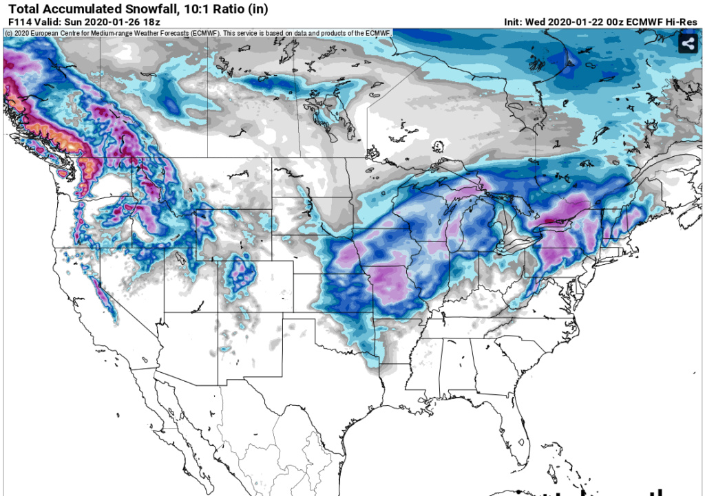
Bad air mass + bad track + no dynamics --> Next (for most)
I believe this picture is a fair representation of what to expect. LHV folks may get a modest accumulation, but with the bad air mass, I'm skeptical of much over 2".
Significant snow most likely confined to Western NY State, Berkshires, Catskills, Central PA and mountains of CNE/NNE.
Even Albany I'd be skeptical of significant amounts as they are not elevated, but you go west of there towards East Berne then that will be copious amounts of snow above 1000'.

heehaw453- Advanced Forecaster

- Posts : 3906
Reputation : 86
Join date : 2014-01-20
Location : Bedminster Township, PA Elevation 600' ASL
 Re: January 25th Winter Storm
Heehaw453, being in the LHV I'll take those two inches and run.Great work all week on this, you were skeptical all the way.
Isotherm is spot on so far with his long range winter forecast of below normal to normal snow.
Isotherm is spot on so far with his long range winter forecast of below normal to normal snow.

docstox12- Wx Statistician Guru

- Posts : 8530
Reputation : 222
Join date : 2013-01-07
Age : 73
Location : Monroe NY
 Re: January 25th Winter Storm
I think this one is about done unless you live in Sullivan or higher elevations (1,000 ft or higher) of Ulster and NW Orange County and maybe above 1,000 feet in extreme NWNJ and NEPA.
It also appears the month of January is just about finished too. Good riddance.
It also appears the month of January is just about finished too. Good riddance.

CPcantmeasuresnow- Wx Statistician Guru

- Posts : 7274
Reputation : 230
Join date : 2013-01-07
Age : 103
Location : Eastern Orange County, NY
Page 2 of 2 •  1, 2
1, 2
Permissions in this forum:
You cannot reply to topics in this forum|
|
|

 Home
Home
