
 Search
Long Range Discussion 20(20) (Ha!)
Page 14 of 30 •  1 ... 8 ... 13, 14, 15 ... 22 ... 30
 ![]()
Re: Long Range Discussion 20(20) (Ha!)
![]() by Irish Sun Dec 27, 2020 12:08 am
by Irish Sun Dec 27, 2020 12:08 am
amugs wrote:Well this is interesting by GFS for 1/1 NNJ, HV and EPA

Looks like another nice, cool rain storm for me. Awesome!
Irish- Pro Enthusiast

- Posts : 788
Join date : 2019-01-16
Re: Long Range Discussion 20(20) (Ha!)
![]() by heehaw453 Sun Dec 27, 2020 9:33 am
by heehaw453 Sun Dec 27, 2020 9:33 am
amugs wrote:Well this is interesting by GFS for 1/1 NNJ, HV and EPA
With a better track this would be warning level snowfall as there is a CAD with high pressure in Quebec. With WAR in place the ULL just gets shoved right through Detroit. Expect surface cold to hold on much longer than mid levels and if the precip can come in fast and hard enough then a few inches could be possible in those areas. It's also possible CAD could be stronger than currently modeled but with a track like that there are hard limits to any potential.
heehaw453- Advanced Forecaster

- Posts : 3906
Join date : 2014-01-20
amugs likes this post
Re: Long Range Discussion 20(20) (Ha!)
![]() by Frank_Wx Sun Dec 27, 2020 9:37 am
by Frank_Wx Sun Dec 27, 2020 9:37 am
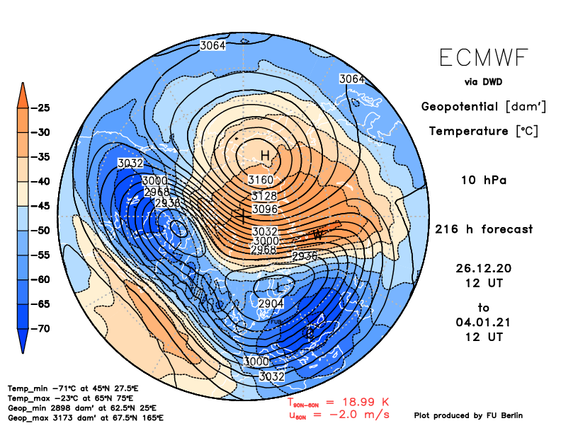
Last nights EURO continued to show an official SSWE taking place on or about January 5th. On this map that is shown by the negative U winds (mean zonal winds) of -2.0 m/s at 60N 10hPa. Also from this map you can see the EURO successfully splits the PV through Wave 1 warming - one HP over Siberia.
This a top down warming event, meaning the wind reversals to easterly begin at 1 hPa and propagate down toward the mid levels of the strat. The deep blue at 1 hPa and 70N suggest an anomalous warming event which is why the EURO is able to split the PV with just one wave.

Heat flux is pointing poleward and growing with time. The attack on the SPV is real, and evidence is mounting that it may not be able to withstand the attack and we’re beginning the process of permanently displacing the SPV.
No change from the GFS. In fact, it’s taking the wind reversal to another level outside of the 30 year average. Questions that remains:
1. Will there be a wave 2 warming event? Some models like the GFS only displace the SPV and the split doesn’t occur until January 12th when there are two warming events happening simultaneously (one High in the PAC/US side and another in the ATL). Our area would benefit most from seeing a SPV split through Wave 2 warming not just Wave 1.
2. What does this do to our pattern at the trop and when will we begin seeing the affects? I don’t think models will properly recognize the SSW until the New Year, and there is going to be wild swings in long range forecasts until that happens. Snow chances from now until Jan 10th will be limited and/or minor. We need to turn the NAO block from east to west based, but most importantly, break the +EPO pattern that’s hogging all of the cold air. It’s possible the SSW acts as a domino and we begin seeing tropical activity (MJO) develop around Jan 10th. This forcing should be enough to remove the lower heights over Alaska and bring them into the CONUS.
_________________
_______________________________________________________________________________________________________
CLICK HERE to view NJ Strong Snowstorm Classifications

Frank_Wx- Godzilla Seeker

- Posts : 21305
Reputation : 328
Join date : 2013-01-05
Age : 31
Location : Jersey City, NJ -

Re: Long Range Discussion 20(20) (Ha!)
![]() by amugs Sun Dec 27, 2020 11:46 am
by amugs Sun Dec 27, 2020 11:46 am
Anyway I'd say we have an East Based Nina developing?? Which would mean a colder than normal winter possible, other factors at play as well.

_________________
Mugs
AKA:King: Snow Weenie
Self Proclaimed
WINTER 2014-15 : 55.12" +.02 for 6 coatings (avg. 35")
WINTER 2015-16 Total - 29.8" (Avg 35")
WINTER 2016-17 : 39.5" so far

amugs- Advanced Forecaster - Mod

- Posts : 15093
Reputation : 213
Join date : 2013-01-07
Age : 54
Location : Hillsdale,NJ
Re: Long Range Discussion 20(20) (Ha!)
![]() by amugs Mon Dec 28, 2020 12:04 am
by amugs Mon Dec 28, 2020 12:04 am

_________________
Mugs
AKA:King: Snow Weenie
Self Proclaimed
WINTER 2014-15 : 55.12" +.02 for 6 coatings (avg. 35")
WINTER 2015-16 Total - 29.8" (Avg 35")
WINTER 2016-17 : 39.5" so far
amugs- Advanced Forecaster - Mod
- Posts : 15093
Reputation : 213
Join date : 2013-01-07
Age : 54
Location : Hillsdale,NJ
Re: Long Range Discussion 20(20) (Ha!)
![]() by heehaw453 Mon Dec 28, 2020 8:05 am
by heehaw453 Mon Dec 28, 2020 8:05 am
heehaw453- Advanced Forecaster
- Posts : 3906
Reputation : 86
Join date : 2014-01-20
Location : Bedminster Township, PA Elevation 600' ASL
Re: Long Range Discussion 20(20) (Ha!)
![]() by heehaw453 Mon Dec 28, 2020 8:15 am
by heehaw453 Mon Dec 28, 2020 8:15 am
Get this trough to go a bit negative and we'd be in business. This is a 6+ days out and there will be adjustments.

heehaw453- Advanced Forecaster
- Posts : 3906
Reputation : 86
Join date : 2014-01-20
Location : Bedminster Township, PA Elevation 600' ASL
Re: Long Range Discussion 20(20) (Ha!)
![]() by heehaw453 Mon Dec 28, 2020 8:33 am
by heehaw453 Mon Dec 28, 2020 8:33 am

heehaw453- Advanced Forecaster
- Posts : 3906
Reputation : 86
Join date : 2014-01-20
Location : Bedminster Township, PA Elevation 600' ASL
Re: Long Range Discussion 20(20) (Ha!)
![]() by heehaw453 Mon Dec 28, 2020 11:52 am
by heehaw453 Mon Dec 28, 2020 11:52 am

heehaw453- Advanced Forecaster
- Posts : 3906
Reputation : 86
Join date : 2014-01-20
Location : Bedminster Township, PA Elevation 600' ASL
phil155 likes this post
Re: Long Range Discussion 20(20) (Ha!)
![]() by phil155 Mon Dec 28, 2020 12:08 pm
by phil155 Mon Dec 28, 2020 12:08 pm
heehaw453 wrote:I understand this is para GFS and take it with a grain of salt, but this is what you'd want to see for 1/3 if it were to materialize.
Does this mean we may have a chance, even if it is a slim chance
phil155- Pro Enthusiast
- Posts : 475
Reputation : 4
Join date : 2019-12-16
Re: Long Range Discussion 20(20) (Ha!)
![]() by heehaw453 Mon Dec 28, 2020 1:07 pm
by heehaw453 Mon Dec 28, 2020 1:07 pm
phil155 wrote:heehaw453 wrote:I understand this is para GFS and take it with a grain of salt, but this is what you'd want to see for 1/3 if it were to materialize.
Does this mean we may have a chance, even if it is a slim chance
I would put the threat level at low right now. Let's see what guidance shows on Wednesday.
heehaw453- Advanced Forecaster
- Posts : 3906
Reputation : 86
Join date : 2014-01-20
Location : Bedminster Township, PA Elevation 600' ASL
Re: Long Range Discussion 20(20) (Ha!)
![]() by phil155 Mon Dec 28, 2020 2:07 pm
by phil155 Mon Dec 28, 2020 2:07 pm
heehaw453 wrote:phil155 wrote:heehaw453 wrote:I understand this is para GFS and take it with a grain of salt, but this is what you'd want to see for 1/3 if it were to materialize.
Does this mean we may have a chance, even if it is a slim chance
I would put the threat level at low right now. Let's see what guidance shows on Wednesday.
Wait and hopefully we will have something to track
phil155- Pro Enthusiast
- Posts : 475
Reputation : 4
Join date : 2019-12-16
SENJsnowman likes this post
Re: Long Range Discussion 20(20) (Ha!)
![]() by heehaw453 Mon Dec 28, 2020 3:26 pm
by heehaw453 Mon Dec 28, 2020 3:26 pm

heehaw453- Advanced Forecaster
- Posts : 3906
Reputation : 86
Join date : 2014-01-20
Location : Bedminster Township, PA Elevation 600' ASL
Re: Long Range Discussion 20(20) (Ha!)
![]() by sroc4 Mon Dec 28, 2020 4:12 pm
by sroc4 Mon Dec 28, 2020 4:12 pm
heehaw453 wrote:Look at the latest AO projections just absolutely tank. If true it will just take a little movement of the NAO and PAC ridging to make for some very interesting times. You also get the feeling with these kinds of deviations that it may have some staying power.
Hopefully it doesnt lead to suppression depression. Sometimes too much of a good thing can be a bad thing.
_________________
"In weather and in life, there's no winning and losing; there's only winning and learning."
WINTER 2012/2013 TOTALS 43.65"WINTER 2017/2018 TOTALS 62.85" WINTER 2022/2023 TOTALS 4.9"
WINTER 2013/2014 TOTALS 64.85"WINTER 2018/2019 TOTALS 14.25" WINTER 2023/2024 TOTALS 13.1"
WINTER 2014/2015 TOTALS 71.20"WINTER 2019/2020 TOTALS 6.35"
WINTER 2015/2016 TOTALS 35.00"WINTER 2020/2021 TOTALS 37.75"
WINTER 2016/2017 TOTALS 42.25"WINTER 2021/2022 TOTALS 31.65"

sroc4- Admin
- Posts : 8331
Reputation : 301
Join date : 2013-01-07
Location : Wading River, LI
Re: Long Range Discussion 20(20) (Ha!)
![]() by algae888 Mon Dec 28, 2020 4:16 pm
by algae888 Mon Dec 28, 2020 4:16 pm

algae888- Advanced Forecaster
- Posts : 5311
Reputation : 46
Join date : 2013-02-05
Age : 61
Location : mt. vernon, new york
CPcantmeasuresnow likes this post
Re: Long Range Discussion 20(20) (Ha!)
![]() by algae888 Mon Dec 28, 2020 4:26 pm
by algae888 Mon Dec 28, 2020 4:26 pm
griteater
@griteater
Current Siberia High showing at 1076mb, not far off the world record high of 1084mb on Dec 31, 1968. Maybe this is a sign (ha) as Jan-Mar 1969 went on to be one of the all-time great Greenland Blocking winters
Sayaka Mori
@sayakasofiamori
Siberia's #Oymyakon had -57.2C (-71F) on Monday due to a significantly developed Siberian High. Its central #pressure now is 1076hPa. Though it is lower than the world's highest pressure of 1083.8hPa recorded in #Siberia in 1968, it's definitely amazing.
algae888- Advanced Forecaster
- Posts : 5311
Reputation : 46
Join date : 2013-02-05
Age : 61
Location : mt. vernon, new york
Re: Long Range Discussion 20(20) (Ha!)
![]() by amugs Mon Dec 28, 2020 4:43 pm
by amugs Mon Dec 28, 2020 4:43 pm

The upcoming pattern with the W based Greenland Blo k it retrograde over the top and kicks rhe LP out of western CAN and AK to thus promoting a PNA and N EPO. Time will tell but if you keep that Ural HP as grittier tweeted about i. That spot you will reinforce the N NAO. Time will tell but let's see. Jan 4th storm is on the table as pe EURO to help kick things off.
Age of Aquarius peeps!!
_________________
Mugs
AKA:King: Snow Weenie
Self Proclaimed
WINTER 2014-15 : 55.12" +.02 for 6 coatings (avg. 35")
WINTER 2015-16 Total - 29.8" (Avg 35")
WINTER 2016-17 : 39.5" so far
amugs- Advanced Forecaster - Mod
- Posts : 15093
Reputation : 213
Join date : 2013-01-07
Age : 54
Location : Hillsdale,NJ
Re: Long Range Discussion 20(20) (Ha!)
![]() by jmanley32 Mon Dec 28, 2020 5:45 pm
by jmanley32 Mon Dec 28, 2020 5:45 pm

jmanley32- Senior Enthusiast

- Posts : 20513
Reputation : 108
Join date : 2013-12-12
Age : 42
Location : Yonkers, NY
Re: Long Range Discussion 20(20) (Ha!)
![]() by amugs Mon Dec 28, 2020 6:33 pm
by amugs Mon Dec 28, 2020 6:33 pm
Massive heat flux

Huge wind reversal

_________________
Mugs
AKA:King: Snow Weenie
Self Proclaimed
WINTER 2014-15 : 55.12" +.02 for 6 coatings (avg. 35")
WINTER 2015-16 Total - 29.8" (Avg 35")
WINTER 2016-17 : 39.5" so far
amugs- Advanced Forecaster - Mod
- Posts : 15093
Reputation : 213
Join date : 2013-01-07
Age : 54
Location : Hillsdale,NJ
Re: Long Range Discussion 20(20) (Ha!)
![]() by lglickman1 Mon Dec 28, 2020 7:46 pm
by lglickman1 Mon Dec 28, 2020 7:46 pm
lglickman1- Pro Enthusiast
- Posts : 319
Reputation : 0
Join date : 2013-02-05
Location : New Rochelle, NY
Re: Long Range Discussion 20(20) (Ha!)
![]() by rb924119 Tue Dec 29, 2020 10:39 am
by rb924119 Tue Dec 29, 2020 10:39 am
rb924119- Meteorologist

- Posts : 6889
Reputation : 194
Join date : 2013-02-06
Age : 32
Location : Greentown, Pa
Re: Long Range Discussion 20(20) (Ha!)
![]() by Frank_Wx Tue Dec 29, 2020 12:37 pm
by Frank_Wx Tue Dec 29, 2020 12:37 pm
_________________
_______________________________________________________________________________________________________
CLICK HERE to view NJ Strong Snowstorm Classifications
Frank_Wx- Godzilla Seeker
- Posts : 21305
Reputation : 328
Join date : 2013-01-05
Age : 31
Location : Jersey City, NJ -
Re: Long Range Discussion 20(20) (Ha!)
![]() by heehaw453 Tue Dec 29, 2020 2:52 pm
by heehaw453 Tue Dec 29, 2020 2:52 pm

heehaw453- Advanced Forecaster
- Posts : 3906
Reputation : 86
Join date : 2014-01-20
Location : Bedminster Township, PA Elevation 600' ASL
Re: Long Range Discussion 20(20) (Ha!)
![]() by amugs Tue Dec 29, 2020 4:58 pm
by amugs Tue Dec 29, 2020 4:58 pm
Weak MJO pulse into phase 2 and 3
I think we need to be patient but the latest model run suits for the past cycle (4 runs) are getting stronger with the block. The PAC is a mess yes BUT the heights from teh AO and NAO will slowly push those Low heights out of Western BC and Alaska.
This map show these heights in orange for the Greenland Region spread over the top of CANADA into Alaska. So lets see what the next few days of runs show with this.
It is exciting to see and also to see the SSWE occurring. There is a coupling with the stratosphere and troposphere from model runs - EURO saying Jan 4 - GEFS say JAN 10 so time will tell.

Sorry but this is exciting to see - no storm is going into that block - suppression maybe but cutters - ain't happening - the storms are going to head North/Northeast when they feel the press. Maybe head North and then East - again time will tell.
Sunday into Mon is on the table as Haw said and I have been harping on the ICE ICE baby for NYD for N of I 80 and NW NJ - Orange, Rockland Cts.
_________________
Mugs
AKA:King: Snow Weenie
Self Proclaimed
WINTER 2014-15 : 55.12" +.02 for 6 coatings (avg. 35")
WINTER 2015-16 Total - 29.8" (Avg 35")
WINTER 2016-17 : 39.5" so far
amugs- Advanced Forecaster - Mod
- Posts : 15093
Reputation : 213
Join date : 2013-01-07
Age : 54
Location : Hillsdale,NJ
Re: Long Range Discussion 20(20) (Ha!)
![]() by amugs Tue Dec 29, 2020 5:15 pm
by amugs Tue Dec 29, 2020 5:15 pm

_________________
Mugs
AKA:King: Snow Weenie
Self Proclaimed
WINTER 2014-15 : 55.12" +.02 for 6 coatings (avg. 35")
WINTER 2015-16 Total - 29.8" (Avg 35")
WINTER 2016-17 : 39.5" so far
amugs- Advanced Forecaster - Mod
- Posts : 15093
Reputation : 213
Join date : 2013-01-07
Age : 54
Location : Hillsdale,NJ
Re: Long Range Discussion 20(20) (Ha!)
![]() by amugs Tue Dec 29, 2020 5:18 pm
by amugs Tue Dec 29, 2020 5:18 pm
Sudden stratospheric warming is underway! Here's a selection of radiosonde ascents from Russia & Mongolia at 12Z today, which captured the warming in the mid-stratosphere. https://t.co/zaxvOFTGnM pic.twitter.com/ig7zgioj5G
— Simon Lee (@SimonLeeWx) December 29, 2020
HOUSTON WE HAVE IGNITION!!
_________________
Mugs
AKA:King: Snow Weenie
Self Proclaimed
WINTER 2014-15 : 55.12" +.02 for 6 coatings (avg. 35")
WINTER 2015-16 Total - 29.8" (Avg 35")
WINTER 2016-17 : 39.5" so far
amugs- Advanced Forecaster - Mod
- Posts : 15093
Reputation : 213
Join date : 2013-01-07
Age : 54
Location : Hillsdale,NJ
Page 14 of 30 • 1 ... 8 ... 13, 14, 15 ... 22 ... 30 ![]()
|
|
|