DECEMBER 16th 17th 2020 Snow Threat???
+39
SNOW MAN
snowday111
MattyICE
Nyi1058
dsix85
SENJsnowman
larryrock72
Math23x7
WeatherBob
Dunnzoo
jimv45
weatherwatchermom
Artechmetals
mmanisca
GreyBeard
SoulSingMG
CPcantmeasuresnow
hyde345
frank 638
mwilli
Frank_Wx
Radz
docstox12
phil155
skinsfan1177
bobjohnsonforthehall
adamfitz1969
rb924119
billg315
Irish
Grselig
crippo84
jmanley32
amugs
nutleyblizzard
aiannone
heehaw453
algae888
sroc4
43 posters
Page 6 of 24
Page 6 of 24 •  1 ... 5, 6, 7 ... 15 ... 24
 Re: DECEMBER 16th 17th 2020 Snow Threat???
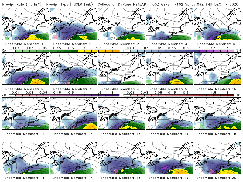
0z GFS is prodigious snow amounts I80 on south. The run had the storm further east and a bit strong than 18Z. As a result more snow towards coast.
Shows similar evolution of the storm getting kicked east instead of ENE due to block. I think they'll be some back on forth on this but at the end of the day it'll probably do the ENE thing. SNE is max far north of the threat area IMO. This is not riding up the coast to the Canadian Maritimes.
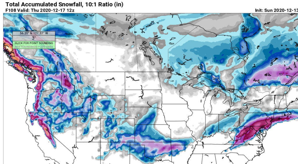
Shows similar evolution of the storm getting kicked east instead of ENE due to block. I think they'll be some back on forth on this but at the end of the day it'll probably do the ENE thing. SNE is max far north of the threat area IMO. This is not riding up the coast to the Canadian Maritimes.

heehaw453- Advanced Forecaster

- Posts : 3906
Join date : 2014-01-20
heehaw453- Advanced Forecaster

- Posts : 3906
Reputation : 86
Join date : 2014-01-20
Location : Bedminster Township, PA Elevation 600' ASL
 Re: DECEMBER 16th 17th 2020 Snow Threat???
Frank_Wx wrote:Irish wrote:Just looked at the updated forecast on weather.com and even though the predicted snow totals are 9-18 inches, the high temps are creeping up, which makes me nervous about the fear that warm air might get in.
Right, figured that. Just noticed that they started higher, then dipped and are now heading higher again. Even if it's too early, I was worried about trending in the wrong direction. We'll see what happens...
Temp forecasts are meaningless until within 48 hours

Irish- Pro Enthusiast

- Posts : 788
Reputation : 19
Join date : 2019-01-16
Age : 45
Location : Old Bridge, NJ
 Re: DECEMBER 16th 17th 2020 Snow Threat???
What an odd way to achieve a Godzilla. We’re not talking sub 980mb, barely even sub 990mb storm. It’s all qpf driven with cold air damming south in response to the pressing HP north
_________________
_______________________________________________________________________________________________________
CLICK HERE to view NJ Strong Snowstorm Classifications
 Re: DECEMBER 16th 17th 2020 Snow Threat???
heehaw453 wrote:0z GFS is prodigious snow amounts I80 on south. The run had the storm further east and a bit strong than 18Z. As a result more snow towards coast.
Shows similar evolution of the storm getting kicked east instead of ENE due to block. I think they'll be some back on forth on this but at the end of the day it'll probably do the ENE thing. SNE is max far north of the threat area IMO. This is not riding up the coast to the Canadian Maritimes.
Agree
_________________
_______________________________________________________________________________________________________
CLICK HERE to view NJ Strong Snowstorm Classifications
 Re: DECEMBER 16th 17th 2020 Snow Threat???
Frank_Wx wrote:What an odd way to achieve a Godzilla. We’re not talking sub 980mb, barely even sub 990mb storm. It’s all qpf driven with cold air damming south in response to the pressing HP north
Yes the WAA over the cold dry air is key. We'd probably get 6" even without much lift just do to that. The moderate storm just adds the lift to enhance the rates.
heehaw453- Advanced Forecaster

- Posts : 3906
Reputation : 86
Join date : 2014-01-20
Location : Bedminster Township, PA Elevation 600' ASL
 Re: DECEMBER 16th 17th 2020 Snow Threat???
Have to wait till the upper system is captured after it comes onshore tmrw. Differences of only 50 miles could mean a big difference in where the upper and lower systems are placed. The GFS just weakened the upper system this run and did not allow anybrush of warmer air in at the upper levels? Will Rb’s solution pan out with a striping lead low with stronger upper system? I want to wait till the Sunday night run to make any preliminary predictions.

WeatherBob- Meteorologist

- Posts : 683
Reputation : 83
Join date : 2013-12-13
Location : Caldwell, NJ - NW Essex County - Altitude 500 FT
SENJsnowman likes this post
 Re: DECEMBER 16th 17th 2020 Snow Threat???
WeatherBob wrote:Have to wait till the upper system is captured after it comes onshore tmrw. Differences of only 50 miles could mean a big difference in where the upper and lower systems are placed. The GFS just weakened the upper system this run and did not allow anybrush of warmer air in at the upper levels? Will Rb’s solution pan out with a striping lead low with stronger upper system? I want to wait till the Sunday night run to make any preliminary predictions.
Yea 00zs tomorrow night will have some sampling, but 12zs on Monday should be very telling. Also, nice to see ya!!!
_________________
_______________________________________________________________________________________________________
CLICK HERE to view NJ Strong Snowstorm Classifications
 Re: DECEMBER 16th 17th 2020 Snow Threat???
Nice to see you too Frank. Don,t mind my post , all those automatic corrections that needed correction and I didn’t correct !

WeatherBob- Meteorologist

- Posts : 683
Reputation : 83
Join date : 2013-12-13
Location : Caldwell, NJ - NW Essex County - Altitude 500 FT
WeatherBob likes this post
 Re: DECEMBER 16th 17th 2020 Snow Threat???
_________________
_______________________________________________________________________________________________________
CLICK HERE to view NJ Strong Snowstorm Classifications

Irish- Pro Enthusiast

- Posts : 788
Reputation : 19
Join date : 2019-01-16
Age : 45
Location : Old Bridge, NJ

jmanley32- Senior Enthusiast

- Posts : 20535
Reputation : 108
Join date : 2013-12-12
Age : 43
Location : Yonkers, NY
Irish likes this post
 Re: DECEMBER 16th 17th 2020 Snow Threat???
Euro for the win
Radz- Pro Enthusiast

- Posts : 1028
Reputation : 17
Join date : 2013-01-12
Location : Cortlandt Manor NY

Radz- Pro Enthusiast

- Posts : 1028
Reputation : 17
Join date : 2013-01-12
Location : Cortlandt Manor NY
 Re: DECEMBER 16th 17th 2020 Snow Threat???
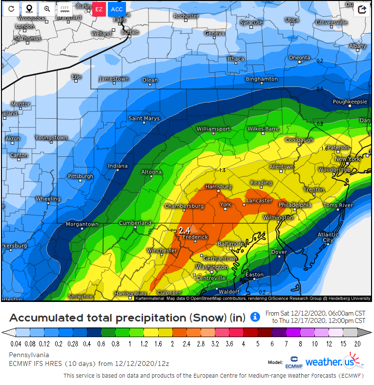
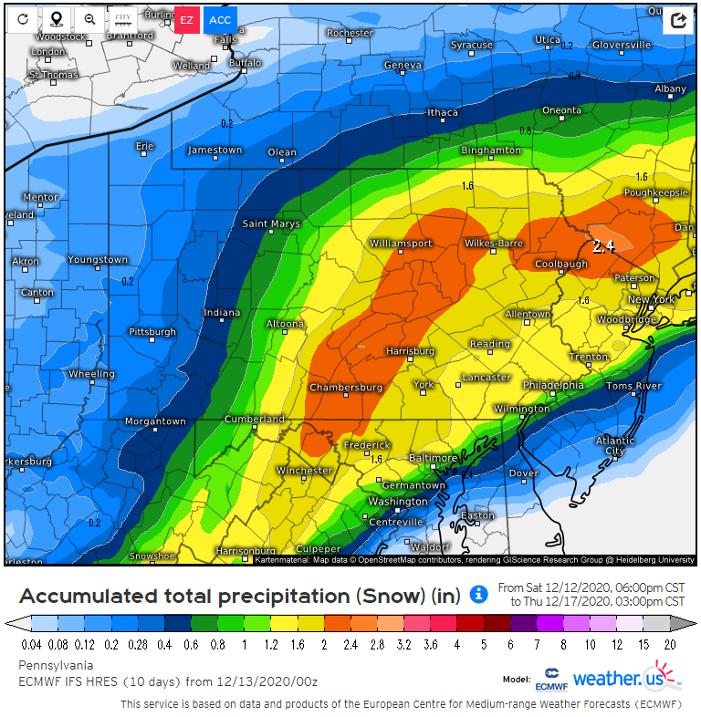
Northwest trend by the 0Z ECMWF. Slight shift, but a shift nonetheless. The 0Z update is aligning more with my idea that the snow will be north and west with mix/rain occurring in NYC.
Math23x7- Wx Statistician Guru

- Posts : 2379
Reputation : 68
Join date : 2013-01-08
 Re: DECEMBER 16th 17th 2020 Snow Threat???
Math23x7 wrote:Northwest trend by the 0Z ECMWF. Slight shift, but a shift nonetheless. The 0Z update is aligning more with my idea that the snow will be north and west with mix/rain occurring in NYC.
Thats not set in stone. GFS was east. It gave me 4 inches and now Euro gives me 19 so who knows right now. How far north and tucked does the low get before it feels the blocking and heads east is the question right now.

hyde345- Pro Enthusiast

- Posts : 1082
Reputation : 48
Join date : 2013-01-08
Location : Hyde Park, NY
 Re: DECEMBER 16th 17th 2020 Snow Threat???
hyde345 wrote:Math23x7 wrote:Northwest trend by the 0Z ECMWF. Slight shift, but a shift nonetheless. The 0Z update is aligning more with my idea that the snow will be north and west with mix/rain occurring in NYC.
Thats not set in stone. GFS was east. It gave me 4 inches and now Euro gives me 19 so who knows right now. How far north and tucked does the low get before it feels the blocking and heads east is the question right now.
12/12/20 12Z ECMWF snow totals:
12/13/20 0Z ECMWF snow totals:
Math23x7- Wx Statistician Guru

- Posts : 2379
Reputation : 68
Join date : 2013-01-08
 Re: DECEMBER 16th 17th 2020 Snow Threat???
I hope we don't rain in NYC area I'm at 17 or so on euro. Hoping to keep it there. It's been that amount or around on all the models. Hoping it doesn't go much further NW. But we will see. These wobble this far out.

jmanley32- Senior Enthusiast

- Posts : 20535
Reputation : 108
Join date : 2013-12-12
Age : 43
Location : Yonkers, NY
 Re: DECEMBER 16th 17th 2020 Snow Threat???
I hope most of you on this board end up with a blanket of snow. For myself and NJSESnowman down in ocean county NJ, we will have our fingers crossed. After Monday we should have a better grip on Wednesday pm storm, but as always the south NJ Coast always needs to watch for the sleet/rain/mix back to snow at the tale end. I'll take 1-3". More than I have had in in 2 years down here. Excited for everyone on the board and excited to track.
larryrock72- Posts : 140
Reputation : 5
Join date : 2017-01-03
Age : 52
Location : Barnegat, NJ
 Re: DECEMBER 16th 17th 2020 Snow Threat???
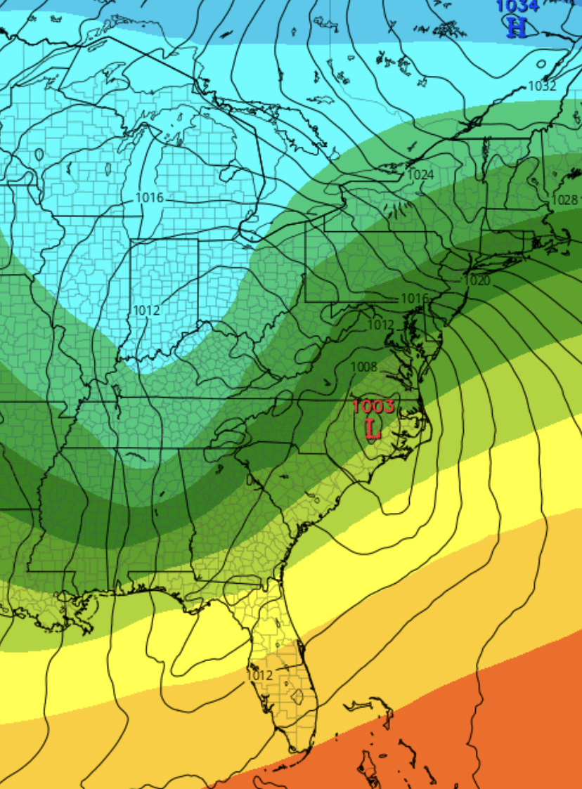
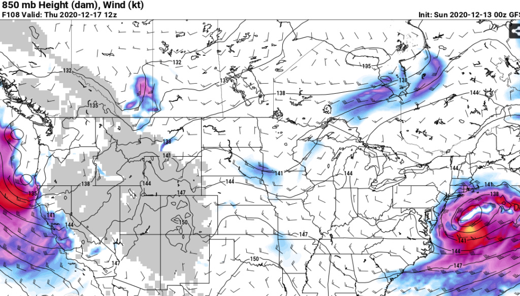
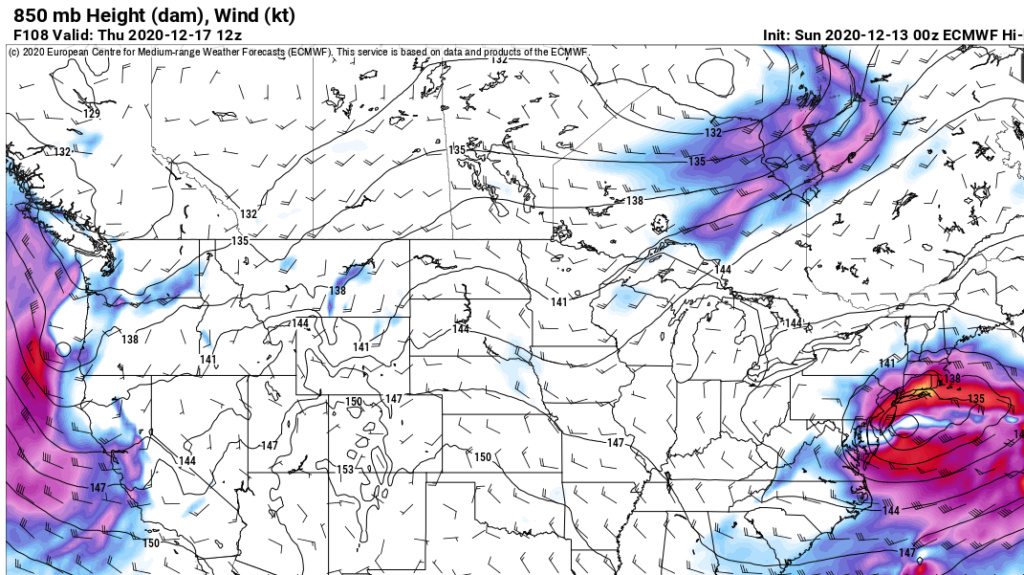
Difference in 850mb low position. Euro is too tucked IMO off Jersey because it advances the low further north. GFS is too far east IMO because it sends the low out off Delmarva. I would split the difference. But there will be a sharp cutoff with the northern extent of the precip IMO. The cold dry air will make that quite pronounced and we are not having bombing cyclogenesis to push the instability. Where that occurs is tbd.
GFS 06Z
Euro 0Z
GFS 06Z

Euro 0Z

heehaw453- Advanced Forecaster

- Posts : 3906
Reputation : 86
Join date : 2014-01-20
Location : Bedminster Township, PA Elevation 600' ASL
 Re: DECEMBER 16th 17th 2020 Snow Threat???
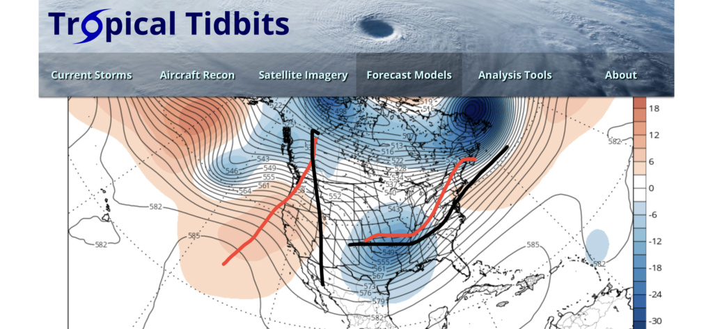
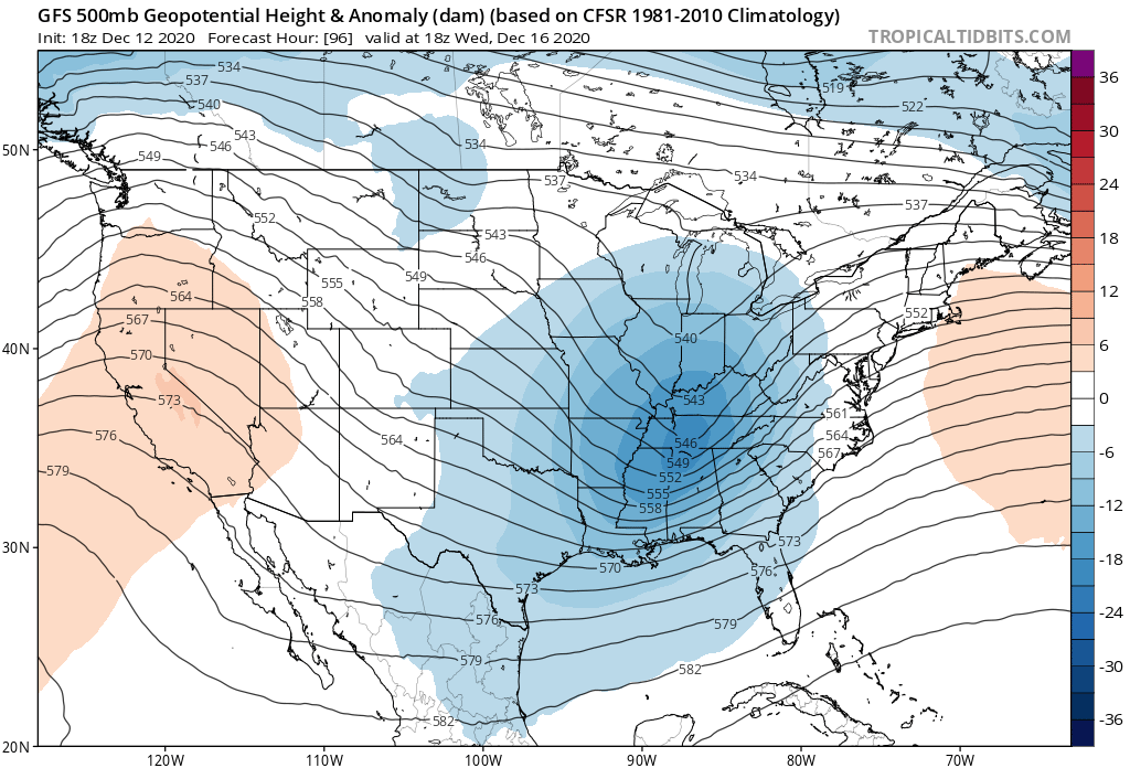
Frank_Wx wrote:rb924119 wrote:Frank_Wx wrote:If you play through individual frames of 500mb maps, you will notice models amplify the PNA ridge at just the right time for our short wave of interest. The incoming pacific short wave really deepens off the west coast and pumps the ridge to a point it helps slow the flow down through the eastern CONUS. Combined with a blocky pattern to the north, it is easy to see why models blow the storm up off the coast. That said, trends that see the ridge NOT amplify at the right time or the primary low hang on too long in the midwest - forcing the storm track a little more N&W - would lead to a much warmer track for the area. We're in a good spot...for now.
I very respectfully disagree, Frank. In the below image, the red lines indicate (left) the mean ridge position and (right) the assumed path of the H5 low in response based on relative wavelength arguments, while the black lines denote an idealize ridge axis/alignment and resulting H5 low track. Our progged western ridge location and orientation are both too far west, and the positive tilt means that there can be more height response ahead of the storm, as the storm will naturally want to start lifting out in response to added momentum on its back side.
That’s also very strange that it won’t load for you....? Maybe your setup doesn’t support .mov files?
The trough starts out positively tilted, but as the ridge goes poleward, the trough also goes neutral. I do think all of this happens late...but better late than never? The block is likely helping that.
Yes, but look at whee that ridge axis is; along the West Coast. Then, as it progresses eastward from there, it collapses, allowing the Atlantic ridge to be more dominant, which then tilts the trough further negative. Ideally, you want the ridge at maximum amplitude over the Rockies before it begins crashing, but you’re west of that here.
rb924119- Meteorologist

- Posts : 6928
Reputation : 194
Join date : 2013-02-06
Age : 32
Location : Greentown, Pa
 Re: DECEMBER 16th 17th 2020 Snow Threat???
larryrock72 wrote:I hope most of you on this board end up with a blanket of snow. For myself and NJSESnowman down in ocean county NJ, we will have our fingers crossed. After Monday we should have a better grip on Wednesday pm storm, but as always the south NJ Coast always needs to watch for the sleet/rain/mix back to snow at the tale end. I'll take 1-3". More than I have had in in 2 years down here. Excited for everyone on the board and excited to track.
I agree word for word. lol. Snow weenies in Ocean County basically live a very hit or miss lifestyle. And it’s usually a miss!! But when we thread the needle down here, it’s a lot of fun! And we get noticeably cooler temps in the summer, so for me that’s actually a high value trade off.
Within 72 hours of now casting this storm and we still got some of the more...reserved...forecasters on the board talking about us being able to thread the needle. Last year, I think we had 2.5” all year. Year before, 7-8” with a 2.5” storm high. So, we’re kinda due down here, I do believe in mean reversion as Doc says, and most importantly, we are one wobble from being in the bulls-eye...that’s actually a preferable spot to be in at this point, statistically speaking. I think. lol
Anybody else’s spouse asking why you coming to bed so late the past couple nights?
SENJsnowman- Senior Enthusiast

- Posts : 1189
Reputation : 61
Join date : 2017-01-06
Age : 51
Location : Bayville, NJ
 Re: DECEMBER 16th 17th 2020 Snow Threat???
From the sounds of what some of the more knowledgeable folks on the board it sounds like we may miss out on the big snows but not miss out entirely if what they are thinking will happen plays out. Is that correct
phil155- Pro Enthusiast

- Posts : 483
Reputation : 4
Join date : 2019-12-16
 Re: DECEMBER 16th 17th 2020 Snow Threat???
rb924119 wrote:Frank_Wx wrote:rb924119 wrote:Frank_Wx wrote:If you play through individual frames of 500mb maps, you will notice models amplify the PNA ridge at just the right time for our short wave of interest. The incoming pacific short wave really deepens off the west coast and pumps the ridge to a point it helps slow the flow down through the eastern CONUS. Combined with a blocky pattern to the north, it is easy to see why models blow the storm up off the coast. That said, trends that see the ridge NOT amplify at the right time or the primary low hang on too long in the midwest - forcing the storm track a little more N&W - would lead to a much warmer track for the area. We're in a good spot...for now.
I very respectfully disagree, Frank. In the below image, the red lines indicate (left) the mean ridge position and (right) the assumed path of the H5 low in response based on relative wavelength arguments, while the black lines denote an idealize ridge axis/alignment and resulting H5 low track. Our progged western ridge location and orientation are both too far west, and the positive tilt means that there can be more height response ahead of the storm, as the storm will naturally want to start lifting out in response to added momentum on its back side.
That’s also very strange that it won’t load for you....? Maybe your setup doesn’t support .mov files?
The trough starts out positively tilted, but as the ridge goes poleward, the trough also goes neutral. I do think all of this happens late...but better late than never? The block is likely helping that.
Yes, but look at whee that ridge axis is; along the West Coast. Then, as it progresses eastward from there, it collapses, allowing the Atlantic ridge to be more dominant, which then tilts the trough further negative. Ideally, you want the ridge at maximum amplitude over the Rockies before it begins crashing, but you’re west of that here.
I just meant there’s a period of time when the PNA ridge amplifies and it does so at an ideal
time for the southern s/w. I don’t disagree that the ridge-trough alignment is unfavorable. It’s not a pretty H5 picture. But yet, the outcome shows otherwise and that’s what we need to examine.
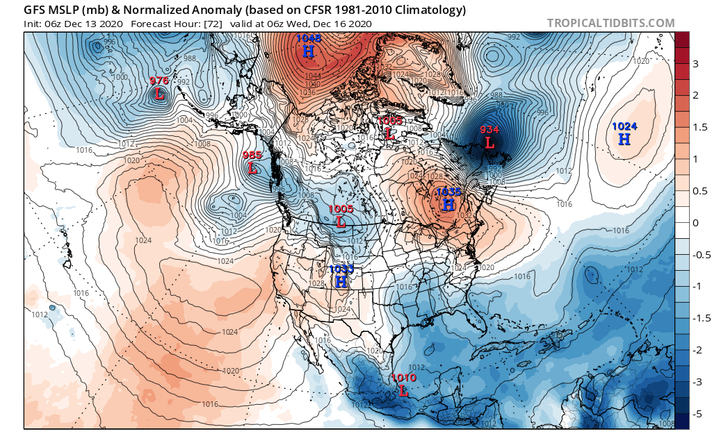
I got your video to work. You might be too caught up in the details. The 50/50 low is not technically in the 50/50 low position, you said, but that doesn’t mean it still doesn’t act like a 50/50 low would. It’s serving it’s purpose of anchoring a 1035mb HP to the north. Without the presence of the “50/50” that High with all the movement happening out west (rolling ridges and such) probably wouldn’t be there.
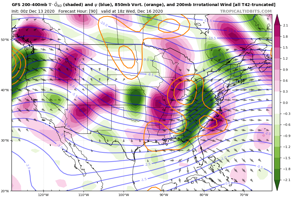

Your point about mid level low centers was a good one. If the 700, 850mb lows ends up west, we’re torched along the coast. However, again, they are also prevented from advancing too far north and end up transferring to a second low off the coast. The primary is not capable of holding on because the dynamics in the trough are hanging back a bit, likely because there is too much confluence being felt to the north.
Great video, let’s see if that’s where models trend the next couple of days. However, I’m gonna have to disagree for now!!
_________________
_______________________________________________________________________________________________________
CLICK HERE to view NJ Strong Snowstorm Classifications
 Re: DECEMBER 16th 17th 2020 Snow Threat???
_________________
_______________________________________________________________________________________________________
CLICK HERE to view NJ Strong Snowstorm Classifications
 Re: DECEMBER 16th 17th 2020 Snow Threat???
_________________
_______________________________________________________________________________________________________
CLICK HERE to view NJ Strong Snowstorm Classifications
Page 6 of 24 •  1 ... 5, 6, 7 ... 15 ... 24
Page 6 of 24
Permissions in this forum:
You cannot reply to topics in this forum|
|
|

 Home
Home

