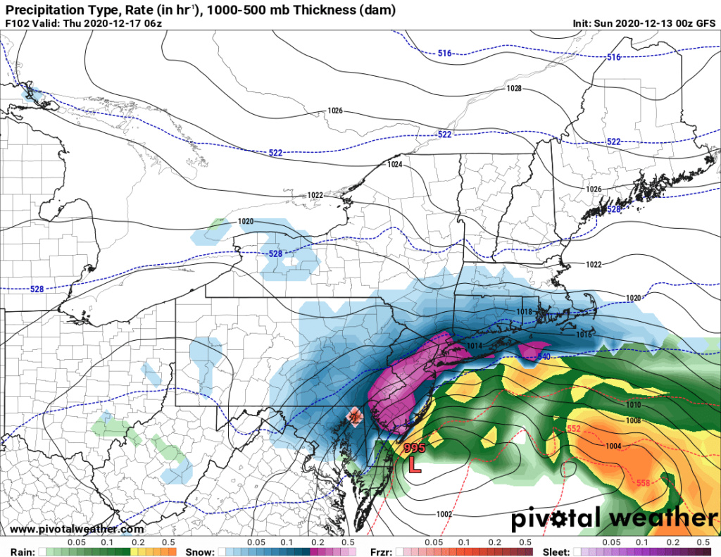
DECEMBER 16th 17th 2020 Snow Threat???
+39
SNOW MAN
snowday111
MattyICE
Nyi1058
dsix85
SENJsnowman
larryrock72
Math23x7
WeatherBob
Dunnzoo
jimv45
weatherwatchermom
Artechmetals
mmanisca
GreyBeard
SoulSingMG
CPcantmeasuresnow
hyde345
frank 638
mwilli
Frank_Wx
Radz
docstox12
phil155
skinsfan1177
bobjohnsonforthehall
adamfitz1969
rb924119
billg315
Irish
Grselig
crippo84
jmanley32
amugs
nutleyblizzard
aiannone
heehaw453
algae888
sroc4
43 posters
Page 5 of 24
Page 5 of 24 •  1, 2, 3, 4, 5, 6 ... 14 ... 24
 Re: DECEMBER 16th 17th 2020 Snow Threat???
Dunnzoo wrote:Bernie Rayno is calling for at least a foot for Bergen County, using a blend of the Euro and Canadian. He says forget the GFS and thinks the NAM will be good within 24 hours. Joe Cioffi and Joe Rao will be live on YouTube at 11 am tomorrow if anyone is interested in their take on it.
Thanks for the update Janet..Hope you enjoyed your wine yesterday! I will check out the Bernie video and I love Joe and Joe!!
weatherwatchermom- Senior Enthusiast

- Posts : 3793
Join date : 2014-11-25
 Re: DECEMBER 16th 17th 2020 Snow Threat???
jmanley32 wrote:Did he say what he expected for NYC area or is Bergen pretty close to NYC area? I always forget the counties in NJ locations. I too think that the entire area NYC metro west and east look really good atm.Dunnzoo wrote:Bernie Rayno is calling for at least a foot for Bergen County, using a blend of the Euro and Canadian. He says forget the GFS and thinks the NAM will be good within 24 hours. Joe Cioffi and Joe Rao will be live on YouTube at 11 am tomorrow if anyone is interested in their take on it.
If you cross the Tappan Zee and head south just across the border, you end up in Bergen County. We are just across the river from the Bronx. Look up Westwood on the map, that's where I am.
Dunnzoo- Senior Enthusiast - Mod

- Posts : 4904
Join date : 2013-01-11

jmanley32- Senior Enthusiast

- Posts : 20535
Reputation : 108
Join date : 2013-12-12
Age : 43
Location : Yonkers, NY
 Re: DECEMBER 16th 17th 2020 Snow Threat???
yesterday I put my snow blower up for sale(haven't used it since 2013-14)no big snowstorms since then...lol guess I'll have to stop the deal......4 now..lol
mwilli- Posts : 132
Reputation : 3
Join date : 2019-02-11
 Re: DECEMBER 16th 17th 2020 Snow Threat???
Oh sweet thats good mojo for this (sorry though), I thought you were go say you bought a new one the KOD lolmwilli wrote:yesterday I put my snow blower up for sale(haven't used it since 2013-14)no big snowstorms since then...lol guess I'll have to stop the deal......4 now..lol

jmanley32- Senior Enthusiast

- Posts : 20535
Reputation : 108
Join date : 2013-12-12
Age : 43
Location : Yonkers, NY
 Re: DECEMBER 16th 17th 2020 Snow Threat???
And some areas will probably see thundersnow! Great dynamics!
_________________
Janet
Snowfall winter of 2023-2024 17.5"
Snowfall winter of 2022-2023 6.0"
Snowfall winter of 2021-2022 17.6" 1" sleet 2/25/22
Snowfall winter of 2020-2021 51.1"
Snowfall winter of 2019-2020 8.5"
Snowfall winter of 2018-2019 25.1"
Snowfall winter of 2017-2018 51.9"
Snowfall winter of 2016-2017 45.6"
Snowfall winter of 2015-2016 29.5"
Snowfall winter of 2014-2015 50.55"
Snowfall winter of 2013-2014 66.5"
Dunnzoo- Senior Enthusiast - Mod

- Posts : 4904
Reputation : 68
Join date : 2013-01-11
Age : 62
Location : Westwood, NJ
Radz likes this post
 Re: DECEMBER 16th 17th 2020 Snow Threat???
sroc4 wrote:rb924119 wrote:sroc4 wrote:rb924119 wrote:
I’ve gotta be honest, and I’m sure this will incite riots, but unbiased opinion is that I am not impressed with this setup, and am banking on it either sliding to our south on account of a missed phase because of the secondary energy rocketing in from the Pacific, stringing out, but toppling what little transient PNA spike there will be (somebody mentioned this before, can’t recall whom, though), or, earlier phasing and it comes too far west with too much warm air to work with. Not sure which I favor yet, but I’ll have to do some more digging and revert. Either way, I strongly believe that this ends up to not be our storm.
Morning Ray. I have to respectfully disagree with your rough analysis here. I dont think we have to worry about a phase at all with this system for mid week. It looks purely southern stream to me. A southern stream system that will be running into a fresh polar air mass. As is currently being modeled a mid 1030's HP will be parked to the north in the wake of the first system that passes just south of the region late Monday, or perhaps scrapes southern portions of this boards coverage area. Def a diff set up than the one we just had.
The system that we just had had zero cold air to work with. HP to the N with that system was ragged at best in the 10 teens maybe. The freezing line at the surface was way up on, or even just N or, the Canadian boarder as indicated by the Orange line, 850's and 925mb levels were well N&W of the region as well, and the southern energy was much stronger as a cutoff low as it approached flooding the area with very warm temps from surface to mid levels ahead of the apprioaching surface Low. It did phase with N energy but the cold air was too far away and our starting point was way too warm from surface to mid levels to overcome an actually favorable surface low, 850 and 500mb closed low track to bring temps down fast enough.
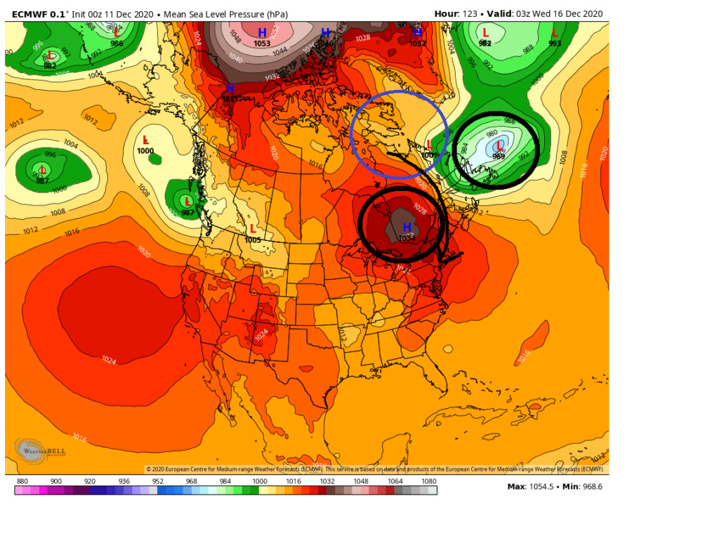
Not the case in this set up. As you can see the air mass on Tuesday, compliments of the early week system has surface temps from single digits to teens and 20's knocking on the door(black circle)with even most of the coastal plain starting in the mid to upper 30's. More than cold enough, esp with the HP where it is to draw from a cold enough source region. Meanwhile Tuesday ahead of the system the 925-850mb temps are well below freezing as the system approaches again compliments of our fresh injection of a polar air mass. Not that Im looking at these details with any merit just yet but even dew points look great thus far in modeling out ahead of the system, not the case with the last one.
In addition the first system seesm to create a kind of pseudo 50/50 low. Combined with the PNA region out west its just enough to force the track no further west than a coastal hugger worst case scenario IMHO. I can def see a swing and miss to the SE however if the cold air pushes to hard.
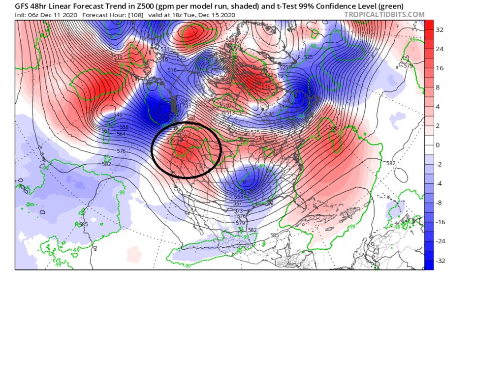
Reagrding the PNA ridge GFS trend forecast(euro is modeled very similar in its timing and strength as well currently) has the 500mb forecast trending stronger In the NW CONUS right as our surface LP is coming off the EC. If true the timing of the ridging is such that combined with the HP parked to the N, a pseudo 50/50 LP and the ridge going up instead of on its way down you get a trajectory NE and a track to the SE of LI somehwhere towards the BM. NW of or SE of yet to be determined. However if the timing of the ridge out west isnt modeled correctly then the track of the LP may flatten out and hence the more ENE track and miss to our SE.
Obv still a LOOOONNGGG way to go with this one, but getting the HP set up to the N is step one to the equation which is looking more and more likely. Flooding the area with warm is is becoming less and less likely. Dont get me wrong the coastal plain may still rain or mix if LP track is tucked in, but overall this set up is leaps and bounds better than the last.
WE TRACK!!!!
Hey Scott!
I posted this last night elsewhere in response to another poster questioning why I am not enthused with this setup, and it basically discusses my overarching ideas. Two additional things to counter you here, though: Without the presence of a 70/70 ridge, this works to establish a waveguide that is out of synch for a favorably located trough in the east, which is supported by a mean ridge axis that is OFF the west coast. Ideally, we want to see a well-developed poleward ridge axis over Boise, Idaho. Now, we will have a pseudo ridge, but this is already in the process of deamplifying and becoming positively tilted in response to a surge of momentum and energy streaming in from the Pacific. As this flattens, heights should begin to respond accordingly downstream by rising, in coordination with the below discussion.
I hope the below demonstrates my points well, and I agree that the setup is better, but just honestly don’t think it’s good enough and will end up to be too warm/west for us to really cash in on any substantial totals. I think those will be saved for folks north of 80-84 and west of 81. Regardless, it’s still worth tracking :p
“In this image, I have a few different things quickly and approximately annotated just to try to demonstrate my broader points: our storm of interest is the red "L", our progged evolving surface high pressure (based on basic dynamics of H5, not surface maps) denoted by the two blue "H" enclosed by the blue circle, the outline of what is being referenced as a 50/50 low (which it's actually further northwest than we would like) as well as a second phasing trough, which is Monday's energy, a weakness in the North Atlantic ridging/void in the northern mid-latitude flow in purple, and an idealized surface high pressure in yellow (I'll get to the red arrow shortly). Just looking at these annotations and disregarding the rest of the hemisphere for a moment, you can see that our surface high pressure that initially starts to our northeast becomes contaminated with maritime polar air, thanks to Monday's energy allowing a secondary area of high pressure to slip off the East Coast ahead of the storm of interest. When you consider isallobaric and density components, this will begin imparting an effectual easterly "component" to the low-level and thermal flow, thereby moderating any true arctic component from the northern stream high. Secondly, because of the weakness that is created in response to the phasing of the displaced 50/50 low and Monday's energy beneath blocking that is a bit too far poleward, the phasing energies are forced to slip eastward beneath the block. As they do, they take our surface highs with them, and therefore, the proximity to our lone truly arctic low-level dome decreases as it shifts northeastward behind the departing phasing troughs. Then, as return flow increases in their wake, ridging begins to build behind them (red arrow).
Now, when you consider the rest of the hemispheric and tropical factors, such as the lack of a 70/70 ridge, a truly negative EPO/WPO(for this quick and dirty rebuttal I will consider them as neutral), a truly positive, and well oriented PNA (again, considering this as neutral), and unfavorable tropical forcings combined with anomalously warm Atlantic and Caribbean waters, to me we should see this overall pattern retract toward the pole a bit, thereby allowing everything to shift north (favorable confluence/low-level cold dome, 50/50 low, Atlantic ridge). As a result, then, it would stand to reason that a less favorable storm track and/or airmass becomes more likely than it appears right now in the modeling.
Again, I want to stress that these are quickly put together, general thoughts based on what I've been able to follow and the map in question, and my preliminary post highlighted my underlying uncertainties regarding the eventual outcome. But, this is how I am broadly looking at this.”
I freaking love it Ray. Some really good stuff here. And I follow along completely. There is actually several points that you have forced me to re-examine because I had not thought of.
At this point we are still too far out for me to look at individual model runs today(although IMBY loves the 12z GFS) and change my mind or further solidify my current thinking because there is simply still too much difference between GFS and Euro at H5 in some of the key features we are discussing. Esp in regards to the PNA region.
One aspect that I had not thought about is the HP building in the Atlantic leading to an easterly component just ahead of the system. My thoughts on that are this. While I will definetely agree there will be an easterly vector in the winds as a result of this I still believe the strongest vectors come from the NNE, N and NW and because so and because the cold air is already in place the sum of the vectors from the colder directions will over come, and LP to the north is still in "good enough" position to our north upon system sLP arrival, making it too difficult to scour out the dense cold air in place. Its not like the HP is building NW off a stronger pressing WAR. Its a HP building SE from an arctic/Polar HP. A decently strong one at that. Again this is the thoughts for now.
I think we have our lines drawn for now. lol Lets see what trends occur over the next 24-24. I love the discussion
"Thanks, Scott, and I must say that it's nice just to be able to have a civilized discussion with somebody, rather than just be mocked and dismissed like I have been repeatedly over on 33, in spite of coming out on top of multiple forecasts. Long story short, I'm done over there after this event. You can glean a lot of information over there, I'll admit, but the favoritism and group think has become terrible, and I now understand why Tom left (as well as others). So, that said, you'll probably be seeing more of me over here from now on haha Now, onto the meat and potatoes. I certainly see your point regarding the lower level high pressure/cold dome, and its valid. Essentially, you're banking on the blocking "50/50" (in quotes because it's not exact, as you alluded to with "good enough position") holding in long enough so that the northern stream high remains suppressed (with reference to latitudinal displacement) long enough to maintain the flow of true arctic air and overwhelm any influence from the Atlantic. And that is (I think), up to this point, the only point of divergence between us.
HOWEVER, I have noticed something else today in my musings and observations of today's suites, which I will now discuss (just renewed my AccuWeather Pro subscription, so like a shiny new toy, I'm just itching to use it haha). In my opinion, I think the models, ALL models, are focusing on the wrong low-level center, at least in the early stages of development, and actually think that we *should* see a re-emergence of the primary low holding on longer in future runs. This would fall in line with my previous discussion, and allow for a further northwest/warmer evolution. I was going to do a write up, but there's so much that I want to say, I figured a video would be better (will be posted separately once it's ready). I hope you all enjoy it!!"
--------------------------------------------------------------------------
Piggy-backing off of the above, please find the link to my video discussion of this threat below. First, it's a bit lengthy, clocking in at just under 30 minutes, so I apologize in advance for that, but I'm quite rusty, and I really did not want to try recutting it three, four, or five times lol So, it's probably a bit less refined than my previous ones, but hopefully I'll be able to shake the rust off in fairly short order haha
That said, this discussion was based off of what I had been able to follow up to the 12z suite yesterday, and my analysis is based on the 12z suites. For those interested, I hope that you enjoy it and that it makes sense, but as usual, if you have any questions, comments or concerns, I welcome the discussion!
https://drive.google.com/file/d/1efJNFVge-eqz6jJkc3zmYd6NpUPRl_bD/view?usp=sharing
Ooh, side note, I fully understand that I am in the "nearly non-existent" category in terms of expected outcomes, and modeling is much more enthusiastic than I am. However, my goal is to be better than the models, so from that perspective, I hope that I end up to be correct in the end. From the weenie perspective, well, it pained me. But I try to be as objective as I can and just get it right more than anything........WE TRACK!!
rb924119- Meteorologist

- Posts : 6928
Reputation : 194
Join date : 2013-02-06
Age : 32
Location : Greentown, Pa
 Re: DECEMBER 16th 17th 2020 Snow Threat???
jmanley32 wrote:Oh sweet thats good mojo for this (sorry though), I thought you were go say you bought a new one the KOD lolmwilli wrote:yesterday I put my snow blower up for sale(haven't used it since 2013-14)no big snowstorms since then...lol guess I'll have to stop the deal......4 now..lol
That was my mistake last year. Bought one in early December. So 2019 is my fault unfortunately.
Sorry everyone.

bobjohnsonforthehall- Posts : 311
Reputation : 19
Join date : 2016-10-02
Location : Flemington NJ
 Re: DECEMBER 16th 17th 2020 Snow Threat???
Oh that would be so cool! I only saw it once when I was a kid, did not know about it scared the hell out of me. I would react similar to Cantore lol except I would rather win powerball LOLDunnzoo wrote:And some areas will probably see thundersnow! Great dynamics!

jmanley32- Senior Enthusiast

- Posts : 20535
Reputation : 108
Join date : 2013-12-12
Age : 43
Location : Yonkers, NY
 Re: DECEMBER 16th 17th 2020 Snow Threat???
[quote="rb924119"][quote="sroc4"][quote="rb924119"][quote="sroc4"]
Thanks for this, makes sense to me, my question is, when do you think the models might adjust to this and will we see a strengthening WAR? Do you think we will see any adjusting tomorrow, or will it be within 48 hours of the event?
rb924119 wrote:
HOWEVER, I have noticed something else today in my musings and observations of today's suites, which I will now discuss (just renewed my AccuWeather Pro subscription, so like a shiny new toy, I'm just itching to use it haha). In my opinion, I think the models, ALL models, are focusing on the wrong low-level center, at least in the early stages of development, and actually think that we *should* see a re-emergence of the primary low holding on longer in future runs. This would fall in line with my previous discussion, and allow for a further northwest/warmer evolution. I was going to do a write up, but there's so much that I want to say, I figured a video would be better (will be posted separately once it's ready). I hope you all enjoy it!!"
--------------------------------------------------------------------------
Piggy-backing off of the above, please find the link to my video discussion of this threat below. First, it's a bit lengthy, clocking in at just under 30 minutes, so I apologize in advance for that, but I'm quite rusty, and I really did not want to try recutting it three, four, or five times lol So, it's probably a bit less refined than my previous ones, but hopefully I'll be able to shake the rust off in fairly short order haha
That said, this discussion was based off of what I had been able to follow up to the 12z suite yesterday, and my analysis is based on the 12z suites. For those interested, I hope that you enjoy it and that it makes sense, but as usual, if you have any questions, comments or concerns, I welcome the discussion!Enjoy!!
https://drive.google.com/file/d/1efJNFVge-eqz6jJkc3zmYd6NpUPRl_bD/view?usp=sharing
Ooh, side note, I fully understand that I am in the "nearly non-existent" category in terms of expected outcomes, and modeling is much more enthusiastic than I am. However, my goal is to be better than the models, so from that perspective, I hope that I end up to be correct in the end. From the weenie perspective, well, it pained me. But I try to be as objective as I can and just get it right more than anything........WE TRACK!!
Thanks for this, makes sense to me, my question is, when do you think the models might adjust to this and will we see a strengthening WAR? Do you think we will see any adjusting tomorrow, or will it be within 48 hours of the event?
_________________
Janet
Snowfall winter of 2023-2024 17.5"
Snowfall winter of 2022-2023 6.0"
Snowfall winter of 2021-2022 17.6" 1" sleet 2/25/22
Snowfall winter of 2020-2021 51.1"
Snowfall winter of 2019-2020 8.5"
Snowfall winter of 2018-2019 25.1"
Snowfall winter of 2017-2018 51.9"
Snowfall winter of 2016-2017 45.6"
Snowfall winter of 2015-2016 29.5"
Snowfall winter of 2014-2015 50.55"
Snowfall winter of 2013-2014 66.5"

Dunnzoo- Senior Enthusiast - Mod

- Posts : 4904
Reputation : 68
Join date : 2013-01-11
Age : 62
Location : Westwood, NJ
 Re: DECEMBER 16th 17th 2020 Snow Threat???
Bernie Rayno video about where he thinks right now area of heaviest snow will be. Uses a blend of CMC and Euro upper low track. Makes sense.
https://www.pscp.tv/AccuRayno/1nAJELjXwORGL
https://www.pscp.tv/AccuRayno/1nAJELjXwORGL

hyde345- Pro Enthusiast

- Posts : 1082
Reputation : 48
Join date : 2013-01-08
Location : Hyde Park, NY
 Re: DECEMBER 16th 17th 2020 Snow Threat???
[/quote]Dunnzoo wrote:
Thanks for this, makes sense to me, my question is, when do you think the models might adjust to this and will we see a strengthening WAR? Do you think we will see any adjusting tomorrow, or will it be within 48 hours of the event?
I would argue that we have already been seeing these adjustments in the height field, as the trough has generally trended sharper beneath the confluent flow, which it wouldn’t otherwise do with a generally flatter PNA domain unless it was running into resistance ahead of it. This is further evidenced by a steady enhancement of the height anomalies out ahead of it.
rb924119- Meteorologist

- Posts : 6928
Reputation : 194
Join date : 2013-02-06
Age : 32
Location : Greentown, Pa
 Re: DECEMBER 16th 17th 2020 Snow Threat???
Dunnzoo wrote:jmanley32 wrote:Did he say what he expected for NYC area or is Bergen pretty close to NYC area? I always forget the counties in NJ locations. I too think that the entire area NYC metro west and east look really good atm.Dunnzoo wrote:Bernie Rayno is calling for at least a foot for Bergen County, using a blend of the Euro and Canadian. He says forget the GFS and thinks the NAM will be good within 24 hours. Joe Cioffi and Joe Rao will be live on YouTube at 11 am tomorrow if anyone is interested in their take on it.
If you cross the Tappan Zee and head south just across the border, you end up in Bergen County. We are just across the river from the Bronx. Look up Westwood on the map, that's where I am.
Thank you for calling it the Tappan Zee. Still pissed off that ego maniac named a bridge after his father, and by decree no less. Though he loathes Trump, he has more in common with him than he realizes.
Sorry I'm done for the season, had to let it out. It's your fault Janet.

CPcantmeasuresnow- Wx Statistician Guru

- Posts : 7274
Reputation : 230
Join date : 2013-01-07
Age : 103
Location : Eastern Orange County, NY
 Re: DECEMBER 16th 17th 2020 Snow Threat???
Ray - your video will not load for some reason, but I do agree with your concern that models may be killing off the primary low too quickly and focusing on the secondary. That said, given the confluence to the north, my guess is the primary low would transfer energy to a secondary low off the coast. Perhaps, we will begin seeing models trend toward more of a Miller B than Miller A style storm. I think the PNA ridge amplifies at JUST the right time, because if the flow out west stayed zonal, we probably wouldnt be following a large scale event as H5 energy would end up not phasing.
_________________
_______________________________________________________________________________________________________
CLICK HERE to view NJ Strong Snowstorm Classifications
 Re: DECEMBER 16th 17th 2020 Snow Threat???
Frank_Wx wrote:Ray - your video will not load for some reason, but I do agree with your concern that models may be killing off the primary low too quickly and focusing on the secondary. That said, given the confluence to the north, my guess is the primary low would transfer energy to a secondary low off the coast. Perhaps, we will begin seeing models trend toward more of a Miller B than Miller A style storm. I think the PNA ridge amplifies at JUST the right time, because if the flow out west stayed zonal, we probably wouldnt be following a large scale event as H5 energy would end up not phasing.
https://drive.google.com/file/d/1efJNFVge-eqz6jJkc3zmYd6NpUPRl_bD/view
Does that work?
I agree that a secondary will HAVE to develop, I just think it will be a bit later and/or further west when it does. I also agree that there is much more meridional flow to start, however, as our system continues moving eastward, I believe that the trailing ridge will be too flat to compensate for the burgeoning ridging out ahead of the storm, and so the storm will begin wrapping up and take more of a northeasterly trajectory rather than an east-northeast trajectory. This would put the mid-level lows essentially overhead, which would flood our low and mid-levels with warmth and lead to an ugly dry slot, with the best snowfall northwest into central Pa and NY State.
Also, the mean ridge axis is off the west coast as our initial trailing ridge folds over, which would also support a further west track, in my opinion.
rb924119- Meteorologist

- Posts : 6928
Reputation : 194
Join date : 2013-02-06
Age : 32
Location : Greentown, Pa
 Re: DECEMBER 16th 17th 2020 Snow Threat???
Def not what any of us want to hear but if thats what happens hats off to you.rb924119 wrote:Frank_Wx wrote:Ray - your video will not load for some reason, but I do agree with your concern that models may be killing off the primary low too quickly and focusing on the secondary. That said, given the confluence to the north, my guess is the primary low would transfer energy to a secondary low off the coast. Perhaps, we will begin seeing models trend toward more of a Miller B than Miller A style storm. I think the PNA ridge amplifies at JUST the right time, because if the flow out west stayed zonal, we probably wouldnt be following a large scale event as H5 energy would end up not phasing.
https://drive.google.com/file/d/1efJNFVge-eqz6jJkc3zmYd6NpUPRl_bD/view
Does that work?
I agree that a secondary will HAVE to develop, I just think it will be a bit later and/or further west when it does. I also agree that there is much more meridional flow to start, however, as our system continues moving eastward, I believe that the trailing ridge will be too flat to compensate for the burgeoning ridging out ahead of the storm, and so the storm will begin wrapping up and take more of a northeasterly trajectory rather than an east-northeast trajectory. This would put the mid-level lows essentially overhead, which would flood our low and mid-levels with warmth and lead to an ugly dry slot, with the best snowfall northwest into central Pa and NY State.
Also, the mean ridge axis is off the west coast as our initial trailing ridge folds over, which would also support a further west track, in my opinion.

jmanley32- Senior Enthusiast

- Posts : 20535
Reputation : 108
Join date : 2013-12-12
Age : 43
Location : Yonkers, NY
 Re: DECEMBER 16th 17th 2020 Snow Threat???
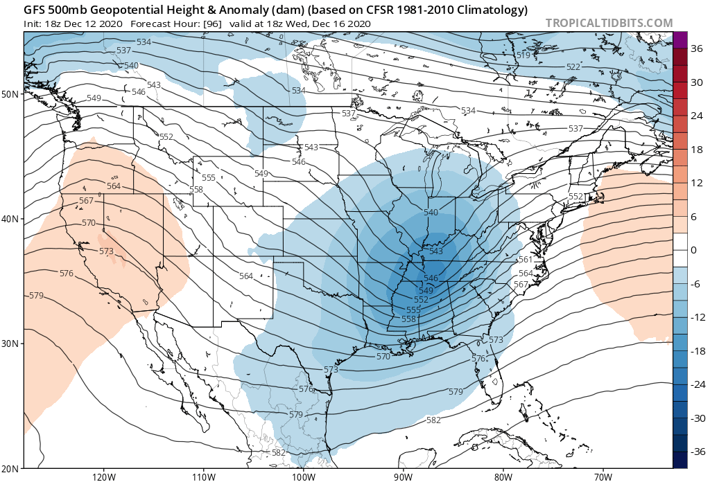
If you play through individual frames of 500mb maps, you will notice models amplify the PNA ridge at just the right time for our short wave of interest. The incoming pacific short wave really deepens off the west coast and pumps the ridge to a point it helps slow the flow down through the eastern CONUS. Combined with a blocky pattern to the north, it is easy to see why models blow the storm up off the coast. That said, trends that see the ridge NOT amplify at the right time or the primary low hang on too long in the midwest - forcing the storm track a little more N&W - would lead to a much warmer track for the area. We're in a good spot...for now.


_________________
_______________________________________________________________________________________________________
CLICK HERE to view NJ Strong Snowstorm Classifications
 Re: DECEMBER 16th 17th 2020 Snow Threat???
rb924119 wrote:Frank_Wx wrote:Ray - your video will not load for some reason, but I do agree with your concern that models may be killing off the primary low too quickly and focusing on the secondary. That said, given the confluence to the north, my guess is the primary low would transfer energy to a secondary low off the coast. Perhaps, we will begin seeing models trend toward more of a Miller B than Miller A style storm. I think the PNA ridge amplifies at JUST the right time, because if the flow out west stayed zonal, we probably wouldnt be following a large scale event as H5 energy would end up not phasing.
https://drive.google.com/file/d/1efJNFVge-eqz6jJkc3zmYd6NpUPRl_bD/view
Does that work?
I agree that a secondary will HAVE to develop, I just think it will be a bit later and/or further west when it does. I also agree that there is much more meridional flow to start, however, as our system continues moving eastward, I believe that the trailing ridge will be too flat to compensate for the burgeoning ridging out ahead of the storm, and so the storm will begin wrapping up and take more of a northeasterly trajectory rather than an east-northeast trajectory. This would put the mid-level lows essentially overhead, which would flood our low and mid-levels with warmth and lead to an ugly dry slot, with the best snowfall northwest into central Pa and NY State.
Also, the mean ridge axis is off the west coast as our initial trailing ridge folds over, which would also support a further west track, in my opinion.
It stays on the loading screen. I will try on my phone and see if it works.

_________________
_______________________________________________________________________________________________________
CLICK HERE to view NJ Strong Snowstorm Classifications
 Re: DECEMBER 16th 17th 2020 Snow Threat???
Frank_Wx wrote:If you play through individual frames of 500mb maps, you will notice models amplify the PNA ridge at just the right time for our short wave of interest. The incoming pacific short wave really deepens off the west coast and pumps the ridge to a point it helps slow the flow down through the eastern CONUS. Combined with a blocky pattern to the north, it is easy to see why models blow the storm up off the coast. That said, trends that see the ridge NOT amplify at the right time or the primary low hang on too long in the midwest - forcing the storm track a little more N&W - would lead to a much warmer track for the area. We're in a good spot...for now.
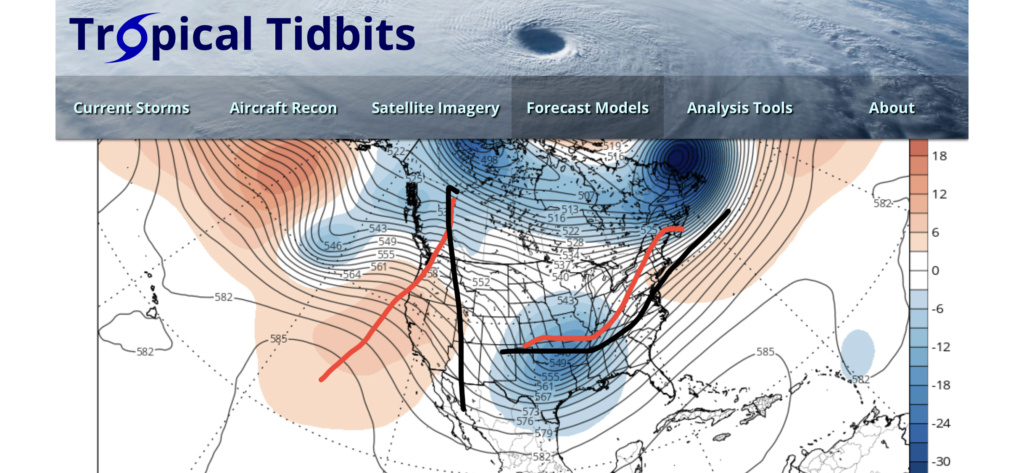
I very respectfully disagree, Frank. In the below image, the red lines indicate (left) the mean ridge position and (right) the assumed path of the H5 low in response based on relative wavelength arguments, while the black lines denote an idealize ridge axis/alignment and resulting H5 low track. Our progged western ridge location and orientation are both too far west, and the positive tilt means that there can be more height response ahead of the storm, as the storm will naturally want to start lifting out in response to added momentum on its back side.
That’s also very strange that it won’t load for you....? Maybe your setup doesn’t support .mov files?
rb924119- Meteorologist

- Posts : 6928
Reputation : 194
Join date : 2013-02-06
Age : 32
Location : Greentown, Pa
 Re: DECEMBER 16th 17th 2020 Snow Threat???
rb924119 wrote:Frank_Wx wrote:If you play through individual frames of 500mb maps, you will notice models amplify the PNA ridge at just the right time for our short wave of interest. The incoming pacific short wave really deepens off the west coast and pumps the ridge to a point it helps slow the flow down through the eastern CONUS. Combined with a blocky pattern to the north, it is easy to see why models blow the storm up off the coast. That said, trends that see the ridge NOT amplify at the right time or the primary low hang on too long in the midwest - forcing the storm track a little more N&W - would lead to a much warmer track for the area. We're in a good spot...for now.
I very respectfully disagree, Frank. In the below image, the red lines indicate (left) the mean ridge position and (right) the assumed path of the H5 low in response based on relative wavelength arguments, while the black lines denote an idealize ridge axis/alignment and resulting H5 low track. Our progged western ridge location and orientation are both too far west, and the positive tilt means that there can be more height response ahead of the storm, as the storm will naturally want to start lifting out in response to added momentum on its back side.
That’s also very strange that it won’t load for you....? Maybe your setup doesn’t support .mov files?
The trough starts out positively tilted, but as the ridge goes poleward, the trough also goes neutral. I do think all of this happens late...but better late than never? The block is likely helping that.
_________________
_______________________________________________________________________________________________________
CLICK HERE to view NJ Strong Snowstorm Classifications
 Re: DECEMBER 16th 17th 2020 Snow Threat???
Just looked at the updated forecast on weather.com and even though the predicted snow totals are 9-18 inches, the high temps are creeping up, which makes me nervous about the fear that warm air might get in.

Irish- Pro Enthusiast

- Posts : 788
Reputation : 19
Join date : 2019-01-16
Age : 45
Location : Old Bridge, NJ
 Re: DECEMBER 16th 17th 2020 Snow Threat???
This may have been answered but is this turning into a thread the needle event? Between Frank, scotts and rb's discussions I do not know what to think lol

jmanley32- Senior Enthusiast

- Posts : 20535
Reputation : 108
Join date : 2013-12-12
Age : 43
Location : Yonkers, NY
 Re: DECEMBER 16th 17th 2020 Snow Threat???
jmanley32 wrote:This may have been answered but is this turning into a thread the needle event? Between Frank, scotts and rb's discussions I do not know what to think lol
Neither of us truly know. We’re just participating in casual discourse and playing devil’s advocate. Up to the readers to decide on their own who has the better argument and what their gut tells them
_________________
_______________________________________________________________________________________________________
CLICK HERE to view NJ Strong Snowstorm Classifications
 Re: DECEMBER 16th 17th 2020 Snow Threat???
Irish wrote:Just looked at the updated forecast on weather.com and even though the predicted snow totals are 9-18 inches, the high temps are creeping up, which makes me nervous about the fear that warm air might get in.
Temp forecasts are meaningless until within 48 hours
_________________
_______________________________________________________________________________________________________
CLICK HERE to view NJ Strong Snowstorm Classifications
 Re: DECEMBER 16th 17th 2020 Snow Threat???
_________________
_______________________________________________________________________________________________________
CLICK HERE to view NJ Strong Snowstorm Classifications
 Re: DECEMBER 16th 17th 2020 Snow Threat???
_________________
_______________________________________________________________________________________________________
CLICK HERE to view NJ Strong Snowstorm Classifications
 Re: DECEMBER 16th 17th 2020 Snow Threat???
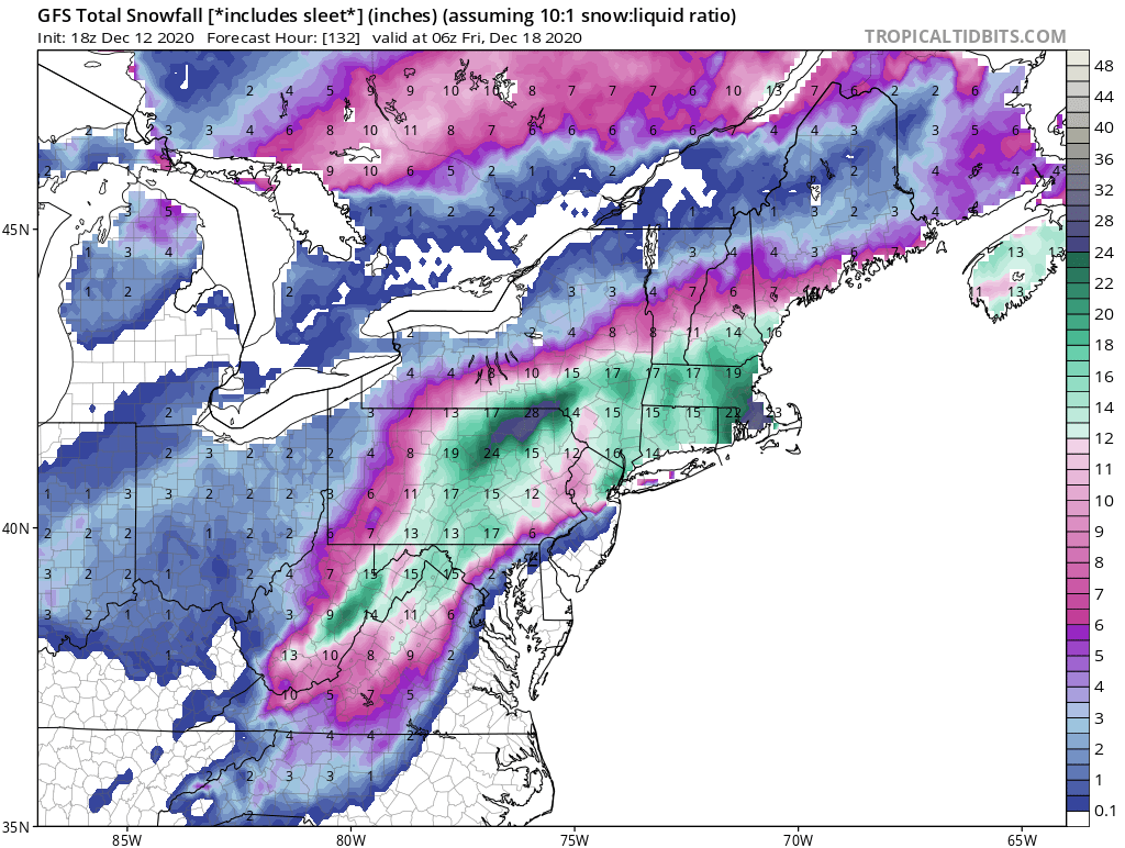
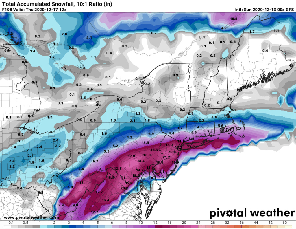
0z GFS is prodigious snow amounts I80 on south. The run had the storm further east and a bit strong than 18Z. As a result more snow towards coast.
Shows similar evolution of the storm getting kicked east instead of ENE due to block. I think they'll be some back on forth on this but at the end of the day it'll probably do the ENE thing. SNE is max far north of the threat area IMO. This is not riding up the coast to the Canadian Maritimes.
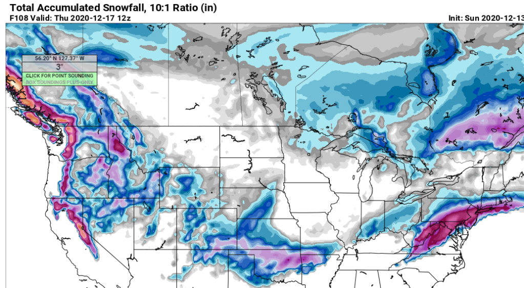
Shows similar evolution of the storm getting kicked east instead of ENE due to block. I think they'll be some back on forth on this but at the end of the day it'll probably do the ENE thing. SNE is max far north of the threat area IMO. This is not riding up the coast to the Canadian Maritimes.

heehaw453- Advanced Forecaster

- Posts : 3906
Reputation : 86
Join date : 2014-01-20
Location : Bedminster Township, PA Elevation 600' ASL
Page 5 of 24 •  1, 2, 3, 4, 5, 6 ... 14 ... 24
Page 5 of 24
Permissions in this forum:
You cannot reply to topics in this forum|
|
|

 Home
Home