
 Search
Tropical Storm HENRI: Discussions and Observations
Page 3 of 3 •  1, 2, 3
Re: Tropical Storm HENRI: Discussions and Observations
![]() by jmanley32 Sun Aug 22, 2021 9:36 pm
by jmanley32 Sun Aug 22, 2021 9:36 pm
your in throggs neck? my sister in law lives on bradford, do you know where that is?frank 638 wrote:also another strange thing Where I am in throggs neck One area looking towards the bridge and queens I noticed it was partly cloudy and for me where I live looking over north west dark clouds and rain I never seen this before esp that last for a long time and still continue to rain not heavy just light .This was one strange stormjmanley32 wrote:for some reason not all of them came as a EAS alert on my phone. looks like the rain is moving west from nyc now but will head back east overnight. aint that some stuff, you cant make this up!!frank 638 wrote:U got that right since last night my phone is been going off with the flash flood warning
jmanley32- Senior Enthusiast

- Posts : 20513
Join date : 2013-12-12
Re: Tropical Storm HENRI: Discussions and Observations
![]() by essexcountypete Sun Aug 22, 2021 9:41 pm
by essexcountypete Sun Aug 22, 2021 9:41 pm
frank 638 wrote:also another strange thing Where I am in throggs neck One area looking towards the bridge and queens I noticed it was partly cloudy and for me where I live looking over north west dark clouds and rain I never seen this before esp that last for a long time and still continue to rain not heavy just light .This was one strange stormjmanley32 wrote:for some reason not all of them came as a EAS alert on my phone. looks like the rain is moving west from nyc now but will head back east overnight. aint that some stuff, you cant make this up!!frank 638 wrote:U got that right since last night my phone is been going off with the flash flood warning
I can see what you're talking about on radar. You're right on the edge of the moisture.
essexcountypete- Pro Enthusiast

- Posts : 783
Join date : 2013-12-09
Re: Tropical Storm HENRI: Discussions and Observations
![]() by amugs Sun Aug 22, 2021 10:49 pm
by amugs Sun Aug 22, 2021 10:49 pm
_________________
Mugs
AKA:King: Snow Weenie
Self Proclaimed
WINTER 2014-15 : 55.12" +.02 for 6 coatings (avg. 35")
WINTER 2015-16 Total - 29.8" (Avg 35")
WINTER 2016-17 : 39.5" so far

amugs- Advanced Forecaster - Mod

- Posts : 15093
Reputation : 213
Join date : 2013-01-07
Age : 54
Location : Hillsdale,NJ
Re: Tropical Storm HENRI: Discussions and Observations
![]() by amugs Sun Aug 22, 2021 10:51 pm
by amugs Sun Aug 22, 2021 10:51 pm

Jesus up 6" more possibly and 8" for other areas as outlined. This is insane
_________________
Mugs
AKA:King: Snow Weenie
Self Proclaimed
WINTER 2014-15 : 55.12" +.02 for 6 coatings (avg. 35")
WINTER 2015-16 Total - 29.8" (Avg 35")
WINTER 2016-17 : 39.5" so far
amugs- Advanced Forecaster - Mod
- Posts : 15093
Reputation : 213
Join date : 2013-01-07
Age : 54
Location : Hillsdale,NJ
Re: Tropical Storm HENRI: Discussions and Observations
![]() by frank 638 Mon Aug 23, 2021 6:45 am
by frank 638 Mon Aug 23, 2021 6:45 am
frank 638- Senior Enthusiast
- Posts : 2824
Reputation : 37
Join date : 2016-01-01
Age : 40
Location : bronx ny
Re: Tropical Storm HENRI: Discussions and Observations
![]() by sroc4 Mon Aug 23, 2021 7:40 am
by sroc4 Mon Aug 23, 2021 7:40 am
https://en.wikipedia.org/wiki/Fujiwhara_effect
The Fujiwhara effect, sometimes referred to as the Fujiwara effect, Fujiw(h)ara interaction or binary interaction, is a phenomenon that occurs when two nearby cyclonic vortices move around each other and close the distance between the circulations of their corresponding low-pressure areas. The effect is named after Sakuhei Fujiwhara, the Japanese meteorologist who initially described the effect. Binary interaction of smaller circulations can cause the development of a larger cyclone, or cause two cyclones to merge into one. Extratropical cyclones typically engage in binary interaction when within 2,000 kilometres (1,200 mi) of one another, while tropical cyclones typically interact within 1,400 kilometres (870 mi) of each other.

Look at how the cutoff low captures Henri, they then pivot around one another until they become one entity, remain stationary for a brief time as they remain cutoff from the mean flow, and then eventually the new ULL(combined Henri and the original ULL) get picked up and finally carried away. Def a crazy set up to say the least.


_________________
"In weather and in life, there's no winning and losing; there's only winning and learning."
WINTER 2012/2013 TOTALS 43.65"WINTER 2017/2018 TOTALS 62.85" WINTER 2022/2023 TOTALS 4.9"
WINTER 2013/2014 TOTALS 64.85"WINTER 2018/2019 TOTALS 14.25" WINTER 2023/2024 TOTALS 13.1"
WINTER 2014/2015 TOTALS 71.20"WINTER 2019/2020 TOTALS 6.35"
WINTER 2015/2016 TOTALS 35.00"WINTER 2020/2021 TOTALS 37.75"
WINTER 2016/2017 TOTALS 42.25"WINTER 2021/2022 TOTALS 31.65"

sroc4- Admin

- Posts : 8331
Reputation : 301
Join date : 2013-01-07
Location : Wading River, LI
essexcountypete likes this post
Re: Tropical Storm HENRI: Discussions and Observations
![]() by amugs Mon Aug 23, 2021 9:22 am
by amugs Mon Aug 23, 2021 9:22 am

_________________
Mugs
AKA:King: Snow Weenie
Self Proclaimed
WINTER 2014-15 : 55.12" +.02 for 6 coatings (avg. 35")
WINTER 2015-16 Total - 29.8" (Avg 35")
WINTER 2016-17 : 39.5" so far
amugs- Advanced Forecaster - Mod
- Posts : 15093
Reputation : 213
Join date : 2013-01-07
Age : 54
Location : Hillsdale,NJ
Re: Tropical Storm HENRI: Discussions and Observations
![]() by amugs Mon Aug 23, 2021 9:38 am
by amugs Mon Aug 23, 2021 9:38 am


_________________
Mugs
AKA:King: Snow Weenie
Self Proclaimed
WINTER 2014-15 : 55.12" +.02 for 6 coatings (avg. 35")
WINTER 2015-16 Total - 29.8" (Avg 35")
WINTER 2016-17 : 39.5" so far
amugs- Advanced Forecaster - Mod
- Posts : 15093
Reputation : 213
Join date : 2013-01-07
Age : 54
Location : Hillsdale,NJ
Re: Tropical Storm HENRI: Discussions and Observations
![]() by essexcountypete Mon Aug 23, 2021 10:08 am
by essexcountypete Mon Aug 23, 2021 10:08 am

essexcountypete- Pro Enthusiast
- Posts : 783
Reputation : 12
Join date : 2013-12-09
Location : Bloomfield, NJ
Re: Tropical Storm HENRI: Discussions and Observations
![]() by sroc4 Mon Aug 23, 2021 10:19 am
by sroc4 Mon Aug 23, 2021 10:19 am
amugs wrote:Great illustration SROC! Never knew that tjis nor Sandy?? Would classify under this.
Sandy's capture was vastly different Mugs. It was pulled in by the main trough. The stalling of Henri reminds me a little bit like Hurricane Harvey. If you recall that was the one that moved inland and sat for several days dropping record rains in Houston Texas. That was because it was cutoff from the mean flow and just sat there until a trough finally came in and picked him up and pulled him out. Harvey didnt however react with any other system like Henri did first before cutting off from the mean flow.
_________________
"In weather and in life, there's no winning and losing; there's only winning and learning."
WINTER 2012/2013 TOTALS 43.65"WINTER 2017/2018 TOTALS 62.85" WINTER 2022/2023 TOTALS 4.9"
WINTER 2013/2014 TOTALS 64.85"WINTER 2018/2019 TOTALS 14.25" WINTER 2023/2024 TOTALS 13.1"
WINTER 2014/2015 TOTALS 71.20"WINTER 2019/2020 TOTALS 6.35"
WINTER 2015/2016 TOTALS 35.00"WINTER 2020/2021 TOTALS 37.75"
WINTER 2016/2017 TOTALS 42.25"WINTER 2021/2022 TOTALS 31.65"
sroc4- Admin
- Posts : 8331
Reputation : 301
Join date : 2013-01-07
Location : Wading River, LI
amugs likes this post
Re: Tropical Storm HENRI: Discussions and Observations
![]() by sroc4 Mon Aug 23, 2021 10:25 am
by sroc4 Mon Aug 23, 2021 10:25 am
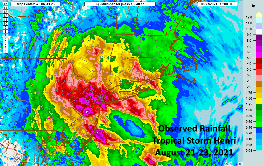
essexcountypete wrote:Anyone have data on reported storm totals for rainfall? The NWS color graphic is impressive, but I'm looking for reports. TIA!
.Selected preliminary Storm Total Rainfall in inches from 800 PM
EDT Sat Aug 21 through 1000 PM EDT Sun Aug 22...
...CONNECTICUT...
LEDYARD CENTER 4 SSE 3.70
NEW LONDON 3.70
NORWICH 3.25
GROTON 2.99
PAWCATUCK 2.39
...MASSACHUSETTS...
BECKET 2.25
PITTSFIELD 1.94
SANDISFIELD 3 S 1.72
EAST OTIS 1.67
...NEW JERSEY...
CRANBURY 8.91
JAMESBURG 8.36
PLAINSBORO TOWNSHIP 7.50
HOPEWELL 0.4 SSW 6.69
HARRISON 6.68
LONG BEACH TWP 1.4 SSE 6.49
HELMETTA 0.1 NE 6.17
JERSEY CITY 5.95
SURF CITY 5.81
SHIP BOTTOM 5.65
STRAFFORD TWP 2.2 NNE 5.25
MCGUIRE AFB 2.15
...NEW YORK...
BROOKLYN 8.03
PROSPECT PARK 7.77
SOUTH SLOPE 7.05
CENTRAL PARK 7.04
LAKE SUCCESS 1 WSW 6.58
MIDTOWN MANHATTAN 6.46
BOERUM HILL 6.16
BATTERY PARK 6.15
...PENNSYLVANIA...
ARDMORE 4.25
NEW HANOVER 2.06
EAGLEVILLE 1.93
BRISTOL 1.86
...RHODE ISLAND...
WESTERLY ARPT 2.73
SOUTH KINGSTOWN 2.48
COVENTRY 2.00
WESTERLY STATE AIRPORT 1.76
WAKEFIELD-PEACEDALE 5.0 SW 1.32
NEWPORT, NEWPORT STATE AIRPORT 1.21
SOUTH KINGSTON 4.3 WSW 1.00
CHARLESTOWN 0.7 E 0.98
WAKEFIELD 0.8 ENE 0.97
PROVIDENCE 0.38 THEODORE GREEN AIRPT
...Selected preliminary Peak Wind gusts in miles per hour earlier
in the event...
...CONNECTICUT...
STONGINGTON OUTER BREAKWATER 55
GROTON ARPT 53
USCG ACADEMY 49
STONINGTON OUTER BREAKWATER 48
HARTFORD BRADLEY INTL ARPT 44
...MASSACHUSETTS...
WOODS HOLE 55
MASHPEE 51
WEST ISLAND 51
WELLFLEET 48
BORDEN FLATS LIGHT 47
DUXBURY 47
VINEYARD STATION 46
WEST DENNIS 45
...NEW YORK...
GREAT GULL ISLAND 69
STONY BROOK 53
BAITING HOLLOW 52
ORIENT 1 N 50
SHINNECOCK 49
NAPEAGUE 48
...RHODE ISLAND...
POINT JUDITH 70
UNIVERSITY OF RHODE ISLAND 69
HALFWAY ROCK 68
BLOCK ISLAND JETTY 63
NEW SHOREHAM 63
For the latest rainfall forecast and Excessive Rainfall Outlooks
associated with Tropical Storm Henri, please refer to
www.wpc.noaa.gov
The next Storm Summary will be issued by the Weather Prediction
Center at 1100 AM EDT. Please refer to your local National Weather
Service office for additional information on this event.
Quigley
_________________
"In weather and in life, there's no winning and losing; there's only winning and learning."
WINTER 2012/2013 TOTALS 43.65"WINTER 2017/2018 TOTALS 62.85" WINTER 2022/2023 TOTALS 4.9"
WINTER 2013/2014 TOTALS 64.85"WINTER 2018/2019 TOTALS 14.25" WINTER 2023/2024 TOTALS 13.1"
WINTER 2014/2015 TOTALS 71.20"WINTER 2019/2020 TOTALS 6.35"
WINTER 2015/2016 TOTALS 35.00"WINTER 2020/2021 TOTALS 37.75"
WINTER 2016/2017 TOTALS 42.25"WINTER 2021/2022 TOTALS 31.65"
sroc4- Admin
- Posts : 8331
Reputation : 301
Join date : 2013-01-07
Location : Wading River, LI
Re: Tropical Storm HENRI: Discussions and Observations
![]() by sroc4 Mon Aug 23, 2021 10:29 am
by sroc4 Mon Aug 23, 2021 10:29 am
sroc4 wrote:essexcountypete wrote:Anyone have data on reported storm totals for rainfall? The NWS color graphic is impressive, but I'm looking for reports. TIA!
.Selected preliminary Storm Total Rainfall in inches from 800 PM
EDT Sat Aug 21 through 1000 PM EDT Sun Aug 22...
...CONNECTICUT...
LEDYARD CENTER 4 SSE 3.70
NEW LONDON 3.70
NORWICH 3.25
GROTON 2.99
PAWCATUCK 2.39
...MASSACHUSETTS...
BECKET 2.25
PITTSFIELD 1.94
SANDISFIELD 3 S 1.72
EAST OTIS 1.67
...NEW JERSEY...
CRANBURY 8.91
JAMESBURG 8.36
PLAINSBORO TOWNSHIP 7.50
HOPEWELL 0.4 SSW 6.69
HARRISON 6.68
LONG BEACH TWP 1.4 SSE 6.49
HELMETTA 0.1 NE 6.17
JERSEY CITY 5.95
SURF CITY 5.81
SHIP BOTTOM 5.65
STRAFFORD TWP 2.2 NNE 5.25
MCGUIRE AFB 2.15
...NEW YORK...
BROOKLYN 8.03
PROSPECT PARK 7.77
SOUTH SLOPE 7.05
CENTRAL PARK 7.04
LAKE SUCCESS 1 WSW 6.58
MIDTOWN MANHATTAN 6.46
BOERUM HILL 6.16
BATTERY PARK 6.15
...PENNSYLVANIA...
ARDMORE 4.25
NEW HANOVER 2.06
EAGLEVILLE 1.93
BRISTOL 1.86
...RHODE ISLAND...
WESTERLY ARPT 2.73
SOUTH KINGSTOWN 2.48
COVENTRY 2.00
WESTERLY STATE AIRPORT 1.76
WAKEFIELD-PEACEDALE 5.0 SW 1.32
NEWPORT, NEWPORT STATE AIRPORT 1.21
SOUTH KINGSTON 4.3 WSW 1.00
CHARLESTOWN 0.7 E 0.98
WAKEFIELD 0.8 ENE 0.97
PROVIDENCE 0.38 THEODORE GREEN AIRPT
...Selected preliminary Peak Wind gusts in miles per hour earlier
in the event...
...CONNECTICUT...
STONGINGTON OUTER BREAKWATER 55
GROTON ARPT 53
USCG ACADEMY 49
STONINGTON OUTER BREAKWATER 48
HARTFORD BRADLEY INTL ARPT 44
...MASSACHUSETTS...
WOODS HOLE 55
MASHPEE 51
WEST ISLAND 51
WELLFLEET 48
BORDEN FLATS LIGHT 47
DUXBURY 47
VINEYARD STATION 46
WEST DENNIS 45
...NEW YORK...
GREAT GULL ISLAND 69
STONY BROOK 53
BAITING HOLLOW 52
ORIENT 1 N 50
SHINNECOCK 49
NAPEAGUE 48
...RHODE ISLAND...
POINT JUDITH 70
UNIVERSITY OF RHODE ISLAND 69
HALFWAY ROCK 68
BLOCK ISLAND JETTY 63
NEW SHOREHAM 63
For the latest rainfall forecast and Excessive Rainfall Outlooks
associated with Tropical Storm Henri, please refer to
www.wpc.noaa.gov
The next Storm Summary will be issued by the Weather Prediction
Center at 1100 AM EDT. Please refer to your local National Weather
Service office for additional information on this event.
Quigley
Sorry this is old data. Ill keep searching
_________________
"In weather and in life, there's no winning and losing; there's only winning and learning."
WINTER 2012/2013 TOTALS 43.65"WINTER 2017/2018 TOTALS 62.85" WINTER 2022/2023 TOTALS 4.9"
WINTER 2013/2014 TOTALS 64.85"WINTER 2018/2019 TOTALS 14.25" WINTER 2023/2024 TOTALS 13.1"
WINTER 2014/2015 TOTALS 71.20"WINTER 2019/2020 TOTALS 6.35"
WINTER 2015/2016 TOTALS 35.00"WINTER 2020/2021 TOTALS 37.75"
WINTER 2016/2017 TOTALS 42.25"WINTER 2021/2022 TOTALS 31.65"
sroc4- Admin
- Posts : 8331
Reputation : 301
Join date : 2013-01-07
Location : Wading River, LI
Re: Tropical Storm HENRI: Discussions and Observations
![]() by essexcountypete Mon Aug 23, 2021 10:49 am
by essexcountypete Mon Aug 23, 2021 10:49 am
sroc4 wrote:sroc4 wrote:essexcountypete wrote:Anyone have data on reported storm totals for rainfall? The NWS color graphic is impressive, but I'm looking for reports. TIA!
.Selected preliminary Storm Total Rainfall in inches from 800 PM
EDT Sat Aug 21 through 1000 PM EDT Sun Aug 22...
...CONNECTICUT...
LEDYARD CENTER 4 SSE 3.70
NEW LONDON 3.70
NORWICH 3.25
GROTON 2.99
PAWCATUCK 2.39
...MASSACHUSETTS...
BECKET 2.25
PITTSFIELD 1.94
SANDISFIELD 3 S 1.72
EAST OTIS 1.67
...NEW JERSEY...
CRANBURY 8.91
JAMESBURG 8.36
PLAINSBORO TOWNSHIP 7.50
HOPEWELL 0.4 SSW 6.69
HARRISON 6.68
LONG BEACH TWP 1.4 SSE 6.49
HELMETTA 0.1 NE 6.17
JERSEY CITY 5.95
SURF CITY 5.81
SHIP BOTTOM 5.65
STRAFFORD TWP 2.2 NNE 5.25
MCGUIRE AFB 2.15
...NEW YORK...
BROOKLYN 8.03
PROSPECT PARK 7.77
SOUTH SLOPE 7.05
CENTRAL PARK 7.04
LAKE SUCCESS 1 WSW 6.58
MIDTOWN MANHATTAN 6.46
BOERUM HILL 6.16
BATTERY PARK 6.15
...PENNSYLVANIA...
ARDMORE 4.25
NEW HANOVER 2.06
EAGLEVILLE 1.93
BRISTOL 1.86
...RHODE ISLAND...
WESTERLY ARPT 2.73
SOUTH KINGSTOWN 2.48
COVENTRY 2.00
WESTERLY STATE AIRPORT 1.76
WAKEFIELD-PEACEDALE 5.0 SW 1.32
NEWPORT, NEWPORT STATE AIRPORT 1.21
SOUTH KINGSTON 4.3 WSW 1.00
CHARLESTOWN 0.7 E 0.98
WAKEFIELD 0.8 ENE 0.97
PROVIDENCE 0.38 THEODORE GREEN AIRPT
...Selected preliminary Peak Wind gusts in miles per hour earlier
in the event...
...CONNECTICUT...
STONGINGTON OUTER BREAKWATER 55
GROTON ARPT 53
USCG ACADEMY 49
STONINGTON OUTER BREAKWATER 48
HARTFORD BRADLEY INTL ARPT 44
...MASSACHUSETTS...
WOODS HOLE 55
MASHPEE 51
WEST ISLAND 51
WELLFLEET 48
BORDEN FLATS LIGHT 47
DUXBURY 47
VINEYARD STATION 46
WEST DENNIS 45
...NEW YORK...
GREAT GULL ISLAND 69
STONY BROOK 53
BAITING HOLLOW 52
ORIENT 1 N 50
SHINNECOCK 49
NAPEAGUE 48
...RHODE ISLAND...
POINT JUDITH 70
UNIVERSITY OF RHODE ISLAND 69
HALFWAY ROCK 68
BLOCK ISLAND JETTY 63
NEW SHOREHAM 63
For the latest rainfall forecast and Excessive Rainfall Outlooks
associated with Tropical Storm Henri, please refer to
www.wpc.noaa.gov
The next Storm Summary will be issued by the Weather Prediction
Center at 1100 AM EDT. Please refer to your local National Weather
Service office for additional information on this event.
Quigley
Sorry this is old data. Ill keep searching
No, this is great. This covers Saturday night up to 10pm last night, which captures almost the whole storm, for me at least. Thank you!!!
essexcountypete- Pro Enthusiast
- Posts : 783
Reputation : 12
Join date : 2013-12-09
Location : Bloomfield, NJ
sroc4 likes this post
Re: Tropical Storm HENRI: Discussions and Observations
![]() by amugs Mon Aug 23, 2021 11:23 am
by amugs Mon Aug 23, 2021 11:23 am
_________________
Mugs
AKA:King: Snow Weenie
Self Proclaimed
WINTER 2014-15 : 55.12" +.02 for 6 coatings (avg. 35")
WINTER 2015-16 Total - 29.8" (Avg 35")
WINTER 2016-17 : 39.5" so far
amugs- Advanced Forecaster - Mod
- Posts : 15093
Reputation : 213
Join date : 2013-01-07
Age : 54
Location : Hillsdale,NJ
Re: Tropical Storm HENRI: Discussions and Observations
![]() by Zhukov1945 Mon Aug 23, 2021 11:38 am
by Zhukov1945 Mon Aug 23, 2021 11:38 am
amugs wrote:
So do NAM and HRRR get the gold with this one (to the extent any model deserves it)? Yes, they were late to latch on to the more easterly track solution, but they absolutely got it right on the left hook and the NJ rain in a way none of the other models iirc got at all...

Zhukov1945- Posts : 138
Reputation : 8
Join date : 2018-03-21
Location : Clinton Township NJ
essexcountypete likes this post
Re: Tropical Storm HENRI: Discussions and Observations
![]() by rb924119 Mon Aug 23, 2021 1:19 pm
by rb924119 Mon Aug 23, 2021 1:19 pm
1. Your kind words and support for all of us involved in the forecasting process. I’ll expand on this later.
2. Everybody who got involved in the discussion, whether providing analysis, posting updates/observations, and or asking questions. The combination of all of those actions really helped to foster a really great discussion and environment so people could debate, learn, and last but certainly not least, get prepared. The number one mission of a meteorologist is to save life and property, and I think that even though nobody got the track completely correct, I think our ideas and level of alert allowed sufficient time and evidence to prepare for at least a close call. Mission accomplished there.
3. For those of you who quietly followed along, or only sporadically posted, thank you for following us through the entire evolution of this storm. As a forecaster, and maybe the only person crazy enough to go out on the limb as far as I was that this storm was on, I have to admit I was very nervous of raising a false alarm. That’s the one thing, again, as a forecaster, I DON’T want to do. And when I made the first mention of this two Tuesdays ago, and then again last Monday, when I had zero support from anything, I can only imagine what you all were thinking of my ideas at those points lol so thank you for giving me and my ideas a chance, and thank you for following and being a part of the entire process. Your trust, your support, and your enthusiasm are things that I don’t take for granted, and I’m sure I can say the same for all of the other forecasters on this forum. And we do our best to give you the best information we can.
rb924119- Meteorologist

- Posts : 6890
Reputation : 194
Join date : 2013-02-06
Age : 32
Location : Greentown, Pa
brownie and phil155 like this post
Re: Tropical Storm HENRI: Discussions and Observations
![]() by Zhukov1945 Mon Aug 23, 2021 1:23 pm
by Zhukov1945 Mon Aug 23, 2021 1:23 pm
rb924119 wrote:I’ll have some closing thoughts coming over the next day or two, but I would just like to say thank you to everybody for a few things:
1. Your kind words and support for all of us involved in the forecasting process. I’ll expand on this later.
2. Everybody who got involved in the discussion, whether providing analysis, posting updates/observations, and or asking questions. The combination of all of those actions really helped to foster a really great discussion and environment so people could debate, learn, and last but certainly not least, get prepared. The number one mission of a meteorologist is to save life and property, and I think that even though nobody got the track completely correct, I think our ideas and level of alert allowed sufficient time and evidence to prepare for at least a close call. Mission accomplished there.
3. For those of you who quietly followed along, or only sporadically posted, thank you for following us through the entire evolution of this storm. As a forecaster, and maybe the only person crazy enough to go out on the limb as far as I was that this storm was on, I have to admit I was very nervous of raising a false alarm. That’s the one thing, again, as a forecaster, I DON’T want to do. And when I made the first mention of this two Tuesdays ago, and then again last Monday, when I had zero support from anything, I can only imagine what you all were thinking of my ideas at those points lol so thank you for giving me and my ideas a chance, and thank you for following and being a part of the entire process. Your trust, your support, and your enthusiasm are things that I don’t take for granted, and I’m sure I can say the same for all of the other forecasters on this forum. And we do our best to give you the best information we can.
You got the big picture very, very right when almost no one else was even talking about it, and you got the specifics pretty right even if it ended up being north and east of where you thought...so thank you, it was a very fun ride.
Zhukov1945- Posts : 138
Reputation : 8
Join date : 2018-03-21
Location : Clinton Township NJ
phil155 likes this post
Re: Tropical Storm HENRI: Discussions and Observations
![]() by Dunnzoo Mon Aug 23, 2021 4:52 pm
by Dunnzoo Mon Aug 23, 2021 4:52 pm
Unbelievable!
_________________
Janet
Snowfall winter of 2023-2024 17.5"
Snowfall winter of 2022-2023 6.0"
Snowfall winter of 2021-2022 17.6" 1" sleet 2/25/22
Snowfall winter of 2020-2021 51.1"
Snowfall winter of 2019-2020 8.5"
Snowfall winter of 2018-2019 25.1"
Snowfall winter of 2017-2018 51.9"
Snowfall winter of 2016-2017 45.6"
Snowfall winter of 2015-2016 29.5"
Snowfall winter of 2014-2015 50.55"
Snowfall winter of 2013-2014 66.5"

Dunnzoo- Senior Enthusiast - Mod
- Posts : 4891
Reputation : 68
Join date : 2013-01-11
Age : 62
Location : Westwood, NJ
sroc4 and weatherwatchermom like this post
Page 3 of 3 • 1, 2, 3
|
|
|