Tropical Storm HENRI: Discussions and Observations
+10
Zhukov1945
brownie
Grselig
essexcountypete
hyde345
amugs
frank 638
Joe Snow
jmanley32
sroc4
14 posters
Page 1 of 3 • 1, 2, 3 
 Tropical Storm HENRI: Discussions and Observations
Good morning everyone. Lets continue any and all discussions and observations about Henri here. Im sure there are many out there in my shoes right now.
Conflicted
The sensible, mature, home and business owning, with two kids to worry about adult is thrilled that the worst case with this one is not going to be realized. That said, while I did prepare for the worst, and was ready to experience the thrill of it should it have transpired, the weather geek part of me is definitely disappointed.
There is no doubt the thrill of the tracking is always a huge part of the excitement and leads to the anticipation of the outcome. So when that anticipation for a major event has been building there is always that feeling of let down when it isn't quite what was anticipated; again still extremely thankful at the same time as my house is surrounded by 75-100ft oak trees.
I know Rb is perplexed by the outcome, but I stand by my prev ideas. When Henri was still on its W/WSW trajectory early on the wind shear def played an important role. The shear tilted his circulation where the mid level center remained well south of the low level center. This led to the models who had him intensifying more rapidly to struggle with the soln along the way.
The second part of the equation came once he started turning northward. This is where Rb and I's debate comes into play.
The Upper Level Low ULL cutting off from the mean flow centering over the spine of the Appalachians was the first key element for Henri to turn N, but would there be a true injection of energy? Would there be a tilt negative that would draw him in way to the west etc.?
Lets take a quick look at this image here below. This was the 500mb wind map valid 2am 8/21. This was about the time we began to see him turn north. Here are your two features labeled. The long wave trough (LWT) and and upper level low (ULL). By definition they are both troughs yes, but they are def not the same.
Look at the ULL first. It is cut off from the mean flow. Put another way it is independent from the jetstream that flows west to east across the continent. The result of this cut off from the mean flow is its just kind of bobbing; not moving, as it hangs south of the mean flow. Because it is cut off from the mean flow its wind fields are rotating in a circular fashion but overall remain relatively constant around the circular flow. The outermost height fields on the north side are the same as the south side because its a cutt off low.(circular wind flow around it) The result is fairly uniform, light winds that rotate around its center. The other thing to note is that there is no defined base to the ULL because it's a circle. This will be important later. You can see there are only small non focused areas of light blue colors within the area I have defined as the ULL. These colors indicate wind speed.
Now take a look at the LWT. Notice there is a true defined base to a LWT. Notice the colors within the base of the LWT. Notice it is much more focused and large area of greens and yellows and even some oranges, indicated much faster wind speeds. This is the equivalent of a Ferrari coming off a straight away and accelerating into a hair pin turn, vs a Toyta Corrola going round and round a much more gentle rounded track at a more constant slower speed with only subtle changes in speed around the track. The point is this. If your a car that merges into both scenarios and hits into the Ferarri there is going to be a much more explosive crash merging into the Ferarri at a steeper angle that is actively accelerating and is at 60mph, vs one that merges into oncoming traffic more gently where the Toyota Corolla is only moving at 15-20 mph and the angle at which it enters the flow is much more gentle. This point, if it even makes sense, is why I believe Henri simply calmly merged into traffic with the cutoff low. There was no explosive accident at all, but rather a gentle side by side brush by that showed Herni which direction traffic was flowing.
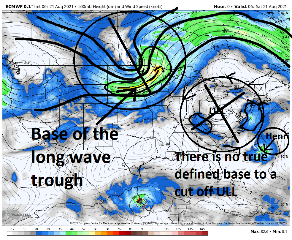
Now lets shift gears a touch here and say ok Henri has merged into traffic and began to head north being guided by the Toyota corolla. The track the Toyota is on stil truns to the NW eventually. The track in the static image has it such that in theory it should have turned Henri much further west. So why did he slip east? Well Ive been harping on this for some time now but timing is everything.
Ive stated that after the ULL captures Henri within its height fields, the LWT eventually captures the ULL on the NW flank. As LWT do they are not static. Unlike the ULL which was cut off from that west to east flow a LWT is always on the move. Once it interacts with the ULL, the ULL finally begins to get on the move. It no longer is cut off from the mean flow but becomes a part of it. Since the ULL has already began interacting with Henri, as it begins to feel the effects from the flow of the LWT the entire complex begins to move west to east with the Mean flow. See the images below. The timing of the LWT eroded the NW flank of the ridge just quick enough such that the mean flow from west to east nudged him east.
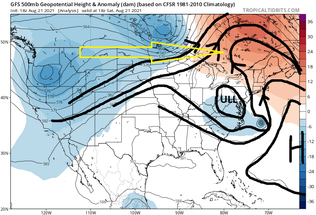
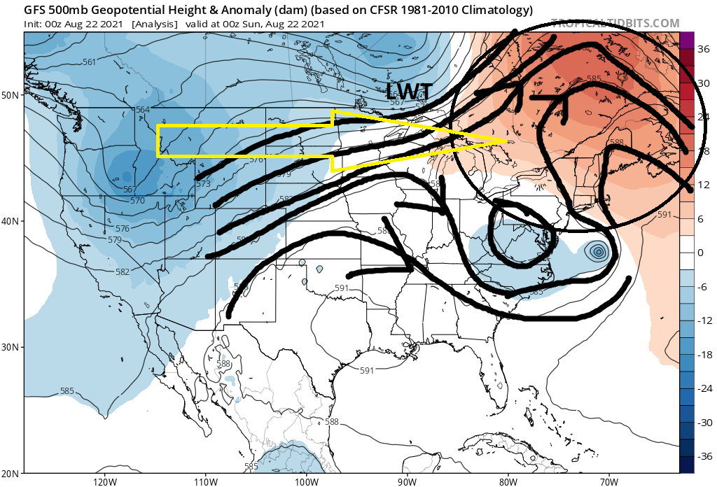

Now here is the thing. If the LWT was a mere 6-12 hrs later in its timing the track would have most certainly been further west as Henri would have been pivoted around the axis point between it and the ULL.
The final point to make here is what happened to the intensity forecast? With the exception of the Euro, which had its struggles along the way, but overall was onto the idea that Henri would ultimately end up much weaker than most other modeling was indicating. (All hail King Euro). Why. Well going back to the shear discussion. The shear absolutely disrupted Herni's ability to strengthen. It caused his rotation to tilt. His mid level center was always south relative to his low level center. He never was able to vertically stack until it was too late. Even after the shear had died down he was so disorgaized at the various levels of the atmosphere it was very diff for him to reorganize.
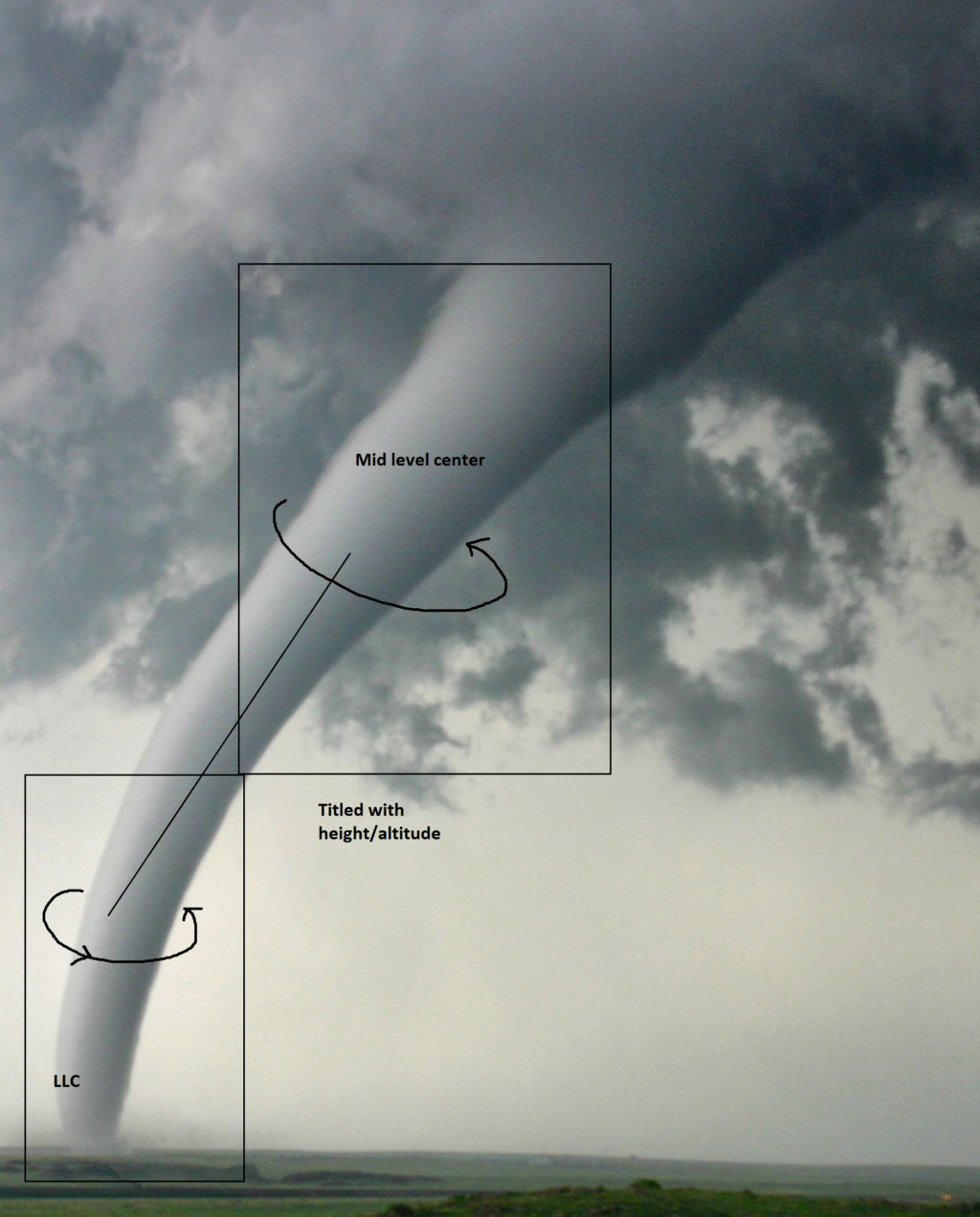
I think in addition to the timing of the LWT, and perhaps independent of the LWT, if he had been able to get his act together sooner it would have led to a track further west. I also think that, because of reasoning above, there was no real injection of energy from the ULL, but rather I think the timing and positioning of the ULL was such that it likely was a major contributor as to why Henri was having trouble organizing. I think the ULL was actually "stealing" energy from Henri. While you guys were watching the convection being pulled west away from Henri thinking it was Henri actually turning due west, it was actually the weak energy embedded within and circulation around the ULL that was creating disruption in the atmosphere to Henri's entire western side such that he had trouble vertically stacking and revving up his engine. That Im not entirely sure about, but looking at observations between late afternoon and last night it sure seemed that way.
Anyway it was still a really fun one to track. There wasn't a single one of us that got this system pegged. Heck my original thoughts took Henri about 75-100miles east of Cape cod. But without a doubt collectively we had this system covered pretty damn well with Ray leading the way going back almost two full weeks with this statement back on August 10th:
by rb924119 Tue Aug 10, 2021 11:13 pm
I don’t like what I’m seeing in the Day 8-12 period. Newfoundland Wheel gonna be spinning in place in a blocked North Atlantic pattern. I’m not *necessarily* concerned with something coming out of the deep tropics per se’, although that is also a formidable risk with MJO Phase 2/3, especially with the advertised blocking. But I’d definitely be on the lookout for a tropical transition of a disturbance that can sit and fester beneath the block and then be driven westward beneath it while strengthens coming ashore. Especially since there’s a well advertised, potential cold front pushing through thanks to the West-Pac typhoons earlier last week. This requires a deeper dive over the next couple of days for sure, because it’s got my attention.
Stay safe every one.
We track!!!
Conflicted
The sensible, mature, home and business owning, with two kids to worry about adult is thrilled that the worst case with this one is not going to be realized. That said, while I did prepare for the worst, and was ready to experience the thrill of it should it have transpired, the weather geek part of me is definitely disappointed.
There is no doubt the thrill of the tracking is always a huge part of the excitement and leads to the anticipation of the outcome. So when that anticipation for a major event has been building there is always that feeling of let down when it isn't quite what was anticipated; again still extremely thankful at the same time as my house is surrounded by 75-100ft oak trees.
I know Rb is perplexed by the outcome, but I stand by my prev ideas. When Henri was still on its W/WSW trajectory early on the wind shear def played an important role. The shear tilted his circulation where the mid level center remained well south of the low level center. This led to the models who had him intensifying more rapidly to struggle with the soln along the way.
The second part of the equation came once he started turning northward. This is where Rb and I's debate comes into play.
The Upper Level Low ULL cutting off from the mean flow centering over the spine of the Appalachians was the first key element for Henri to turn N, but would there be a true injection of energy? Would there be a tilt negative that would draw him in way to the west etc.?
Lets take a quick look at this image here below. This was the 500mb wind map valid 2am 8/21. This was about the time we began to see him turn north. Here are your two features labeled. The long wave trough (LWT) and and upper level low (ULL). By definition they are both troughs yes, but they are def not the same.
Look at the ULL first. It is cut off from the mean flow. Put another way it is independent from the jetstream that flows west to east across the continent. The result of this cut off from the mean flow is its just kind of bobbing; not moving, as it hangs south of the mean flow. Because it is cut off from the mean flow its wind fields are rotating in a circular fashion but overall remain relatively constant around the circular flow. The outermost height fields on the north side are the same as the south side because its a cutt off low.(circular wind flow around it) The result is fairly uniform, light winds that rotate around its center. The other thing to note is that there is no defined base to the ULL because it's a circle. This will be important later. You can see there are only small non focused areas of light blue colors within the area I have defined as the ULL. These colors indicate wind speed.
Now take a look at the LWT. Notice there is a true defined base to a LWT. Notice the colors within the base of the LWT. Notice it is much more focused and large area of greens and yellows and even some oranges, indicated much faster wind speeds. This is the equivalent of a Ferrari coming off a straight away and accelerating into a hair pin turn, vs a Toyta Corrola going round and round a much more gentle rounded track at a more constant slower speed with only subtle changes in speed around the track. The point is this. If your a car that merges into both scenarios and hits into the Ferarri there is going to be a much more explosive crash merging into the Ferarri at a steeper angle that is actively accelerating and is at 60mph, vs one that merges into oncoming traffic more gently where the Toyota Corolla is only moving at 15-20 mph and the angle at which it enters the flow is much more gentle. This point, if it even makes sense, is why I believe Henri simply calmly merged into traffic with the cutoff low. There was no explosive accident at all, but rather a gentle side by side brush by that showed Herni which direction traffic was flowing.

Now lets shift gears a touch here and say ok Henri has merged into traffic and began to head north being guided by the Toyota corolla. The track the Toyota is on stil truns to the NW eventually. The track in the static image has it such that in theory it should have turned Henri much further west. So why did he slip east? Well Ive been harping on this for some time now but timing is everything.
Ive stated that after the ULL captures Henri within its height fields, the LWT eventually captures the ULL on the NW flank. As LWT do they are not static. Unlike the ULL which was cut off from that west to east flow a LWT is always on the move. Once it interacts with the ULL, the ULL finally begins to get on the move. It no longer is cut off from the mean flow but becomes a part of it. Since the ULL has already began interacting with Henri, as it begins to feel the effects from the flow of the LWT the entire complex begins to move west to east with the Mean flow. See the images below. The timing of the LWT eroded the NW flank of the ridge just quick enough such that the mean flow from west to east nudged him east.


Now here is the thing. If the LWT was a mere 6-12 hrs later in its timing the track would have most certainly been further west as Henri would have been pivoted around the axis point between it and the ULL.
The final point to make here is what happened to the intensity forecast? With the exception of the Euro, which had its struggles along the way, but overall was onto the idea that Henri would ultimately end up much weaker than most other modeling was indicating. (All hail King Euro). Why. Well going back to the shear discussion. The shear absolutely disrupted Herni's ability to strengthen. It caused his rotation to tilt. His mid level center was always south relative to his low level center. He never was able to vertically stack until it was too late. Even after the shear had died down he was so disorgaized at the various levels of the atmosphere it was very diff for him to reorganize.

I think in addition to the timing of the LWT, and perhaps independent of the LWT, if he had been able to get his act together sooner it would have led to a track further west. I also think that, because of reasoning above, there was no real injection of energy from the ULL, but rather I think the timing and positioning of the ULL was such that it likely was a major contributor as to why Henri was having trouble organizing. I think the ULL was actually "stealing" energy from Henri. While you guys were watching the convection being pulled west away from Henri thinking it was Henri actually turning due west, it was actually the weak energy embedded within and circulation around the ULL that was creating disruption in the atmosphere to Henri's entire western side such that he had trouble vertically stacking and revving up his engine. That Im not entirely sure about, but looking at observations between late afternoon and last night it sure seemed that way.
Anyway it was still a really fun one to track. There wasn't a single one of us that got this system pegged. Heck my original thoughts took Henri about 75-100miles east of Cape cod. But without a doubt collectively we had this system covered pretty damn well with Ray leading the way going back almost two full weeks with this statement back on August 10th:
by rb924119 Tue Aug 10, 2021 11:13 pm
I don’t like what I’m seeing in the Day 8-12 period. Newfoundland Wheel gonna be spinning in place in a blocked North Atlantic pattern. I’m not *necessarily* concerned with something coming out of the deep tropics per se’, although that is also a formidable risk with MJO Phase 2/3, especially with the advertised blocking. But I’d definitely be on the lookout for a tropical transition of a disturbance that can sit and fester beneath the block and then be driven westward beneath it while strengthens coming ashore. Especially since there’s a well advertised, potential cold front pushing through thanks to the West-Pac typhoons earlier last week. This requires a deeper dive over the next couple of days for sure, because it’s got my attention.
Stay safe every one.
We track!!!

_________________
"In weather and in life, there's no winning and losing; there's only winning and learning."
WINTER 2012/2013 TOTALS 43.65"WINTER 2017/2018 TOTALS 62.85" WINTER 2022/2023 TOTALS 4.9"
WINTER 2013/2014 TOTALS 64.85"WINTER 2018/2019 TOTALS 14.25" WINTER 2023/2024 TOTALS 13.1"
WINTER 2014/2015 TOTALS 71.20"WINTER 2019/2020 TOTALS 6.35"
WINTER 2015/2016 TOTALS 35.00"WINTER 2020/2021 TOTALS 37.75"
WINTER 2016/2017 TOTALS 42.25"WINTER 2021/2022 TOTALS 31.65"

sroc4- Admin

- Posts : 8354
Reputation : 302
Join date : 2013-01-07
Location : Wading River, LI
 Re: Tropical Storm HENRI: Discussions and Observations
Hey scott, great job with this one but great job to rb and apparently me haha. Just raining now, the rain does not even look like it is directly related to Henri. Ironic part, it was looking like Henri was go hit central CT, well central CT is actually in a complete dry slot no rain no wind, right over my parents house so I am very glad for them. Yes i am mbummed in the same way you are but having no power would have sucked and honestly I was just so tired early AM I was really annoyed to see it did not transpire but you gotta realize we have to just move on. I am going to try to implement the same thinking about winter storms so I do not get upset if I get a miss. Lots to be learned on this one. Now to things I have neglected all week lmao

jmanley32- Senior Enthusiast

- Posts : 20535
Reputation : 108
Join date : 2013-12-12
Age : 43
Location : Yonkers, NY
 Re: Tropical Storm HENRI: Discussions and Observations
The wind definitely pick up here in Kings Park. Gettig squalls of rain as well.

Joe Snow- Pro Enthusiast

- Posts : 924
Reputation : 7
Join date : 2014-02-12
Age : 62
Location : Sanford Florida, Fmrly Kings Park, NY
 Re: Tropical Storm HENRI: Discussions and Observations
_________________
"In weather and in life, there's no winning and losing; there's only winning and learning."
WINTER 2012/2013 TOTALS 43.65"WINTER 2017/2018 TOTALS 62.85" WINTER 2022/2023 TOTALS 4.9"
WINTER 2013/2014 TOTALS 64.85"WINTER 2018/2019 TOTALS 14.25" WINTER 2023/2024 TOTALS 13.1"
WINTER 2014/2015 TOTALS 71.20"WINTER 2019/2020 TOTALS 6.35"
WINTER 2015/2016 TOTALS 35.00"WINTER 2020/2021 TOTALS 37.75"
WINTER 2016/2017 TOTALS 42.25"WINTER 2021/2022 TOTALS 31.65"

sroc4- Admin

- Posts : 8354
Reputation : 302
Join date : 2013-01-07
Location : Wading River, LI
 Re: Tropical Storm HENRI: Discussions and Observations
A steady rain and still calm winds . Thank you so much to jman
Scott and everyone for all ur hard work I know when it comes to hurricane tropical storms or any other storms it is hard to predict . I know we have different weather models and some of them can be wrong but you guys really did a great job for the storm .Another thing to that drives me crazy is I told my coworkers and friends and family to be prepared just in case And what do I get it all yelling and screaming at me for buying a generator for nothing open flashlight or batteries And I tell them why the hell will you wait till last minute to stock up .I always tell them if you live in an area that loses power by a Generator just be prepared that’s all I tell them because when it comes to weather we don’t know what’s gonna happen next stay safe everyone
Scott and everyone for all ur hard work I know when it comes to hurricane tropical storms or any other storms it is hard to predict . I know we have different weather models and some of them can be wrong but you guys really did a great job for the storm .Another thing to that drives me crazy is I told my coworkers and friends and family to be prepared just in case And what do I get it all yelling and screaming at me for buying a generator for nothing open flashlight or batteries And I tell them why the hell will you wait till last minute to stock up .I always tell them if you live in an area that loses power by a Generator just be prepared that’s all I tell them because when it comes to weather we don’t know what’s gonna happen next stay safe everyone
frank 638- Senior Enthusiast

- Posts : 2843
Reputation : 37
Join date : 2016-01-01
Age : 40
Location : bronx ny
 Re: Tropical Storm HENRI: Discussions and Observations
[quote="frank 638"]A steady rain and still calm winds . Thank you so much to jman
Scott and everyone for all ur hard work I know when it comes to hurricane tropical storms or any other storms it is hard to predict . I know we have different weather models and some of them can be wrong but you guys really did a great job for the storm .Another thing to that drives me crazy is I told my coworkers and friends and family to be prepared just in case And instead saying thank you they tell me They spent money for nothing for generators stocking up and so on.
My response was why the hell do you always wait for the last minute especially where they live they always lose power for days.
For now on I am not saying anything about a upcoming storm lol Let them figure it out
frank 638- Senior Enthusiast

- Posts : 2843
Reputation : 37
Join date : 2016-01-01
Age : 40
Location : bronx ny
 Re: Tropical Storm HENRI: Discussions and Observations

Steady rains with heavy periods
_________________
Mugs
AKA:King: Snow Weenie
Self Proclaimed
WINTER 2014-15 : 55.12" +.02 for 6 coatings (avg. 35")
WINTER 2015-16 Total - 29.8" (Avg 35")
WINTER 2016-17 : 39.5" so far

amugs- Advanced Forecaster - Mod

- Posts : 15095
Reputation : 213
Join date : 2013-01-07
Age : 54
Location : Hillsdale,NJ
 Re: Tropical Storm HENRI: Discussions and Observations
Hearing stonington CT is go be landfall

jmanley32- Senior Enthusiast

- Posts : 20535
Reputation : 108
Join date : 2013-12-12
Age : 43
Location : Yonkers, NY
 Re: Tropical Storm HENRI: Discussions and Observations
and the western side Henri hasn't even hit that's insane.amugs wrote:
Steady rains with heavy periods

jmanley32- Senior Enthusiast

- Posts : 20535
Reputation : 108
Join date : 2013-12-12
Age : 43
Location : Yonkers, NY
 Re: Tropical Storm HENRI: Discussions and Observations
Official landfall was near Westerly RI, rb we were way off but NHC had it last night. Was still exciting thinking it turned west lol.
WOW incoming from the north to south, i could easily see some places seeing 15-20 inches of rain by the end, apparently NHC just said he will stall giving us persistent training rains all night and the flood watch is extended through tomorrow night. Not good, getting a bit breezy here but wind reports even near the center are not at all impressive.
http://sirocco.accuweather.com/nxssa_r1_h_500x620d/r1h/inxr1Knyca_h.gif

jmanley32- Senior Enthusiast

- Posts : 20535
Reputation : 108
Join date : 2013-12-12
Age : 43
Location : Yonkers, NY
 Re: Tropical Storm HENRI: Discussions and Observations
jmanley32 wrote:Official landfall was near Westerly RI, rb we were way off but NHC had it last night. Was still exciting thinking it turned west lol.
WOW incoming from the north to south, i could easily see some places seeing 15-20 inches of rain by the end, apparently NHC just said he will stall giving us persistent training rains all night and the flood watch is extended through tomorrow night. Not good, getting a bit breezy here but wind reports even near the center are not at all impressive.
http://sirocco.accuweather.com/nxssa_r1_h_500x620d/r1h/inxr1Knyca_h.gif
I really thought it was moving NW last night but the infrared satellite played tricks on my eyes I guess. Looking at radar it was moving in a 350-355 direction. Oh well. As far as rain is concerned it started raining here around noon and has been moderate to occasionally heavy. Lots more to come up here.

hyde345- Pro Enthusiast

- Posts : 1082
Reputation : 48
Join date : 2013-01-08
Location : Hyde Park, NY
 Re: Tropical Storm HENRI: Discussions and Observations
The good news we have no wind in my area the bad news we have lots of rain just got a alert on my phone 10 mins ago for a flash flood warning until 5 50 pm .
Jman how is it by u
Jman how is it by u
frank 638- Senior Enthusiast

- Posts : 2843
Reputation : 37
Join date : 2016-01-01
Age : 40
Location : bronx ny
 Re: Tropical Storm HENRI: Discussions and Observations
yeah we under warning too but for some reason i did not get the alert. its pouring getting a bit breezy rain now blowing in my window didnt realize sill and floor all wet, the wind was dead calm earlier. you can tell he is a bit closer.frank 638 wrote:The good news we have no wind in my area the bad news we have lots of rain just got a alert on my phone 10 mins ago for a flash flood warning until 5 50 pm .
Jman how is it by u

jmanley32- Senior Enthusiast

- Posts : 20535
Reputation : 108
Join date : 2013-12-12
Age : 43
Location : Yonkers, NY
 Re: Tropical Storm HENRI: Discussions and Observations

_________________
Mugs
AKA:King: Snow Weenie
Self Proclaimed
WINTER 2014-15 : 55.12" +.02 for 6 coatings (avg. 35")
WINTER 2015-16 Total - 29.8" (Avg 35")
WINTER 2016-17 : 39.5" so far

amugs- Advanced Forecaster - Mod

- Posts : 15095
Reputation : 213
Join date : 2013-01-07
Age : 54
Location : Hillsdale,NJ
 Re: Tropical Storm HENRI: Discussions and Observations
Moderate rain after a longer period of heavy rains.
Winds picking up.
Winds picking up.
_________________
Mugs
AKA:King: Snow Weenie
Self Proclaimed
WINTER 2014-15 : 55.12" +.02 for 6 coatings (avg. 35")
WINTER 2015-16 Total - 29.8" (Avg 35")
WINTER 2016-17 : 39.5" so far

amugs- Advanced Forecaster - Mod

- Posts : 15095
Reputation : 213
Join date : 2013-01-07
Age : 54
Location : Hillsdale,NJ
 Re: Tropical Storm HENRI: Discussions and Observations
I just heard on the news Brooklyn has received 8 inches of rain so far
frank 638- Senior Enthusiast

- Posts : 2843
Reputation : 37
Join date : 2016-01-01
Age : 40
Location : bronx ny
 Re: Tropical Storm HENRI: Discussions and Observations
not surprised I think we must had at least 4 or so. And it's supposed rain nonstop through tomorrow eadily 15 inches some places. Wpc needs up rainfrank 638 wrote:I just heard on the news Brooklyn has received 8 inches of rain so far

jmanley32- Senior Enthusiast

- Posts : 20535
Reputation : 108
Join date : 2013-12-12
Age : 43
Location : Yonkers, NY
 Re: Tropical Storm HENRI: Discussions and Observations
I noticed that Henri looks to be on the western side of the cone so we may get into the TS winds prolly low end but rain is going sideways now. This is still kinda thrilling a tiny bit lol

jmanley32- Senior Enthusiast

- Posts : 20535
Reputation : 108
Join date : 2013-12-12
Age : 43
Location : Yonkers, NY
 Re: Tropical Storm HENRI: Discussions and Observations
Wow Jesus rain is insane!!! Wind is really picking up too

jmanley32- Senior Enthusiast

- Posts : 20535
Reputation : 108
Join date : 2013-12-12
Age : 43
Location : Yonkers, NY
 Re: Tropical Storm HENRI: Discussions and Observations
Posted just now
Getting absolutely smoked here in NE NJ Hillsdale for the past 1.25 hrs. Literally 1.68" in the past hr maybe more since my rain gauge has been wonky.
Getting absolutely smoked here in NE NJ Hillsdale for the past 1.25 hrs. Literally 1.68" in the past hr maybe more since my rain gauge has been wonky.
_________________
Mugs
AKA:King: Snow Weenie
Self Proclaimed
WINTER 2014-15 : 55.12" +.02 for 6 coatings (avg. 35")
WINTER 2015-16 Total - 29.8" (Avg 35")
WINTER 2016-17 : 39.5" so far

amugs- Advanced Forecaster - Mod

- Posts : 15095
Reputation : 213
Join date : 2013-01-07
Age : 54
Location : Hillsdale,NJ
 Re: Tropical Storm HENRI: Discussions and Observations
Just got my fifth flood warning up the storm.
I'm guessing we've gotten four or five inches of rain. There's two to three inches of water in my backyard
I'm guessing we've gotten four or five inches of rain. There's two to three inches of water in my backyard

essexcountypete- Pro Enthusiast

- Posts : 783
Reputation : 12
Join date : 2013-12-09
Location : Bloomfield, NJ
 Re: Tropical Storm HENRI: Discussions and Observations
Holhy cow a 4 hr flash flood warning, a sinkhole opened up on westchester ave in mamaroneck, this rain is more serious than the winds that happened.

jmanley32- Senior Enthusiast

- Posts : 20535
Reputation : 108
Join date : 2013-12-12
Age : 43
Location : Yonkers, NY
 Re: Tropical Storm HENRI: Discussions and Observations
24 freaking hours more of rain!!! watching news, saying do not go out through tomorrow. 500 power outages in area, when we get a good convective band the winds really kick up.

jmanley32- Senior Enthusiast

- Posts : 20535
Reputation : 108
Join date : 2013-12-12
Age : 43
Location : Yonkers, NY
 Re: Tropical Storm HENRI: Discussions and Observations
I just realized all that rain to our west is going to pull back over the area once Henri heads east MADONNE!! tomorrow morning commute go be a nightmare.

jmanley32- Senior Enthusiast

- Posts : 20535
Reputation : 108
Join date : 2013-12-12
Age : 43
Location : Yonkers, NY
 Re: Tropical Storm HENRI: Discussions and Observations
Wow moving WNW 7mph, NOT GOOD, Epic flooding, possibly record breaking. no likely.

jmanley32- Senior Enthusiast

- Posts : 20535
Reputation : 108
Join date : 2013-12-12
Age : 43
Location : Yonkers, NY
Page 1 of 3 • 1, 2, 3 
Permissions in this forum:
You cannot reply to topics in this forum|
|
|

 Home
Home