January 22nd-23rd Storm
+9
amugs
docstox12
CPcantmeasuresnow
SENJsnowman
bobjohnsonforthehall
heehaw453
mikeypizano
jmanley32
Frank_Wx
13 posters
Page 1 of 2 • 1, 2 
 January 22nd-23rd Storm
The long range thread reached its max, so decided to start a separate thread for this weekends potential storm. Like Scott said, there’s a chance the GFS misses the phase that the EURO has but focuses on another piece of energy on the backside which could deliver snow here on Sunday.
There’s just SO much upper energy for these models to focus on that I’m not sure we’ll have resolution until tomorrow night or Thursday.
Continue discussions here. Big Euro run coming up!
There’s just SO much upper energy for these models to focus on that I’m not sure we’ll have resolution until tomorrow night or Thursday.
Continue discussions here. Big Euro run coming up!
_________________
_______________________________________________________________________________________________________
CLICK HERE to view NJ Strong Snowstorm Classifications
 Re: January 22nd-23rd Storm
Which way are you leaning right mow with what model info we have and what your expertise tells you, didn't you say last night if the GFS trended towards GFS and Euro held serve which I believe they both did that the chances of a major storm would go up a lot? Are you still thinking this I see you have it at 25% that was yesterday do you plan to increase it? After typing this I think it is obvious you do because you made a thread HAHA But now your saying its possible this is a sunday storm potentially?

jmanley32- Senior Enthusiast

- Posts : 20535
Reputation : 108
Join date : 2013-12-12
Age : 43
Location : Yonkers, NY
 Re: January 22nd-23rd Storm
jmanley32 wrote:Which way are you leaning right mow with what model info we have and what your expertise tells you, didn't you say last night if the GFS trended towards GFS and Euro held serve which I believe they both did that the chances of a major storm would go up a lot? Are you still thinking this I see you have it at 25% that was yesterday do you plan to increase it? After typing this I think it is obvious you do because you made a thread HAHA But now your saying its possible this is a sunday storm potentially?
So mugs posted in the last thread about how there’s multiple pieces of upper energy. This creates confusion between models because they’re all navigating these waves differently. The GFS tries to pop a low off the coast on Sunday while keeping the “Euro” storm to our south and mostly out to sea.
Personally, I think the EURO is overplaying its hand here. I’ve commented in the long range thread how I felt the main time period to concentrate on is 25th-1st as that’s when we gain back the EPO, PNA and MAYBE even the NAO.
However, when the EURO shows consecutive runs of moderate to heavy snow you can’t discount it. I just think the pattern turned too progressive and the GFS normally handles northern stream types better. The GEFS did tick west and now show sizable snow for coastal and southern NJ. If anything, I think Mid Atlantic into SNJ are in the cross hairs this weekend. Everyone else is at a lower risk, but let’s see what EURO shows in the next 30 minutes.
_________________
_______________________________________________________________________________________________________
CLICK HERE to view NJ Strong Snowstorm Classifications
jmanley32 likes this post
 Re: January 22nd-23rd Storm
From the early looks of it I think the EURO trended worse at 500mb, but I think it’s still going to show the storm on Saturday. MAYBE weaker and more S&E. Let’s see
_________________
_______________________________________________________________________________________________________
CLICK HERE to view NJ Strong Snowstorm Classifications
 Re: January 22nd-23rd Storm
Honestly, this all kinda looks strung out and messy. Definitely seems as if the EURO is holding back more energy than prior runs. So far, this run is a nod toward the GFS


_________________
_______________________________________________________________________________________________________
CLICK HERE to view NJ Strong Snowstorm Classifications
 Re: January 22nd-23rd Storm
I hope this works out better than the slopfest I got rom this last one...

mikeypizano- Pro Enthusiast

- Posts : 1118
Reputation : 66
Join date : 2017-01-05
Age : 35
Location : Wilkes-Barre/Scranton, PA
RJB8525 likes this post
 Re: January 22nd-23rd Storm
You can see how now the EURO is keeping energy back over Texas. Also notice the follow up northern stream energy about to enter the upper Plains, which is what the GFS like more than the Saturday system.


_________________
_______________________________________________________________________________________________________
CLICK HERE to view NJ Strong Snowstorm Classifications
CPcantmeasuresnow likes this post
 Re: January 22nd-23rd Storm
The Euro is looking like GFS it is not ejecting s/s s/w energy out enough. Much less interaction means minimal impacts if any IMO. This is consistent with other guidance and the Euro has been an outlier all along. Not to mention it still hasn't bought into Thursday snowfall when most other guidance is showing 2-3". This model is not your grandfather's Euro...
heehaw453- Advanced Forecaster

- Posts : 3906
Reputation : 86
Join date : 2014-01-20
Location : Bedminster Township, PA Elevation 600' ASL
 Re: January 22nd-23rd Storm
I haven't given up on the weekend rendering something, but certainly there is low confidence any given solution ATTM. It's going to be a few days probably to know.
heehaw453- Advanced Forecaster

- Posts : 3906
Reputation : 86
Join date : 2014-01-20
Location : Bedminster Township, PA Elevation 600' ASL
 Re: January 22nd-23rd Storm
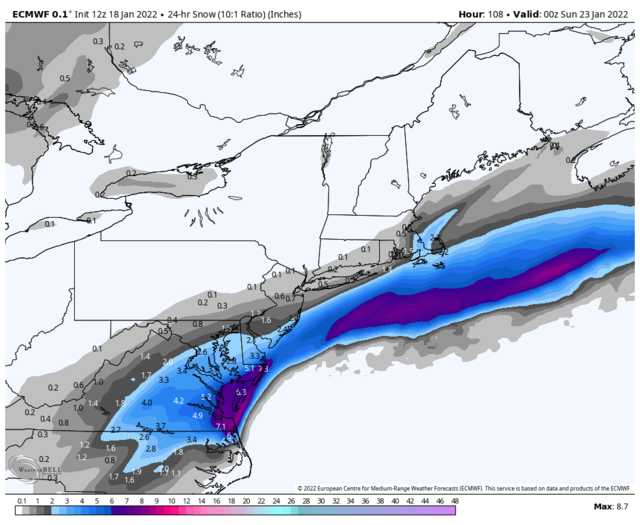
Wow, what happened to this model? GFS called last weekend's storm and now is on track to get this weekend's storm right too. Here's EURO snow map.


_________________
_______________________________________________________________________________________________________
CLICK HERE to view NJ Strong Snowstorm Classifications
moleson likes this post
 Re: January 22nd-23rd Storm
Boo hiss, lol, I fully expected this though hoped I did not see it happen. It could change again but I am guessing you guys may be right. My faith in the Euro is not what it used to be. Time for a upgrade there IMO.Frank_Wx wrote:Wow, what happened to this model? GFS called last weekend's storm and now is on track to get this weekend's storm right too. Here's EURO snow map.

jmanley32- Senior Enthusiast

- Posts : 20535
Reputation : 108
Join date : 2013-12-12
Age : 43
Location : Yonkers, NY
amugs likes this post
 Re: January 22nd-23rd Storm
There are so many pieces of energy that I'm not convinced any of the models have locked into the right solution. The Euro does slow things down this run.

bobjohnsonforthehall- Posts : 311
Reputation : 19
Join date : 2016-10-02
Location : Flemington NJ
 Re: January 22nd-23rd Storm
To my recollection, at least since 2016 when I started ‘tracking’ winter storms, there has not been one, I mean not a single solitary, storm that didn’t wiper effect it’s way thru most or all of the 5-6 days leading up to the event. I literally can’t think of one moderate to big event that did not get lost by the models prior to.
SENJsnowman- Senior Enthusiast

- Posts : 1189
Reputation : 61
Join date : 2017-01-06
Age : 51
Location : Bayville, NJ
 Re: January 22nd-23rd Storm
this is very true and I have not given up on it, not going to model hug.SENJsnowman wrote:To my recollection, at least since 2016 when I started ‘tracking’ winter storms, there has not been one, I mean not a single solitary, storm that didn’t wiper effect it’s way thru most or all of the 5-6 days leading up to the event. I literally can’t think of one moderate to big event that did not get lost by the models prior to.

jmanley32- Senior Enthusiast

- Posts : 20535
Reputation : 108
Join date : 2013-12-12
Age : 43
Location : Yonkers, NY
 Re: January 22nd-23rd Storm
SENJsnowman wrote:To my recollection, at least since 2016 when I started ‘tracking’ winter storms, there has not been one, I mean not a single solitary, storm that didn’t wiper effect it’s way thru most or all of the 5-6 days leading up to the event. I literally can’t think of one moderate to big event that did not get lost by the models prior to.
You are right and especially with phasing systems that are very fickle to forecast. They are always high risk/reward type deals. No one should be surprised if this comes back on the table.
heehaw453- Advanced Forecaster

- Posts : 3906
Reputation : 86
Join date : 2014-01-20
Location : Bedminster Township, PA Elevation 600' ASL
 Re: January 22nd-23rd Storm
SENJsnowman wrote:To my recollection, at least since 2016 when I started ‘tracking’ winter storms, there has not been one, I mean not a single solitary, storm that didn’t wiper effect it’s way thru most or all of the 5-6 days leading up to the event. I literally can’t think of one moderate to big event that did not get lost by the models prior to.
The difference here I think is the Euro was the only model that had this storm affecting most of the forum. It was an outlier and now seems to be conforming to the others. Hopefully I'm dead wrong.

CPcantmeasuresnow- Wx Statistician Guru

- Posts : 7274
Reputation : 230
Join date : 2013-01-07
Age : 103
Location : Eastern Orange County, NY
moleson likes this post
 Re: January 22nd-23rd Storm
CPcantmeasuresnow wrote:SENJsnowman wrote:To my recollection, at least since 2016 when I started ‘tracking’ winter storms, there has not been one, I mean not a single solitary, storm that didn’t wiper effect it’s way thru most or all of the 5-6 days leading up to the event. I literally can’t think of one moderate to big event that did not get lost by the models prior to.
The difference here I think is the Euro was the only model that had this storm affecting most of the forum. It was an outlier and now seems to be conforming to the others. Hopefully I'm dead wrong.
Hey CP, I think you are short on your snow totals to date.We had 4 inches from the storm LI got 8 or 9.Do you have that in your totals?

docstox12- Wx Statistician Guru

- Posts : 8530
Reputation : 222
Join date : 2013-01-07
Age : 73
Location : Monroe NY
 Re: January 22nd-23rd Storm
docstox12 wrote:CPcantmeasuresnow wrote:SENJsnowman wrote:To my recollection, at least since 2016 when I started ‘tracking’ winter storms, there has not been one, I mean not a single solitary, storm that didn’t wiper effect it’s way thru most or all of the 5-6 days leading up to the event. I literally can’t think of one moderate to big event that did not get lost by the models prior to.
The difference here I think is the Euro was the only model that had this storm affecting most of the forum. It was an outlier and now seems to be conforming to the others. Hopefully I'm dead wrong.
Hey CP, I think you are short on your snow totals to date.We had 4 inches from the storm LI got 8 or 9.Do you have that in your totals?
Doc I'm at 11.0 even. I'll have to update my signature.
Plus 11 straight days of snowpack, the bigger number as far as I'm concerned. Would love to see that run through Mid March, like last years snowpack. Of course that was helped immensely by the 28 inch storm of Feb 1-3, wouldn't mind another of those at some point this season.
Last edited by CPcantmeasuresnow on Tue Jan 18, 2022 4:20 pm; edited 1 time in total

CPcantmeasuresnow- Wx Statistician Guru

- Posts : 7274
Reputation : 230
Join date : 2013-01-07
Age : 103
Location : Eastern Orange County, NY
 Re: January 22nd-23rd Storm
CPcantmeasuresnow wrote:docstox12 wrote:CPcantmeasuresnow wrote:SENJsnowman wrote:To my recollection, at least since 2016 when I started ‘tracking’ winter storms, there has not been one, I mean not a single solitary, storm that didn’t wiper effect it’s way thru most or all of the 5-6 days leading up to the event. I literally can’t think of one moderate to big event that did not get lost by the models prior to.
The difference here I think is the Euro was the only model that had this storm affecting most of the forum. It was an outlier and now seems to be conforming to the others. Hopefully I'm dead wrong.
Hey CP, I think you are short on your snow totals to date.We had 4 inches from the storm LI got 8 or 9.Do you have that in your totals?
Doc I'm at 11.0 even. I'll have to update my signature.
Roger that!

docstox12- Wx Statistician Guru

- Posts : 8530
Reputation : 222
Join date : 2013-01-07
Age : 73
Location : Monroe NY
 Re: January 22nd-23rd Storm
Take NAM FWIW at 18Z, but it's not impressive for a decent event. Lots of confluence dampening EC heights so that isn't a look of a storm riding up the coast to me. Again NAM at hour 84 is like GFS at hour 168 not too reliable...
heehaw453- Advanced Forecaster

- Posts : 3906
Reputation : 86
Join date : 2014-01-20
Location : Bedminster Township, PA Elevation 600' ASL
 Re: January 22nd-23rd Storm
Lets cross out fingers this is a windshield wiper and not a trend that the Goofus was right.heehaw453 wrote:Take NAM FWIW at 18Z, but it's not impressive for a decent event. Lots of confluence dampening EC heights so that isn't a look of a storm riding up the coast to me. Again NAM at hour 84 is like GFS at hour 168 not too reliable...

jmanley32- Senior Enthusiast

- Posts : 20535
Reputation : 108
Join date : 2013-12-12
Age : 43
Location : Yonkers, NY
 Re: January 22nd-23rd Storm
Just like when we get a NW jog we get all excited by one model and then another follows and they then jog South and then NW and then... it is a dance we do everytime since I began tracking since the great storms of 1977-78. Models are 1 gazillion x better but we see this dance. No trend yet so glass is half filled. You may disagree which is fine but until we see a few more runs then we moved ahead.
And 18 EPS members have a Westward Lean. 16 are OTS.

And 18 EPS members have a Westward Lean. 16 are OTS.

_________________
Mugs
AKA:King: Snow Weenie
Self Proclaimed
WINTER 2014-15 : 55.12" +.02 for 6 coatings (avg. 35")
WINTER 2015-16 Total - 29.8" (Avg 35")
WINTER 2016-17 : 39.5" so far

amugs- Advanced Forecaster - Mod

- Posts : 15095
Reputation : 213
Join date : 2013-01-07
Age : 54
Location : Hillsdale,NJ
 Re: January 22nd-23rd Storm
Well NWS just put the Kabosh on this one!!
Most long range models
take the low well out to sea Saturday, with no real impacts to the
area. The ECMWF had been more of a direct impact, however the newer
model run trended farther south and east, which is in line with the
other long range models. Additionally, less than 25% of the GEFS
members show any real impact from the storm. Given the uncertainty,
stayed close to the NBM for POPs, but they will likely trend
downward in subsequent forecast if the more southeastern trend in
the track continues.
Close it up peeps the Weather gurus have spoken. Done deal onto the next fantasy threat!
_________________
Mugs
AKA:King: Snow Weenie
Self Proclaimed
WINTER 2014-15 : 55.12" +.02 for 6 coatings (avg. 35")
WINTER 2015-16 Total - 29.8" (Avg 35")
WINTER 2016-17 : 39.5" so far

amugs- Advanced Forecaster - Mod

- Posts : 15095
Reputation : 213
Join date : 2013-01-07
Age : 54
Location : Hillsdale,NJ
 Re: January 22nd-23rd Storm
amugs wrote:Well NWS just put the Kabosh on this one!!
Most long range models
take the low well out to sea Saturday, with no real impacts to the
area. The ECMWF had been more of a direct impact, however the newer
model run trended farther south and east, which is in line with the
other long range models. Additionally, less than 25% of the GEFS
members show any real impact from the storm. Given the uncertainty,
stayed close to the NBM for POPs, but they will likely trend
downward in subsequent forecast if the more southeastern trend in
the track continues.
Close it up peeps the Weather gurus have spoken. Done deal onto the next fantasy threat!
New rule, Frank isn't allowed to make a new thread until 24hr before storm

mikeypizano- Pro Enthusiast

- Posts : 1118
Reputation : 66
Join date : 2017-01-05
Age : 35
Location : Wilkes-Barre/Scranton, PA
amugs, jmanley32 and Sparky Sparticles like this post
 Re: January 22nd-23rd Storm
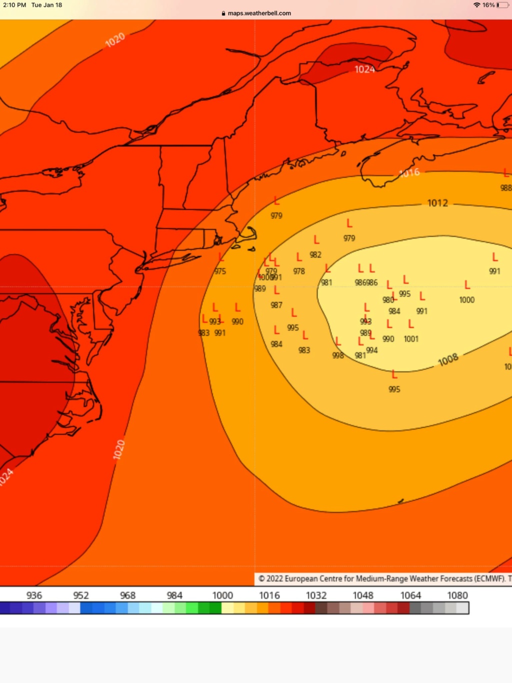
Look at this: Must have seen what I saw here LOL found off Twitter
Agree with all of this. There is a heavy lean west on the EPS with just under half the members coming in near the BM. https://t.co/9yaGF89OdX
— Mike Barletta (@MikeBWeather) January 18, 2022
_________________
Mugs
AKA:King: Snow Weenie
Self Proclaimed
WINTER 2014-15 : 55.12" +.02 for 6 coatings (avg. 35")
WINTER 2015-16 Total - 29.8" (Avg 35")
WINTER 2016-17 : 39.5" so far

amugs- Advanced Forecaster - Mod

- Posts : 15095
Reputation : 213
Join date : 2013-01-07
Age : 54
Location : Hillsdale,NJ
Page 1 of 2 • 1, 2 
Permissions in this forum:
You cannot reply to topics in this forum|
|
|

 Home
Home