May 2022 Observations and Discussions
+12
sroc4
docstox12
aiannone
Dunnzoo
Quietace
phil155
weatherwatchermom
dkodgis
jmanley32
amugs
frank 638
billg315
16 posters
Page 3 of 3 •  1, 2, 3
 Re: May 2022 Observations and Discussions
Hello folks, just passing thru. Apparently we will be jumping right into July this weekend. As the song goes
I prefer to ease into it as opposed to the sudden "in your face" option given the choice
I prefer to ease into it as opposed to the sudden "in your face" option given the choice
GreyBeard- Senior Enthusiast

- Posts : 725
Join date : 2014-02-12
 Re: May 2022 Observations and Discussions
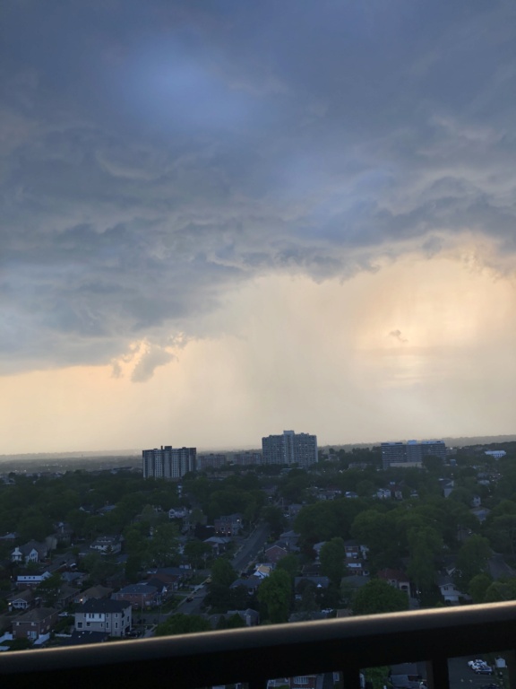
Very surprised by how quiet it is in here considering the tornado watch and severe thunderstorm warnings. I guess the bust the other day has folks unimpressed with this system
phil155- Pro Enthusiast

- Posts : 483
Join date : 2019-12-16
 Re: May 2022 Observations and Discussions
Rain popped up without warning at 2 pm and now at 4 pm. For this past week including today, 4 inches of rain.

dkodgis- Senior Enthusiast

- Posts : 2560
Reputation : 98
Join date : 2013-12-29
 Re: May 2022 Observations and Discussions
Nothing crazy over by me Just had moderate to heavy rain for a while couple  and that was it
frank 638- Senior Enthusiast

- Posts : 2843
Reputation : 37
Join date : 2016-01-01
Age : 40
Location : bronx ny
 Re: May 2022 Observations and Discussions
Happy first day of summer (temperature-wise at least)! It is always good for the warmth to come in before next weekend. We will see how high we go today, but it is going to be a.....warm....day. See below for details.
Below is this morning's sounding from KALB. You can estimate the daily high temperature during a dry, cloudless day using the morning sounding. Using the full dry adiabatic mix-out temp on the ALB sounding (In simple terms: taking the low-level warm nose and following the dry adiabat down to the SFC, essentially the level the lower atmosphere can mix out to via turbulent eddies, the top of the boundary layer (see Chapter 4 of Mesoscale Meteorology in Midlatitudes by Markowski and Richardson https://onlinelibrary.wiley.com/doi/book/10.1002/9780470682104 for more info)), was upper-30s C from about 800 hPa with SSW flow with more WAA in the mid-levels expected this morning. There will be a few 100s popping up today if we do not get any hinderance.

Below is this morning's sounding from KALB. You can estimate the daily high temperature during a dry, cloudless day using the morning sounding. Using the full dry adiabatic mix-out temp on the ALB sounding (In simple terms: taking the low-level warm nose and following the dry adiabat down to the SFC, essentially the level the lower atmosphere can mix out to via turbulent eddies, the top of the boundary layer (see Chapter 4 of Mesoscale Meteorology in Midlatitudes by Markowski and Richardson https://onlinelibrary.wiley.com/doi/book/10.1002/9780470682104 for more info)), was upper-30s C from about 800 hPa with SSW flow with more WAA in the mid-levels expected this morning. There will be a few 100s popping up today if we do not get any hinderance.

Quietace- Meteorologist - Mod

- Posts : 3689
Reputation : 33
Join date : 2013-01-07
Age : 27
Location : Point Pleasant, NJ
kalleg likes this post
 Re: May 2022 Observations and Discussions
Hit 92.5 today, so uncomfortable! Thankfully the house was closed up since yesterday in anticipation of the storms so the house kept cool without the AC. Not so sure we'll get through tomorrow without it.
_________________
Janet
Snowfall winter of 2023-2024 17.5"
Snowfall winter of 2022-2023 6.0"
Snowfall winter of 2021-2022 17.6" 1" sleet 2/25/22
Snowfall winter of 2020-2021 51.1"
Snowfall winter of 2019-2020 8.5"
Snowfall winter of 2018-2019 25.1"
Snowfall winter of 2017-2018 51.9"
Snowfall winter of 2016-2017 45.6"
Snowfall winter of 2015-2016 29.5"
Snowfall winter of 2014-2015 50.55"
Snowfall winter of 2013-2014 66.5"
Dunnzoo- Senior Enthusiast - Mod

- Posts : 4904
Reputation : 68
Join date : 2013-01-11
Age : 62
Location : Westwood, NJ
 Re: May 2022 Observations and Discussions
It was 90 today. At 6:15 pm the sky opened up. 20 min of torrential rian that is still going on. My eyes popped out because I had just backwashed the pool filter so the water was an inch above the skimmer’s low notch. I just looked so this is 25 mins later from the backwash and the pool’s water level is up just past the very top of the skimmer and water is flooding out of the skimmer top. Like Gomer Pyle used to say when he was trying to change into that super hero: Shazam!

dkodgis- Senior Enthusiast

- Posts : 2560
Reputation : 98
Join date : 2013-12-29
 Re: May 2022 Observations and Discussions
Hit 90 today, and of course the SPC put out alerts and they mostly don't come to fruition. The SPC curse continues! Yes, some areas are seeing some strong cells, but overall, blah.
_________________
Janet
Snowfall winter of 2023-2024 17.5"
Snowfall winter of 2022-2023 6.0"
Snowfall winter of 2021-2022 17.6" 1" sleet 2/25/22
Snowfall winter of 2020-2021 51.1"
Snowfall winter of 2019-2020 8.5"
Snowfall winter of 2018-2019 25.1"
Snowfall winter of 2017-2018 51.9"
Snowfall winter of 2016-2017 45.6"
Snowfall winter of 2015-2016 29.5"
Snowfall winter of 2014-2015 50.55"
Snowfall winter of 2013-2014 66.5"

Dunnzoo- Senior Enthusiast - Mod

- Posts : 4904
Reputation : 68
Join date : 2013-01-11
Age : 62
Location : Westwood, NJ

1190ftalt- Pro Enthusiast

- Posts : 401
Reputation : 10
Join date : 2013-12-13
Location : Stillwater, NJ

1190ftalt- Pro Enthusiast

- Posts : 401
Reputation : 10
Join date : 2013-12-13
Location : Stillwater, NJ
 Re: May 2022 Observations and Discussions
Just missed a good thunderstorm  it’s north and east of me .but still a good lightning show
frank 638- Senior Enthusiast

- Posts : 2843
Reputation : 37
Join date : 2016-01-01
Age : 40
Location : bronx ny
 Re: May 2022 Observations and Discussions
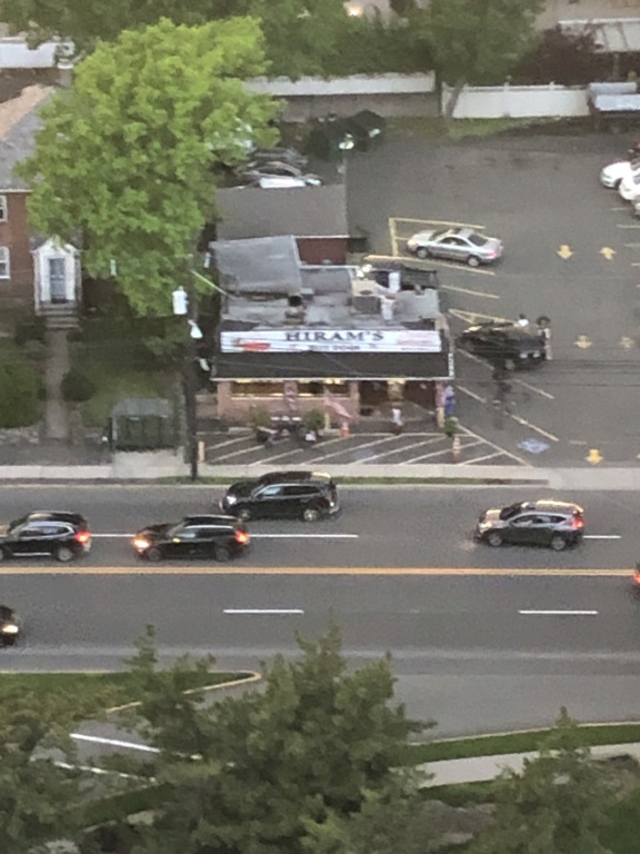
Great pictures.Hiram's has great hot dogs and fries.Used to stop there in 1968 when I worked part time at the local florist delivering.Was there a few years ago and the same great dogs and fries as '68!
54 degrees, partly cloudy, calm winds.Nice week coming up.

docstox12- Wx Statistician Guru

- Posts : 8530
Reputation : 222
Join date : 2013-01-07
Age : 73
Location : Monroe NY
 Re: May 2022 Observations and Discussions
docstox12 wrote:
Great pictures.Hiram's has great hot dogs and fries.Used to stop there in 1968 when I worked part time at the local florist delivering.Was there a few years ago and the same great dogs and fries as '68!
54 degrees, partly cloudy, calm winds.Nice week coming up.
oooooo, need to get to Hiram's soon! Great pictures. The rain missed us, just a few drops made it. 59* was my low this morning, great to have the windows open instead of AC
_________________
Janet
Snowfall winter of 2023-2024 17.5"
Snowfall winter of 2022-2023 6.0"
Snowfall winter of 2021-2022 17.6" 1" sleet 2/25/22
Snowfall winter of 2020-2021 51.1"
Snowfall winter of 2019-2020 8.5"
Snowfall winter of 2018-2019 25.1"
Snowfall winter of 2017-2018 51.9"
Snowfall winter of 2016-2017 45.6"
Snowfall winter of 2015-2016 29.5"
Snowfall winter of 2014-2015 50.55"
Snowfall winter of 2013-2014 66.5"

Dunnzoo- Senior Enthusiast - Mod

- Posts : 4904
Reputation : 68
Join date : 2013-01-11
Age : 62
Location : Westwood, NJ
 Re: May 2022 Observations and Discussions
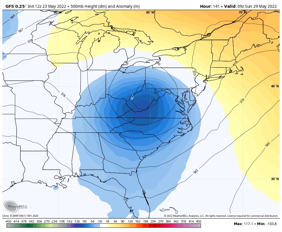
REALLY?? This would have been a nice snowstorm if a winter month!!

_________________
Mugs
AKA:King: Snow Weenie
Self Proclaimed
WINTER 2014-15 : 55.12" +.02 for 6 coatings (avg. 35")
WINTER 2015-16 Total - 29.8" (Avg 35")
WINTER 2016-17 : 39.5" so far

amugs- Advanced Forecaster - Mod

- Posts : 15095
Reputation : 213
Join date : 2013-01-07
Age : 54
Location : Hillsdale,NJ
 Re: May 2022 Observations and Discussions
SPC has us in slight risk for severe storms again. Odds that they are right? Always a jinx. Looks like the Mets game will be rained out, so I'll be in for a DH tomorrow.
_________________
Janet
Snowfall winter of 2023-2024 17.5"
Snowfall winter of 2022-2023 6.0"
Snowfall winter of 2021-2022 17.6" 1" sleet 2/25/22
Snowfall winter of 2020-2021 51.1"
Snowfall winter of 2019-2020 8.5"
Snowfall winter of 2018-2019 25.1"
Snowfall winter of 2017-2018 51.9"
Snowfall winter of 2016-2017 45.6"
Snowfall winter of 2015-2016 29.5"
Snowfall winter of 2014-2015 50.55"
Snowfall winter of 2013-2014 66.5"

Dunnzoo- Senior Enthusiast - Mod

- Posts : 4904
Reputation : 68
Join date : 2013-01-11
Age : 62
Location : Westwood, NJ
 Re: May 2022 Observations and Discussions
Sun popping out in Melville. Doubt storms will make it east of the city later today though.
_________________
-Alex Iannone-

aiannone- Senior Enthusiast - Mod

- Posts : 4815
Reputation : 92
Join date : 2013-01-07
Location : Saint James, LI (Northwest Suffolk Co.)
 Re: May 2022 Observations and Discussions
I have a suspicion today could be the day for at least some storms
phil155- Pro Enthusiast

- Posts : 483
Reputation : 4
Join date : 2019-12-16
 Re: May 2022 Observations and Discussions
Temp 73, dew 67, sun peeking out. If we get more sun, I could see some strong storms coming through, we'll see. The SPC alert is the KOD for NENJ.
_________________
Janet
Snowfall winter of 2023-2024 17.5"
Snowfall winter of 2022-2023 6.0"
Snowfall winter of 2021-2022 17.6" 1" sleet 2/25/22
Snowfall winter of 2020-2021 51.1"
Snowfall winter of 2019-2020 8.5"
Snowfall winter of 2018-2019 25.1"
Snowfall winter of 2017-2018 51.9"
Snowfall winter of 2016-2017 45.6"
Snowfall winter of 2015-2016 29.5"
Snowfall winter of 2014-2015 50.55"
Snowfall winter of 2013-2014 66.5"

Dunnzoo- Senior Enthusiast - Mod

- Posts : 4904
Reputation : 68
Join date : 2013-01-11
Age : 62
Location : Westwood, NJ
 Re: May 2022 Observations and Discussions
It just has the feeling outside that at the least we should see some heavy rains out of this today if not some stronger storms.
phil155- Pro Enthusiast

- Posts : 483
Reputation : 4
Join date : 2019-12-16
 Re: May 2022 Observations and Discussions
yawn, SPC KOD strikes again. Had some heavy rain (1") and a few gusts and a little lightning but that's it. We'll see what develops later tonight when the rest blows through, but not expecting much.
_________________
Janet
Snowfall winter of 2023-2024 17.5"
Snowfall winter of 2022-2023 6.0"
Snowfall winter of 2021-2022 17.6" 1" sleet 2/25/22
Snowfall winter of 2020-2021 51.1"
Snowfall winter of 2019-2020 8.5"
Snowfall winter of 2018-2019 25.1"
Snowfall winter of 2017-2018 51.9"
Snowfall winter of 2016-2017 45.6"
Snowfall winter of 2015-2016 29.5"
Snowfall winter of 2014-2015 50.55"
Snowfall winter of 2013-2014 66.5"

Dunnzoo- Senior Enthusiast - Mod

- Posts : 4904
Reputation : 68
Join date : 2013-01-11
Age : 62
Location : Westwood, NJ
 Re: May 2022 Observations and Discussions
I don't even get excited anymore and have been so busy focused on other things often I do not know if there is even SPC severe risk in the area haha. My job does not allow me 1 second to check the weather but I guess it is a good thing, plus I will know what it is doing have a nice big ceiling to shelf level glass windows facing Huguenot St. in New Rochelle right above Monroe college. I have buildings across from me but i can see the sky to the right.Dunnzoo wrote:yawn, SPC KOD strikes again. Had some heavy rain (1") and a few gusts and a little lightning but that's it. We'll see what develops later tonight when the rest blows through, but not expecting much.

jmanley32- Senior Enthusiast

- Posts : 20535
Reputation : 108
Join date : 2013-12-12
Age : 43
Location : Yonkers, NY
 Re: May 2022 Observations and Discussions
Finally some good relief To get rid of this heat I am guessing the back door cofront is coming on through feels nice and cool my type of weather
frank 638- Senior Enthusiast

- Posts : 2843
Reputation : 37
Join date : 2016-01-01
Age : 40
Location : bronx ny
 Re: May 2022 Observations and Discussions
This is interesting. NWS says the temps are dropping, so they've issued the rare "grab a hoodie" watch. Love the last line.
Special Weather Statement
from Tue, May 31, 10:07 PM EDT to Tue, May 31, 10:45 PM EDT
Special Weather Statement issued May 31 at 10:07PM EDT by NWS New York City - Upton
...BACK DOOR COLD FRONT BRINGING A RAPID TEMPERATURE DROP TO NEW YORK CITY, NORTHEAST NEW JERSEY AND THE LOWER HUDSON VALLEY THIS EVENING...
At 950 PM, surface observations and Doppler radar were tracking a strong back door cold front extending from Wallkill to Passaic to Jersey City to near Coney Island. Movement was southwest at 10 mph.
Temperatures after the frontal passage will fall rapidly. At LaGuardia Airport the temperature fell from 91 degrees at 805 PM to 70 at 820 PM. Similar drops through the 70s and into the 60s should be expected late this evening.
The front should pass through...
Harrison and The Verrazano Narrows Bridge around 1010 PM.
Bayonne and Wayne around 1015 PM.
Newark around 1020 PM.
Bloomfield around 1030 PM.
Todt Hill and Port Richmond around 1035 PM.
Elizabeth and Oakwood around 1045 PM.
Caldwell and Fairfield around 1055 PM.
Orange around 1100 PM.
Union around 1105 PM.
Linden around 1110 PM.
If heading outdoors, consider dressing for suddenly cooler weather this evening.

essexcountypete- Pro Enthusiast

- Posts : 783
Reputation : 12
Join date : 2013-12-09
Location : Bloomfield, NJ
 Re: May 2022 Observations and Discussions
essexcountypete wrote:This is interesting. NWS says the temps are dropping, so they've issued the rare "grab a hoodie" watch. Love the last line.
Special Weather Statement
from Tue, May 31, 10:07 PM EDT to Tue, May 31, 10:45 PM EDT
Special Weather Statement issued May 31 at 10:07PM EDT by NWS New York City - Upton
...BACK DOOR COLD FRONT BRINGING A RAPID TEMPERATURE DROP TO NEW YORK CITY, NORTHEAST NEW JERSEY AND THE LOWER HUDSON VALLEY THIS EVENING...
At 950 PM, surface observations and Doppler radar were tracking a strong back door cold front extending from Wallkill to Passaic to Jersey City to near Coney Island. Movement was southwest at 10 mph.
Temperatures after the frontal passage will fall rapidly. At LaGuardia Airport the temperature fell from 91 degrees at 805 PM to 70 at 820 PM. Similar drops through the 70s and into the 60s should be expected late this evening.
The front should pass through...
Harrison and The Verrazano Narrows Bridge around 1010 PM.
Bayonne and Wayne around 1015 PM.
Newark around 1020 PM.
Bloomfield around 1030 PM.
Todt Hill and Port Richmond around 1035 PM.
Elizabeth and Oakwood around 1045 PM.
Caldwell and Fairfield around 1055 PM.
Orange around 1100 PM.
Union around 1105 PM.
Linden around 1110 PM.
If heading outdoors, consider dressing for suddenly cooler weather this evening.
I was standing outside on a sideline watching my kids soccer practice last night thinking how nice of an evening it was with a nice warm breeze. Then literally like a switch the temp on the wind dramatically cooled within minutes and it def got downright chilly.
_________________
"In weather and in life, there's no winning and losing; there's only winning and learning."
WINTER 2012/2013 TOTALS 43.65"WINTER 2017/2018 TOTALS 62.85" WINTER 2022/2023 TOTALS 4.9"
WINTER 2013/2014 TOTALS 64.85"WINTER 2018/2019 TOTALS 14.25" WINTER 2023/2024 TOTALS 13.1"
WINTER 2014/2015 TOTALS 71.20"WINTER 2019/2020 TOTALS 6.35"
WINTER 2015/2016 TOTALS 35.00"WINTER 2020/2021 TOTALS 37.75"
WINTER 2016/2017 TOTALS 42.25"WINTER 2021/2022 TOTALS 31.65"

sroc4- Admin

- Posts : 8354
Reputation : 302
Join date : 2013-01-07
Location : Wading River, LI
amugs likes this post
 Re: May 2022 Observations and Discussions
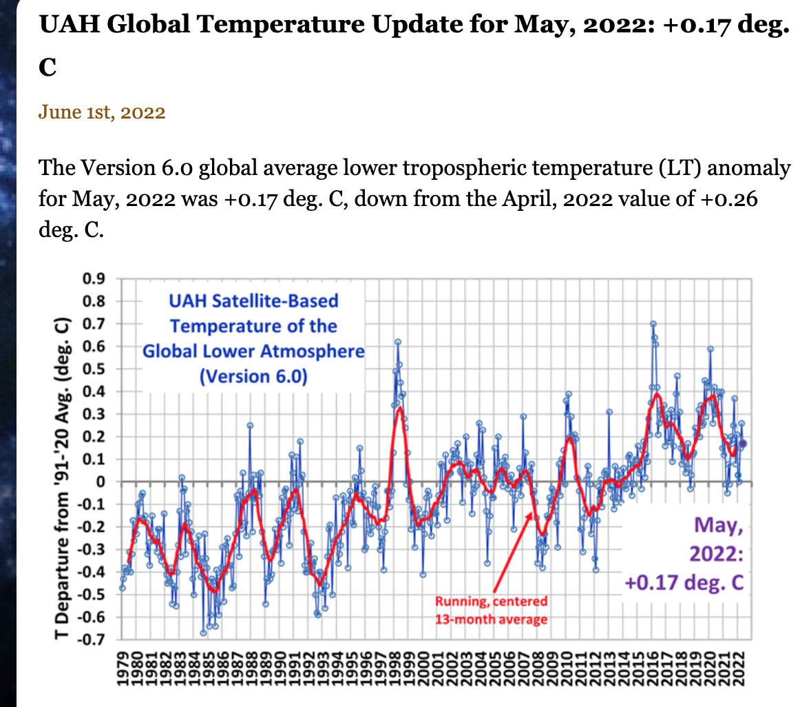
Just like we had this winter - extreme temp drops. All part o fthe GSM - Grand Solar Minimum Cycle we are entering. More extreme weather like tihs and otehr weather events to come for sure .
Basically flat again
Basically flat again

_________________
Mugs
AKA:King: Snow Weenie
Self Proclaimed
WINTER 2014-15 : 55.12" +.02 for 6 coatings (avg. 35")
WINTER 2015-16 Total - 29.8" (Avg 35")
WINTER 2016-17 : 39.5" so far

amugs- Advanced Forecaster - Mod

- Posts : 15095
Reputation : 213
Join date : 2013-01-07
Age : 54
Location : Hillsdale,NJ
Page 3 of 3 •  1, 2, 3
Permissions in this forum:
You cannot reply to topics in this forum|
|
|

 Home
Home

