
 Search
Long Range Thread 25.0
Page 20 of 40 •  1 ... 11 ... 19, 20, 21 ... 30 ... 40
 ![]()
Re: Long Range Thread 25.0
![]() by sroc4 Fri Dec 30, 2022 8:12 am
by sroc4 Fri Dec 30, 2022 8:12 am
heehaw453 wrote:This setup is rather ugly for January 6, but there is a trough shown and if the TPV lobe in Baffin Bay presses a bit more then enough cold air can be tapped into. GFS has been showing this time frame as an interesting period. As of now I doubt it and should wait another few days before we see if this is a realized threat. Would love to see the luck change a little bit before mid-month. I usually find if things are going to turn around we start getting something out of these difficult setups.

Quick little rough and tumble discussion about this. I think you hit the nail on the head by focusing on this piece of the puzzle, ie: the TPV. Feel free everyone to take a peek at the surface maps for Jan 6-7th on the 06z GFS this morning and do what you want with it. Euro is miles away from that soln and I am going to explain why. Despite the fact that the time frame in question is still 7-8 days out the result of this will likely present itself before the weekend is out. Ill explain.
There is one main difference between the solns on the 6z GFS and 00z Euro.
First time stamp is representing approx late Sunday eve around 10pm. Notice both GFS and Euro have these same two pieces of energy, A & B, on the playing field in similar positions. These maps are inside 3days from now.


Now as we head on in time these two pieces of energy encounter a cross roads. By approx Tuesday mid morning around 10am you will see that both GFS and Euro are beginning to diverge in how they handle these two pieces of energy. In the first image on the GFS, energy A is dropping south and much of energy B is headed north. A & B are attempting to merge with one another here. On the other hand the Euro, while A is dipping south in a similar position to the GFS, much more of energy B is being held back; thus, the Euro wants to keep A & B separate from one another.


This cross roads appears to be critically important to the end result. Below now you will see that by late Wed Eve the GFS combines A&B to create a potent ULL now indicated by C. This is of critical importance. If this happens it immediately creates confluence in the NE CONUS which lends itself to a much colder soln. The result of this 500mb look on the surface is a strong LP and a strong HP in Canada, and more importantly a frontal boundary layer(blue line) that is allowed to dip to our south ahead of our system that comes along a day or two later. This positioning and strength of the HP and LP in Canada at the surface also shifts the wind direction in New England out of the N to NNE, more favorable for cold air infiltrations for our approaching system as Heehaw pointed out.


The Euro on the other hand, you can see at 500mb, keeps A & B separate from one another. The result at the surface is a weaker HP and LP to our north in Canada. Its orientation and weaker strength is such that there is more of a weak broad boundary layer that doesn't dip nearly as far south, and orients itself in a more W to E direction which lends itself to a wind direction in New England much more out of the ENE and a push from the SW as well because the boundary layer is weaker and further N.


This time frame between Tu and Wed will be critical in the outcome. As you can see in only a couple of days the models should start to converge on how A & B will handle this cross roads Tuesday am. If GFS begins to trend towards less interaction between A & B this threat is likely cooked. On the other hand if we start to see more and more interactions on the Euro well then maybe we grow legs. I want everyone to keep in mind however, even if there are interactions between these two pieces there is def still alot of work to do and details that need to come together pretty perfect to still work out. BUT in a time where the pattern is shitty in the words of he great Lloyd Christmas.......

WE TRACK!!

sroc4- Admin

- Posts : 8331
Join date : 2013-01-07
Frank_Wx, kalleg, crippo84 and heehaw453 like this post
Re: Long Range Thread 25.0
![]() by heehaw453 Fri Dec 30, 2022 11:37 am
by heehaw453 Fri Dec 30, 2022 11:37 am


heehaw453- Advanced Forecaster

- Posts : 3906
Join date : 2014-01-20
sroc4 and phil155 like this post
Re: Long Range Thread 25.0
![]() by amugs Fri Dec 30, 2022 5:08 pm
by amugs Fri Dec 30, 2022 5:08 pm
Lastly we have a MJO heading I to phase 7 and possibly 8 which would be a big plus as well for a trough to form over the EC.
Not writing off 6-8th time frame for its so far out.
_________________
Mugs
AKA:King: Snow Weenie
Self Proclaimed
WINTER 2014-15 : 55.12" +.02 for 6 coatings (avg. 35")
WINTER 2015-16 Total - 29.8" (Avg 35")
WINTER 2016-17 : 39.5" so far

amugs- Advanced Forecaster - Mod

- Posts : 15093
Reputation : 213
Join date : 2013-01-07
Age : 54
Location : Hillsdale,NJ
kalleg and CNWestMilford like this post
Re: Long Range Thread 25.0
![]() by heehaw453 Sat Dec 31, 2022 8:40 am
by heehaw453 Sat Dec 31, 2022 8:40 am

heehaw453- Advanced Forecaster
- Posts : 3906
Reputation : 86
Join date : 2014-01-20
Location : Bedminster Township, PA Elevation 600' ASL
Re: Long Range Thread 25.0
![]() by amugs Sat Dec 31, 2022 11:20 am
by amugs Sat Dec 31, 2022 11:20 am
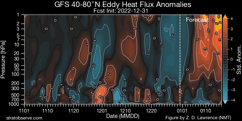
This is very good news for winter lovers.
[size=81]
[/size]Huge key is MJO. We went strong into the kiss of death phases. ( typical of bounceback events). but now heading back to VV pattern that encourages cold. pic.twitter.com/yXxrh5Ft9z
— Joe Bastardi (@BigJoeBastardi) December 31, 2022
[size=81]Big elongation of the PV starting the 7th. Good news here as well. Not 300 plus hours out. Keeps moving up in time.[/size]
[size=81]

[/size]
And lastly wow did the WV from the Tonga VEI 6 eruption last Jan 15th move fast. It is said to have reached the North Pole but need more confirmation to this. If true it'll be interesting to see how it effects our weather patterns going forward.
Last edited by amugs on Sat Dec 31, 2022 11:24 am; edited 1 time in total
_________________
Mugs
AKA:King: Snow Weenie
Self Proclaimed
WINTER 2014-15 : 55.12" +.02 for 6 coatings (avg. 35")
WINTER 2015-16 Total - 29.8" (Avg 35")
WINTER 2016-17 : 39.5" so far
amugs- Advanced Forecaster - Mod
- Posts : 15093
Reputation : 213
Join date : 2013-01-07
Age : 54
Location : Hillsdale,NJ
Re: Long Range Thread 25.0
![]() by sroc4 Sat Dec 31, 2022 11:22 am
by sroc4 Sat Dec 31, 2022 11:22 am

_________________
"In weather and in life, there's no winning and losing; there's only winning and learning."
WINTER 2012/2013 TOTALS 43.65"WINTER 2017/2018 TOTALS 62.85" WINTER 2022/2023 TOTALS 4.9"
WINTER 2013/2014 TOTALS 64.85"WINTER 2018/2019 TOTALS 14.25" WINTER 2023/2024 TOTALS 13.1"
WINTER 2014/2015 TOTALS 71.20"WINTER 2019/2020 TOTALS 6.35"
WINTER 2015/2016 TOTALS 35.00"WINTER 2020/2021 TOTALS 37.75"
WINTER 2016/2017 TOTALS 42.25"WINTER 2021/2022 TOTALS 31.65"

sroc4- Admin
- Posts : 8331
Reputation : 301
Join date : 2013-01-07
Location : Wading River, LI
Re: Long Range Thread 25.0
![]() by amugs Sat Dec 31, 2022 11:26 am
by amugs Sat Dec 31, 2022 11:26 am
_________________
Mugs
AKA:King: Snow Weenie
Self Proclaimed
WINTER 2014-15 : 55.12" +.02 for 6 coatings (avg. 35")
WINTER 2015-16 Total - 29.8" (Avg 35")
WINTER 2016-17 : 39.5" so far
amugs- Advanced Forecaster - Mod
- Posts : 15093
Reputation : 213
Join date : 2013-01-07
Age : 54
Location : Hillsdale,NJ
Re: Long Range Thread 25.0
![]() by heehaw453 Sat Dec 31, 2022 11:54 am
by heehaw453 Sat Dec 31, 2022 11:54 am

heehaw453- Advanced Forecaster
- Posts : 3906
Reputation : 86
Join date : 2014-01-20
Location : Bedminster Township, PA Elevation 600' ASL
Re: Long Range Thread 25.0
![]() by heehaw453 Sat Dec 31, 2022 12:01 pm
by heehaw453 Sat Dec 31, 2022 12:01 pm
 ndard hour run
heehaw453- Advanced Forecaster
- Posts : 3906
Reputation : 86
Join date : 2014-01-20
Location : Bedminster Township, PA Elevation 600' ASL
Re: Long Range Thread 25.0
![]() by heehaw453 Sat Dec 31, 2022 1:38 pm
by heehaw453 Sat Dec 31, 2022 1:38 pm
heehaw453- Advanced Forecaster
- Posts : 3906
Reputation : 86
Join date : 2014-01-20
Location : Bedminster Township, PA Elevation 600' ASL
SENJsnowman likes this post
Re: Long Range Thread 25.0
![]() by heehaw453 Sat Dec 31, 2022 2:38 pm
by heehaw453 Sat Dec 31, 2022 2:38 pm
It could be threats occur from 1/6-10 as the pattern transitions. This has the look of baroclinic zone potential on the EPS. Hard to imagine a cutter with that big ridge in the Hudson and James Bay.amugs wrote:The major "thaw" is upon us and don't fret or say we're done, throw in the towel talk, winter has just begun and we have Ural HP and Scan HP both working in tandem. This Urals HP usually correlates to colder weather to return to the East Coast about 10-14 days after it chills Eastern Siberia. All this tropical warmth actually is good and shall help with a PV elongation, stretch similar to what we just came out of from Dec 12th through 27th.
Lastly we have a MJO heading I to phase 7 and possibly 8 which would be a big plus as well for a trough to form over the EC.
Not writing off 6-8th time frame for its so far out.


heehaw453- Advanced Forecaster
- Posts : 3906
Reputation : 86
Join date : 2014-01-20
Location : Bedminster Township, PA Elevation 600' ASL
Re: Long Range Thread 25.0
![]() by amugs Sat Dec 31, 2022 2:44 pm
by amugs Sat Dec 31, 2022 2:44 pm
_________________
Mugs
AKA:King: Snow Weenie
Self Proclaimed
WINTER 2014-15 : 55.12" +.02 for 6 coatings (avg. 35")
WINTER 2015-16 Total - 29.8" (Avg 35")
WINTER 2016-17 : 39.5" so far
amugs- Advanced Forecaster - Mod
- Posts : 15093
Reputation : 213
Join date : 2013-01-07
Age : 54
Location : Hillsdale,NJ
Re: Long Range Thread 25.0
![]() by sroc4 Sat Dec 31, 2022 2:51 pm
by sroc4 Sat Dec 31, 2022 2:51 pm

_________________
"In weather and in life, there's no winning and losing; there's only winning and learning."
WINTER 2012/2013 TOTALS 43.65"WINTER 2017/2018 TOTALS 62.85" WINTER 2022/2023 TOTALS 4.9"
WINTER 2013/2014 TOTALS 64.85"WINTER 2018/2019 TOTALS 14.25" WINTER 2023/2024 TOTALS 13.1"
WINTER 2014/2015 TOTALS 71.20"WINTER 2019/2020 TOTALS 6.35"
WINTER 2015/2016 TOTALS 35.00"WINTER 2020/2021 TOTALS 37.75"
WINTER 2016/2017 TOTALS 42.25"WINTER 2021/2022 TOTALS 31.65"
sroc4- Admin
- Posts : 8331
Reputation : 301
Join date : 2013-01-07
Location : Wading River, LI
Re: Long Range Thread 25.0
![]() by amugs Sat Dec 31, 2022 2:52 pm
by amugs Sat Dec 31, 2022 2:52 pm

_________________
Mugs
AKA:King: Snow Weenie
Self Proclaimed
WINTER 2014-15 : 55.12" +.02 for 6 coatings (avg. 35")
WINTER 2015-16 Total - 29.8" (Avg 35")
WINTER 2016-17 : 39.5" so far
amugs- Advanced Forecaster - Mod
- Posts : 15093
Reputation : 213
Join date : 2013-01-07
Age : 54
Location : Hillsdale,NJ
sroc4 and Grselig like this post
Re: Long Range Thread 25.0
![]() by amugs Sat Dec 31, 2022 11:34 pm
by amugs Sat Dec 31, 2022 11:34 pm
_________________
Mugs
AKA:King: Snow Weenie
Self Proclaimed
WINTER 2014-15 : 55.12" +.02 for 6 coatings (avg. 35")
WINTER 2015-16 Total - 29.8" (Avg 35")
WINTER 2016-17 : 39.5" so far
amugs- Advanced Forecaster - Mod
- Posts : 15093
Reputation : 213
Join date : 2013-01-07
Age : 54
Location : Hillsdale,NJ
Re: Long Range Thread 25.0
![]() by Frank_Wx Sun Jan 01, 2023 7:47 am
by Frank_Wx Sun Jan 01, 2023 7:47 am

_________________
_______________________________________________________________________________________________________
CLICK HERE to view NJ Strong Snowstorm Classifications

Frank_Wx- Godzilla Seeker
- Posts : 21305
Reputation : 328
Join date : 2013-01-05
Age : 31
Location : Jersey City, NJ -

Re: Long Range Thread 25.0
![]() by sroc4 Sun Jan 01, 2023 8:34 am
by sroc4 Sun Jan 01, 2023 8:34 am
_________________
"In weather and in life, there's no winning and losing; there's only winning and learning."
WINTER 2012/2013 TOTALS 43.65"WINTER 2017/2018 TOTALS 62.85" WINTER 2022/2023 TOTALS 4.9"
WINTER 2013/2014 TOTALS 64.85"WINTER 2018/2019 TOTALS 14.25" WINTER 2023/2024 TOTALS 13.1"
WINTER 2014/2015 TOTALS 71.20"WINTER 2019/2020 TOTALS 6.35"
WINTER 2015/2016 TOTALS 35.00"WINTER 2020/2021 TOTALS 37.75"
WINTER 2016/2017 TOTALS 42.25"WINTER 2021/2022 TOTALS 31.65"
sroc4- Admin
- Posts : 8331
Reputation : 301
Join date : 2013-01-07
Location : Wading River, LI
Re: Long Range Thread 25.0
![]() by heehaw453 Sun Jan 01, 2023 8:54 am
by heehaw453 Sun Jan 01, 2023 8:54 am
Looking at last night's Euro 00Z. If this ULL can be closed off and slide underneath the area, then I can see c-2" snowfall possible. If it's not closed I don't think anything from this.sroc4 wrote:At 500 It’s close to a decent mild to moderate event. And at this lead time, 6days +\- , models are right where they need to be.
Edit. As I say if our fortunes are truly turning we get something out of something like this.

heehaw453- Advanced Forecaster
- Posts : 3906
Reputation : 86
Join date : 2014-01-20
Location : Bedminster Township, PA Elevation 600' ASL
sroc4 and MattyICE like this post
Re: Long Range Thread 25.0
![]() by sroc4 Sun Jan 01, 2023 9:34 am
by sroc4 Sun Jan 01, 2023 9:34 am
heehaw453 wrote:Looking at last night's Euro 00Z. If this ULL can be closed off and slide underneath the area, then I can see c-2" snowfall possible. If it's not closed I don't think anything from this.sroc4 wrote:At 500 It’s close to a decent mild to moderate event. And at this lead time, 6days +\- , models are right where they need to be.
Edit. As I say if our fortunes are truly turning we get something out of something like this.
There still seems like a couple of ways this can work out. 06z GFS If that lead energy is 6-8hrs slower, or if the trailing energy over the western GL is 6-8hrs faster we get some phasing; at least verbatim on this run.

_________________
"In weather and in life, there's no winning and losing; there's only winning and learning."
WINTER 2012/2013 TOTALS 43.65"WINTER 2017/2018 TOTALS 62.85" WINTER 2022/2023 TOTALS 4.9"
WINTER 2013/2014 TOTALS 64.85"WINTER 2018/2019 TOTALS 14.25" WINTER 2023/2024 TOTALS 13.1"
WINTER 2014/2015 TOTALS 71.20"WINTER 2019/2020 TOTALS 6.35"
WINTER 2015/2016 TOTALS 35.00"WINTER 2020/2021 TOTALS 37.75"
WINTER 2016/2017 TOTALS 42.25"WINTER 2021/2022 TOTALS 31.65"
sroc4- Admin
- Posts : 8331
Reputation : 301
Join date : 2013-01-07
Location : Wading River, LI
MattyICE likes this post
Re: Long Range Thread 25.0
![]() by Frank_Wx Sun Jan 01, 2023 10:10 am
by Frank_Wx Sun Jan 01, 2023 10:10 am
sroc4 wrote:heehaw453 wrote:Looking at last night's Euro 00Z. If this ULL can be closed off and slide underneath the area, then I can see c-2" snowfall possible. If it's not closed I don't think anything from this.sroc4 wrote:At 500 It’s close to a decent mild to moderate event. And at this lead time, 6days +\- , models are right where they need to be.
Edit. As I say if our fortunes are truly turning we get something out of something like this.
There still seems like a couple of ways this can work out. 06z GFS If that lead energy is 6-8hrs slower, or if the trailing energy over the western GL is 6-8hrs faster we get some phasing; at least verbatim on this run.
Yes, but look at what’s happening on the west coast. Pretty terrible ridge axis ahead of a raging PAC jet. For what you’re saying to come true would require big changes out west.
_________________
_______________________________________________________________________________________________________
CLICK HERE to view NJ Strong Snowstorm Classifications
Frank_Wx- Godzilla Seeker
- Posts : 21305
Reputation : 328
Join date : 2013-01-05
Age : 31
Location : Jersey City, NJ -
Re: Long Range Thread 25.0
![]() by sroc4 Sun Jan 01, 2023 10:19 am
by sroc4 Sun Jan 01, 2023 10:19 am
Frank_Wx wrote:sroc4 wrote:heehaw453 wrote:Looking at last night's Euro 00Z. If this ULL can be closed off and slide underneath the area, then I can see c-2" snowfall possible. If it's not closed I don't think anything from this.sroc4 wrote:At 500 It’s close to a decent mild to moderate event. And at this lead time, 6days +\- , models are right where they need to be.
Edit. As I say if our fortunes are truly turning we get something out of something like this.
There still seems like a couple of ways this can work out. 06z GFS If that lead energy is 6-8hrs slower, or if the trailing energy over the western GL is 6-8hrs faster we get some phasing; at least verbatim on this run.
Yes, but look at what’s happening on the west coast. Pretty terrible ridge axis ahead of a raging PAC jet. For what you’re saying to come true would require big changes out west.
Shhhhh. You’re ruining it Frank. Lol. I hear what you’re saying and 100% recognize the challenges. The WC has been out Achilles heal even when there was high latitude blocking in place. Heck it’s been the achillies heal for several yrs.
_________________
"In weather and in life, there's no winning and losing; there's only winning and learning."
WINTER 2012/2013 TOTALS 43.65"WINTER 2017/2018 TOTALS 62.85" WINTER 2022/2023 TOTALS 4.9"
WINTER 2013/2014 TOTALS 64.85"WINTER 2018/2019 TOTALS 14.25" WINTER 2023/2024 TOTALS 13.1"
WINTER 2014/2015 TOTALS 71.20"WINTER 2019/2020 TOTALS 6.35"
WINTER 2015/2016 TOTALS 35.00"WINTER 2020/2021 TOTALS 37.75"
WINTER 2016/2017 TOTALS 42.25"WINTER 2021/2022 TOTALS 31.65"
sroc4- Admin
- Posts : 8331
Reputation : 301
Join date : 2013-01-07
Location : Wading River, LI
Frank_Wx likes this post
Re: Long Range Thread 25.0
![]() by heehaw453 Sun Jan 01, 2023 11:14 am
by heehaw453 Sun Jan 01, 2023 11:14 am

heehaw453- Advanced Forecaster
- Posts : 3906
Reputation : 86
Join date : 2014-01-20
Location : Bedminster Township, PA Elevation 600' ASL
Re: Long Range Thread 25.0
![]() by sroc4 Sun Jan 01, 2023 11:19 am
by sroc4 Sun Jan 01, 2023 11:19 am
heehaw453 wrote:Close this ULL off faster and drop it about 50-100 miles south. It's darned close as modelled. What more can we ask but a chance I guess with this pattern.
All models have this omega like block move west to east over Canada Tuesday through Thursday. This combined with a piece of the TPV dropping southward that we’ve been noting creates just enough confluence in the NE to prevent a major storm cutting into the GL like pre Xmas. It shunts the energy southward instead. Then there is a big storm out over the Pac that pumps a short lived ridge that tries to drop a piece of energy into the backside of our lead energy. As usual timing is everything but i honestly like what I’ve seen over the past few days.
_________________
"In weather and in life, there's no winning and losing; there's only winning and learning."
WINTER 2012/2013 TOTALS 43.65"WINTER 2017/2018 TOTALS 62.85" WINTER 2022/2023 TOTALS 4.9"
WINTER 2013/2014 TOTALS 64.85"WINTER 2018/2019 TOTALS 14.25" WINTER 2023/2024 TOTALS 13.1"
WINTER 2014/2015 TOTALS 71.20"WINTER 2019/2020 TOTALS 6.35"
WINTER 2015/2016 TOTALS 35.00"WINTER 2020/2021 TOTALS 37.75"
WINTER 2016/2017 TOTALS 42.25"WINTER 2021/2022 TOTALS 31.65"
sroc4- Admin
- Posts : 8331
Reputation : 301
Join date : 2013-01-07
Location : Wading River, LI
SENJsnowman likes this post
Re: Long Range Thread 25.0
![]() by sroc4 Sun Jan 01, 2023 1:28 pm
by sroc4 Sun Jan 01, 2023 1:28 pm
_________________
"In weather and in life, there's no winning and losing; there's only winning and learning."
WINTER 2012/2013 TOTALS 43.65"WINTER 2017/2018 TOTALS 62.85" WINTER 2022/2023 TOTALS 4.9"
WINTER 2013/2014 TOTALS 64.85"WINTER 2018/2019 TOTALS 14.25" WINTER 2023/2024 TOTALS 13.1"
WINTER 2014/2015 TOTALS 71.20"WINTER 2019/2020 TOTALS 6.35"
WINTER 2015/2016 TOTALS 35.00"WINTER 2020/2021 TOTALS 37.75"
WINTER 2016/2017 TOTALS 42.25"WINTER 2021/2022 TOTALS 31.65"
sroc4- Admin
- Posts : 8331
Reputation : 301
Join date : 2013-01-07
Location : Wading River, LI
Re: Long Range Thread 25.0
![]() by heehaw453 Sun Jan 01, 2023 1:38 pm
by heehaw453 Sun Jan 01, 2023 1:38 pm
It does, but I disagree on not caring about the lower level temps. The ULL is what you'd want to see closed off and in WV. What is concerning to me is not seeing a banana high signature pumping in cold air. Had we had good cold air in place I'd by more optimistic for more than c-1".sroc4 wrote:500mb on euro conts to look decent. Don’t care about surface right now. Still big differences between gfs and euro leading up to Friday.


heehaw453- Advanced Forecaster
- Posts : 3906
Reputation : 86
Join date : 2014-01-20
Location : Bedminster Township, PA Elevation 600' ASL
Re: Long Range Thread 25.0
![]() by sroc4 Sun Jan 01, 2023 1:44 pm
by sroc4 Sun Jan 01, 2023 1:44 pm
_________________
"In weather and in life, there's no winning and losing; there's only winning and learning."
WINTER 2012/2013 TOTALS 43.65"WINTER 2017/2018 TOTALS 62.85" WINTER 2022/2023 TOTALS 4.9"
WINTER 2013/2014 TOTALS 64.85"WINTER 2018/2019 TOTALS 14.25" WINTER 2023/2024 TOTALS 13.1"
WINTER 2014/2015 TOTALS 71.20"WINTER 2019/2020 TOTALS 6.35"
WINTER 2015/2016 TOTALS 35.00"WINTER 2020/2021 TOTALS 37.75"
WINTER 2016/2017 TOTALS 42.25"WINTER 2021/2022 TOTALS 31.65"
sroc4- Admin
- Posts : 8331
Reputation : 301
Join date : 2013-01-07
Location : Wading River, LI
Re: Long Range Thread 25.0
![]() by amugs Sun Jan 01, 2023 2:36 pm
by amugs Sun Jan 01, 2023 2:36 pm
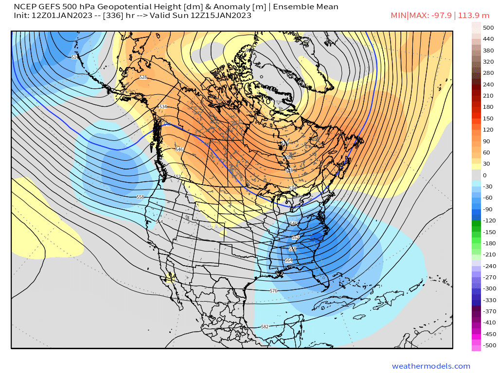
Good look here on LR GEFS - trough over EC, ridging out west and over the arctic
_________________
Mugs
AKA:King: Snow Weenie
Self Proclaimed
WINTER 2014-15 : 55.12" +.02 for 6 coatings (avg. 35")
WINTER 2015-16 Total - 29.8" (Avg 35")
WINTER 2016-17 : 39.5" so far
amugs- Advanced Forecaster - Mod
- Posts : 15093
Reputation : 213
Join date : 2013-01-07
Age : 54
Location : Hillsdale,NJ
Page 20 of 40 • 1 ... 11 ... 19, 20, 21 ... 30 ... 40 ![]()
|
|
|