
 Search
Long Range Thread 25.0
Page 21 of 40 •  1 ... 12 ... 20, 21, 22 ... 30 ... 40
 ![]()
sroc4- Admin

- Posts : 8331
Join date : 2013-01-07
Re: Long Range Thread 25.0
![]() by amugs Sun Jan 01, 2023 2:36 pm
by amugs Sun Jan 01, 2023 2:36 pm
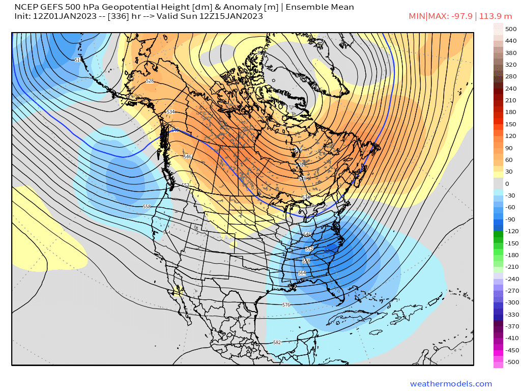
Good look here on LR GEFS - trough over EC, ridging out west and over the arctic
amugs- Advanced Forecaster - Mod

- Posts : 15093
Join date : 2013-01-07
Re: Long Range Thread 25.0
![]() by heehaw453 Sun Jan 01, 2023 5:36 pm
by heehaw453 Sun Jan 01, 2023 5:36 pm
heehaw453- Advanced Forecaster

- Posts : 3906
Reputation : 86
Join date : 2014-01-20
Location : Bedminster Township, PA Elevation 600' ASL
Re: Long Range Thread 25.0
![]() by Frank_Wx Sun Jan 01, 2023 7:35 pm
by Frank_Wx Sun Jan 01, 2023 7:35 pm
heehaw453 wrote:It does, but I disagree on not caring about the lower level temps. The ULL is what you'd want to see closed off and in WV. What is concerning to me is not seeing a banana high signature pumping in cold air. Had we had good cold air in place I'd by more optimistic for more than c-1".sroc4 wrote:500mb on euro conts to look decent. Don’t care about surface right now. Still big differences between gfs and euro leading up to Friday.


There’s too many s/w’s cutting to our west, hence temps in the upper 50s to 60s throughout most of this week. The deep negative out west kills this.
amugs wrote:
Good look here on LR GEFS - trough over EC, ridging out west and over the arctic
Gotta get the EPO negative again. I still can’t believe we’re on our third straight year of Nina. I don’t think I can handle a fourth straight (not gunna happen)
_________________
_______________________________________________________________________________________________________
CLICK HERE to view NJ Strong Snowstorm Classifications

Frank_Wx- Godzilla Seeker
- Posts : 21305
Reputation : 328
Join date : 2013-01-05
Age : 31
Location : Jersey City, NJ -

Re: Long Range Thread 25.0
![]() by amugs Sun Jan 01, 2023 8:34 pm
by amugs Sun Jan 01, 2023 8:34 pm
No 2 patterns are the same, but can be similar. I showed extensively on the Saturday summary why this winter may really rock Mid Jan on, rather than this back and forth we have had. Similar SST to 13-14 with N Pac hot spot pic.twitter.com/cCXhgBLvkc
— Joe Bastardi (@BigJoeBastardi) January 1, 2023
Hope it is close to this analog year
_________________
Mugs
AKA:King: Snow Weenie
Self Proclaimed
WINTER 2014-15 : 55.12" +.02 for 6 coatings (avg. 35")
WINTER 2015-16 Total - 29.8" (Avg 35")
WINTER 2016-17 : 39.5" so far

amugs- Advanced Forecaster - Mod
- Posts : 15093
Reputation : 213
Join date : 2013-01-07
Age : 54
Location : Hillsdale,NJ
Re: Long Range Thread 25.0
![]() by sroc4 Mon Jan 02, 2023 6:01 am
by sroc4 Mon Jan 02, 2023 6:01 am
_________________
"In weather and in life, there's no winning and losing; there's only winning and learning."
WINTER 2012/2013 TOTALS 43.65"WINTER 2017/2018 TOTALS 62.85" WINTER 2022/2023 TOTALS 4.9"
WINTER 2013/2014 TOTALS 64.85"WINTER 2018/2019 TOTALS 14.25" WINTER 2023/2024 TOTALS 13.1"
WINTER 2014/2015 TOTALS 71.20"WINTER 2019/2020 TOTALS 6.35"
WINTER 2015/2016 TOTALS 35.00"WINTER 2020/2021 TOTALS 37.75"
WINTER 2016/2017 TOTALS 42.25"WINTER 2021/2022 TOTALS 31.65"

sroc4- Admin
- Posts : 8331
Reputation : 301
Join date : 2013-01-07
Location : Wading River, LI
Re: Long Range Thread 25.0
![]() by docstox12 Mon Jan 02, 2023 8:53 am
by docstox12 Mon Jan 02, 2023 8:53 am

docstox12- Wx Statistician Guru

- Posts : 8506
Reputation : 222
Join date : 2013-01-07
Age : 73
Location : Monroe NY
Re: Long Range Thread 25.0
![]() by sroc4 Mon Jan 02, 2023 9:06 am
by sroc4 Mon Jan 02, 2023 9:06 am
docstox12 wrote:Curious as to why you think,Frank, there will not be a 4th straight Nina year next winter.Statistically remote but still possible.
As it is three in a row has only occurred a small handful of time in recorded History. As far as Im aware I dont think 4 has ever occured...in recorded history. I also think there was a dash of willing it not to happen in Franks statement because it has created winter weather lover challenges. But that's my guess. Ill let Frank speak for himself.
Last edited by sroc4 on Mon Jan 02, 2023 10:08 am; edited 1 time in total
_________________
"In weather and in life, there's no winning and losing; there's only winning and learning."
WINTER 2012/2013 TOTALS 43.65"WINTER 2017/2018 TOTALS 62.85" WINTER 2022/2023 TOTALS 4.9"
WINTER 2013/2014 TOTALS 64.85"WINTER 2018/2019 TOTALS 14.25" WINTER 2023/2024 TOTALS 13.1"
WINTER 2014/2015 TOTALS 71.20"WINTER 2019/2020 TOTALS 6.35"
WINTER 2015/2016 TOTALS 35.00"WINTER 2020/2021 TOTALS 37.75"
WINTER 2016/2017 TOTALS 42.25"WINTER 2021/2022 TOTALS 31.65"
sroc4- Admin
- Posts : 8331
Reputation : 301
Join date : 2013-01-07
Location : Wading River, LI
Re: Long Range Thread 25.0
![]() by Frank_Wx Mon Jan 02, 2023 9:09 am
by Frank_Wx Mon Jan 02, 2023 9:09 am
docstox12 wrote:Curious as to why you think,Frank, there will not be a 4th straight Nina year next winter.Statistically remote but still possible.
Aside from never witnessing four consecutive seasons of La Nina, there's evidence that points to ENSO-neutral conditions for this spring and POSSIBLY the emergence of El Nino for next winter.
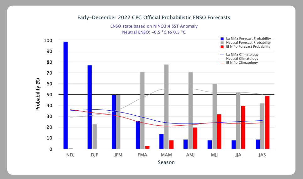
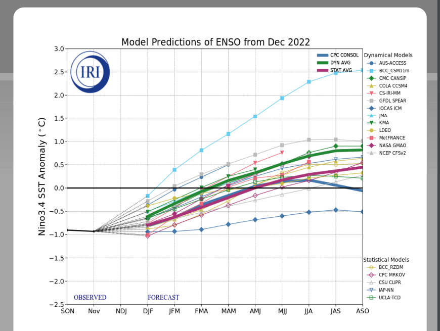
This is the oceans way of reacting to the moderate-high La Nina state it has felt for several years now.
_________________
_______________________________________________________________________________________________________
CLICK HERE to view NJ Strong Snowstorm Classifications
Frank_Wx- Godzilla Seeker
- Posts : 21305
Reputation : 328
Join date : 2013-01-05
Age : 31
Location : Jersey City, NJ -
Re: Long Range Thread 25.0
![]() by amugs Mon Jan 02, 2023 10:31 am
by amugs Mon Jan 02, 2023 10:31 am
If you look atthe maps that JB posted about SST analog - where are warm waters in the PAC?? Wehere the ring of fire underwater volcanoes are located. Willie Soon and ?? did a recent publication on this.
_________________
Mugs
AKA:King: Snow Weenie
Self Proclaimed
WINTER 2014-15 : 55.12" +.02 for 6 coatings (avg. 35")
WINTER 2015-16 Total - 29.8" (Avg 35")
WINTER 2016-17 : 39.5" so far
amugs- Advanced Forecaster - Mod
- Posts : 15093
Reputation : 213
Join date : 2013-01-07
Age : 54
Location : Hillsdale,NJ
Re: Long Range Thread 25.0
![]() by heehaw453 Mon Jan 02, 2023 10:36 am
by heehaw453 Mon Jan 02, 2023 10:36 am
heehaw453- Advanced Forecaster
- Posts : 3906
Reputation : 86
Join date : 2014-01-20
Location : Bedminster Township, PA Elevation 600' ASL
Re: Long Range Thread 25.0
![]() by amugs Mon Jan 02, 2023 10:37 am
by amugs Mon Jan 02, 2023 10:37 am
Big post on https://t.co/VDPx6GPjEP on collapse of cold IOD and effect on MJO which we may be seeing now as models move stronger into the colder phases. Expect them to trend US temps down for mid month. Also Cahirs connection appearing again on Euro mid month Buckle up pic.twitter.com/E9o4xOIOEf
— Joe Bastardi (@BigJoeBastardi) January 2, 2023
_________________
Mugs
AKA:King: Snow Weenie
Self Proclaimed
WINTER 2014-15 : 55.12" +.02 for 6 coatings (avg. 35")
WINTER 2015-16 Total - 29.8" (Avg 35")
WINTER 2016-17 : 39.5" so far
amugs- Advanced Forecaster - Mod
- Posts : 15093
Reputation : 213
Join date : 2013-01-07
Age : 54
Location : Hillsdale,NJ
Re: Long Range Thread 25.0
![]() by heehaw453 Mon Jan 02, 2023 11:26 am
by heehaw453 Mon Jan 02, 2023 11:26 am
heehaw453- Advanced Forecaster
- Posts : 3906
Reputation : 86
Join date : 2014-01-20
Location : Bedminster Township, PA Elevation 600' ASL
Re: Long Range Thread 25.0
![]() by amugs Mon Jan 02, 2023 11:47 am
by amugs Mon Jan 02, 2023 11:47 am
This is a massive storm that will prodcue 40' seas, feet of snow in the mountains and flooding, mudslides. Super Nino effects in a moderate La Nina year. Interesting
_________________
Mugs
AKA:King: Snow Weenie
Self Proclaimed
WINTER 2014-15 : 55.12" +.02 for 6 coatings (avg. 35")
WINTER 2015-16 Total - 29.8" (Avg 35")
WINTER 2016-17 : 39.5" so far
amugs- Advanced Forecaster - Mod
- Posts : 15093
Reputation : 213
Join date : 2013-01-07
Age : 54
Location : Hillsdale,NJ
Re: Long Range Thread 25.0
![]() by heehaw453 Mon Jan 02, 2023 2:40 pm
by heehaw453 Mon Jan 02, 2023 2:40 pm

heehaw453- Advanced Forecaster
- Posts : 3906
Reputation : 86
Join date : 2014-01-20
Location : Bedminster Township, PA Elevation 600' ASL
Re: Long Range Thread 25.0
![]() by amugs Mon Jan 02, 2023 6:41 pm
by amugs Mon Jan 02, 2023 6:41 pm
_________________
Mugs
AKA:King: Snow Weenie
Self Proclaimed
WINTER 2014-15 : 55.12" +.02 for 6 coatings (avg. 35")
WINTER 2015-16 Total - 29.8" (Avg 35")
WINTER 2016-17 : 39.5" so far
amugs- Advanced Forecaster - Mod
- Posts : 15093
Reputation : 213
Join date : 2013-01-07
Age : 54
Location : Hillsdale,NJ
Re: Long Range Thread 25.0
![]() by sroc4 Mon Jan 02, 2023 7:38 pm
by sroc4 Mon Jan 02, 2023 7:38 pm
https://www.longpaddock.qld.gov.au/soi/
_________________
"In weather and in life, there's no winning and losing; there's only winning and learning."
WINTER 2012/2013 TOTALS 43.65"WINTER 2017/2018 TOTALS 62.85" WINTER 2022/2023 TOTALS 4.9"
WINTER 2013/2014 TOTALS 64.85"WINTER 2018/2019 TOTALS 14.25" WINTER 2023/2024 TOTALS 13.1"
WINTER 2014/2015 TOTALS 71.20"WINTER 2019/2020 TOTALS 6.35"
WINTER 2015/2016 TOTALS 35.00"WINTER 2020/2021 TOTALS 37.75"
WINTER 2016/2017 TOTALS 42.25"WINTER 2021/2022 TOTALS 31.65"
sroc4- Admin
- Posts : 8331
Reputation : 301
Join date : 2013-01-07
Location : Wading River, LI
Re: Long Range Thread 25.0
![]() by amugs Mon Jan 02, 2023 7:46 pm
by amugs Mon Jan 02, 2023 7:46 pm
Looking at the latest ECMWF ensemble weekly forecast, I consider the forecast supportive of the potential for a sudden stratospheric warming as early as late January. Just my impression. pic.twitter.com/caHMfBGHR5
— Judah Cohen (@judah47) January 3, 2023
_________________
Mugs
AKA:King: Snow Weenie
Self Proclaimed
WINTER 2014-15 : 55.12" +.02 for 6 coatings (avg. 35")
WINTER 2015-16 Total - 29.8" (Avg 35")
WINTER 2016-17 : 39.5" so far
amugs- Advanced Forecaster - Mod
- Posts : 15093
Reputation : 213
Join date : 2013-01-07
Age : 54
Location : Hillsdale,NJ
Re: Long Range Thread 25.0
![]() by Frank_Wx Mon Jan 02, 2023 7:57 pm
by Frank_Wx Mon Jan 02, 2023 7:57 pm


_________________
_______________________________________________________________________________________________________
CLICK HERE to view NJ Strong Snowstorm Classifications
Frank_Wx- Godzilla Seeker
- Posts : 21305
Reputation : 328
Join date : 2013-01-05
Age : 31
Location : Jersey City, NJ -
Re: Long Range Thread 25.0
![]() by heehaw453 Mon Jan 02, 2023 8:13 pm
by heehaw453 Mon Jan 02, 2023 8:13 pm
Definitely Mugs doesn't have to be arctic dome on top of us, but need some fresh cold air pumped in to keep surface cold for weaker waves. This much more so applies to coastal plain. My guess is any coastal plain snow before mid-month is a baroclinic zone wave type of possibility. Models have been hinting around 10th-11th.amugs wrote:Haw you don't need a deep arctic front as climo climax is the range we are in. 850's will tell the story for this time of year. Just has to be....cold enough and then we wet bulb. A favorable storm track helps as well but even wout it we can get a nice snowfall.
heehaw453- Advanced Forecaster
- Posts : 3906
Reputation : 86
Join date : 2014-01-20
Location : Bedminster Township, PA Elevation 600' ASL
Re: Long Range Thread 25.0
![]() by heehaw453 Mon Jan 02, 2023 8:31 pm
by heehaw453 Mon Jan 02, 2023 8:31 pm


heehaw453- Advanced Forecaster
- Posts : 3906
Reputation : 86
Join date : 2014-01-20
Location : Bedminster Township, PA Elevation 600' ASL
Re: Long Range Thread 25.0
![]() by Frank_Wx Tue Jan 03, 2023 7:28 am
by Frank_Wx Tue Jan 03, 2023 7:28 am
_________________
_______________________________________________________________________________________________________
CLICK HERE to view NJ Strong Snowstorm Classifications
Frank_Wx- Godzilla Seeker
- Posts : 21305
Reputation : 328
Join date : 2013-01-05
Age : 31
Location : Jersey City, NJ -
Re: Long Range Thread 25.0
![]() by heehaw453 Tue Jan 03, 2023 7:59 am
by heehaw453 Tue Jan 03, 2023 7:59 am


heehaw453- Advanced Forecaster
- Posts : 3906
Reputation : 86
Join date : 2014-01-20
Location : Bedminster Township, PA Elevation 600' ASL
Re: Long Range Thread 25.0
![]() by amugs Tue Jan 03, 2023 9:35 am
by amugs Tue Jan 03, 2023 9:35 am
Let us go a little more in-depth about the upcoming sudden stratospheric warming event. With an add-on of how the Madden-Julian Oscillation could be an influence in getting a winter re-start in North America in the second half of the month.
I realize with the rather boring temperature display in the USA and Canada, that any talk of an Arctic intrusion may be (mildly putting it....) triggering smirks from people enjoying the (predicted) January Thaw. But for about a week now, all four of the numerical model forecasts for the 10MB level have consistently shown a warming in the stratosphere over Russia that culminates in a (relatively) warm bubble aloft over Alaska, British Columbia and the Yukon Territory after January 15. When you see an SSW episode, look at the general flow, the position of the circumpolar vortex, and the extent of snow and ice cover. Upon doing this, you realize that a "Siberian Express" with cross-polar flow option could occur between January 15 and February 1. This configuration looks much stronger and longer-lived than the December cold surge and Great Lakes storm.
Of course things could change. But when I look at the rather inert Madden-Julian Oscillation, and see the various guidance pulsing the core to southwest of the Hawaiian Islands, and a linkage to the now disconnected polar westerlies, you can put together a "trouble brewing" scenario. I have seen similar cases of upper atmospheric disturbances and interplay, and will be looking for one of the northern stream impulses to dig through the southern tier of the U.S., then deepen as it heads up along and/off of the Eastern Seaboard. If the intensification occurs with great surface divergence and upper air convergence, the "Thaw" will leave town in a hurry.

_________________
Mugs
AKA:King: Snow Weenie
Self Proclaimed
WINTER 2014-15 : 55.12" +.02 for 6 coatings (avg. 35")
WINTER 2015-16 Total - 29.8" (Avg 35")
WINTER 2016-17 : 39.5" so far
amugs- Advanced Forecaster - Mod
- Posts : 15093
Reputation : 213
Join date : 2013-01-07
Age : 54
Location : Hillsdale,NJ
Re: Long Range Thread 25.0
![]() by heehaw453 Tue Jan 03, 2023 11:20 am
by heehaw453 Tue Jan 03, 2023 11:20 am
heehaw453- Advanced Forecaster
- Posts : 3906
Reputation : 86
Join date : 2014-01-20
Location : Bedminster Township, PA Elevation 600' ASL
weatherwatchermom likes this post
Re: Long Range Thread 25.0
![]() by sroc4 Tue Jan 03, 2023 12:14 pm
by sroc4 Tue Jan 03, 2023 12:14 pm
heehaw453 wrote:The 8-10th seems to be active window. Cold enough at all layers? Lots of s/w energy approaching? It was a period of interest of mine due to the baroclinic zone setting up. Sometimes they can produce if you're on the cold side and a vigorous enough wave rides them. At some point the rubber has to meet the road around here I'm hoping.
Weenies gonna ween. All those who continue to jump off the bridge for the winter can cont to do so. (Not you btw). I have a feeling something will hit. I was texting a buddy of mine back on Dec 27th and my statement to him was and I quote "Between 7-10th is the transition. First snow threat 9th-12th, more realistic 12th-15th" Like you I still stand by that.
_________________
"In weather and in life, there's no winning and losing; there's only winning and learning."
WINTER 2012/2013 TOTALS 43.65"WINTER 2017/2018 TOTALS 62.85" WINTER 2022/2023 TOTALS 4.9"
WINTER 2013/2014 TOTALS 64.85"WINTER 2018/2019 TOTALS 14.25" WINTER 2023/2024 TOTALS 13.1"
WINTER 2014/2015 TOTALS 71.20"WINTER 2019/2020 TOTALS 6.35"
WINTER 2015/2016 TOTALS 35.00"WINTER 2020/2021 TOTALS 37.75"
WINTER 2016/2017 TOTALS 42.25"WINTER 2021/2022 TOTALS 31.65"
sroc4- Admin
- Posts : 8331
Reputation : 301
Join date : 2013-01-07
Location : Wading River, LI
docstox12, heehaw453, weatherwatchermom, MattyICE and phil155 like this post
Re: Long Range Thread 25.0
![]() by heehaw453 Tue Jan 03, 2023 12:39 pm
by heehaw453 Tue Jan 03, 2023 12:39 pm
From my point of view I don't see repeat of winter 19-20 (single digit snowfall for most). On the other hand, bad start Nina's are not ones where I would bet on seeing avg seasonal snowfall for most. I think to get there going to have to get clocked by a Godzilla. But I am open to a change of thoughts as conditions warrant.sroc4 wrote:heehaw453 wrote:The 8-10th seems to be active window. Cold enough at all layers? Lots of s/w energy approaching? It was a period of interest of mine due to the baroclinic zone setting up. Sometimes they can produce if you're on the cold side and a vigorous enough wave rides them. At some point the rubber has to meet the road around here I'm hoping.
Weenies gonna ween. All those who continue to jump off the bridge for the winter can cont to do so. (Not you btw). I have a feeling something will hit. I was texting a buddy of mine back on Dec 27th and my statement to him was and I quote "Between 7-10th is the transition. First snow threat 9th-12th, more realistic 12th-15th" Like you I still stand by that.
heehaw453- Advanced Forecaster
- Posts : 3906
Reputation : 86
Join date : 2014-01-20
Location : Bedminster Township, PA Elevation 600' ASL
Page 21 of 40 • 1 ... 12 ... 20, 21, 22 ... 30 ... 40 ![]()
|
|
|