
 Search
May 2023 Observations and Discussion
+9
brownie
CPcantmeasuresnow
jmanley32
frank 638
sroc4
docstox12
dkodgis
amugs
billg315
13 posters
Page 3 of 3 •  1, 2, 3
Re: May 2023 Observations and Discussion
![]() by rb924119 Sun May 28, 2023 11:14 pm
by rb924119 Sun May 28, 2023 11:14 pm
I'm working on my analysis now. I don't think I'll get the video discussion cut tonight, but I'm developing the following main ideas and building my discussion:
1. The period of interest is from ~4th June through ~9th June.
2. I think tropical/sub-tropical development is LIKELY in the areas of the eastern Gulf of Mexico into the far western Atlantic (along/east of Florida Peninsula).
3. I think there will actually be two storms, but our attention should be paid to the second of the two; the first will likely develop slightly earlier than the one that I'm interested in, probably during the ~2nd-~4th timeframe and will slide harmlessly out to sea (though Bermuda should pay attention for a tropical/sub-tropical cyclone).
4. I DO NOT think that we will see a direct landfall in our area, but a near miss is likely, in my opinion, with the greatest risk of effects for coastal locations. East-central and northern New England stand a more significant chance of seeing a landfall (i.e. from Massachusetts eastward).
5. I think maximum intensity that we would be dealing with at our latitude would be a mid- to high-end tropical storm (or subtropical storm equivalent). I DO NOT think that we will see hurricane intensity.
This is a VERY difficult forecast with a lot of moving parts, so a lot can go wrong haha but, the more I look at this, the more confident I feel that I am at least on the right track.
rb924119- Meteorologist

- Posts : 6928
Join date : 2013-02-06
Re: May 2023 Observations and Discussion
![]() by rb924119 Sun May 28, 2023 11:59 pm
by rb924119 Sun May 28, 2023 11:59 pm
I've decided to put my final discussion together tomorrow - there's a lot I want to cover, and I really don't feel like staying up until 3am to do it tonight and get it uploaded haha But the above points provide the framework and most important headlines for now. I'll see what the overnight runs look like in the morning, but I am not anticipating that they will change my thinking right now. I'm sure that the operational runs will probably still be wildly different than today's runs, but the ensembles shouldn't be, and that's all I care about. Good night, all 
rb924119- Meteorologist
- Posts : 6928
Join date : 2013-02-06
Re: May 2023 Observations and Discussion
![]() by Dunnzoo Mon May 29, 2023 9:51 am
by Dunnzoo Mon May 29, 2023 9:51 am
amugs wrote:Of you want heat it ain't happening anytime soon with this map.

I'll take it! Heading to Alaska this weekend!
_________________
Janet
Snowfall winter of 2023-2024 17.5"
Snowfall winter of 2022-2023 6.0"
Snowfall winter of 2021-2022 17.6" 1" sleet 2/25/22
Snowfall winter of 2020-2021 51.1"
Snowfall winter of 2019-2020 8.5"
Snowfall winter of 2018-2019 25.1"
Snowfall winter of 2017-2018 51.9"
Snowfall winter of 2016-2017 45.6"
Snowfall winter of 2015-2016 29.5"
Snowfall winter of 2014-2015 50.55"
Snowfall winter of 2013-2014 66.5"

Dunnzoo- Senior Enthusiast - Mod

- Posts : 4904
Reputation : 68
Join date : 2013-01-11
Age : 62
Location : Westwood, NJ
Re: May 2023 Observations and Discussion
![]() by rb924119 Mon May 29, 2023 4:05 pm
by rb924119 Mon May 29, 2023 4:05 pm
Videos are cut. First one came out good, reviewing the second one now. If that is good as well, I will start the upload process. Videos should be rendered by this evening, at which point I will post them
rb924119- Meteorologist
- Posts : 6928
Reputation : 194
Join date : 2013-02-06
Age : 32
Location : Greentown, Pa
Re: May 2023 Observations and Discussion
![]() by rb924119 Mon May 29, 2023 5:35 pm
by rb924119 Mon May 29, 2023 5:35 pm
Ok, gang, here are the links to my discussion:
1. https://drive.google.com/file/d/1FA3YyHi2TkIH3EHo00ysQpIb1q4zsw1s/view?usp=sharing
2. https://drive.google.com/file/d/1RbjifUwDbP5ANuFZ4V28g3EW0RCxeqYy/view?usp=sharing
The first video is a discussion of the reasons why I believe development of a storm is likely to occur, in my opinion, and the second video details my thoughts of the evolution of the weather pattern, its effects on the eventual track of the storm, and what I think the relative intensity of the storm will be. One thing that I didn't mention in the video is the fact that the PNA ridge axis across Canada and the West-central U.S. sets up a little too far east for us to see a direct landfall, as it helps to align the whole retrogression of the trough(s) and interaction a bit too far to the east for that. However, that is why I am favoring northern New England and/or Nova Scotia for a landfall.
I hope that you all enjoy the discussions, and if you have any questions, or comments that you'd like to add, please feel free to ask/add to the discussion thanks for watching!
1. https://drive.google.com/file/d/1FA3YyHi2TkIH3EHo00ysQpIb1q4zsw1s/view?usp=sharing
2. https://drive.google.com/file/d/1RbjifUwDbP5ANuFZ4V28g3EW0RCxeqYy/view?usp=sharing
The first video is a discussion of the reasons why I believe development of a storm is likely to occur, in my opinion, and the second video details my thoughts of the evolution of the weather pattern, its effects on the eventual track of the storm, and what I think the relative intensity of the storm will be. One thing that I didn't mention in the video is the fact that the PNA ridge axis across Canada and the West-central U.S. sets up a little too far east for us to see a direct landfall, as it helps to align the whole retrogression of the trough(s) and interaction a bit too far to the east for that. However, that is why I am favoring northern New England and/or Nova Scotia for a landfall.
I hope that you all enjoy the discussions, and if you have any questions, or comments that you'd like to add, please feel free to ask/add to the discussion
rb924119- Meteorologist
- Posts : 6928
Reputation : 194
Join date : 2013-02-06
Age : 32
Location : Greentown, Pa
Re: May 2023 Observations and Discussion
![]() by Dunnzoo Mon May 29, 2023 6:52 pm
by Dunnzoo Mon May 29, 2023 6:52 pm
rb924119 wrote:Ok, gang, here are the links to my discussion:
1. https://drive.google.com/file/d/1FA3YyHi2TkIH3EHo00ysQpIb1q4zsw1s/view?usp=sharing
2. https://drive.google.com/file/d/1RbjifUwDbP5ANuFZ4V28g3EW0RCxeqYy/view?usp=sharing
The first video is a discussion of the reasons why I believe development of a storm is likely to occur, in my opinion, and the second video details my thoughts of the evolution of the weather pattern, its effects on the eventual track of the storm, and what I think the relative intensity of the storm will be. One thing that I didn't mention in the video is the fact that the PNA ridge axis across Canada and the West-central U.S. sets up a little too far east for us to see a direct landfall, as it helps to align the whole retrogression of the trough(s) and interaction a bit too far to the east for that. However, that is why I am favoring northern New England and/or Nova Scotia for a landfall.
I hope that you all enjoy the discussions, and if you have any questions, or comments that you'd like to add, please feel free to ask/add to the discussion
Thanks rb! I guess there will be more trouble for cruise lines in the Atlantic that week. A Carnival cruise ship ran into trouble the other day with the coastal that hit the Carolinas. Glad I'll be cruising in Alaska's inner passage and not here!
_________________
Janet
Snowfall winter of 2023-2024 17.5"
Snowfall winter of 2022-2023 6.0"
Snowfall winter of 2021-2022 17.6" 1" sleet 2/25/22
Snowfall winter of 2020-2021 51.1"
Snowfall winter of 2019-2020 8.5"
Snowfall winter of 2018-2019 25.1"
Snowfall winter of 2017-2018 51.9"
Snowfall winter of 2016-2017 45.6"
Snowfall winter of 2015-2016 29.5"
Snowfall winter of 2014-2015 50.55"
Snowfall winter of 2013-2014 66.5"
Dunnzoo- Senior Enthusiast - Mod
- Posts : 4904
Reputation : 68
Join date : 2013-01-11
Age : 62
Location : Westwood, NJ
rb924119 and weatherwatchermom like this post
Re: May 2023 Observations and Discussion
![]() by dkodgis Tue May 30, 2023 9:00 am
by dkodgis Tue May 30, 2023 9:00 am
Apart from a couple of hot days this week, and the storm next week, temps seem so unseasonable

dkodgis- Senior Enthusiast

- Posts : 2560
Reputation : 98
Join date : 2013-12-29
rb924119 and weatherwatchermom like this post
dkodgis- Senior Enthusiast
- Posts : 2560
Reputation : 98
Join date : 2013-12-29
rb924119 likes this post
Re: May 2023 Observations and Discussion
![]() by sroc4 Tue May 30, 2023 10:25 am
by sroc4 Tue May 30, 2023 10:25 am
rb924119 wrote:sroc4 wrote:rb924119 wrote:At a quick glance, I’ve got some pretty loud alarm bells ringing for something tropical/sub-tropical along the Eastern Seaboard developing during the period from late next week (Thursday-ish) through early the following week (Tuesday-ish). This requires some deeper digging on my end, but as of right now, this period should be watched very closely. Very closely.
Too soon, brother - I mean the next Thursday through following Tuesday(ish) period haha so basically the period from like June 1st through June 6th, or so. That’s when we’ll have to watch. And I might need to shift it later, more like the 4th-8th/9th. But I have to dig deeper and see if it’s legit or not. One thing is for sure, though, this upcoming pattern would be epic in winter…….too bad we are only 180° out of phase lol


Maybe too soon for what you're looking at but mother nature, and the NHC, didnt seem to think so. Was just pointing out the color.
_________________
"In weather and in life, there's no winning and losing; there's only winning and learning."
WINTER 2012/2013 TOTALS 43.65"WINTER 2017/2018 TOTALS 62.85" WINTER 2022/2023 TOTALS 4.9"
WINTER 2013/2014 TOTALS 64.85"WINTER 2018/2019 TOTALS 14.25" WINTER 2023/2024 TOTALS 13.1"
WINTER 2014/2015 TOTALS 71.20"WINTER 2019/2020 TOTALS 6.35"
WINTER 2015/2016 TOTALS 35.00"WINTER 2020/2021 TOTALS 37.75"
WINTER 2016/2017 TOTALS 42.25"WINTER 2021/2022 TOTALS 31.65"

sroc4- Admin

- Posts : 8354
Reputation : 302
Join date : 2013-01-07
Location : Wading River, LI
rb924119 likes this post
Re: May 2023 Observations and Discussion
![]() by rb924119 Tue May 30, 2023 5:33 pm
by rb924119 Tue May 30, 2023 5:33 pm
At least I know that I’m not entirely crazy 


rb924119- Meteorologist
- Posts : 6928
Reputation : 194
Join date : 2013-02-06
Age : 32
Location : Greentown, Pa
Re: May 2023 Observations and Discussion
![]() by frank 638 Tue May 30, 2023 8:59 pm
by frank 638 Tue May 30, 2023 8:59 pm
Did anyone notice the smell of smoke from the wild fires
frank 638- Senior Enthusiast
- Posts : 2843
Reputation : 37
Join date : 2016-01-01
Age : 40
Location : bronx ny
dkodgis- Senior Enthusiast
- Posts : 2560
Reputation : 98
Join date : 2013-12-29
Re: May 2023 Observations and Discussion
![]() by rb924119 Wed May 31, 2023 12:24 pm
by rb924119 Wed May 31, 2023 12:24 pm
Models seem to be trending they’re still having issues resolving which pieces of energy to focus on, but that’s ok. The main players are all showing up on the bird, and they are all trending in a favorable direction. That’s all I need to see to see at this stage.
rb924119- Meteorologist
- Posts : 6928
Reputation : 194
Join date : 2013-02-06
Age : 32
Location : Greentown, Pa
amugs likes this post
Re: May 2023 Observations and Discussion
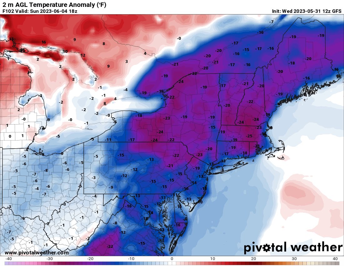
![]() by amugs Wed May 31, 2023 2:55 pm
by amugs Wed May 31, 2023 2:55 pm
44* for my low this morning!!!
Saturday temp change from 90* on Friday is going to be unreal!! Welcome to the Grand Solar Minimum as we get more n more extreme.
Temp Anamoly
Saturday temp change from 90* on Friday is going to be unreal!! Welcome to the Grand Solar Minimum as we get more n more extreme.
Temp Anamoly
_________________
Mugs
AKA:King: Snow Weenie
Self Proclaimed
WINTER 2014-15 : 55.12" +.02 for 6 coatings (avg. 35")
WINTER 2015-16 Total - 29.8" (Avg 35")
WINTER 2016-17 : 39.5" so far

amugs- Advanced Forecaster - Mod
- Posts : 15095
Reputation : 213
Join date : 2013-01-07
Age : 54
Location : Hillsdale,NJ
Page 3 of 3 • 1, 2, 3
Permissions in this forum:
You cannot reply to topics in this forum|
|
|