2023 Atlantic Tropics season
Page 19 of 20 •  1 ... 11 ... 18, 19, 20
 Re: 2023 Atlantic Tropics season
jmanley32 wrote:I know these are not surface winds but they do not depict the size of the wind field? That is what I was showing, if I put the 10m it does not show the wind overland which is annoying but I guess that's how it works.sroc4 wrote:jmanley32 wrote:My god thats gotta be a 500 mile windfield, he literally at least doubles in size, if he had been further west and took a earlier turn would have been Sandy part 2. No it is not going to be Sandy part 2, might be so in Cape cod, RI and eastern CT but not here. Sandy was about a 75mph storm I believe on approach.
compared to currently, this is the HAFS-A, no idea of it's accuracy.
You need to post the surface maps. Not 850mb maps. The his does. It represent what will happen at the surface.
Here is the same time stamp as the one you posted above with the 10m maps winds in MPH. Unfort on Bell these are the only two avail. You can see there are nothing more than gusty winds beyond the eastern end of LI and the immediate coast of NE. Those 850's are deceiving. Maybe you get a gust here there in a heavy rain band translate down to the surface, but overall the 20s- 30's MPH are meh.
sroc4- Admin

- Posts : 8354
Join date : 2013-01-07
weatherwatchermom likes this post
 Re: 2023 Atlantic Tropics season
Last edited by weatherwatchermom on Wed Sep 13, 2023 5:55 pm; edited 1 time in total
weatherwatchermom- Senior Enthusiast

- Posts : 3793
Join date : 2014-11-25
sroc4, Dunnzoo, kalleg and essexcountypete like this post
 Re: 2023 Atlantic Tropics season
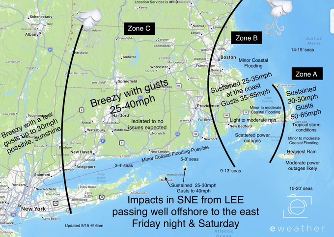
The strongest winds associated with Lee are expected to arrive
Friday night and continue into Saturday, with winds backing NW on
Sat as the hurricane passes well east. The hurricane`s wind field
will be expanding in size as it moves northward, and winds
especially across coastal SE CT and eastern Long Island could become
strong, sustained 25-30 mph with gusts up to 40 mph possible. Can`t
rule out tropical storm force winds in those areas right near the
shoreline in areas with a good NW-N exposure.
NBM still bringing some POPs to portions of eastern Long Island and
CT on the periphery of Lee, with only light rainfall amounts
expected.
_________________
"In weather and in life, there's no winning and losing; there's only winning and learning."
WINTER 2012/2013 TOTALS 43.65"WINTER 2017/2018 TOTALS 62.85" WINTER 2022/2023 TOTALS 4.9"
WINTER 2013/2014 TOTALS 64.85"WINTER 2018/2019 TOTALS 14.25" WINTER 2023/2024 TOTALS 13.1"
WINTER 2014/2015 TOTALS 71.20"WINTER 2019/2020 TOTALS 6.35"
WINTER 2015/2016 TOTALS 35.00"WINTER 2020/2021 TOTALS 37.75"
WINTER 2016/2017 TOTALS 42.25"WINTER 2021/2022 TOTALS 31.65"

sroc4- Admin

- Posts : 8354
Reputation : 302
Join date : 2013-01-07
Location : Wading River, LI
weatherwatchermom likes this post
 Re: 2023 Atlantic Tropics season
sroc4 wrote:jmanley32 wrote:I know these are not surface winds but they do not depict the size of the wind field? That is what I was showing, if I put the 10m it does not show the wind overland which is annoying but I guess that's how it works.sroc4 wrote:jmanley32 wrote:My god thats gotta be a 500 mile windfield, he literally at least doubles in size, if he had been further west and took a earlier turn would have been Sandy part 2. No it is not going to be Sandy part 2, might be so in Cape cod, RI and eastern CT but not here. Sandy was about a 75mph storm I believe on approach.
compared to currently, this is the HAFS-A, no idea of it's accuracy.
You need to post the surface maps. Not 850mb maps. The his does. It represent what will happen at the surface.
Here is the same time stamp as the one you posted above with the 10m maps winds in MPH. Unfort on Bell these are the only two avail. You can see there are nothing more than gusty winds beyond the eastern end of LI and the immediate coast of NE. Those 850's are deceiving. Maybe you get a gust here there in a heavy rain band translate down to the surface, but overall the 20s- 30's MPH are meh.
Yes good news.. we have had higher gusts in a normal storm again the thing that is working is if there is heavy rain in these areas up north that have gotten so much rain already

weatherwatchermom- Senior Enthusiast

- Posts : 3793
Reputation : 78
Join date : 2014-11-25
Location : Hazlet Township, NJ
sroc4 likes this post
 Re: 2023 Atlantic Tropics season

weatherwatchermom- Senior Enthusiast

- Posts : 3793
Reputation : 78
Join date : 2014-11-25
Location : Hazlet Township, NJ
 Re: 2023 Atlantic Tropics season
Cmdr josh rannenberg

weatherwatchermom- Senior Enthusiast

- Posts : 3793
Reputation : 78
Join date : 2014-11-25
Location : Hazlet Township, NJ
 Re: 2023 Atlantic Tropics season
— Ben Noll (@BenNollWeather) September 13, 2023
Hurricane Lee is expected to generate massive waves near the New England coast & Nova Scotia this weekend!
Maximum individual wave heights are predicted to reach upwards of 60-70 feet or as high as a 5-6 story buildingpic.twitter.com/SSFqRudU2r
_________________
Mugs
AKA:King: Snow Weenie
Self Proclaimed
WINTER 2014-15 : 55.12" +.02 for 6 coatings (avg. 35")
WINTER 2015-16 Total - 29.8" (Avg 35")
WINTER 2016-17 : 39.5" so far

amugs- Advanced Forecaster - Mod

- Posts : 15095
Reputation : 213
Join date : 2013-01-07
Age : 54
Location : Hillsdale,NJ
 Re: 2023 Atlantic Tropics season
I remember you guys saying to take 850's subtract like 15-20 mph and those are sustained numbers, and add 15 mph for gusts. I know this was discussed in past I think in the winter, is it different with tropical systems? But yeah looks uneventful unless you on the beach, I don't understand how the beaches of cape see 70+ but if u step back off the beach its 50mph, makes no sense. Thats with the maps you posted and those are gusts.sroc4 wrote:jmanley32 wrote:I know these are not surface winds but they do not depict the size of the wind field? That is what I was showing, if I put the 10m it does not show the wind overland which is annoying but I guess that's how it works.sroc4 wrote:jmanley32 wrote:My god thats gotta be a 500 mile windfield, he literally at least doubles in size, if he had been further west and took a earlier turn would have been Sandy part 2. No it is not going to be Sandy part 2, might be so in Cape cod, RI and eastern CT but not here. Sandy was about a 75mph storm I believe on approach.
compared to currently, this is the HAFS-A, no idea of it's accuracy.
You need to post the surface maps. Not 850mb maps. The his does. It represent what will happen at the surface.
Here is the same time stamp as the one you posted above with the 10m maps winds in MPH. Unfort on Bell these are the only two avail. You can see there are nothing more than gusty winds beyond the eastern end of LI and the immediate coast of NE. Those 850's are deceiving. Maybe you get a gust here there in a heavy rain band translate down to the surface, but overall the 20s- 30's MPH are meh.

jmanley32- Senior Enthusiast

- Posts : 20535
Reputation : 108
Join date : 2013-12-12
Age : 43
Location : Yonkers, NY
 Re: 2023 Atlantic Tropics season
amugs wrote:Wave Heights - Perfect Redux scenerio??— Ben Noll (@BenNollWeather) September 13, 2023
Hurricane Lee is expected to generate massive waves near the New England coast & Nova Scotia this weekend!
Maximum individual wave heights are predicted to reach upwards of 60-70 feet or as high as a 5-6 story buildingpic.twitter.com/SSFqRudU2r
Ok mugs so please educate me....nbc saying long island up to 12 ft NJ shore 6-9 what does this post actually mean and how does that translate for the people along the Mid-Atlantic and ne and Canada I need simplicities

weatherwatchermom- Senior Enthusiast

- Posts : 3793
Reputation : 78
Join date : 2014-11-25
Location : Hazlet Township, NJ
 Re: 2023 Atlantic Tropics season
I think wind field WILL be 600 miles in that report not yet, last I checked it was 240 miles that was earlier today.weatherwatchermom wrote:Hurricane hunters on TV rt now saying wave ht 20-30 ft 100 miles from the eye and tropical storm force winds up to 600 mile span he said it's expanding. Sure hope it breaks down fast as it heads north
Cmdr josh rannenberg
Last edited by jmanley32 on Wed Sep 13, 2023 8:34 pm; edited 1 time in total

jmanley32- Senior Enthusiast

- Posts : 20535
Reputation : 108
Join date : 2013-12-12
Age : 43
Location : Yonkers, NY
 Re: 2023 Atlantic Tropics season
I think I can answer it but mugs can correct me, those waves surges are over the open ocean. He is referring to "the perfect storm" book and movie. The waves were strong on land but in the ocean 100 ft waves according to records of that storm, if you saw the movie a 100 ft wave was what ended in their peril.weatherwatchermom wrote:amugs wrote:Wave Heights - Perfect Redux scenerio??— Ben Noll (@BenNollWeather) September 13, 2023
Hurricane Lee is expected to generate massive waves near the New England coast & Nova Scotia this weekend!
Maximum individual wave heights are predicted to reach upwards of 60-70 feet or as high as a 5-6 story buildingpic.twitter.com/SSFqRudU2r
Ok mugs so please educate me....nbc saying long island up to 12 ft NJ shore 6-9 what does this post actually mean and how does that translate for the people along the Mid-Atlantic and ne and Canada I need simplicities

jmanley32- Senior Enthusiast

- Posts : 20535
Reputation : 108
Join date : 2013-12-12
Age : 43
Location : Yonkers, NY
 Re: 2023 Atlantic Tropics season

dkodgis- Senior Enthusiast

- Posts : 2560
Reputation : 98
Join date : 2013-12-29
 Re: 2023 Atlantic Tropics season
you know they always do that crap for anything. yes here likely just a rainy breezy day unless theres a extreme turn west (which is very unlikely but not impossible). If he made landfall like the JMA over block island that would bring heavy impacts to NYC and jersey. Even where I will be currently it does not look like a big deal and is 120 miles east of NYC (approx).dkodgis wrote:Spectrum tv internet phone etc. sent me an email telling me to prepare for the storm. It is good advice but what will we get here...some wind and some rain?

jmanley32- Senior Enthusiast

- Posts : 20535
Reputation : 108
Join date : 2013-12-12
Age : 43
Location : Yonkers, NY
 Re: 2023 Atlantic Tropics season

jmanley32- Senior Enthusiast

- Posts : 20535
Reputation : 108
Join date : 2013-12-12
Age : 43
Location : Yonkers, NY
 Re: 2023 Atlantic Tropics season
jmanley32 wrote:Nhc really buying the east movement now targeted at nova scotia way far away from bring close to cape. Rb u may be sol on ur location of block island to capecod. May have shift off US completely. I think u still had really good ideas that held merit and who knows maybe he does pull off ur thoughts. But they def arent buy jma or the ai model thats for sure.

_________________
"In weather and in life, there's no winning and losing; there's only winning and learning."
WINTER 2012/2013 TOTALS 43.65"WINTER 2017/2018 TOTALS 62.85" WINTER 2022/2023 TOTALS 4.9"
WINTER 2013/2014 TOTALS 64.85"WINTER 2018/2019 TOTALS 14.25" WINTER 2023/2024 TOTALS 13.1"
WINTER 2014/2015 TOTALS 71.20"WINTER 2019/2020 TOTALS 6.35"
WINTER 2015/2016 TOTALS 35.00"WINTER 2020/2021 TOTALS 37.75"
WINTER 2016/2017 TOTALS 42.25"WINTER 2021/2022 TOTALS 31.65"

sroc4- Admin

- Posts : 8354
Reputation : 302
Join date : 2013-01-07
Location : Wading River, LI
MattyICE likes this post
 Re: 2023 Atlantic Tropics season
Doc safe travels home today!

weatherwatchermom- Senior Enthusiast

- Posts : 3793
Reputation : 78
Join date : 2014-11-25
Location : Hazlet Township, NJ
 Re: 2023 Atlantic Tropics season
TROPICAL STORM FORCE WINDS MOVE INTO NEW ENGLAND FRIDAY
— Mike Masco (@MikeMasco) September 14, 2023
On the present forecast track; Coastal New England will be inside 40+mph winds a solid 24 hours starting 4p Fri. NAM model shows hurricane force gusts hitting #CapeCod by SAT AM with heavy rain bands getting close to… pic.twitter.com/SlE95UGMNr
_________________
Mugs
AKA:King: Snow Weenie
Self Proclaimed
WINTER 2014-15 : 55.12" +.02 for 6 coatings (avg. 35")
WINTER 2015-16 Total - 29.8" (Avg 35")
WINTER 2016-17 : 39.5" so far

amugs- Advanced Forecaster - Mod

- Posts : 15095
Reputation : 213
Join date : 2013-01-07
Age : 54
Location : Hillsdale,NJ
weatherwatchermom likes this post
 Re: 2023 Atlantic Tropics season
With Lee having accelerated faster than most models forecasted a day or two ago, the risk of a more westerly track (i.e center passing within 75 miles of Cape Cod) has dropped to almost none. https://t.co/XWTjZafq5B pic.twitter.com/6iWS3Qs10N
— Yaakov Cantor (@yconsor) September 14, 2023
Climo
_________________
Mugs
AKA:King: Snow Weenie
Self Proclaimed
WINTER 2014-15 : 55.12" +.02 for 6 coatings (avg. 35")
WINTER 2015-16 Total - 29.8" (Avg 35")
WINTER 2016-17 : 39.5" so far

amugs- Advanced Forecaster - Mod

- Posts : 15095
Reputation : 213
Join date : 2013-01-07
Age : 54
Location : Hillsdale,NJ
 Re: 2023 Atlantic Tropics season
jmanley32 wrote:Nhc really buying the east movement now targeted at nova scotia way far away from bring close to cape. Rb u may be sol on ur location of block island to capecod. May have shift off US completely. I think u still had really good ideas that held merit and who knows maybe he does pull off ur thoughts. But they def arent buy jma or the ai model thats for sure.
Thanks for the support, Jon lol I’m officially abandoning my western track idea. Although the pattern generally still supports it, the weaker, and thus, faster moving Lee will have just enough interaction with the lead trough now so that it shouldn’t come back west. Eastern Maine still has to watch, but west of there, no direct landfall is expected. I’m happy to be wrong on this one, though.
If Lee didn’t encounter that dry air earlier on which disrupted the initially strong circulation, I think my ideas would have had a lot more merit. But, unfortunately for me (fortunately for the rest of us), it was never able to recover. And in hindsight, I should have known that it likely wouldn’t, as it’s pretty classic to observe that once those initial circulations are disrupted, the storms very rarely are able to regain their former status and organization. That’s entirely on me, as I took the forecast intensity of Lee for granted. Lesson learned there. That said, the overall evolution of the large-scale pattern played out exactly as I laid out in my original posts, so I can seek some solace in that. But I do sincerely apologize for the overall inaccuracy of the expected outcome and associated concern. No excuse for that, as the error was something that could, and should have been avoided.
rb924119- Meteorologist

- Posts : 6928
Reputation : 194
Join date : 2013-02-06
Age : 32
Location : Greentown, Pa
docstox12, amugs and weatherwatchermom like this post
 Re: 2023 Atlantic Tropics season
you did a great job RB!! always wait for your informed posts!! I for one am happy if it does not work out the way you said!!! as I tell my son..learn and move on..fingers crossed this storm leaves little damage!! and takes no lives!!rb924119 wrote:jmanley32 wrote:Nhc really buying the east movement now targeted at nova scotia way far away from bring close to cape. Rb u may be sol on ur location of block island to capecod. May have shift off US completely. I think u still had really good ideas that held merit and who knows maybe he does pull off ur thoughts. But they def arent buy jma or the ai model thats for sure.
Thanks for the support, Jon lol I’m officially abandoning my western track idea. Although the pattern generally still supports it, the weaker, and thus, faster moving Lee will have just enough interaction with the lead trough now so that it shouldn’t come back west. Eastern Maine still has to watch, but west of there, no direct landfall is expected. I’m happy to be wrong on this one, though.
If Lee didn’t encounter that dry air earlier on which disrupted the initially strong circulation, I think my ideas would have had a lot more merit. But, unfortunately for me (fortunately for the rest of us), it was never able to recover. And in hindsight, I should have known that it likely wouldn’t, as it’s pretty classic to observe that once those initial circulations are disrupted, the storms very rarely are able to regain their former status and organization. That’s entirely on me, as I took the forecast intensity of Lee for granted. Lesson learned there. That said, the overall evolution of the large-scale pattern played out exactly as I laid out in my original posts, so I can seek some solace in that. But I do sincerely apologize for the overall inaccuracy of the expected outcome and associated concern. No excuse for that, as the error was something that could, and should have been avoided.

weatherwatchermom- Senior Enthusiast

- Posts : 3793
Reputation : 78
Join date : 2014-11-25
Location : Hazlet Township, NJ
docstox12 and jmanley32 like this post
 Re: 2023 Atlantic Tropics season
Yo man don't ever put yourself down! You did amazing, there were things that could not be predicted, weather as you know is not a exact science. IMO you got this pretty spot on, a direct bullseye forecast is near impossible with these things, always room to learn more and obviously I am nowhere near your expertise in fact I have little. So smile, get a drink as I will be shortly arrived in CT about 30 min ago, expecting some gusts to 40-50mph possible on Sat but seems most precip will be offshore, but who knows he could pull some last second tricks. And we already nearly have out next one haha! Why do you think I am always asking where you are cuz your good, and though sroc threw a brick at me for this comment and was smashing his head against a board the other day I think his analysis and expertise are good too with a bit of intolerence for me added in (don't get hurt scott, just playing your game : ).rb924119 wrote:jmanley32 wrote:Nhc really buying the east movement now targeted at nova scotia way far away from bring close to cape. Rb u may be sol on ur location of block island to capecod. May have shift off US completely. I think u still had really good ideas that held merit and who knows maybe he does pull off ur thoughts. But they def arent buy jma or the ai model thats for sure.
Thanks for the support, Jon lol I’m officially abandoning my western track idea. Although the pattern generally still supports it, the weaker, and thus, faster moving Lee will have just enough interaction with the lead trough now so that it shouldn’t come back west. Eastern Maine still has to watch, but west of there, no direct landfall is expected. I’m happy to be wrong on this one, though.
If Lee didn’t encounter that dry air earlier on which disrupted the initially strong circulation, I think my ideas would have had a lot more merit. But, unfortunately for me (fortunately for the rest of us), it was never able to recover. And in hindsight, I should have known that it likely wouldn’t, as it’s pretty classic to observe that once those initial circulations are disrupted, the storms very rarely are able to regain their former status and organization. That’s entirely on me, as I took the forecast intensity of Lee for granted. Lesson learned there. That said, the overall evolution of the large-scale pattern played out exactly as I laid out in my original posts, so I can seek some solace in that. But I do sincerely apologize for the overall inaccuracy of the expected outcome and associated concern. No excuse for that, as the error was something that could, and should have been avoided.

jmanley32- Senior Enthusiast

- Posts : 20535
Reputation : 108
Join date : 2013-12-12
Age : 43
Location : Yonkers, NY
kalleg likes this post
 Re: 2023 Atlantic Tropics season
weatherwatchermom wrote:you did a great job RB!! always wait for your informed posts!! I for one am happy if it does not work out the way you said!!! as I tell my son..learn and move on..fingers crossed this storm leaves little damage!! and takes no lives!!rb924119 wrote:jmanley32 wrote:Nhc really buying the east movement now targeted at nova scotia way far away from bring close to cape. Rb u may be sol on ur location of block island to capecod. May have shift off US completely. I think u still had really good ideas that held merit and who knows maybe he does pull off ur thoughts. But they def arent buy jma or the ai model thats for sure.
Thanks for the support, Jon lol I’m officially abandoning my western track idea. Although the pattern generally still supports it, the weaker, and thus, faster moving Lee will have just enough interaction with the lead trough now so that it shouldn’t come back west. Eastern Maine still has to watch, but west of there, no direct landfall is expected. I’m happy to be wrong on this one, though.
If Lee didn’t encounter that dry air earlier on which disrupted the initially strong circulation, I think my ideas would have had a lot more merit. But, unfortunately for me (fortunately for the rest of us), it was never able to recover. And in hindsight, I should have known that it likely wouldn’t, as it’s pretty classic to observe that once those initial circulations are disrupted, the storms very rarely are able to regain their former status and organization. That’s entirely on me, as I took the forecast intensity of Lee for granted. Lesson learned there. That said, the overall evolution of the large-scale pattern played out exactly as I laid out in my original posts, so I can seek some solace in that. But I do sincerely apologize for the overall inaccuracy of the expected outcome and associated concern. No excuse for that, as the error was something that could, and should have been avoided.
You are very good, I learn far more from what you post than the local Mets. Your a mentor to the amateur met community here
phil155- Pro Enthusiast

- Posts : 483
Reputation : 4
Join date : 2019-12-16
 Re: 2023 Atlantic Tropics season
rb924119 wrote:jmanley32 wrote:Nhc really buying the east movement now targeted at nova scotia way far away from bring close to cape. Rb u may be sol on ur location of block island to capecod. May have shift off US completely. I think u still had really good ideas that held merit and who knows maybe he does pull off ur thoughts. But they def arent buy jma or the ai model thats for sure.
Thanks for the support, Jon lol I’m officially abandoning my western track idea. Although the pattern generally still supports it, the weaker, and thus, faster moving Lee will have just enough interaction with the lead trough now so that it shouldn’t come back west. Eastern Maine still has to watch, but west of there, no direct landfall is expected. I’m happy to be wrong on this one, though.
If Lee didn’t encounter that dry air earlier on which disrupted the initially strong circulation, I think my ideas would have had a lot more merit. But, unfortunately for me (fortunately for the rest of us), it was never able to recover. And in hindsight, I should have known that it likely wouldn’t, as it’s pretty classic to observe that once those initial circulations are disrupted, the storms very rarely are able to regain their former status and organization. That’s entirely on me, as I took the forecast intensity of Lee for granted. Lesson learned there. That said, the overall evolution of the large-scale pattern played out exactly as I laid out in my original posts, so I can seek some solace in that. But I do sincerely apologize for the overall inaccuracy of the expected outcome and associated concern. No excuse for that, as the error was something that could, and should have been avoided.
Rb my man you did great and your explanation an dreasomning was spot on. Always learning from a young jedi like yourself. Looking forward to the winter write ups for it is not to far away as the temperatures go into the 50" and possibly 40's tomorrow night for some of our ruburbs peeps!! Great work and analysis. Lee was...Earlee not Latelee as progeed and if he was later well then............
_________________
Mugs
AKA:King: Snow Weenie
Self Proclaimed
WINTER 2014-15 : 55.12" +.02 for 6 coatings (avg. 35")
WINTER 2015-16 Total - 29.8" (Avg 35")
WINTER 2016-17 : 39.5" so far

amugs- Advanced Forecaster - Mod

- Posts : 15095
Reputation : 213
Join date : 2013-01-07
Age : 54
Location : Hillsdale,NJ
 Re: 2023 Atlantic Tropics season
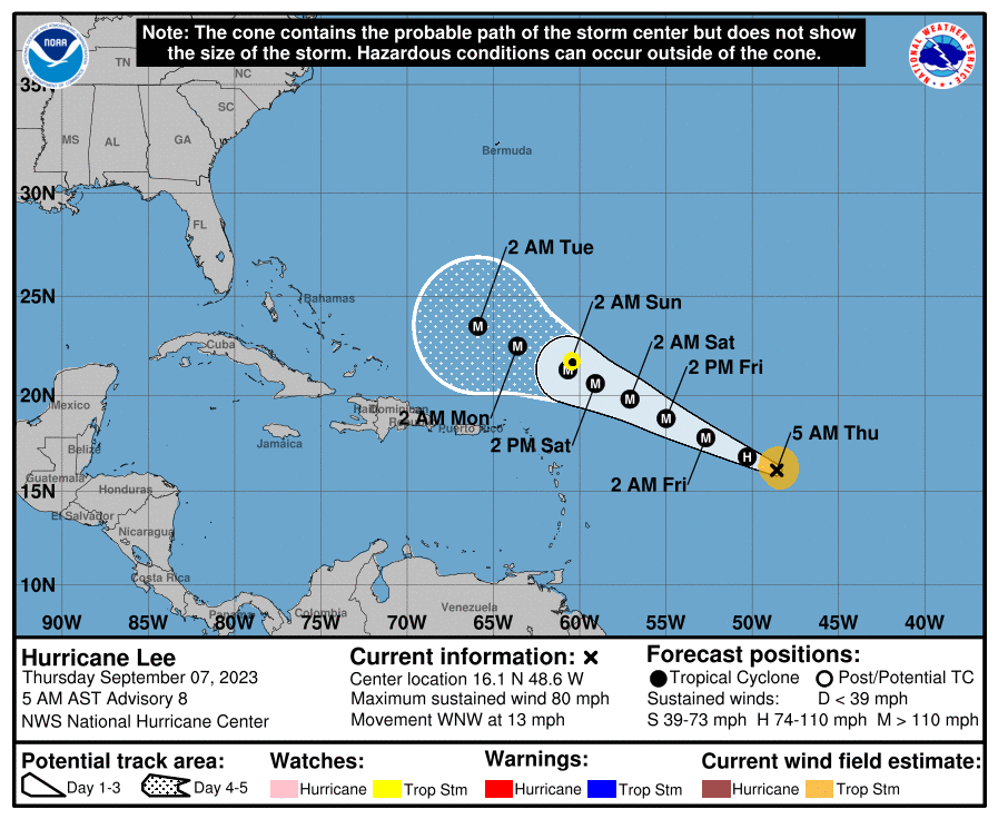
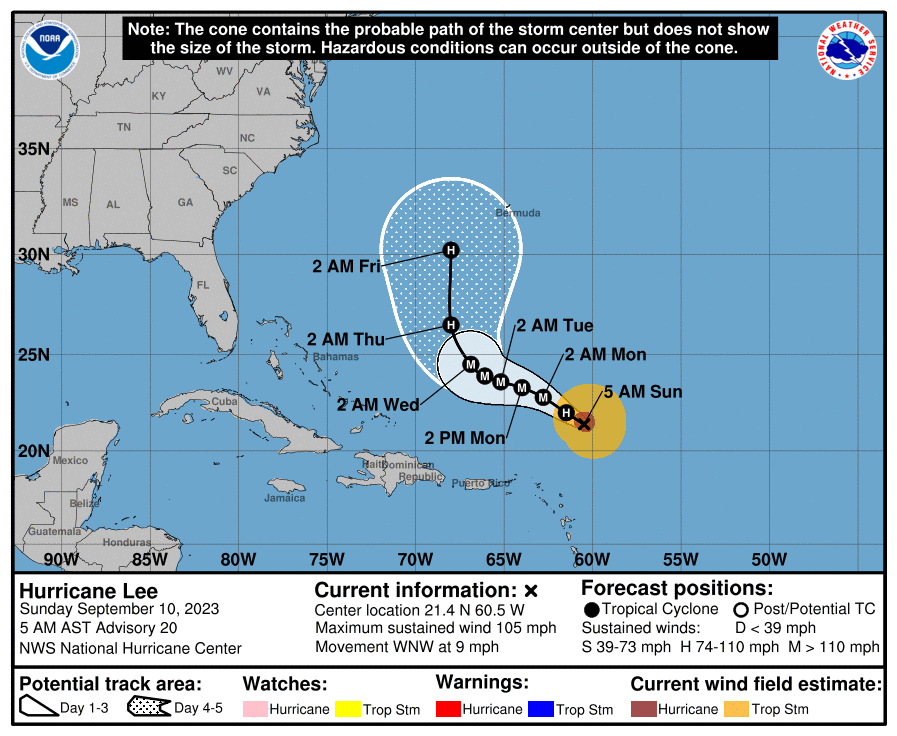
sroc4 wrote:So far between Wed and now Lee's track has rode on the north side of the NHC forecast cone. Third image was the 5am update this am. If we cont to see this trend over the next 2-3days then a miss is the most likely scenario. In my opinion if a direct landfall into NE is going to happen Lee has to start shifting to the south side of that avg track forecast. If it doesn't make it to that 70W line, or at least close, then it's unlikely IMHO that we see a direct landfall west of Maine.
I am taking a direct hit between the Cape and the Delmarva off the table. In fact I'm going to to say anything S of Atlantic City is off my table for a direct landfall. I am going to put a direct US Landfall, Atlantic city through eastern Maine, at a 15-30% chance of happening from west to east respectively. The trend has been for a deeper and stronger trough and a weaker N Atlantic ridge which would increase the likely hood of a recurve. Now keep in mind there is still uncertainty. These are my thoughts as of the current information available; however as we know things are subject to change should the next 2-3days trend differently that the past 2-3 days. The timing of the trough lifting out relative to the system really holds the key. The only way it lifts out before Lee gains too much latitude is if he trends to the south side of the current forecast cone as stated above.
So just a few comments about where Lee is ultimately ending up. This was a post from Sept 10th regarding the trends between Sept 6th-10th. I had pointed out that through the 10th Lee ended up on the N side of the NHC forecast track. In addition to that in the end he also ended up much slower than projected. Back on the 6th(first image) you can see the original forecast was for Lee to be west of the 65W Long line by Monday Sept 11th 2am. However the actual location of Lee by Monday Sept 11th at 5AM(second image) was well east still of that 65w Long line.
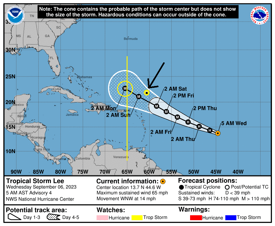
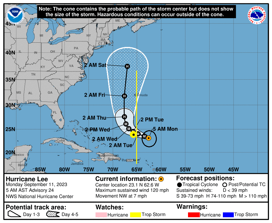
The reason for this, as bolded in the quoted write up above, is that the ridge to Lees north was never that strong. As a result is the westerly steering component was just not that strong. As you can see below(second image) the ridge actual split and there was a competing vector. The Ridge to lees north was weakly steering him WNW, while the ridge to his direct east began to create a steering vector in the complete opposite direction east. This is a main if not THE main reason he slowed down to an almost crawl.
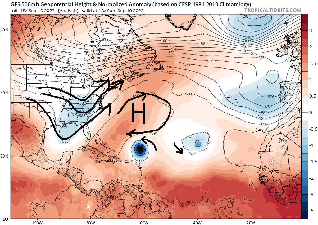
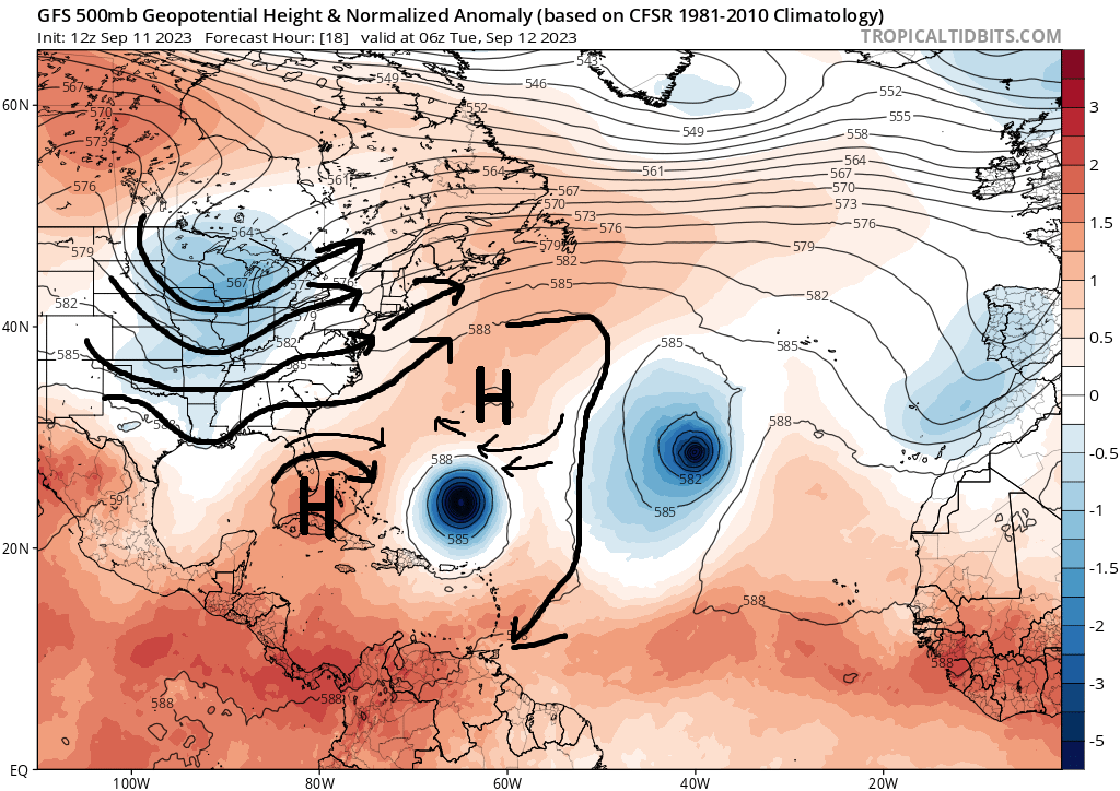
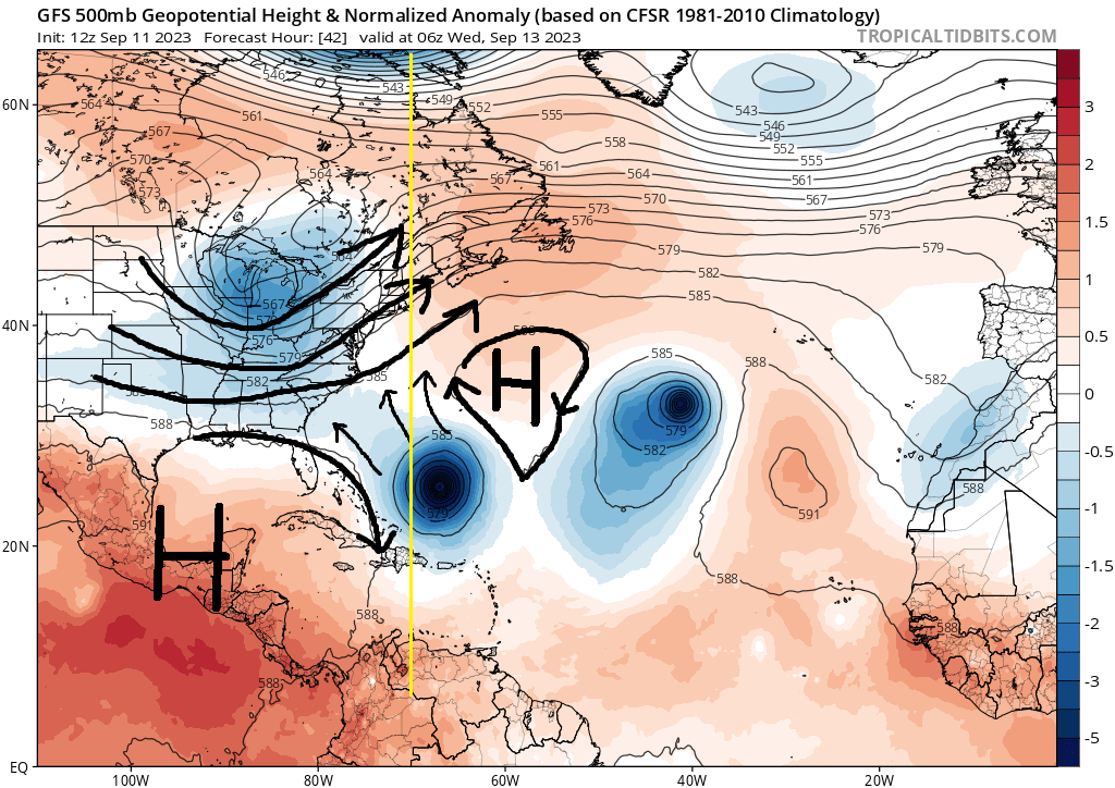
So to conclude my thoughts here, we were saying several days ago that if he slowed down it would give him a higher probability of missing the trough and then get tugged back to the coast by the next trough. The problem is not only did he end up gaining a bit too much latitude because he was on the N side of the forecast cone, by slowing down the westward movement it gave the incoming trough more time to reach the coast such that by the time Lee started interacting with the trough turning him northward the entire Lee Trough interaction took place too far east to ever really give him enough time to cut off from the trough again and get captured by the next one recurving him back NW. He was too far N AND too far E by the time the trough arrived plain and simple.
In the end it was a long fun one to track and Im glad that we dont have to worry too much about Lee. There is still another 24hrs to make sure no funny business but for the most part this one is written.
And Id also like to point out and give some serious Kudos to Ray for seeing this threat and posting this back on Sept 1st a full 16days for landfall. Kudos Ray if you're out there.
Post by rb924119 Fri Sep 01, 2023 3:55 pm
rb924119 wrote:We might have to watch the period from approximately September 9th through the 15th VERY carefully, folks. VERY CAREFULLY. And there are two ways we can get into trouble - either from a long-track system, which I think would be more likely at this time, or, a trough split that festers near the Southeast Coast, feeds back, and then gets drawn along the Eastern Seaboard as an anomalous trough dives in through the Plains.
_________________
"In weather and in life, there's no winning and losing; there's only winning and learning."
WINTER 2012/2013 TOTALS 43.65"WINTER 2017/2018 TOTALS 62.85" WINTER 2022/2023 TOTALS 4.9"
WINTER 2013/2014 TOTALS 64.85"WINTER 2018/2019 TOTALS 14.25" WINTER 2023/2024 TOTALS 13.1"
WINTER 2014/2015 TOTALS 71.20"WINTER 2019/2020 TOTALS 6.35"
WINTER 2015/2016 TOTALS 35.00"WINTER 2020/2021 TOTALS 37.75"
WINTER 2016/2017 TOTALS 42.25"WINTER 2021/2022 TOTALS 31.65"

sroc4- Admin

- Posts : 8354
Reputation : 302
Join date : 2013-01-07
Location : Wading River, LI
amugs and weatherwatchermom like this post
 Re: 2023 Atlantic Tropics season
Frozen.9- Posts : 25
Reputation : 0
Join date : 2021-02-06
sroc4 and amugs like this post
 Re: 2023 Atlantic Tropics season
_________________
Mugs
AKA:King: Snow Weenie
Self Proclaimed
WINTER 2014-15 : 55.12" +.02 for 6 coatings (avg. 35")
WINTER 2015-16 Total - 29.8" (Avg 35")
WINTER 2016-17 : 39.5" so far

amugs- Advanced Forecaster - Mod

- Posts : 15095
Reputation : 213
Join date : 2013-01-07
Age : 54
Location : Hillsdale,NJ
sroc4, kalleg and weatherwatchermom like this post
 Re: 2023 Atlantic Tropics season
I can confirm the gusty winds in eastern, CT already and he is not even at our latitude yet. Thanks for everyones analysis and this on has been a long but fun tracker, looks like the next one is to be with the fishes but we did have some fantasy land runs that hit the area, doubtful.amugs wrote:Breezy to windy condition from the pressure gradiant and Lee's expansive wind field

jmanley32- Senior Enthusiast

- Posts : 20535
Reputation : 108
Join date : 2013-12-12
Age : 43
Location : Yonkers, NY
Page 19 of 20 •  1 ... 11 ... 18, 19, 20
|
|
|

 Home
Home


