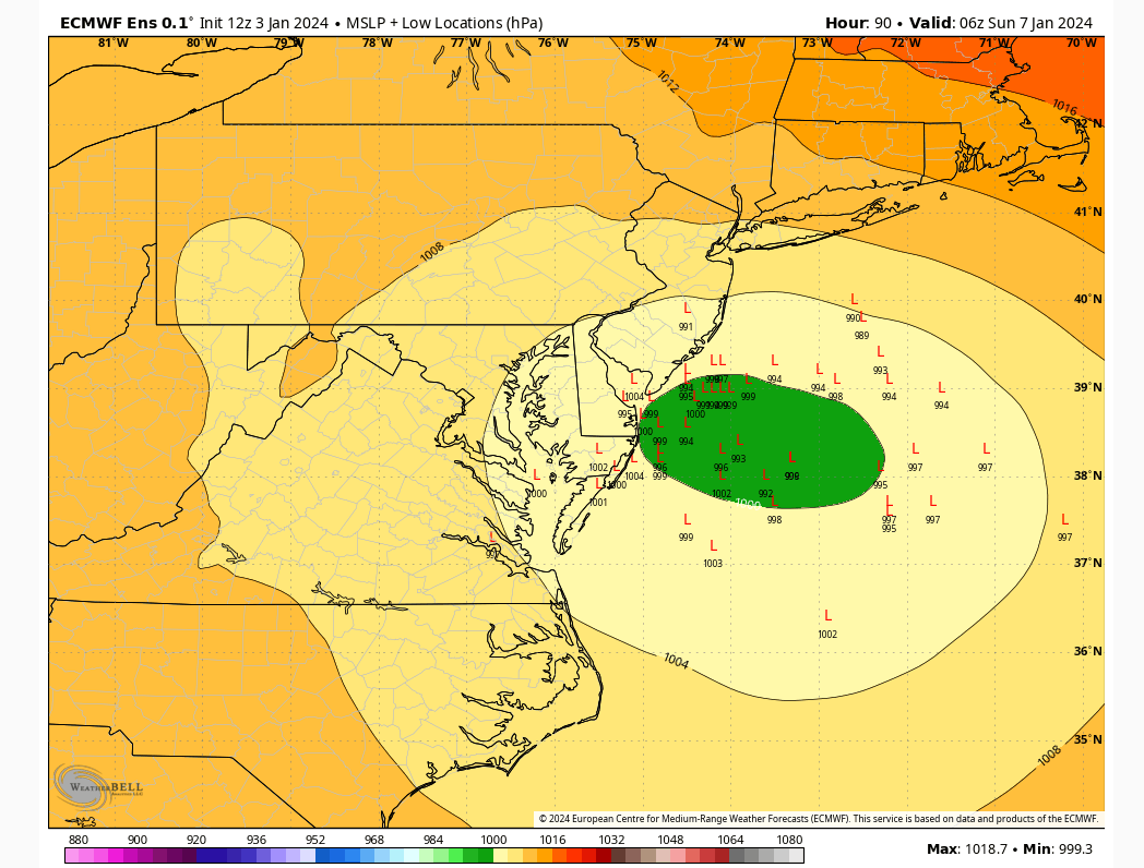
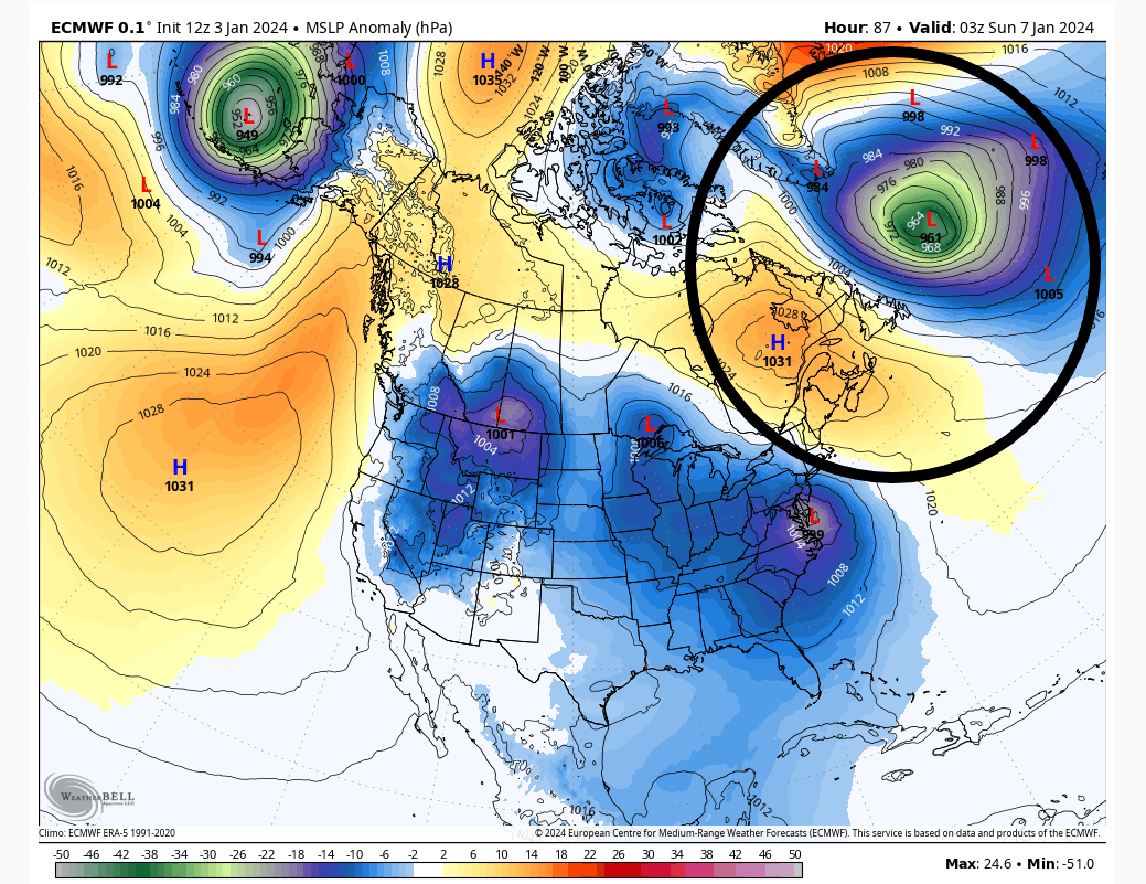
January 2024 Observations and Discussion
+55
mmanisca
Abba701
Aiosamoney21
vascudave
larryrock72
crippo84
Brookster
Fededle22
2004blackwrx
Koroptim
uanswer2me
silentwreck
snowday111
bloc1357
JT33
Angela0621
DAYBLAZER
jurzdevil
DWay
skinsfan1177
Math23x7
hyde345
Irish
richb521
CPcantmeasuresnow
tomsriversnowstorm
SkiSeadooJoe
Grselig
brownie
Snowprincess0204
NJBear
dkodgis
weatherwatchermom
kalleg
frank 638
Frank_Wx
toople
Dunnzoo
Frozen.9
Carvin
MattyICE
SENJsnowman
phil155
dsix85
essexcountypete
docstox12
billg315
jmanley32
nutleyblizzard
aiannone
amugs
rb924119
1190ftalt
sroc4
heehaw453
59 posters
Page 6 of 26
Page 6 of 26 •  1 ... 5, 6, 7 ... 16 ... 26
 Re: January 2024 Observations and Discussion
Definitely better at H5 through 66.
rb924119- Meteorologist

- Posts : 6928
Join date : 2013-02-06
 Re: January 2024 Observations and Discussion
Ok, overall, I liked the presentation of the Euro, and think it’s improved aloft. The reason why the now map doesn’t reflect it is because it tracked the lower-level circulations basically along I-95, which effectively dry slots that area. That’s ok, we can totally work with that track at this lead, as I think it’ll come back southeast a bit in future runs. The key is its appearance aloft looked better, and it was notably better with its jet streak presentation over New England. Very GEM-like.
rb924119- Meteorologist

- Posts : 6928
Join date : 2013-02-06
MattyICE likes this post
 Re: January 2024 Observations and Discussion
rb924119 wrote:Dunnzoo wrote:We also have to adjust those snow totals on the models to account for the heavy, wet snow. It will probably be at 8:1 ratio, don't think we'll see it at 10:1. It's going to be back-breaking for anyone that gets dumped on.
I respectfully disagree, Dunnz. This is actually going to be a pretty high-ratio snow event based on thermals (roughly 20:1 in KNYC), with a strong tendency for dendritic growth.
I'll stick to my wet snow thoughts for now, I can't see it being dry for me in NENJ, as we will be closer to the mix zone. For you in PA, I can see you having a dry powdery snow. I guess we'll see as we get closer where that mix line ends up. Hopefully it stays SE of NYC to give me a chance, hate to have to deal with wet snow. If you have some graphics to share I'd appreciate it.
_________________
Janet
Snowfall winter of 2023-2024 17.5"
Snowfall winter of 2022-2023 6.0"
Snowfall winter of 2021-2022 17.6" 1" sleet 2/25/22
Snowfall winter of 2020-2021 51.1"
Snowfall winter of 2019-2020 8.5"
Snowfall winter of 2018-2019 25.1"
Snowfall winter of 2017-2018 51.9"
Snowfall winter of 2016-2017 45.6"
Snowfall winter of 2015-2016 29.5"
Snowfall winter of 2014-2015 50.55"
Snowfall winter of 2013-2014 66.5"
Dunnzoo- Senior Enthusiast - Mod

- Posts : 4905
Reputation : 68
Join date : 2013-01-11
Age : 62
Location : Westwood, NJ
heehaw453- Advanced Forecaster

- Posts : 3906
Reputation : 86
Join date : 2014-01-20
Location : Bedminster Township, PA Elevation 600' ASL
rb924119 and MattyICE like this post
 Re: January 2024 Observations and Discussion
rb924119 wrote:Ok, overall, I liked the presentation of the Euro, and think it’s improved aloft. The reason why the now map doesn’t reflect it is because it tracked the lower-level circulations basically along I-95, which effectively dry slots that area. That’s ok, we can totally work with that track at this lead, as I think it’ll come back southeast a bit in future runs. The key is its appearance aloft looked better, and it was notably better with its jet streak presentation over New England. Very GEM-like.
I think it's just a little late consolidating this run. Just say a few hours or so IMO. But yes overall the h5 looked good IMO.
heehaw453- Advanced Forecaster

- Posts : 3906
Reputation : 86
Join date : 2014-01-20
Location : Bedminster Township, PA Elevation 600' ASL
 Re: January 2024 Observations and Discussion
Agree, heehaw. The improvements I was looking for, specifically at H5 and H3 were there. That’s what I’m mostly concerned with right now. The northward wobble/slight delay we can work with until Friday nigh, and I think we will end up ok.
rb924119- Meteorologist

- Posts : 6928
Reputation : 194
Join date : 2013-02-06
Age : 32
Location : Greentown, Pa
heehaw453 likes this post
 Re: January 2024 Observations and Discussion
Dunnzoo wrote:rb924119 wrote:Dunnzoo wrote:We also have to adjust those snow totals on the models to account for the heavy, wet snow. It will probably be at 8:1 ratio, don't think we'll see it at 10:1. It's going to be back-breaking for anyone that gets dumped on.
I respectfully disagree, Dunnz. This is actually going to be a pretty high-ratio snow event based on thermals (roughly 20:1 in KNYC), with a strong tendency for dendritic growth.
I'll stick to my wet snow thoughts for now, I can't see it being dry for me in NENJ, as we will be closer to the mix zone. For you in PA, I can see you having a dry powdery snow. I guess we'll see as we get closer where that mix line ends up. Hopefully it stays SE of NYC to give me a chance, hate to have to deal with wet snow. If you have some graphics to share I'd appreciate it.
You’re certainly entitled to do that haha and I can do a more detailed explanation of how I’m getting my numbers tonight once I get out of work haha
rb924119- Meteorologist

- Posts : 6928
Reputation : 194
Join date : 2013-02-06
Age : 32
Location : Greentown, Pa
 Re: January 2024 Observations and Discussion
rb924119 wrote:Ok, overall, I liked the presentation of the Euro, and think it’s improved aloft. The reason why the now map doesn’t reflect it is because it tracked the lower-level circulations basically along I-95, which effectively dry slots that area. That’s ok, we can totally work with that track at this lead, as I think it’ll come back southeast a bit in future runs. The key is its appearance aloft looked better, and it was notably better with its jet streak presentation over New England. Very GEM-like.
And I think you are spot on that jet streak is going to be important. I'd like to see that in southern NJ not SNE.
heehaw453- Advanced Forecaster

- Posts : 3906
Reputation : 86
Join date : 2014-01-20
Location : Bedminster Township, PA Elevation 600' ASL
 Re: January 2024 Observations and Discussion
Rain on the coast is all because I changed the oil in my snowblower this past weekend isnt it?
_________________
-Alex Iannone-

aiannone- Senior Enthusiast - Mod

- Posts : 4815
Reputation : 92
Join date : 2013-01-07
Location : Saint James, LI (Northwest Suffolk Co.)
Dunnzoo, essexcountypete, heehaw453 and billg315 like this post
 Re: January 2024 Observations and Discussion
rb924119 wrote:Agree, heehaw. The improvements I was looking for, specifically at H5 and H3 were there. That’s what I’m mostly concerned with right now. The northward wobble/slight delay we can work with until Friday nigh, and I think we will end up ok.
The other thing I keep neglecting is we are on a waxing phase of a close to 2 sigma -NAO as the storm approaches that's got to account for something in the movement of this unless I just don't I get it...
heehaw453- Advanced Forecaster

- Posts : 3906
Reputation : 86
Join date : 2014-01-20
Location : Bedminster Township, PA Elevation 600' ASL
 Re: January 2024 Observations and Discussion
rb924119 wrote:Dunnzoo wrote:rb924119 wrote:Dunnzoo wrote:We also have to adjust those snow totals on the models to account for the heavy, wet snow. It will probably be at 8:1 ratio, don't think we'll see it at 10:1. It's going to be back-breaking for anyone that gets dumped on.
I respectfully disagree, Dunnz. This is actually going to be a pretty high-ratio snow event based on thermals (roughly 20:1 in KNYC), with a strong tendency for dendritic growth.
I'll stick to my wet snow thoughts for now, I can't see it being dry for me in NENJ, as we will be closer to the mix zone. For you in PA, I can see you having a dry powdery snow. I guess we'll see as we get closer where that mix line ends up. Hopefully it stays SE of NYC to give me a chance, hate to have to deal with wet snow. If you have some graphics to share I'd appreciate it.
You’re certainly entitled to do that haha and I can do a more detailed explanation of how I’m getting my numbers tonight once I get out of work haha
lol I just think based on the soundings, we're just at freezing. I hope you find something different, like I said, I don't like heavy wet snow!
_________________
Janet
Snowfall winter of 2023-2024 17.5"
Snowfall winter of 2022-2023 6.0"
Snowfall winter of 2021-2022 17.6" 1" sleet 2/25/22
Snowfall winter of 2020-2021 51.1"
Snowfall winter of 2019-2020 8.5"
Snowfall winter of 2018-2019 25.1"
Snowfall winter of 2017-2018 51.9"
Snowfall winter of 2016-2017 45.6"
Snowfall winter of 2015-2016 29.5"
Snowfall winter of 2014-2015 50.55"
Snowfall winter of 2013-2014 66.5"

Dunnzoo- Senior Enthusiast - Mod

- Posts : 4905
Reputation : 68
Join date : 2013-01-11
Age : 62
Location : Westwood, NJ
rb924119 likes this post
 Re: January 2024 Observations and Discussion
Nope, and it will be windy per some places I have read, not extreme but even 30 mph trees piled with snow could cause outages.Dunnzoo wrote:rb924119 wrote:Dunnzoo wrote:rb924119 wrote:Dunnzoo wrote:We also have to adjust those snow totals on the models to account for the heavy, wet snow. It will probably be at 8:1 ratio, don't think we'll see it at 10:1. It's going to be back-breaking for anyone that gets dumped on.
I respectfully disagree, Dunnz. This is actually going to be a pretty high-ratio snow event based on thermals (roughly 20:1 in KNYC), with a strong tendency for dendritic growth.
I'll stick to my wet snow thoughts for now, I can't see it being dry for me in NENJ, as we will be closer to the mix zone. For you in PA, I can see you having a dry powdery snow. I guess we'll see as we get closer where that mix line ends up. Hopefully it stays SE of NYC to give me a chance, hate to have to deal with wet snow. If you have some graphics to share I'd appreciate it.
You’re certainly entitled to do that haha and I can do a more detailed explanation of how I’m getting my numbers tonight once I get out of work haha
lol I just think based on the soundings, we're just at freezing. I hope you find something different, like I said, I don't like heavy wet snow!

jmanley32- Senior Enthusiast

- Posts : 20535
Reputation : 108
Join date : 2013-12-12
Age : 43
Location : Yonkers, NY
 Re: January 2024 Observations and Discussion
heehaw453 wrote:rb924119 wrote:Ok, overall, I liked the presentation of the Euro, and think it’s improved aloft. The reason why the now map doesn’t reflect it is because it tracked the lower-level circulations basically along I-95, which effectively dry slots that area. That’s ok, we can totally work with that track at this lead, as I think it’ll come back southeast a bit in future runs. The key is its appearance aloft looked better, and it was notably better with its jet streak presentation over New England. Very GEM-like.
And I think you are spot on that jet streak is going to be important. I'd like to see that in southern NJ not SNE.
Nah, over New England is a good spot. If it was over New Jersey this would be a D.C. special. I think you have it right - it was the later organization in the lower levels combined with the northward wobble. But again, those two things are workable at this stage. The fact that it hung with the GEM and even improved overall aloft is big.
rb924119- Meteorologist

- Posts : 6928
Reputation : 194
Join date : 2013-02-06
Age : 32
Location : Greentown, Pa
heehaw453 likes this post
 Re: January 2024 Observations and Discussion
heehaw453 wrote:rb924119 wrote:Agree, heehaw. The improvements I was looking for, specifically at H5 and H3 were there. That’s what I’m mostly concerned with right now. The northward wobble/slight delay we can work with until Friday nigh, and I think we will end up ok.
The other thing I keep neglecting is we are on a waxing phase of a close to 2 sigma -NAO as the storm approaches that's got to account for something in the movement of this unless I just don't I get it...
I think it does too, but not necessarily in every case. You can have the statistical -NAO with fairly different atmospheric presentations and associated streamflows. In our case, it’s still an east-based block so it has less DIRECT influence. BUT, it is instrumental with pinning/deepening the 50/50 low, which leads to enhanced ridging across southeastern Canada.
Now, as this block matures and continues to retrograde through mid and late month, THEN it will be directly impactful as it will directly be blocking any northward progression of storms into southern Canada.
rb924119- Meteorologist

- Posts : 6928
Reputation : 194
Join date : 2013-02-06
Age : 32
Location : Greentown, Pa
 Re: January 2024 Observations and Discussion
rb924119 wrote:Ok, overall, I liked the presentation of the Euro, and think it’s improved aloft. The reason why the now map doesn’t reflect it is because it tracked the lower-level circulations basically along I-95, which effectively dry slots that area. That’s ok, we can totally work with that track at this lead, as I think it’ll come back southeast a bit in future runs. The key is its appearance aloft looked better, and it was notably better with its jet streak presentation over New England. Very GEM-like.
I hope you’re right but weather is weather. 12z Euro looks like a wash out for NYC at least how I see it.
toople- Posts : 67
Reputation : 0
Join date : 2015-01-01
Location : Nutley, NJ
 Re: January 2024 Observations and Discussion
Really? Rb do you have euro snow map?toople wrote:rb924119 wrote:Ok, overall, I liked the presentation of the Euro, and think it’s improved aloft. The reason why the now map doesn’t reflect it is because it tracked the lower-level circulations basically along I-95, which effectively dry slots that area. That’s ok, we can totally work with that track at this lead, as I think it’ll come back southeast a bit in future runs. The key is its appearance aloft looked better, and it was notably better with its jet streak presentation over New England. Very GEM-like.
I hope you’re right but weather is weather. 12z Euro looks like a wash out for NYC at least how I see it.

jmanley32- Senior Enthusiast

- Posts : 20535
Reputation : 108
Join date : 2013-12-12
Age : 43
Location : Yonkers, NY
 Re: January 2024 Observations and Discussion
toople wrote:rb924119 wrote:Ok, overall, I liked the presentation of the Euro, and think it’s improved aloft. The reason why the now map doesn’t reflect it is because it tracked the lower-level circulations basically along I-95, which effectively dry slots that area. That’s ok, we can totally work with that track at this lead, as I think it’ll come back southeast a bit in future runs. The key is its appearance aloft looked better, and it was notably better with its jet streak presentation over New England. Very GEM-like.
I hope you’re right but weather is weather. 12z Euro looks like a wash out for NYC at least how I see it.
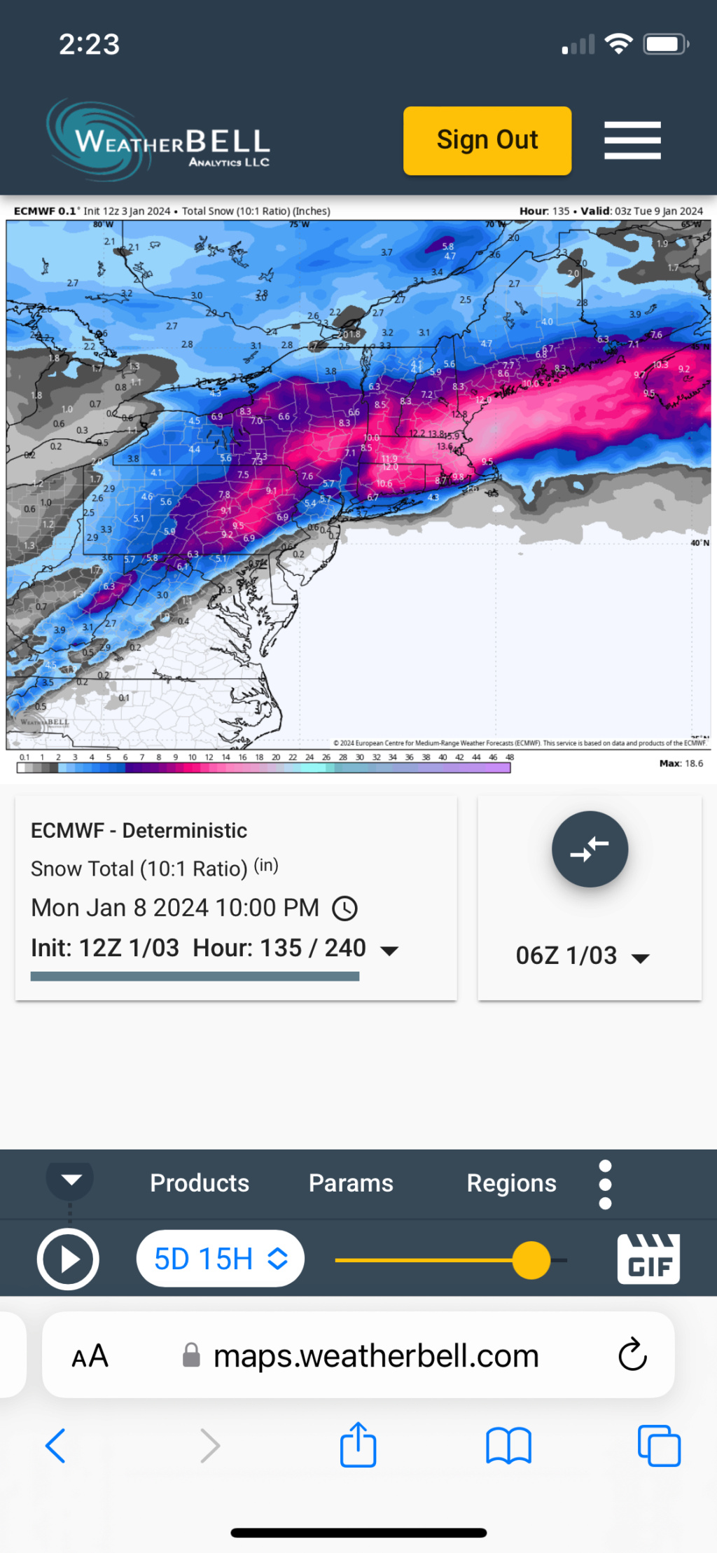
You’re not wrong, but be patient. We are four days away, plenty of time to shift the 50 miles you needed in that run verbatim
And, the 12z Ensemble brings NYC 6”, and are notably snowier than past runs.
rb924119- Meteorologist

- Posts : 6928
Reputation : 194
Join date : 2013-02-06
Age : 32
Location : Greentown, Pa
 Re: January 2024 Observations and Discussion
jmanley32 wrote:Really? Rb do you have euro snow map?toople wrote:rb924119 wrote:Ok, overall, I liked the presentation of the Euro, and think it’s improved aloft. The reason why the now map doesn’t reflect it is because it tracked the lower-level circulations basically along I-95, which effectively dry slots that area. That’s ok, we can totally work with that track at this lead, as I think it’ll come back southeast a bit in future runs. The key is its appearance aloft looked better, and it was notably better with its jet streak presentation over New England. Very GEM-like.
I hope you’re right but weather is weather. 12z Euro looks like a wash out for NYC at least how I see it.

rb924119- Meteorologist

- Posts : 6928
Reputation : 194
Join date : 2013-02-06
Age : 32
Location : Greentown, Pa
jmanley32 likes this post
heehaw453- Advanced Forecaster

- Posts : 3906
Reputation : 86
Join date : 2014-01-20
Location : Bedminster Township, PA Elevation 600' ASL
rb924119 and jmanley32 like this post
 Re: January 2024 Observations and Discussion
Upton now showing this an all rain event at 34* for LI
_________________
-Alex Iannone-

aiannone- Senior Enthusiast - Mod

- Posts : 4815
Reputation : 92
Join date : 2013-01-07
Location : Saint James, LI (Northwest Suffolk Co.)
 Re: January 2024 Observations and Discussion
We need a thumbs down option...I wouldn't put too much stock in it as you know.aiannone wrote:Upton now showing this an all rain event at 34* for LI

jmanley32- Senior Enthusiast

- Posts : 20535
Reputation : 108
Join date : 2013-12-12
Age : 43
Location : Yonkers, NY
heehaw453- Advanced Forecaster

- Posts : 3906
Reputation : 86
Join date : 2014-01-20
Location : Bedminster Township, PA Elevation 600' ASL
rb924119 likes this post

aiannone- Senior Enthusiast - Mod

- Posts : 4815
Reputation : 92
Join date : 2013-01-07
Location : Saint James, LI (Northwest Suffolk Co.)
 Re: January 2024 Observations and Discussion
SREFs MUCH MORE ENTHUSED than the NAM. This makes me think the NAM is out to lunch with the GFS right now.
rb924119- Meteorologist

- Posts : 6928
Reputation : 194
Join date : 2013-02-06
Age : 32
Location : Greentown, Pa
 Re: January 2024 Observations and Discussion
NWS update:
Hazardous Weather Outlook
National Weather Service New York NY
332 PM EST Wed Jan 3 2024
CTZ005-006-NJZ002-004-103-104-NYZ067>070-042045-
Northern Fairfield-Northern New Haven-Western Passaic-
Eastern Passaic-Western Bergen-Eastern Bergen-Orange-Putnam-Rockland-
Northern Westchester-
332 PM EST Wed Jan 3 2024
This Hazardous Weather Outlook is for southern Connecticut,
northeast New Jersey and southeast New York.
.DAY ONE...Tonight.
Hazardous weather is not expected at this time.
.DAYS TWO THROUGH SEVEN...Thursday through Tuesday.
An offshore low is expected to produce snow, possibly mixed with rain
at times, Saturday night into Sunday. The potential exists for 4 to 8
inches of snow.
_________________
Janet
Snowfall winter of 2023-2024 17.5"
Snowfall winter of 2022-2023 6.0"
Snowfall winter of 2021-2022 17.6" 1" sleet 2/25/22
Snowfall winter of 2020-2021 51.1"
Snowfall winter of 2019-2020 8.5"
Snowfall winter of 2018-2019 25.1"
Snowfall winter of 2017-2018 51.9"
Snowfall winter of 2016-2017 45.6"
Snowfall winter of 2015-2016 29.5"
Snowfall winter of 2014-2015 50.55"
Snowfall winter of 2013-2014 66.5"

Dunnzoo- Senior Enthusiast - Mod

- Posts : 4905
Reputation : 68
Join date : 2013-01-11
Age : 62
Location : Westwood, NJ
 Re: January 2024 Observations and Discussion
Upton's latest disco
.LONG TERM /FRIDAY NIGHT THROUGH WEDNESDAY/...
No major changes with the 12Z model cycle with the general idea of
the low for this weekend. There remain some differences wrt the
exact track however. The ECMWF is the furthest N, and looks like an
outlier when compared to the GFS and GEM, which are further S. The
GFS Ensemble mean is even further S, so the fcst has been tweaked
towards a more sly, colder soln.
The models are often too warm with sfc temps this far out,
particularly on the cold side of the sys. Couple this with a spread
in tracks, and the NBM looks too warm attm. The end result could be
warmer if the track ends up farther N, but based on the GFS ensemble
and the low not getting to 40N, blended the NBM10 percent with the
CONSALL for sfc temps late Sat thru Sun.
Based on the expected nely winds, a coastal front would likely
develop across sern LI and possibly into sern CT, adding another
layer to the temp complexity. This boundary should delineate a
mainly all rain event from snow or a mixed event.
The low is progged to get around 999 by 12Z Sun per the GFS, but
there is some model spread in the intensity as well. The GEM appears
to be the deepest, getting down to around 988. This signals that a
big wind event is not expected attm. The deepest low soln would
likely yield peak gusts around 40kt for sern areas.
For snowfall, in general this looks like a 4-8 inch with locally
higher amounts sys where it remains all snow N and W of NYC, 3-6
most of the area, and 2-4 or less much of LI and the ern CT coast.
Again this is all subject to change, with a track to the N bringing
more rain and a track further S beginning to limit pcpn amounts.
Will add a mention in the HWO for the 4-8 inch zone.
_________________
-Alex Iannone-

aiannone- Senior Enthusiast - Mod

- Posts : 4815
Reputation : 92
Join date : 2013-01-07
Location : Saint James, LI (Northwest Suffolk Co.)
 Re: January 2024 Observations and Discussion
Of course southern WC is left out, wont take much to add us though and the discussion mentions 3-6 which I would be more than willing to take as opposed to nada.Dunnzoo wrote:NWS update:
Hazardous Weather Outlook
National Weather Service New York NY
332 PM EST Wed Jan 3 2024
CTZ005-006-NJZ002-004-103-104-NYZ067>070-042045-
Northern Fairfield-Northern New Haven-Western Passaic-
Eastern Passaic-Western Bergen-Eastern Bergen-Orange-Putnam-Rockland-
Northern Westchester-
332 PM EST Wed Jan 3 2024
This Hazardous Weather Outlook is for southern Connecticut,
northeast New Jersey and southeast New York.
.DAY ONE...Tonight.
Hazardous weather is not expected at this time.
.DAYS TWO THROUGH SEVEN...Thursday through Tuesday.
An offshore low is expected to produce snow, possibly mixed with rain
at times, Saturday night into Sunday. The potential exists for 4 to 8
inches of snow.

jmanley32- Senior Enthusiast

- Posts : 20535
Reputation : 108
Join date : 2013-12-12
Age : 43
Location : Yonkers, NY
Page 6 of 26 •  1 ... 5, 6, 7 ... 16 ... 26
Page 6 of 26
Permissions in this forum:
You cannot reply to topics in this forum|
|
|

 Home
Home
