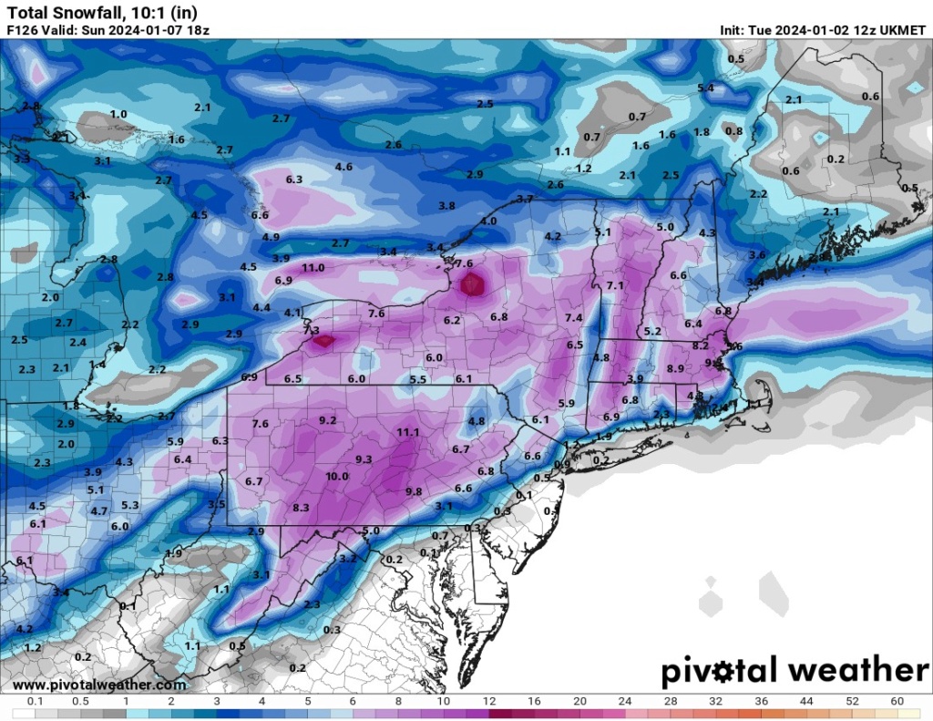
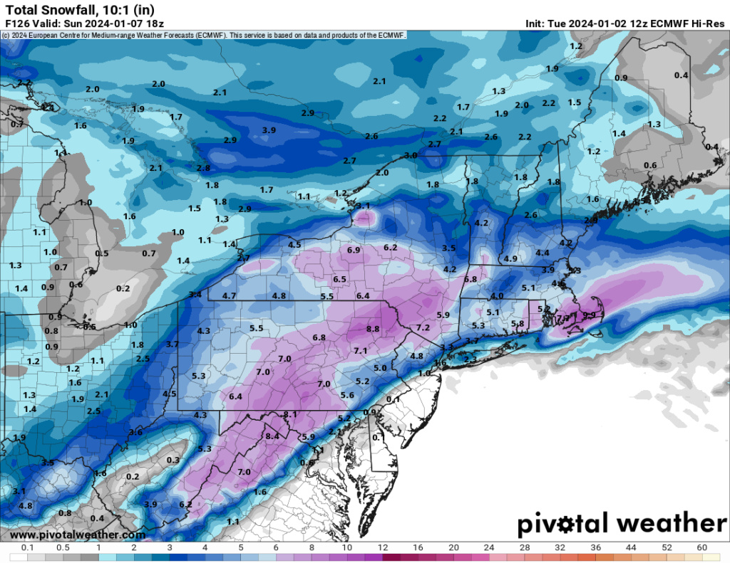
January 2024 Observations and Discussion
+55
mmanisca
Abba701
Aiosamoney21
vascudave
larryrock72
crippo84
Brookster
Fededle22
2004blackwrx
Koroptim
uanswer2me
silentwreck
snowday111
bloc1357
JT33
Angela0621
DAYBLAZER
jurzdevil
DWay
skinsfan1177
Math23x7
hyde345
Irish
richb521
CPcantmeasuresnow
tomsriversnowstorm
SkiSeadooJoe
Grselig
brownie
Snowprincess0204
NJBear
dkodgis
weatherwatchermom
kalleg
frank 638
Frank_Wx
toople
Dunnzoo
Frozen.9
Carvin
MattyICE
SENJsnowman
phil155
dsix85
essexcountypete
docstox12
billg315
jmanley32
nutleyblizzard
aiannone
amugs
rb924119
1190ftalt
sroc4
heehaw453
59 posters
Page 2 of 26
Page 2 of 26 •  1, 2, 3 ... 14 ... 26
 Re: January 2024 Observations and Discussion
rb924119 wrote:heehaw453 wrote:I am going to reiterate and this IMO of course in order for this to work out well on the I95 and even n/w a bit from there this n/s has to drop lower and interact with the s/s. Why? It's not only igniting the storm to get the best dynamics, it's providing and reinforcing cold air. If this stays separate this IMO won't work out well for I95 and possibly a bit n/w of there.
The way this is modelled is a SNE/CNE big event.
Overall I agree with you. I don’t think this depiction is accurate, though. I was looking this morning, and you’re advecting what’s now approximately 1.5-sigma PWAT (was previously approximately 1-sigma, so here comes our expected moisture increase) into this thing. Now you force that to rise……does it really make sense that you won’t induce an anomalous jet to the north/northeast in response to the diabatic heat release from condensing all that water vapor? Sorry, I don’t buy it, and I think we see that northern jet start appearing on future runs. The GEM looks a lot better to me.
I agree with you Rb. I think they're going to waffle a bit on that especially at this range. But that IMO is the wild card with this thing. If we get that set this has very high potential. Like what Frank calls Godzilla.
heehaw453- Advanced Forecaster

- Posts : 3906
Join date : 2014-01-20
rb924119 likes this post
 Re: January 2024 Observations and Discussion
And Rb you are right I just looked at the GEM and it's improved.
heehaw453- Advanced Forecaster

- Posts : 3906
Join date : 2014-01-20
docstox12 and rb924119 like this post
 Re: January 2024 Observations and Discussion
Oo yeah, I think that will get realized regardless as the ratios should be really good with this storm too, as will dendritic growth.
rb924119- Meteorologist

- Posts : 6931
Reputation : 194
Join date : 2013-02-06
Age : 32
Location : Greentown, Pa
heehaw453 likes this post
 Re: January 2024 Observations and Discussion
GFS has waffled so much it's hard to really analyze its runs. GEFS have been steadfast overall.
12Z ICON nukes the region as does CMC
Euro up next so we'll see what it has to say.
0Z tonight should have give better guidance since the systems are near the shores
12Z ICON nukes the region as does CMC
Euro up next so we'll see what it has to say.
0Z tonight should have give better guidance since the systems are near the shores
_________________
Mugs
AKA:King: Snow Weenie
Self Proclaimed
WINTER 2014-15 : 55.12" +.02 for 6 coatings (avg. 35")
WINTER 2015-16 Total - 29.8" (Avg 35")
WINTER 2016-17 : 39.5" so far

amugs- Advanced Forecaster - Mod

- Posts : 15095
Reputation : 213
Join date : 2013-01-07
Age : 54
Location : Hillsdale,NJ

aiannone- Senior Enthusiast - Mod

- Posts : 4815
Reputation : 92
Join date : 2013-01-07
Location : Saint James, LI (Northwest Suffolk Co.)
 Re: January 2024 Observations and Discussion
Thats GFS and Ukie now that have the coast toast, I was afraid this could be a solution. Keeping all hope tempered now, I know its model waffling but its obviously a possible outcome. Also another thing I thought of and this goes for everyone how is this going to stick? I think a lot would be lost to saturated warm ground. I know if it snows hard enough it could but its going to be a wet compacted snow no? To get a foot I think would be difficult?

jmanley32- Senior Enthusiast

- Posts : 20535
Reputation : 108
Join date : 2013-12-12
Age : 43
Location : Yonkers, NY
 Re: January 2024 Observations and Discussion
To clarify I mean I am tempering hope for myself, because that's the only way I will be able to cope if I see rain and no significant snow, I don't want a measly few inches they can keep that. lol

jmanley32- Senior Enthusiast

- Posts : 20535
Reputation : 108
Join date : 2013-12-12
Age : 43
Location : Yonkers, NY
 Re: January 2024 Observations and Discussion
jmanley32 wrote:To clarify I mean I am tempering hope for myself, because that's the only way I will be able to cope if I see rain and no significant snow, I don't want a measly few inches they can keep that. lol
Just a couple quick thoughts JMan. One your approach of tempering expectations is sound. If we get a Godzilla you'll be thrilled and if we get rain you won't have to be unduly disappointed. lol.
But more specifically, I would not, 4-5 days out, read too much into ANY model verbatim good or bad. We all know these models will waffle and trend back and forth 3, 4, 5 days in advance. Even 24 hours in advance sometimes. So, a lot of scenarios are all still on the table from too far NW, to jackpot for us all, to suppressed SE. Have to let the next few days play out until the models get enough data input from real-time conditions to give us a more accurate output.
Finally, as to stickage, that shouldn't be an issue here. 1. If we're getting snow here, it likely will be because enough cold air is present to keep temps near or just below freezing; 2. There are no sun angle issues on Jan. 6; 3. Currently modeled this storm is mostly at night anyway so no sun issues of any sort; and 4. The rates with this -- if it is heavy snow -- should be more than dynamic enough to overcome any semi-warm surface. At least away from the immediate coastline.

billg315- Advanced Forecaster - Mod

- Posts : 4483
Reputation : 185
Join date : 2015-01-24
Age : 50
Location : Flemington, NJ
amugs likes this post
 Re: January 2024 Observations and Discussion
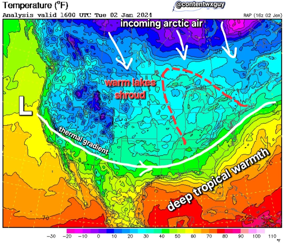
Again this is what the storm should eventuall take as far as track is concerned - maybe a wiggle (20 miles) N or S of it but close to it.

_________________
Mugs
AKA:King: Snow Weenie
Self Proclaimed
WINTER 2014-15 : 55.12" +.02 for 6 coatings (avg. 35")
WINTER 2015-16 Total - 29.8" (Avg 35")
WINTER 2016-17 : 39.5" so far

amugs- Advanced Forecaster - Mod

- Posts : 15095
Reputation : 213
Join date : 2013-01-07
Age : 54
Location : Hillsdale,NJ

aiannone- Senior Enthusiast - Mod

- Posts : 4815
Reputation : 92
Join date : 2013-01-07
Location : Saint James, LI (Northwest Suffolk Co.)
amugs likes this post
 Re: January 2024 Observations and Discussion
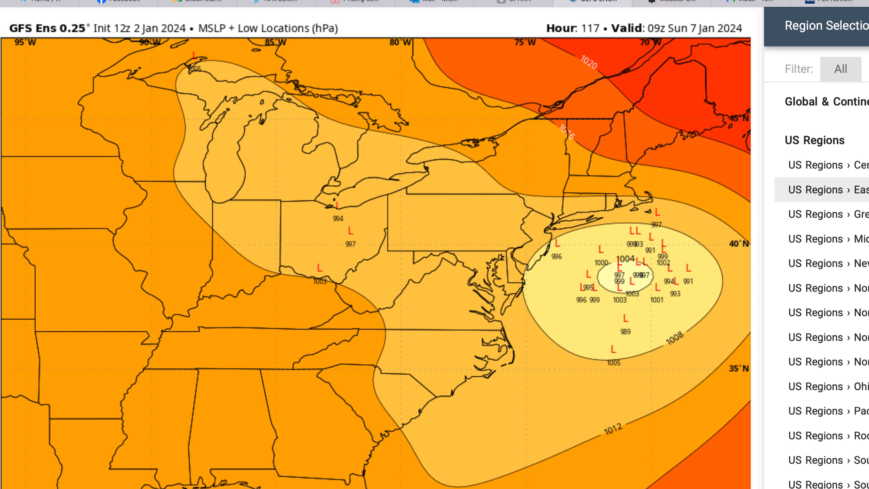
Just for good measure look at your GEFS ENS mean. Much more SE than your Operational that Rb loves NOT to look at LOL!! Don't blame him waffles like a flap jack on a griddle in a diner!

_________________
Mugs
AKA:King: Snow Weenie
Self Proclaimed
WINTER 2014-15 : 55.12" +.02 for 6 coatings (avg. 35")
WINTER 2015-16 Total - 29.8" (Avg 35")
WINTER 2016-17 : 39.5" so far

amugs- Advanced Forecaster - Mod

- Posts : 15095
Reputation : 213
Join date : 2013-01-07
Age : 54
Location : Hillsdale,NJ
SENJsnowman likes this post
 Re: January 2024 Observations and Discussion
All the models today 12Z are showing very little if any n/s interaction. Of course tomorrow is another story but you'd want to see that trend stop and reverse course tomorrow. This won't be be a Godzilla for anyone IMO unless we get that phasing at the right time. Can still be a nice event for NW I95 though. Hell I'd take 3-6" right now sign on the dotted line.
heehaw453- Advanced Forecaster

- Posts : 3906
Reputation : 86
Join date : 2014-01-20
Location : Bedminster Township, PA Elevation 600' ASL
 Re: January 2024 Observations and Discussion
Exactly the track I posted in the map from content wx guy.
It sheared it out more and has it weaker but hey we'll take it at this stage and more runs to go.
How many times have we seen these storms fade a bit in this time frame to come back stronger? Many, glass half full here folks - positivity is a key to life! With a STJ fetch and latent heat release as we see in the SE it bodes well for a stronger storm IMO on this run. Move onto 18Z but more so 0Z runs overall IMO.
_________________
Mugs
AKA:King: Snow Weenie
Self Proclaimed
WINTER 2014-15 : 55.12" +.02 for 6 coatings (avg. 35")
WINTER 2015-16 Total - 29.8" (Avg 35")
WINTER 2016-17 : 39.5" so far

amugs- Advanced Forecaster - Mod

- Posts : 15095
Reputation : 213
Join date : 2013-01-07
Age : 54
Location : Hillsdale,NJ
 Re: January 2024 Observations and Discussion
heehaw453 wrote:All the models today 12Z are showing very little if any n/s interaction. Of course tomorrow is another story but you'd want to see that trend stop and reverse course tomorrow. This won't be be a Godzilla for anyone IMO unless we get that phasing at the right time. Can still be a nice event for NW I95 though. Hell I'd take 3-6" right now sign on the dotted line.
36 degrees, partly cloudy, calm wind.
I agree, I am fine with a 3 to 6 just to break the snowless streak.It has been like a 300 hitter in an 0 for 25 hitting slump.ANY snowstorm is welcome to break the jinx.
As Mugs says, glass half full always, this thing has the potential to be a good one.,
Last edited by docstox12 on Tue Jan 02, 2024 2:10 pm; edited 1 time in total

docstox12- Wx Statistician Guru

- Posts : 8530
Reputation : 222
Join date : 2013-01-07
Age : 73
Location : Monroe NY
heehaw453 likes this post
 Re: January 2024 Observations and Discussion
Bernie Rayno two hours ago..."this storm track is perfect for New York City"
https://www.youtube.com/watch?v=D4jFHdVh9ZQ
https://www.youtube.com/watch?v=D4jFHdVh9ZQ

essexcountypete- Pro Enthusiast

- Posts : 783
Reputation : 12
Join date : 2013-12-09
Location : Bloomfield, NJ
 Re: January 2024 Observations and Discussion
heehaw453 wrote:All the models today 12Z are showing very little if any n/s interaction. Of course tomorrow is another story but you'd want to see that trend stop and reverse course tomorrow. This won't be be a Godzilla for anyone IMO unless we get that phasing at the right time. Can still be a nice event for NW I95 though. Hell I'd take 3-6" right now sign on the dotted line.
I dont think this is an interaction with the n/s issue. This is a southern system that comes into a cold antecedent air mass. Question is how consolidated is the enrgy at our latitude. Biggest solns showed a closed low and strong vort. Latest trends on euro have been to not have as consolidated energy. That's a problem.
12z yesterday 00z then 12z today


_________________
"In weather and in life, there's no winning and losing; there's only winning and learning."
WINTER 2012/2013 TOTALS 43.65"WINTER 2017/2018 TOTALS 62.85" WINTER 2022/2023 TOTALS 4.9"
WINTER 2013/2014 TOTALS 64.85"WINTER 2018/2019 TOTALS 14.25" WINTER 2023/2024 TOTALS 13.1"
WINTER 2014/2015 TOTALS 71.20"WINTER 2019/2020 TOTALS 6.35"
WINTER 2015/2016 TOTALS 35.00"WINTER 2020/2021 TOTALS 37.75"
WINTER 2016/2017 TOTALS 42.25"WINTER 2021/2022 TOTALS 31.65"

sroc4- Admin

- Posts : 8354
Reputation : 302
Join date : 2013-01-07
Location : Wading River, LI
 Re: January 2024 Observations and Discussion

_________________
"In weather and in life, there's no winning and losing; there's only winning and learning."
WINTER 2012/2013 TOTALS 43.65"WINTER 2017/2018 TOTALS 62.85" WINTER 2022/2023 TOTALS 4.9"
WINTER 2013/2014 TOTALS 64.85"WINTER 2018/2019 TOTALS 14.25" WINTER 2023/2024 TOTALS 13.1"
WINTER 2014/2015 TOTALS 71.20"WINTER 2019/2020 TOTALS 6.35"
WINTER 2015/2016 TOTALS 35.00"WINTER 2020/2021 TOTALS 37.75"
WINTER 2016/2017 TOTALS 42.25"WINTER 2021/2022 TOTALS 31.65"

sroc4- Admin

- Posts : 8354
Reputation : 302
Join date : 2013-01-07
Location : Wading River, LI
 Re: January 2024 Observations and Discussion
Bernie said the only wrinkle is if the system maintains its energy as it gets towards the coast. The Canadian shows it getting a bit strung out. He made it a point that there’s a fresh injection of cold air so most of NYC Metro could be in store for a 3-6+ event. He conveniently left out Long Island! But did mention it’s an ideal track for NYC.
dsix85- Pro Enthusiast

- Posts : 349
Reputation : 8
Join date : 2014-01-01
Location : New York
phil155 likes this post
 Re: January 2024 Observations and Discussion
dsix85 wrote:Bernie said the only wrinkle is if the system maintains its energy as it gets towards the coast. The Canadian shows it getting a bit strung out. He made it a point that there’s a fresh injection of cold air so most of NYC Metro could be in store for a 3-6+ event. He conveniently left out Long Island! But did mention it’s an ideal track for NYC.
Just watched his video. He actually does point out Long Island. Right at the 4:30mark. He also mentions pretty much what I just pointed out about the euro trends spreading out the energy. Again this energy begins to come ashore late tonight and early tomorrow and is completely over the SW conus by late tomorrow and tomorrow eve. What I’m not quite clear on is why the trailing energy weakens this energy. That’s I’m a little confused in and he doesn’t explain it in the video.
_________________
"In weather and in life, there's no winning and losing; there's only winning and learning."
WINTER 2012/2013 TOTALS 43.65"WINTER 2017/2018 TOTALS 62.85" WINTER 2022/2023 TOTALS 4.9"
WINTER 2013/2014 TOTALS 64.85"WINTER 2018/2019 TOTALS 14.25" WINTER 2023/2024 TOTALS 13.1"
WINTER 2014/2015 TOTALS 71.20"WINTER 2019/2020 TOTALS 6.35"
WINTER 2015/2016 TOTALS 35.00"WINTER 2020/2021 TOTALS 37.75"
WINTER 2016/2017 TOTALS 42.25"WINTER 2021/2022 TOTALS 31.65"

sroc4- Admin

- Posts : 8354
Reputation : 302
Join date : 2013-01-07
Location : Wading River, LI
essexcountypete likes this post
 Re: January 2024 Observations and Discussion
sroc4 wrote:heehaw453 wrote:All the models today 12Z are showing very little if any n/s interaction. Of course tomorrow is another story but you'd want to see that trend stop and reverse course tomorrow. This won't be be a Godzilla for anyone IMO unless we get that phasing at the right time. Can still be a nice event for NW I95 though. Hell I'd take 3-6" right now sign on the dotted line.
I dont think this is an interaction with the n/s issue. This is a southern system that comes into a cold antecedent air mass. Question is how consolidated is the enrgy at our latitude. Biggest solns showed a closed low and strong vort. Latest trends on euro have been to not have as consolidated energy. That's a problem.
12z yesterday 00z then 12z today
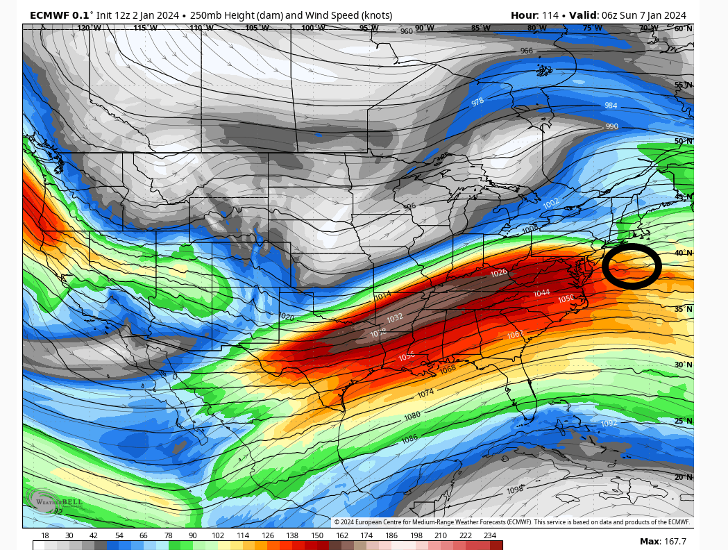
It's subtle but I believe it does make a significant difference in how the storm consolidates and rapidly deepens also it's reinforcing colder air at the mid levels.
northern stream
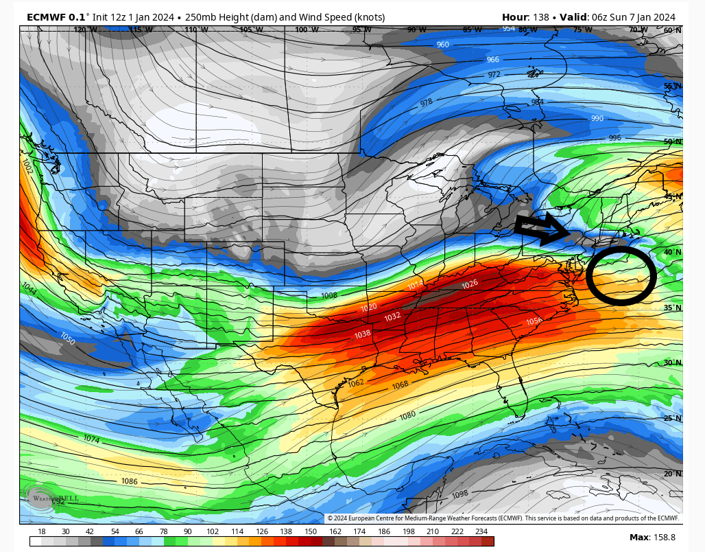
no northern stream shown
heehaw453- Advanced Forecaster

- Posts : 3906
Reputation : 86
Join date : 2014-01-20
Location : Bedminster Township, PA Elevation 600' ASL
 Re: January 2024 Observations and Discussion
dsix85 wrote:Bernie said the only wrinkle is if the system maintains its energy as it gets towards the coast. The Canadian shows it getting a bit strung out. He made it a point that there’s a fresh injection of cold air so most of NYC Metro could be in store for a 3-6+ event. He conveniently left out Long Island! But did mention it’s an ideal track for NYC.
Have to see how the day to day shifts in the model ultimately play out but it is good to see that we are at least in the game for this one and have something to track. Seeing a bit of a NW shift this far out is not uncommon this far out and neither is seeing it shift SE with time as we get closer is also not uncommon so we track and yes hope
phil155- Pro Enthusiast

- Posts : 483
Reputation : 4
Join date : 2019-12-16
essexcountypete likes this post
 Re: January 2024 Observations and Discussion
sroc4 wrote:heehaw453 wrote:All the models today 12Z are showing very little if any n/s interaction. Of course tomorrow is another story but you'd want to see that trend stop and reverse course tomorrow. This won't be be a Godzilla for anyone IMO unless we get that phasing at the right time. Can still be a nice event for NW I95 though. Hell I'd take 3-6" right now sign on the dotted line.
I dont think this is an interaction with the n/s issue. This is a southern system that comes into a cold antecedent air mass. Question is how consolidated is the enrgy at our latitude. Biggest solns showed a closed low and strong vort. Latest trends on euro have been to not have as consolidated energy. That's a problem.
12z yesterday 00z then 12z today
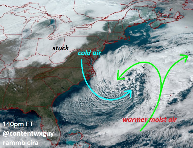
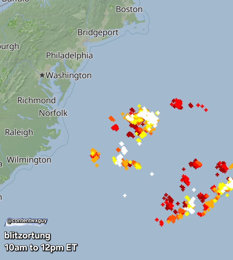
The track holds course as I posted from ConentWx Guy - it will follow that thermal profile.
Yes there is a piece of energy models have missed or did not take into account that is starting show up causing the weaker solutions.
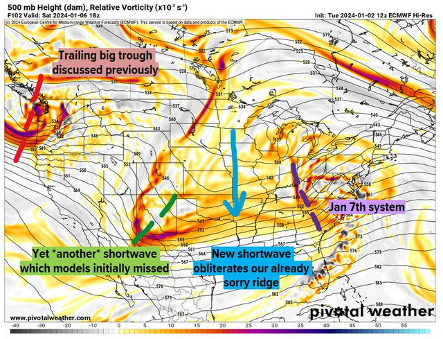
The 50/50 LP will explode soon as we have this latent heat release
_________________
Mugs
AKA:King: Snow Weenie
Self Proclaimed
WINTER 2014-15 : 55.12" +.02 for 6 coatings (avg. 35")
WINTER 2015-16 Total - 29.8" (Avg 35")
WINTER 2016-17 : 39.5" so far

amugs- Advanced Forecaster - Mod

- Posts : 15095
Reputation : 213
Join date : 2013-01-07
Age : 54
Location : Hillsdale,NJ
 Re: January 2024 Observations and Discussion
Tracks have not been our problem for the most part with storms this season. And I don't think this one will either per se. But it will need to deepen some how some way.
heehaw453- Advanced Forecaster

- Posts : 3906
Reputation : 86
Join date : 2014-01-20
Location : Bedminster Township, PA Elevation 600' ASL
 Re: January 2024 Observations and Discussion
Any chance this bombs out?
@Sroc- my neighbor and friend. You are correct, my point was he didn’t go into Uber specifics on accumulations for Long Island.
@Sroc- my neighbor and friend. You are correct, my point was he didn’t go into Uber specifics on accumulations for Long Island.
dsix85- Pro Enthusiast

- Posts : 349
Reputation : 8
Join date : 2014-01-01
Location : New York
sroc4 likes this post
 Re: January 2024 Observations and Discussion
dsix85 wrote:Bernie said the only wrinkle is if the system maintains its energy as it gets towards the coast. The Canadian shows it getting a bit strung out. He made it a point that there’s a fresh injection of cold air so most of NYC Metro could be in store for a 3-6+ event. He conveniently left out Long Island! But did mention it’s an ideal track for NYC.
He mentioned LI right after saying it's an ideal track for NYC... "even all of Long Island...I hear about how warm the water is, I get it, but still, you've got a ESE flow here, with a storm track to your south and plenty of cold air [north]..."
But like you pointed out, he qualifies it almost immediately..."I am slightly concerned that it could weaken, and if it weakens we would not be looking at a big storm."
Downstream energy could weaken the incoming low, and then....sigh

essexcountypete- Pro Enthusiast

- Posts : 783
Reputation : 12
Join date : 2013-12-09
Location : Bloomfield, NJ
 Re: January 2024 Observations and Discussion
heehaw453 wrote:sroc4 wrote:heehaw453 wrote:All the models today 12Z are showing very little if any n/s interaction. Of course tomorrow is another story but you'd want to see that trend stop and reverse course tomorrow. This won't be be a Godzilla for anyone IMO unless we get that phasing at the right time. Can still be a nice event for NW I95 though. Hell I'd take 3-6" right now sign on the dotted line.
I dont think this is an interaction with the n/s issue. This is a southern system that comes into a cold antecedent air mass. Question is how consolidated is the enrgy at our latitude. Biggest solns showed a closed low and strong vort. Latest trends on euro have been to not have as consolidated energy. That's a problem.
12z yesterday 00z then 12z today
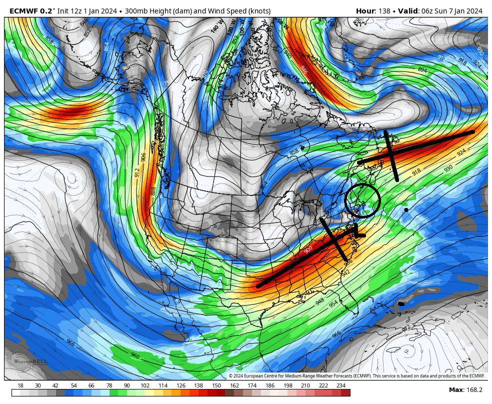
It's subtle but I believe it does make a significant difference in how the storm consolidates and rapidly deepens also it's reinforcing colder air at the mid levels.
northern stream
no northern stream shown
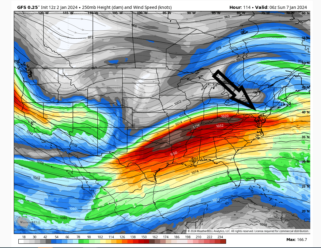
But what your showing is a 250mb wind map. You have to zoom out a little to see the northern jet. Normally you find the greatest verticle forcing in the Right rear or left front quadrants of a jet streak. Thats where pressures will tend to want to drop the fastest. The biggest difference I see from yest 12z to todays 12z on the euro is today the Northern branch is further north and much weaker. The low is centered poorly to have any help from the southen branch jet streak as modeled. In addition at 500mb like the vort maps indicate the vorticity is way more sporead out; less reds that the prev two runs.

_________________
"In weather and in life, there's no winning and losing; there's only winning and learning."
WINTER 2012/2013 TOTALS 43.65"WINTER 2017/2018 TOTALS 62.85" WINTER 2022/2023 TOTALS 4.9"
WINTER 2013/2014 TOTALS 64.85"WINTER 2018/2019 TOTALS 14.25" WINTER 2023/2024 TOTALS 13.1"
WINTER 2014/2015 TOTALS 71.20"WINTER 2019/2020 TOTALS 6.35"
WINTER 2015/2016 TOTALS 35.00"WINTER 2020/2021 TOTALS 37.75"
WINTER 2016/2017 TOTALS 42.25"WINTER 2021/2022 TOTALS 31.65"

sroc4- Admin

- Posts : 8354
Reputation : 302
Join date : 2013-01-07
Location : Wading River, LI
 Re: January 2024 Observations and Discussion
heehaw453 wrote:Tracks have not been our problem for the most part with storms this season. And I don't think this one will either per se. But it will need to deepen some how some way.
More consolidated vorticity at 500 and or better positioned and stronger jet streak
_________________
"In weather and in life, there's no winning and losing; there's only winning and learning."
WINTER 2012/2013 TOTALS 43.65"WINTER 2017/2018 TOTALS 62.85" WINTER 2022/2023 TOTALS 4.9"
WINTER 2013/2014 TOTALS 64.85"WINTER 2018/2019 TOTALS 14.25" WINTER 2023/2024 TOTALS 13.1"
WINTER 2014/2015 TOTALS 71.20"WINTER 2019/2020 TOTALS 6.35"
WINTER 2015/2016 TOTALS 35.00"WINTER 2020/2021 TOTALS 37.75"
WINTER 2016/2017 TOTALS 42.25"WINTER 2021/2022 TOTALS 31.65"

sroc4- Admin

- Posts : 8354
Reputation : 302
Join date : 2013-01-07
Location : Wading River, LI
Page 2 of 26 •  1, 2, 3 ... 14 ... 26
Page 2 of 26
Permissions in this forum:
You cannot reply to topics in this forum|
|
|

 Home
Home