JAN 6th-7th Storm Thread I
+22
Coachgriff
CPcantmeasuresnow
phil155
docstox12
Artechmetals
Dunnzoo
DAYBLAZER
sroc4
frank 638
billg315
Irish
tomsriversnowstorm
dsix85
aiannone
amugs
SENJsnowman
rb924119
heehaw453
nutleyblizzard
jmanley32
dkodgis
Frank_Wx
26 posters
Page 1 of 16
Page 1 of 16 • 1, 2, 3 ... 8 ... 16 
 JAN 6th-7th Storm Thread I
Hello all
I am back from vacation and spent time digesting all the model runs and analysis provided here by our members. It is time for our first storm thread of the season! I wrote up a blog to share my thoughts.
First Snowstorm of 2024
Also, here is my probability map of seeing at least 3" of snow this weekend. Read the blog to understand my reasoning.

_________________
_______________________________________________________________________________________________________
CLICK HERE to view NJ Strong Snowstorm Classifications
kalleg and heehaw453 like this post
 Re: JAN 6th-7th Storm Thread I
Too soon I know but will this storm peter out by Sunday morning or continue into the day?

dkodgis- Senior Enthusiast

- Posts : 2560
Reputation : 98
Join date : 2013-12-29
dkodgis likes this post
 Re: JAN 6th-7th Storm Thread I
Thanks for the explanation Frank, hope you had a good time on your trip. Not going to lie I am going to expect rain for me from what you are stating. At a 25% change thats not mcuh, I would not place a bet on 25% for anything. Granted I get there are some changes that could happen but it seems like it may just not be good for my area and by a hair too. So CP if ur hearing me or see this, you should be happy with this map 50/75%, your complaints look like they are not going to be needed. I really have not gotten my hopes up for this storm from the start, which I am glad of because if this continues to look this way then I will just hope it passes so far south that its sunny, I really cannot deal with anymore rain, it just plain sucks. But heres to praying for a miracle I guess, and hope you are wrong and we see a CMC solution (unlikely though). And yes I did read your whole blog, did not understand all of it so feel free to give feedback to my disheartened response if it is not warrented.

jmanley32- Senior Enthusiast

- Posts : 20535
Reputation : 108
Join date : 2013-12-12
Age : 43
Location : Yonkers, NY
 Re: JAN 6th-7th Storm Thread I
18z GFS starting to cave. More amped with a snowier solution.

nutleyblizzard- Senior Enthusiast

- Posts : 1954
Reputation : 41
Join date : 2014-01-30
Age : 58
Location : Nutley, new jersey
rb924119, jmanley32 and heehaw453 like this post
 Re: JAN 6th-7th Storm Thread I
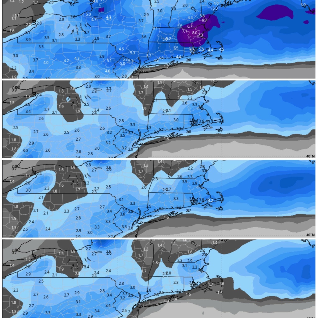
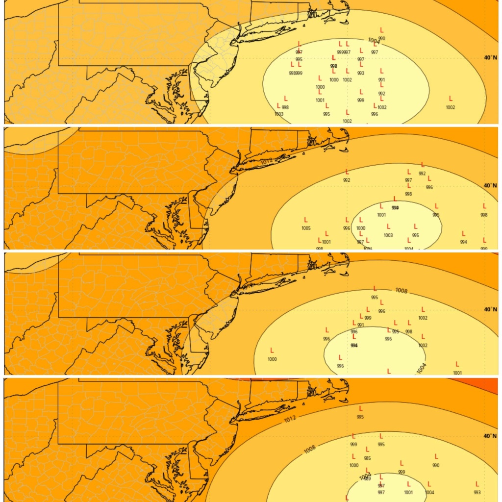
Also of note is the ULL as the 500mb trough swings through Sunday afternoon it will probably produce snowfall. Now if the ULL catches up with the mid-levels and surface forget it. All bets are off with this thing. It'll explode mid 980s and that would be nirvana. I doubt it as the trough isn't negative but we also have a plugged up atmosphere. The point is keep an open mind with this. There are things synoptically that can surprise the heck out of you with this setup in regard to the forecast.

I should be clear here. It does catch up but a bit too late for our benefit as it's past the benchmark. As modelled it would enhance SNE snowfall.

I should be clear here. It does catch up but a bit too late for our benefit as it's past the benchmark. As modelled it would enhance SNE snowfall.
Last edited by heehaw453 on Wed Jan 03, 2024 5:58 pm; edited 1 time in total
heehaw453- Advanced Forecaster

- Posts : 3906
Reputation : 86
Join date : 2014-01-20
Location : Bedminster Township, PA Elevation 600' ASL
jmanley32 likes this post
 Re: JAN 6th-7th Storm Thread I
It really did make a massive change for the better, still keeps my area on the low end but just a small tick forther SE and game on. Does this still have godzilla potential or not so much anymore? Looking more like a possible mothra?nutleyblizzard wrote:18z GFS starting to cave. More amped with a snowier solution.

Last edited by jmanley32 on Wed Jan 03, 2024 5:37 pm; edited 1 time in total

jmanley32- Senior Enthusiast

- Posts : 20535
Reputation : 108
Join date : 2013-12-12
Age : 43
Location : Yonkers, NY
rb924119- Meteorologist

- Posts : 6928
Reputation : 194
Join date : 2013-02-06
Age : 32
Location : Greentown, Pa
docstox12, amugs, Dunnzoo, Grselig, nancy-j-s, jmanley32, heehaw453 and billg315 like this post
 Re: JAN 6th-7th Storm Thread I
I failed to mention this in the write up, but I agree with heehaw that there’s lingering snow into Sunday afternoon in the form of a big CCB or inverted trough. I like the CCB potential. Areas north of NYC would benefit most from it, but I can see an inch or two elsewhere.
_________________
_______________________________________________________________________________________________________
CLICK HERE to view NJ Strong Snowstorm Classifications
 Re: JAN 6th-7th Storm Thread I
Frank welcome home and I hope you and your bride had a beautiful honeymoon and more importantly that you two have a blessed and loving lifetime together.
If I recall correct, your SCI measures the likelihood of 1” of snow falling in Central Park. Or is it just NYC generally speaking? Either way, do you still like 75% for that number or is it going to get lowered without a big change in guidance? Just wondering…
If I recall correct, your SCI measures the likelihood of 1” of snow falling in Central Park. Or is it just NYC generally speaking? Either way, do you still like 75% for that number or is it going to get lowered without a big change in guidance? Just wondering…
SENJsnowman- Senior Enthusiast

- Posts : 1189
Reputation : 61
Join date : 2017-01-06
Age : 51
Location : Bayville, NJ
 Re: JAN 6th-7th Storm Thread I
Recon flights tomorrow for WC and Gulf on Friday.
Question, why use OP when they wafflesd and have been like no tomorrow over ENS??
If tjis gets strung out killed , your the mush and will be banished from ever starting another thread until the Rulers of each sector of OTI vote for.....unanimously....LOL!!
Question, why use OP when they wafflesd and have been like no tomorrow over ENS??
If tjis gets strung out killed , your the mush and will be banished from ever starting another thread until the Rulers of each sector of OTI vote for.....unanimously....LOL!!
_________________
Mugs
AKA:King: Snow Weenie
Self Proclaimed
WINTER 2014-15 : 55.12" +.02 for 6 coatings (avg. 35")
WINTER 2015-16 Total - 29.8" (Avg 35")
WINTER 2016-17 : 39.5" so far

amugs- Advanced Forecaster - Mod

- Posts : 15095
Reputation : 213
Join date : 2013-01-07
Age : 54
Location : Hillsdale,NJ
 Re: JAN 6th-7th Storm Thread I
_________________
Mugs
AKA:King: Snow Weenie
Self Proclaimed
WINTER 2014-15 : 55.12" +.02 for 6 coatings (avg. 35")
WINTER 2015-16 Total - 29.8" (Avg 35")
WINTER 2016-17 : 39.5" so far

amugs- Advanced Forecaster - Mod

- Posts : 15095
Reputation : 213
Join date : 2013-01-07
Age : 54
Location : Hillsdale,NJ
 Re: JAN 6th-7th Storm Thread I
When is the precip supposed to start? Gonna be in eastern CT Sat possibly and want to get back before anything starts even if it is rain id like to have a idea now if I should go or not.
You know one thing occured to me theres gonna be ALOT of accidents even if a little snow, why? Because its been 2 years for most at least down here and people didn't know how to drive in snow before...I may even be rusty.
You know one thing occured to me theres gonna be ALOT of accidents even if a little snow, why? Because its been 2 years for most at least down here and people didn't know how to drive in snow before...I may even be rusty.

jmanley32- Senior Enthusiast

- Posts : 20535
Reputation : 108
Join date : 2013-12-12
Age : 43
Location : Yonkers, NY
 Re: JAN 6th-7th Storm Thread I
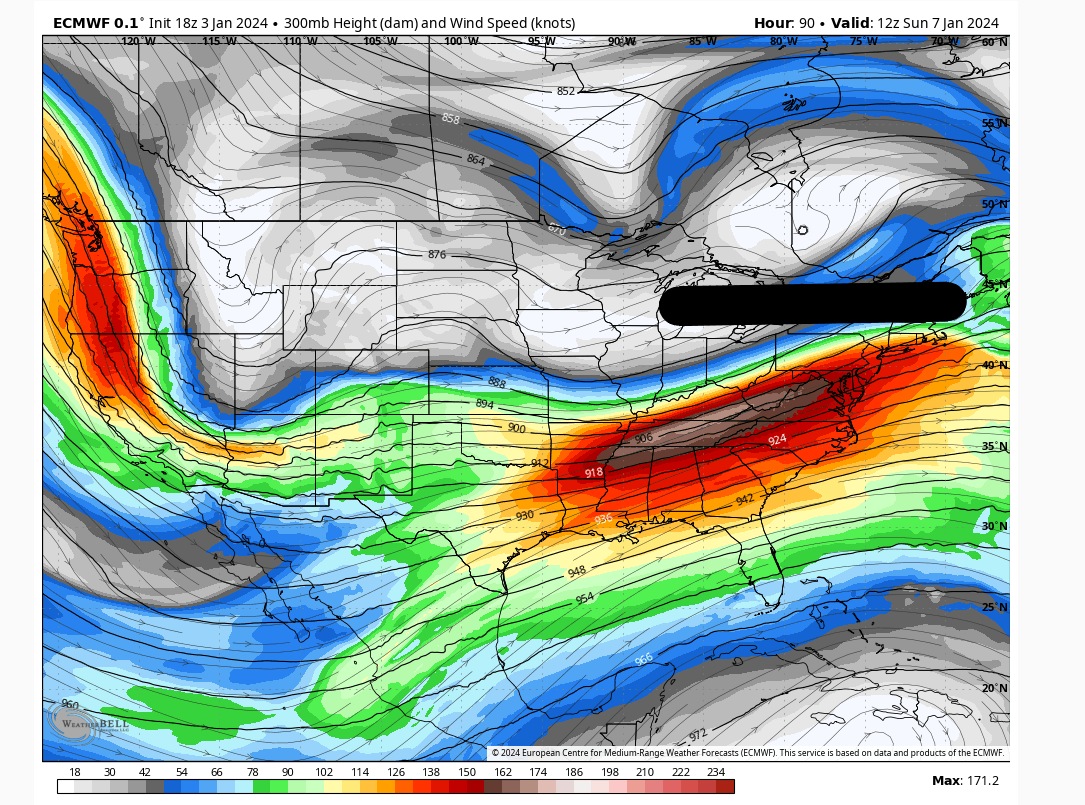
One thing is becoming is becoming clear there is a lot of mid-level energy that is being pushed up by the s/s jet.
I want to see this n/s jet compress the flow a bit more to 1/keep the storm more easterly, 2/force earlier consolidation. If those two things can occur then I think this turns into something we only are getting glimpses of from time to time.
18Z Euro

I want to see this n/s jet compress the flow a bit more to 1/keep the storm more easterly, 2/force earlier consolidation. If those two things can occur then I think this turns into something we only are getting glimpses of from time to time.
18Z Euro

heehaw453- Advanced Forecaster

- Posts : 3906
Reputation : 86
Join date : 2014-01-20
Location : Bedminster Township, PA Elevation 600' ASL
 Re: JAN 6th-7th Storm Thread I
SENJsnowman wrote:Frank welcome home and I hope you and your bride had a beautiful honeymoon and more importantly that you two have a blessed and loving lifetime together.
If I recall correct, your SCI measures the likelihood of 1” of snow falling in Central Park. Or is it just NYC generally speaking? Either way, do you still like 75% for that number or is it going to get lowered without a big change in guidance? Just wondering…
Good question. You’re correct…SCI is the probability of 1” or more of accumulating snowfall in NYC. Yes I’m sticking with 75% for now. I have NYC at 25% for 3” or more. So it gives you an idea of where my head is at for the coast.
amugs wrote:Recon flights tomorrow for WC and Gulf on Friday.
Question, why use OP when they wafflesd and have been like no tomorrow over ENS??
If tjis gets strung out killed , your the mush and will be banished from ever starting another thread until the Rulers of each sector of OTI vote for.....unanimously....LOL!!
Haha, well I hope it doesn’t dissipate into nothing. The STJ won’t allow that to happen anyway. To answer your question, I like to use OPs inside of 5 days because I can get into more details. However I still very much take into consideration the ensembles. Especially for the track of the low.
I also rely on my instincts. Just based on what I see in the upper levels, I’m not buying any model showing snow amounts of 6” or more in NYC.
jmanley32 wrote:When is the precip supposed to start? Gonna be in eastern CT Sat possibly and want to get back before anything starts even if it is rain id like to have a idea now if I should go or not.
You know one thing occured to me theres gonna be ALOT of accidents even if a little snow, why? Because its been 2 years for most at least down here and people didn't know how to drive in snow before...I may even be rusty.
Precip starts Saturday after 5pm. Almost 100% of this system comes at night. At least the “main” event does. Lingering snow possible through Sunday afternoon.
_________________
_______________________________________________________________________________________________________
CLICK HERE to view NJ Strong Snowstorm Classifications
SENJsnowman likes this post
 Re: JAN 6th-7th Storm Thread I
Woaaah, latest SREFS are really amped. I wonder if this will be the run that the NAM wakes up……
rb924119- Meteorologist

- Posts : 6928
Reputation : 194
Join date : 2013-02-06
Age : 32
Location : Greentown, Pa
 Re: JAN 6th-7th Storm Thread I
Anyone see the RGEM? That would really disappoint lol
_________________
-Alex Iannone-

aiannone- Senior Enthusiast - Mod

- Posts : 4815
Reputation : 92
Join date : 2013-01-07
Location : Saint James, LI (Northwest Suffolk Co.)
 Re: JAN 6th-7th Storm Thread I
Any chance that this moves slower and explodes off the coast of LI?
dsix85- Pro Enthusiast

- Posts : 349
Reputation : 8
Join date : 2014-01-01
Location : New York
 Re: JAN 6th-7th Storm Thread I
Why are you excited about it being amped. I know many times when these things are amped it leads to us in New Jersey getting rain?
rb924119 wrote:Woaaah, latest SREFS are really amped. I wonder if this will be the run that the NAM wakes up……
tomsriversnowstorm- Posts : 90
Reputation : 0
Join date : 2021-02-06
 Re: JAN 6th-7th Storm Thread I
I think things have started to look ugly for the 95 corridor and SE. Crazy how just 24 hours ago, it was mentioned that this storm could be a 95 special. That's the way it goes and it could shift again.

Irish- Pro Enthusiast

- Posts : 788
Reputation : 19
Join date : 2019-01-16
Age : 45
Location : Old Bridge, NJ
 Re: JAN 6th-7th Storm Thread I
Was thinking the same thing when I read rb's post. That usually means bad things.tomsriversnowstorm wrote:Why are you excited about it being amped. I know many times when these things are amped it leads to us in New Jersey getting rain?rb924119 wrote:Woaaah, latest SREFS are really amped. I wonder if this will be the run that the NAM wakes up……

Irish- Pro Enthusiast

- Posts : 788
Reputation : 19
Join date : 2019-01-16
Age : 45
Location : Old Bridge, NJ
 Re: JAN 6th-7th Storm Thread I
Irish wrote:Was thinking the same thing when I read rb's post. That usually means bad things.tomsriversnowstorm wrote:Why are you excited about it being amped. I know many times when these things are amped it leads to us in New Jersey getting rain?rb924119 wrote:Woaaah, latest SREFS are really amped. I wonder if this will be the run that the NAM wakes up……
It does result in the I-95 Corridor being an all-rain event, but the SREFS are overamplified 99% of the time. I’m looking at them as more of a hopeful sign that the NAM will improve in its 00z run, because they are based on the same dynamical core. Basically, the SREFS are like the NAM’s ensemble.
The 18z RGEM was also very amplified, though, similarly to the SREFS. However, it was an 18z run, which I don’t pay much attention to, personally.
rb924119- Meteorologist

- Posts : 6928
Reputation : 194
Join date : 2013-02-06
Age : 32
Location : Greentown, Pa
 Re: JAN 6th-7th Storm Thread I
rb924119 wrote:Irish wrote:Was thinking the same thing when I read rb's post. That usually means bad things.tomsriversnowstorm wrote:Why are you excited about it being amped. I know many times when these things are amped it leads to us in New Jersey getting rain?rb924119 wrote:Woaaah, latest SREFS are really amped. I wonder if this will be the run that the NAM wakes up……
It does result in the I-95 Corridor being an all-rain event, but the SREFS are overamplified 99% of the time. I’m looking at them as more of a hopeful sign that the NAM will improve in its 00z run, because they are based on the same dynamical core. Basically, the SREFS are like the NAM’s ensemble.
The 18z RGEM was also very amplified, though, similarly to the SREFS. However, it was an 18z run, which I don’t pay much attention to, personally.
OK, we shall see, just don't like where this is heading. There were runs where the heavy snow band was right across Central jersey and down 95. Now it looks like things are shifted to where they usually go NW.

Irish- Pro Enthusiast

- Posts : 788
Reputation : 19
Join date : 2019-01-16
Age : 45
Location : Old Bridge, NJ
 Re: JAN 6th-7th Storm Thread I
How the world turns. Yesterday the Euro was our best bet and we were hoping the GFS was out to lunch. Now the GFS is more encouraging than the Euro. lol.
My initial thought, with the caveat that we won't really zero-in on this until late tomorrow or Friday, is that the dividing line here ends up being roughly along the fall line or the I-95. I think north and west of that line is a 6-10" type snow. Along or just either side of that line is about 3-5" with rain mixing in the middle before ending as snow. And South and east mostly rain with maybe some snow at the outset Saturday evening and lighter back-end snows Sunday AM.
This is a very rough estimate -- which is about all I think anyone can give at this stage with the models still waffling.

billg315- Advanced Forecaster - Mod

- Posts : 4483
Reputation : 185
Join date : 2015-01-24
Age : 50
Location : Flemington, NJ
sroc4, Dunnzoo, essexcountypete and phil155 like this post
 Re: JAN 6th-7th Storm Thread I
Yea I am hoping the pattern shifts and we can get some snow chances later in the month and February. Just too warm right now. I will say this has been fun to watch and learn.
billg315 wrote:How the world turns. Yesterday the Euro was our best bet and we were hoping the GFS was out to lunch. Now the GFS is more encouraging than the Euro. lol.
My initial thought, with the caveat that we won't really zero-in on this until late tomorrow or Friday, is that the dividing line here ends up being roughly along the fall line or the I-95. I think north and west of that line is a 6-10" type snow. Along or just either side of that line is about 3-5" with rain mixing in the middle before ending as snow. And South and east mostly rain with maybe some snow at the outset Saturday evening and lighter back-end snows Sunday AM.
This is a very rough estimate -- which is about all I think anyone can give at this stage with the models still waffling.
tomsriversnowstorm- Posts : 90
Reputation : 0
Join date : 2021-02-06
 Re: JAN 6th-7th Storm Thread I
NAM woke up. Looks a lot better than it did today lol
rb924119- Meteorologist

- Posts : 6928
Reputation : 194
Join date : 2013-02-06
Age : 32
Location : Greentown, Pa
Page 1 of 16 • 1, 2, 3 ... 8 ... 16 
Page 1 of 16
Permissions in this forum:
You cannot reply to topics in this forum|
|
|

 Home
Home


