JAN 6th-7th Storm Thread I
+22
Coachgriff
CPcantmeasuresnow
phil155
docstox12
Artechmetals
Dunnzoo
DAYBLAZER
sroc4
frank 638
billg315
Irish
tomsriversnowstorm
dsix85
aiannone
amugs
SENJsnowman
rb924119
heehaw453
nutleyblizzard
jmanley32
dkodgis
Frank_Wx
26 posters
Page 3 of 16
Page 3 of 16 •  1, 2, 3, 4 ... 9 ... 16

aiannone- Senior Enthusiast - Mod

- Posts : 4815
Reputation : 92
Join date : 2013-01-07
Location : Saint James, LI (Northwest Suffolk Co.)
 Re: JAN 6th-7th Storm Thread I
Frank_Wx wrote:rb924119 wrote:Frank_Wx wrote:jmanley32 wrote:If CP comes back on here with his doom and gloom with this look for the storm I will lose my you know what lol. What does it need to do to shift the cold enough to the coast to see more than 2 inches (I mean NYC and my area, not LI, sorry LIlooks like this may be a tough one.
Refer to my blog post. The true cold air is up in Canada. The current air mass is cold enough for snow, but it’s pretty marginal for the coast.
Welcome back, fearless leader!
I'm going to respectfully disagree that the airmass is marginal for the coast (aside from the lowest levels, i.e. sub-950 hPa). This actually gets back to a question that @Dunnzoo asked me earlier, about snow ratios, as well, in that the airmass that we will have in place is largely very conducive for snow, especially if we get the subtle southward shift that I am expecting. Here's a look at a sounding from the Euro for KNYC during the heart of the storm:
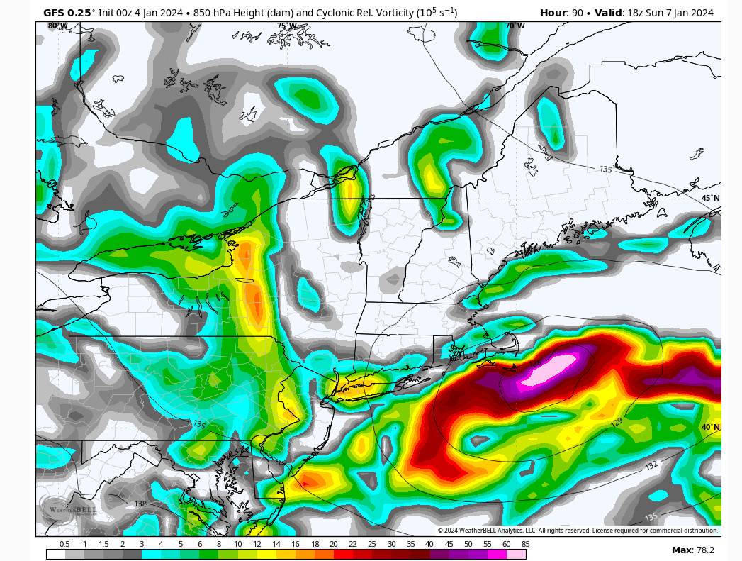
Note how I have the temperatures annotated on multiple levels in blue (in ºC). In order to assess the thermal profile, and get an accurate representation the atmosphere, you have to first figure out where your forcing mechanisms are located in the vertical. For example, there are some situations where you have strong mid-level forcing, but very little help from an upper-level jet or lower-level frontogenesis. In that case, you would want to weight your thermal profile calculations accordingly to account for that. In this, case, though, we have decent forcing for ascent throughout the atmospheric column. We have lower-level frontogenesis, mid-level vorticity advection, and upper-level jet support from AT LEAST one jet streak, arguably two, in my opinion. So, we can equally weight each temperature reading at each level, and we take a temperature reading through the atmospheric column until we run out of forcing (basically when we get to jet level). So, if you subtract all of those numbers (since they are negatives) you get the following:
9 total readings = -133
Divide the -133/9 to get the average temperature of the atmospheric column, through which you're getting ascent and snow development: -14.8ºC.
Ok, now this is where it gets interesting, because this value gives you information for two things: Snow ratios and crystal formation tendencies.
Let's look at snow ratios first:
Temperature runs along the bottom, ratio along the vertical axis. As you can see, based on the average temperature of our column, you exceed 20:1. Now, this is not stagnant - as the storm evolves, so does your average atmospheric temperature. But, I've already looked and this generally remains fairly steady-state. However, lets play it conservative and say you lose some snow to melting while cooling the lower column initially, and say your average snowfall ratio will be somewhere between 18-20:1.
Next, let's look at crystal formation tendency based on our average atomspheric temperature:
As you can see, we are right in the sweet spot for plates and dendrites - the most efficient snowfall accumulators.
If you apply this to the average output of liquid equivalency among the major models (~1"), you can see how I was estimating my upper bound as 18-20" with this event.
Dunnz, hopefully that clarifies a bit for ya
This is fantastic! The science makes perfect sense. Where I’ll disagree, and try to provide more data tomorrow, is with this part:
In this, case, though, we have decent forcing for ascent throughout the atmospheric column. We have lower-level frontogenesis, mid-level vorticity advection, and upper-level jet support from AT LEAST one jet streak, arguably two, in my opinion. So, we can equally weight each temperature reading at each level
Specifically upper level jet support and mid level vorticity is questionable to me. At least at this time. No doubt we have the southern jet helping to usher mid level vorticity into the main system, but the timing at which this all comes together concerns me. I think if you were to take this temperature reading for Boston, then you can apply this logic and get an accurate number. But I think there’s some pieces missing right now for NYC. Basically you’re saying if NYC sees 1” of qpf, they will get 18” of snow? I’m having a hard time even believing 30% of that number right now haha.
I was just about to clarify further haha that was based on an earlier discussion, back when guidance was still showing more robust mid-levels, with a severely negatively-tilted/closing H5 low. that was enhancing moisture fetch off the Atlantic on top of the moisture it drew from the Gulf. Now, however, the PWAT anomalies are less anomalous, closer to about 1-sigma, which makes sense, given the deep southwesterly flow, with only limited time to access the Gulf and no support from the Atlantic. this makes me think that the general QPF from the storm will be closer to the 0.6-1" range. You figure you lose a couple tenths of that to melting in the column, plus another 0.1-0.2 tenths to contact melting (in the City), and now you're down to a max of about 0.7" of QPF that would fall as snow and accumulate. Based on the numbers, you're looking at a ceiling in KNYC of roughly 1 foot, and a 10:1 value of approximately 7". Given that all all three global ensembles are not far off from that 7" 10:1 value, I'd say my approximations are fairly close.
This also counters my earlier argument that we would expect to see a robust jet to the northeast of the storm, although I do still think we will have one, similarly to what the GEM has been showing. I think the Euro and GFS have been poor in representing this feature. It just won't be as strong as I previously thought.
rb924119- Meteorologist

- Posts : 6931
Reputation : 194
Join date : 2013-02-06
Age : 32
Location : Greentown, Pa
Frank_Wx likes this post
heehaw453- Advanced Forecaster

- Posts : 3906
Reputation : 86
Join date : 2014-01-20
Location : Bedminster Township, PA Elevation 600' ASL
rb924119 likes this post
 Re: JAN 6th-7th Storm Thread I
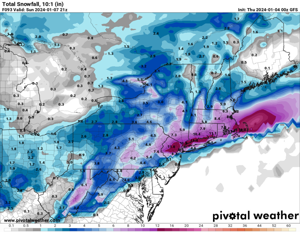
Well, at least the GFS shows that my ideas still have merit 
rb924119- Meteorologist

- Posts : 6931
Reputation : 194
Join date : 2013-02-06
Age : 32
Location : Greentown, Pa
 Re: JAN 6th-7th Storm Thread I
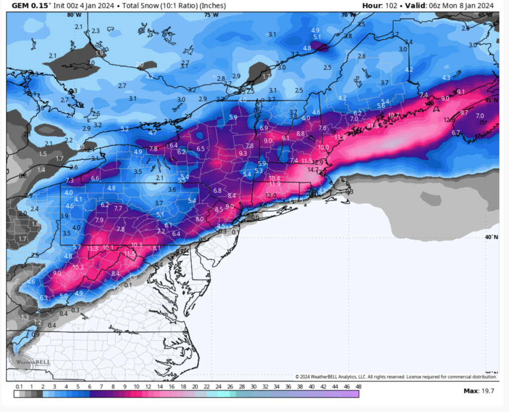
CMC is quite tucked in. Rain for NYC points east. Southern New England is the jackpot
_________________
-Alex Iannone-

aiannone- Senior Enthusiast - Mod

- Posts : 4815
Reputation : 92
Join date : 2013-01-07
Location : Saint James, LI (Northwest Suffolk Co.)
rb924119- Meteorologist

- Posts : 6931
Reputation : 194
Join date : 2013-02-06
Age : 32
Location : Greentown, Pa
 Re: JAN 6th-7th Storm Thread I
The GFS and GEM are 25 miles from jack potting I-95 lol four days out. This isn't over by a long shot folks.
rb924119- Meteorologist

- Posts : 6931
Reputation : 194
Join date : 2013-02-06
Age : 32
Location : Greentown, Pa
oldtimer and heehaw453 like this post
 Re: JAN 6th-7th Storm Thread I
rb924119 wrote:The GFS and GEM are 25 miles from jack potting I-95 lol four days out. This isn't over by a long shot folks.
Tomorrow is another day. Im rooting for you lol ray! lol. The gfs almost showed your initial thoughts from last weekend

aiannone- Senior Enthusiast - Mod

- Posts : 4815
Reputation : 92
Join date : 2013-01-07
Location : Saint James, LI (Northwest Suffolk Co.)
 Re: JAN 6th-7th Storm Thread I
The CMC is a much more consolidated representation of mid-levels and something like that could drop 6-12" just move it 50-75 miles SE for the I95.
heehaw453- Advanced Forecaster

- Posts : 3906
Reputation : 86
Join date : 2014-01-20
Location : Bedminster Township, PA Elevation 600' ASL
docstox12 and rb924119 like this post
 Re: JAN 6th-7th Storm Thread I
I84 and above enjoy this storm. It looks like your goose is cooked below this point. Hell, those in central and Southern NJ might just see an all rain event, with maybe some mixing here and there. And the next midweek storm looks to be all rain as well. The next check in looks to be for the 15th-20th time frame. GL to those up north and west.

Irish- Pro Enthusiast

- Posts : 788
Reputation : 19
Join date : 2019-01-16
Age : 45
Location : Old Bridge, NJ
 Re: JAN 6th-7th Storm Thread I
Synoptically not much changed.
But clearly trends yesterday are stronger s/w and less resistance from H in Quebec. It's forcing mid-level circulation to pass over SE NJ and well inside the BM before the storm moves more easterly. Too close...
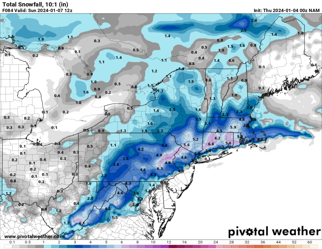
If that trends continues then I95 (NYC/LI) will be rain and EPA a sloppy inch or two. NEPA (especially > 1000'), NW NJ, LHV (Orange Cty) at least 4" with potential for more so that seems on track.
I'm NOT bought in to this just yet. I want to give it until 12Z tomorrow before my confidence is high. But today I don't think we can afford any further NW moves of the mid-levels into NJ and have enough room for guidance to correct back for aforementioned areas. So what I'm looking for today is no further movement NW and hopefully a push back SE.
Just getting too close to ignore guidance IMO...
heehaw453- Advanced Forecaster

- Posts : 3906
Reputation : 86
Join date : 2014-01-20
Location : Bedminster Township, PA Elevation 600' ASL
 Re: JAN 6th-7th Storm Thread I
Unfortunately heehaw, I think guidance will keep pressing north.heehaw453 wrote:Synoptically not much changed.
But clearly trends yesterday are stronger s/w and less resistance from H in Quebec. It's forcing mid-level circulation to pass over SE NJ and well inside the BM before the storm moves more easterly. Too close...
If that trends continues then I95 (NYC/LI) will be rain and EPA a sloppy inch or two. NEPA (especially > 1000'), NW NJ, LHV (Orange Cty) at least 4" with potential for more so that seems on track.
I'm NOT bought in to this just yet. I want to give it until 12Z tomorrow before my confidence is high. But today I don't think we can afford any further NW moves of the mid-levels into NJ and have enough room for guidance to correct back for aforementioned areas. So what I'm looking for today is no further movement NW and hopefully a push back SE.
Just getting too close to ignore guidance IMO...
As others have said, When you’re relying on stout confluence to otherwise hold back a storm that would want to go on a bad track, at our latitude we’re playing very long odds. The confluence weakens which it often does, the SE ridge strengthens which it often does.

Irish- Pro Enthusiast

- Posts : 788
Reputation : 19
Join date : 2019-01-16
Age : 45
Location : Old Bridge, NJ
 Re: JAN 6th-7th Storm Thread I
Irish wrote:Unfortunately heehaw, I think guidance will keep pressing north.heehaw453 wrote:Synoptically not much changed.
But clearly trends yesterday are stronger s/w and less resistance from H in Quebec. It's forcing mid-level circulation to pass over SE NJ and well inside the BM before the storm moves more easterly. Too close...
If that trends continues then I95 (NYC/LI) will be rain and EPA a sloppy inch or two. NEPA (especially > 1000'), NW NJ, LHV (Orange Cty) at least 4" with potential for more so that seems on track.
I'm NOT bought in to this just yet. I want to give it until 12Z tomorrow before my confidence is high. But today I don't think we can afford any further NW moves of the mid-levels into NJ and have enough room for guidance to correct back for aforementioned areas. So what I'm looking for today is no further movement NW and hopefully a push back SE.
Just getting too close to ignore guidance IMO...
As others have said, When you’re relying on stout confluence to otherwise hold back a storm that would want to go on a bad track, at our latitude we’re playing very long odds. The confluence weakens which it often does, the SE ridge strengthens which it often does.
Yeah it's frustrating but the setup really is decent for the I95 on this one. But I agree with the sentiment as we're just in a snow hole for 2 years now... Sometimes weather gets into stubborn cycles and I certainly didn't like seeing December go down in flames as I've posted before.
heehaw453- Advanced Forecaster

- Posts : 3906
Reputation : 86
Join date : 2014-01-20
Location : Bedminster Township, PA Elevation 600' ASL
 Re: JAN 6th-7th Storm Thread I
Irish wrote:I84 and above enjoy this storm. It looks like your goose is cooked below this point. Hell, those in central and Southern NJ might just see an all rain event, with maybe some mixing here and there. And the next midweek storm looks to be all rain as well. The next check in looks to be for the 15th-20th time frame. GL to those up north and west.
Hi! Posts like these should be in the banter thread. A storm thread is meant for analysis, maps, questions about the storm, etc.
_________________
_______________________________________________________________________________________________________
CLICK HERE to view NJ Strong Snowstorm Classifications
 Re: JAN 6th-7th Storm Thread I
Well folks. This was a fun one to track albeit disappointing. Still have a few cycles left before it’s a total loss but this is a Boston storm as of now. Not NYC
_________________
-Alex Iannone-

aiannone- Senior Enthusiast - Mod

- Posts : 4815
Reputation : 92
Join date : 2013-01-07
Location : Saint James, LI (Northwest Suffolk Co.)
 Re: JAN 6th-7th Storm Thread I
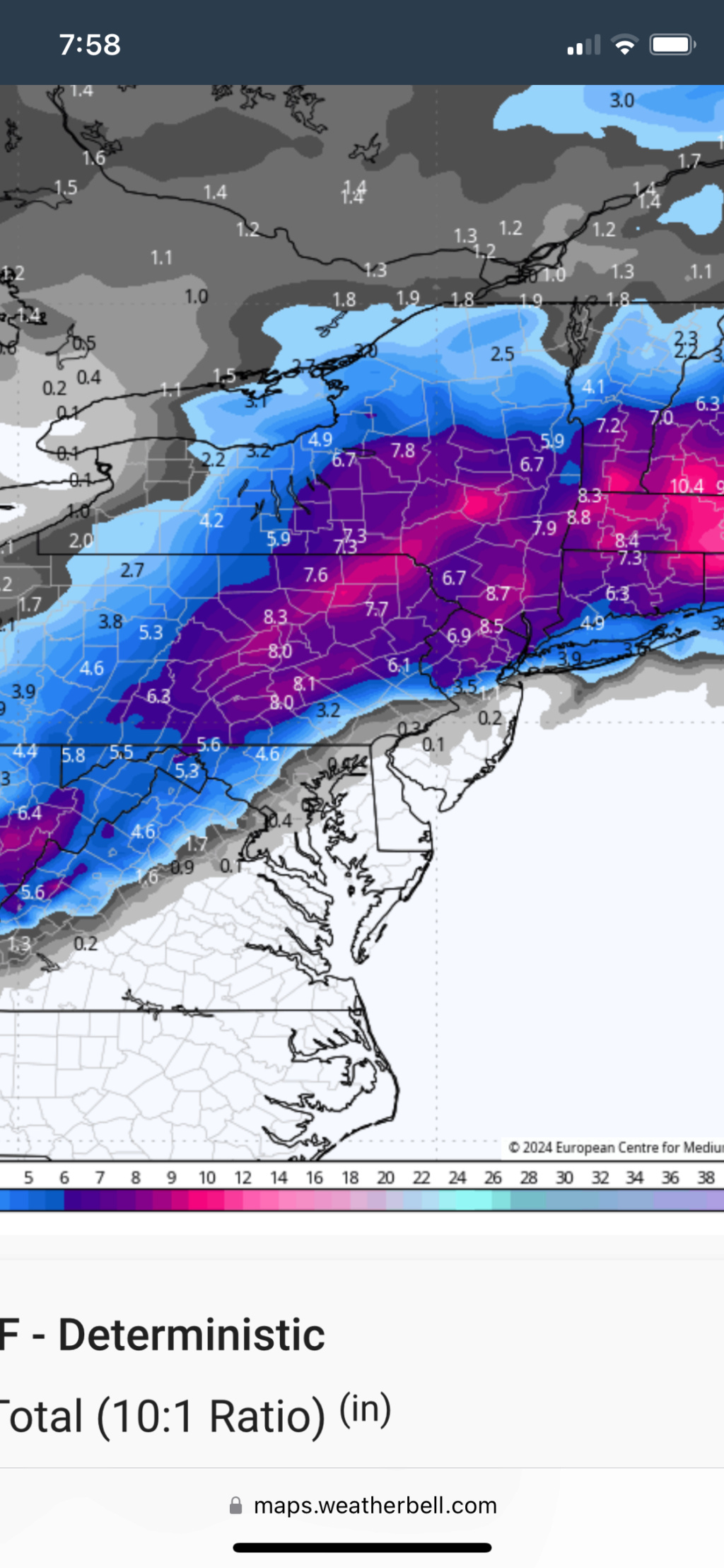
Idk why people are writing this off. 06z Euro? Way more consolidated than earlier runs, 6” into NYC. It didn’t go any further north. I’m with heehaw, and think this steadily comes back south a bit. We’ll see, but the pattern supports snow for the I-95 Corridor.
rb924119- Meteorologist

- Posts : 6931
Reputation : 194
Join date : 2013-02-06
Age : 32
Location : Greentown, Pa
jmanley32 likes this post
 Re: JAN 6th-7th Storm Thread I
Ok im back i lied. Dunno why as it is looking bleak but im go stick it out better or worse. Ill probably lurk mostly. I want the 00z gfs to verify lol. 06z was no bueno though for nyc. Frank 00z was also a jackpot for me not just mugs dunzoo verbatim. But again im skeptical and have been since we started but lets track and we see!
Last edited by jmanley32 on Thu Jan 04, 2024 7:57 am; edited 1 time in total

jmanley32- Senior Enthusiast

- Posts : 20535
Reputation : 108
Join date : 2013-12-12
Age : 43
Location : Yonkers, NY
 Re: JAN 6th-7th Storm Thread I
can we see mr. Positivityrb924119 wrote:Idk why people are writing this off. 06z Euro? Way more consolidated than earlier runs, 6” into NYC. It didn’t go any further north. I’m with heehaw, and think this steadily comes back south a bit. We’ll see, but the pattern supports snow for the I-95 Corridor.

jmanley32- Senior Enthusiast

- Posts : 20535
Reputation : 108
Join date : 2013-12-12
Age : 43
Location : Yonkers, NY
 Re: JAN 6th-7th Storm Thread I
jmanley32 wrote:can we see mr. Positivityrb924119 wrote:Idk why people are writing this off. 06z Euro? Way more consolidated than earlier runs, 6” into NYC. It didn’t go any further north. I’m with heehaw, and think this steadily comes back south a bit. We’ll see, but the pattern supports snow for the I-95 Corridor.
rb924119- Meteorologist

- Posts : 6931
Reputation : 194
Join date : 2013-02-06
Age : 32
Location : Greentown, Pa
 Re: JAN 6th-7th Storm Thread I
nice but way to close for comfort. Verbatim thats about 6 here.rb924119 wrote:jmanley32 wrote:can we see mr. Positivityrb924119 wrote:Idk why people are writing this off. 06z Euro? Way more consolidated than earlier runs, 6” into NYC. It didn’t go any further north. I’m with heehaw, and think this steadily comes back south a bit. We’ll see, but the pattern supports snow for the I-95 Corridor.

jmanley32- Senior Enthusiast

- Posts : 20535
Reputation : 108
Join date : 2013-12-12
Age : 43
Location : Yonkers, NY
 Re: JAN 6th-7th Storm Thread I
jmanley32 wrote:nice but way to close for comfort. Verbatim thats about 6 here.rb924119 wrote:jmanley32 wrote:can we see mr. Positivityrb924119 wrote:Idk why people are writing this off. 06z Euro? Way more consolidated than earlier runs, 6” into NYC. It didn’t go any further north. I’m with heehaw, and think this steadily comes back south a bit. We’ll see, but the pattern supports snow for the I-95 Corridor.
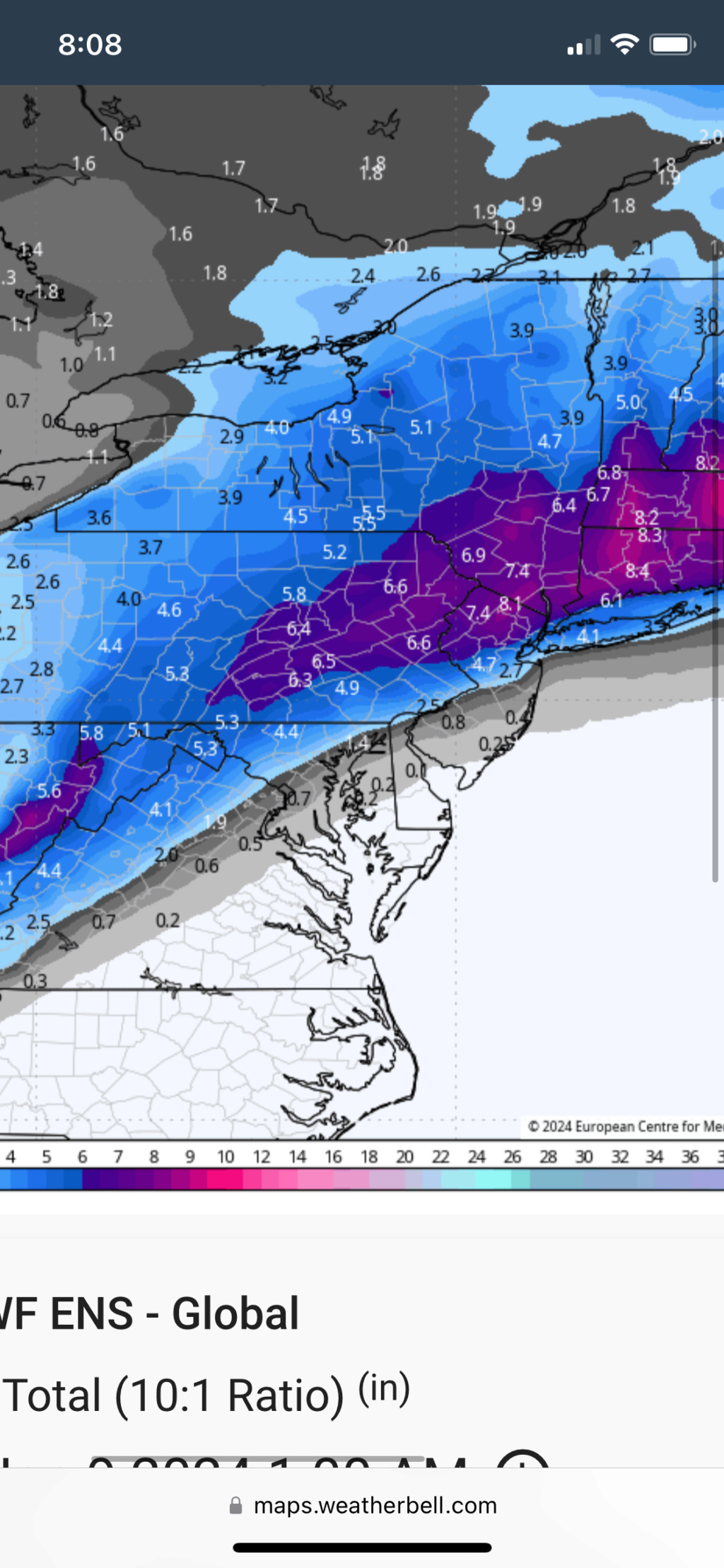
Here’s the 06z ensemble:
rb924119- Meteorologist

- Posts : 6931
Reputation : 194
Join date : 2013-02-06
Age : 32
Location : Greentown, Pa
jmanley32 likes this post
 Re: JAN 6th-7th Storm Thread I
I appreciate the optimism ray. But besides the exact track of the low I guess we have to consider the mesoscale features upton is pointing out and the major one is the coastal front. That is the kiss of death for LI and NYC and they are expecting one to develop sending warm ocean winds right into us.
_________________
-Alex Iannone-

aiannone- Senior Enthusiast - Mod

- Posts : 4815
Reputation : 92
Join date : 2013-01-07
Location : Saint James, LI (Northwest Suffolk Co.)
 Re: JAN 6th-7th Storm Thread I
SREFs are definitely wetter, no more amplified than they were previously. This is a good sign to me, but we’ll see how today goes.
Last edited by rb924119 on Thu Jan 04, 2024 8:29 am; edited 2 times in total
rb924119- Meteorologist

- Posts : 6931
Reputation : 194
Join date : 2013-02-06
Age : 32
Location : Greentown, Pa
jmanley32 likes this post
 Re: JAN 6th-7th Storm Thread I
aiannone wrote:I appreciate the optimism ray. But besides the exact track of the low I guess we have to consider the mesoscale features upton is pointing out and the major one is the coastal front. That is the kiss of death for LI and NYC and they are expecting one to develop sending warm ocean winds right into us.
It’s not optimism - I’m not blindly saying that it’ll come back. I have reasons for it based on the whole pattern and forcing mechanisms in play.
If I had reasons to think that it will continue to trend north/warmer, I’d say so.
rb924119- Meteorologist

- Posts : 6931
Reputation : 194
Join date : 2013-02-06
Age : 32
Location : Greentown, Pa
jmanley32 likes this post
 Re: JAN 6th-7th Storm Thread I
rb924119 wrote:Idk why people are writing this off. 06z Euro? Way more consolidated than earlier runs, 6” into NYC. It didn’t go any further north. I’m with heehaw, and think this steadily comes back south a bit. We’ll see, but the pattern supports snow for the I-95 Corridor.
Even if NYC is outside of the heaviest snow axis, I prefer if people do not make definitive statements of the storm being “over” because we have a large contingency of members who live N&W of NYC and would like to read analysis. Banter should be in banter. I’m only quoting you because I agree this should not be written off
_________________
_______________________________________________________________________________________________________
CLICK HERE to view NJ Strong Snowstorm Classifications
kalleg, rb924119 and heehaw453 like this post
Page 3 of 16 •  1, 2, 3, 4 ... 9 ... 16
Page 3 of 16
Permissions in this forum:
You cannot reply to topics in this forum|
|
|

 Home
Home