JAN 28th-30th 2024 Potential system compliments of a +PNA
+15
Grselig
weatherwatchermom
CPcantmeasuresnow
nutleyblizzard
essexcountypete
MattyICE
amugs
kalleg
Frank_Wx
Irish
aiannone
SENJsnowman
billg315
heehaw453
sroc4
19 posters
Page 3 of 5 •  1, 2, 3, 4, 5
 Re: JAN 28th-30th 2024 Potential system compliments of a +PNA
Just not enough umph to the PNA ridge. HP trending just a tad too far north for my liking and 2-4mb’s weaker than a few days ago. All else seems to fall in place from there. Primary gets just a tad too far north as a result. Transfer and secondary take an “ok” track, but because the HP is just a tad too far north the antecedent airmass rules. Mid level stay a bit too progressive, north, and weak when they close. This all but seals the deal for the coastal plain if correct.
While a few of the models I was hoping for went warm, there are still a couple that are hanging on to their he colder solns. It’s still only Friday so there is still time for things to swing the other way. Again I’ve seen cold air, when on the move win out later in the season regardless of what models say.
Happy Friday
sroc4- Admin

- Posts : 8354
Join date : 2013-01-07
SENJsnowman likes this post
 Re: JAN 28th-30th 2024 Potential system compliments of a +PNA
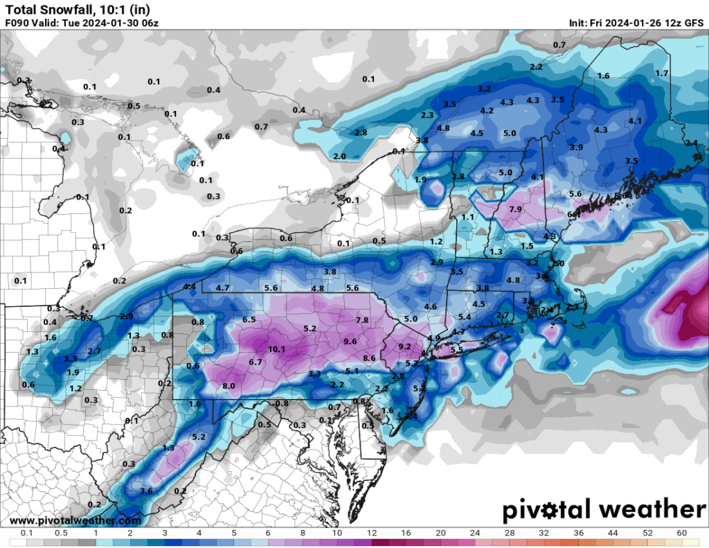
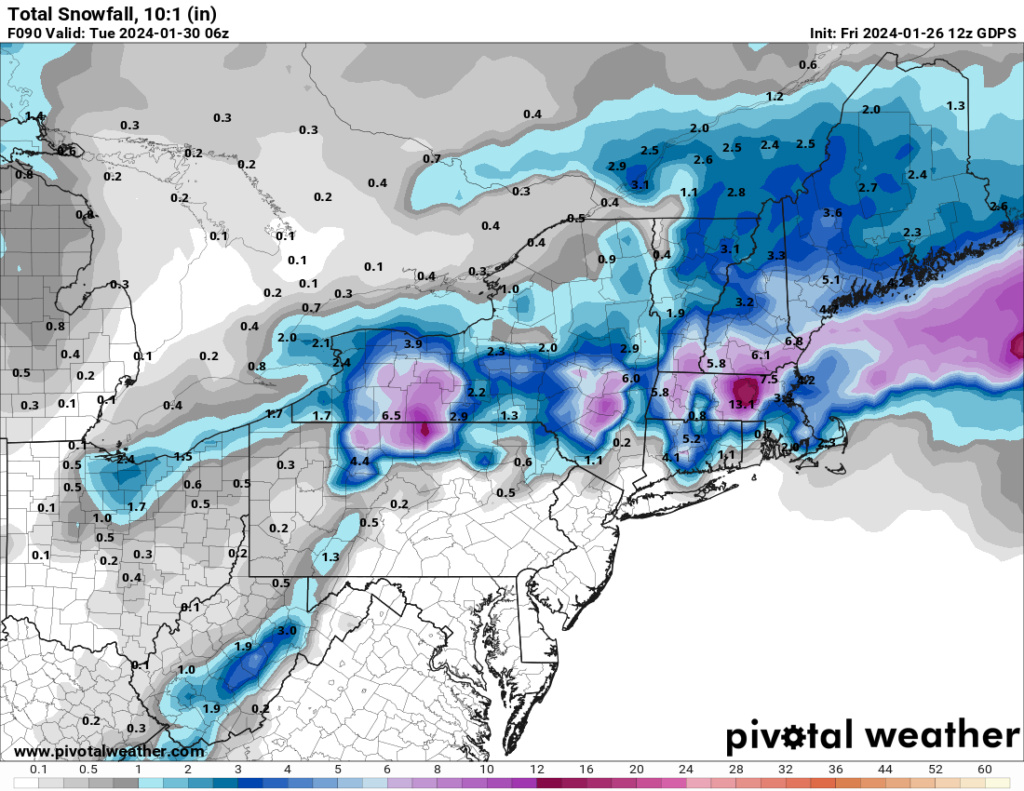
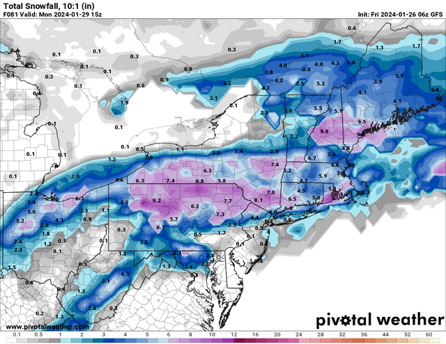
Here’s a look at what this mornings NAM and GFS are putting out in terms of snow. N&W is saved by a primary low that transfers to a secondary just off the coast of NJ. There’s enough forcing at 700mb to enable a steady snowfall that should deliver 3-6”. It’s a tricky forecast though. If the primary holds on any longer than currently modeled, you will also warm up your mid levels and find that snow accumulations get cut in half. The NAM in particular tries to get the snow down into NYC and LI, but I’m not buying it. It develops the secondary too far south for my liking. Outside of N&W, I think we’re looking at a cold and rainy Sunday. Pasta fagiol weather


 Re: JAN 28th-30th 2024 Potential system compliments of a +PNA
The H is going to be a day late and a dollar short IMO. Enough evidence to support that. Even so a better antecedent air mass and this would slam dunk 4-8" for the interior. It is what it is.
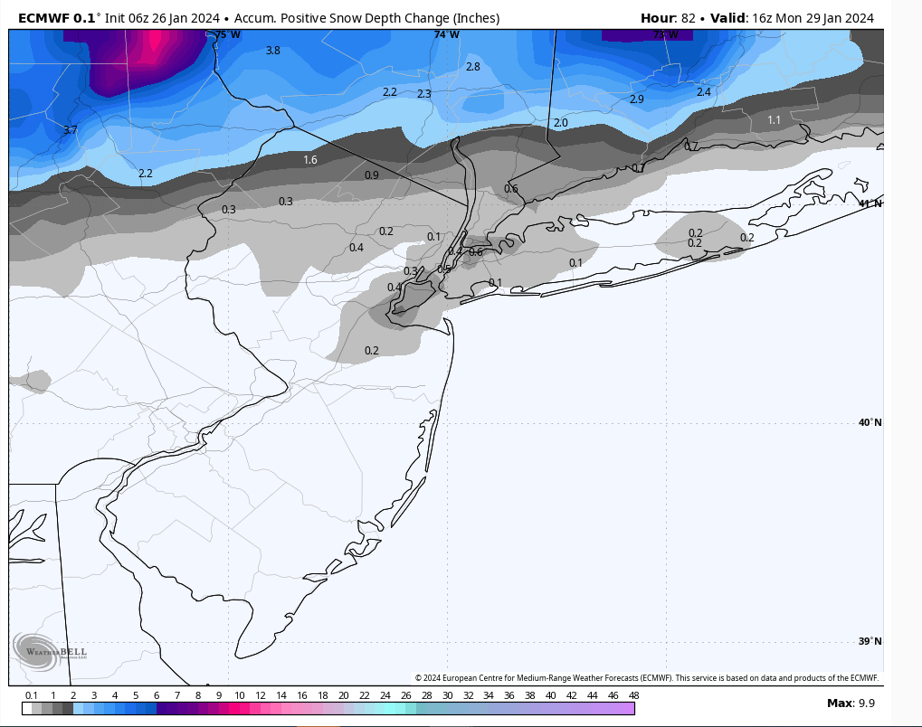
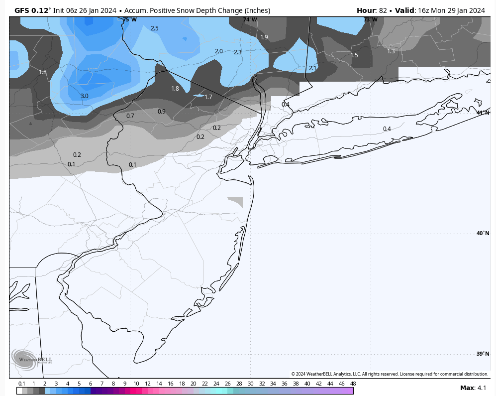
I like to use snow depth maps when the air mass is marginal. That being said I could see the most highly elevated areas of the interior > 1500' approach 3" with this and Catskills maybe approach 4"+. LHV Orange County an inch or two but towards Damian best shot at 2" with slightly higher elevation.
The rest of us I think we need to wait and there are signs of better fortunes as we approach February.
06Z Euro & GFS positive snow depth respectively


heehaw453- Advanced Forecaster

- Posts : 3906
Reputation : 86
Join date : 2014-01-20
Location : Bedminster Township, PA Elevation 600' ASL
 Re: JAN 28th-30th 2024 Potential system compliments of a +PNA
Frank_Wx wrote:Here’s a look at what this mornings NAM and GFS are putting out in terms of snow. N&W is saved by a primary low that transfers to a secondary just off the coast of NJ. There’s enough forcing at 700mb to enable a steady snowfall that should deliver 3-6”. It’s a tricky forecast though. If the primary holds on any longer than currently modeled, you will also warm up your mid levels and find that snow accumulations get cut in half. The NAM in particular tries to get the snow down into NYC and LI, but I’m not buying it. It develops the secondary too far south for my liking. Outside of N&W, I think we’re looking at a cold and rainy Sunday. Pasta fagiol weather
IMHO anyone looking at 10:1 snow maps of the NAM and hoping is going to be disappointed.
heehaw453- Advanced Forecaster

- Posts : 3906
Reputation : 86
Join date : 2014-01-20
Location : Bedminster Township, PA Elevation 600' ASL
moleson likes this post
 Re: JAN 28th-30th 2024 Potential system compliments of a +PNA
heehaw453 wrote:Frank_Wx wrote:Here’s a look at what this mornings NAM and GFS are putting out in terms of snow. N&W is saved by a primary low that transfers to a secondary just off the coast of NJ. There’s enough forcing at 700mb to enable a steady snowfall that should deliver 3-6”. It’s a tricky forecast though. If the primary holds on any longer than currently modeled, you will also warm up your mid levels and find that snow accumulations get cut in half. The NAM in particular tries to get the snow down into NYC and LI, but I’m not buying it. It develops the secondary too far south for my liking. Outside of N&W, I think we’re looking at a cold and rainy Sunday. Pasta fagiol weather
IMHO anyone looking at 10:1 snow maps of the NAM and hoping is going to be disappointed.
Its probably best to think this way but I wouldnt entirely discount the colder solns just yet, esp for off the immediate coast. Timing and positioning of the slp and the mid level energy will be key. A few hours off in reality or a shift of 25-30miles with any of it could be the diff between rain and 3-6" 48hrs out is a life time for those subtle changes.
_________________
"In weather and in life, there's no winning and losing; there's only winning and learning."
WINTER 2012/2013 TOTALS 43.65"WINTER 2017/2018 TOTALS 62.85" WINTER 2022/2023 TOTALS 4.9"
WINTER 2013/2014 TOTALS 64.85"WINTER 2018/2019 TOTALS 14.25" WINTER 2023/2024 TOTALS 13.1"
WINTER 2014/2015 TOTALS 71.20"WINTER 2019/2020 TOTALS 6.35"
WINTER 2015/2016 TOTALS 35.00"WINTER 2020/2021 TOTALS 37.75"
WINTER 2016/2017 TOTALS 42.25"WINTER 2021/2022 TOTALS 31.65"

sroc4- Admin

- Posts : 8354
Reputation : 302
Join date : 2013-01-07
Location : Wading River, LI
heehaw453- Advanced Forecaster

- Posts : 3906
Reputation : 86
Join date : 2014-01-20
Location : Bedminster Township, PA Elevation 600' ASL
weatherwatchermom likes this post

weatherwatchermom- Senior Enthusiast

- Posts : 3793
Reputation : 78
Join date : 2014-11-25
Location : Hazlet Township, NJ
heehaw453 and SENJsnowman like this post
 Re: JAN 28th-30th 2024 Potential system compliments of a +PNA
Coastal Plain says: We are present and ready!
SENJsnowman- Senior Enthusiast

- Posts : 1189
Reputation : 61
Join date : 2017-01-06
Age : 51
Location : Bayville, NJ
heehaw453 and weatherwatchermom like this post

aiannone- Senior Enthusiast - Mod

- Posts : 4815
Reputation : 92
Join date : 2013-01-07
Location : Saint James, LI (Northwest Suffolk Co.)

aiannone- Senior Enthusiast - Mod

- Posts : 4815
Reputation : 92
Join date : 2013-01-07
Location : Saint James, LI (Northwest Suffolk Co.)
SENJsnowman- Senior Enthusiast

- Posts : 1189
Reputation : 61
Join date : 2017-01-06
Age : 51
Location : Bayville, NJ
billg315 and Irish like this post
 Re: JAN 28th-30th 2024 Potential system compliments of a +PNA
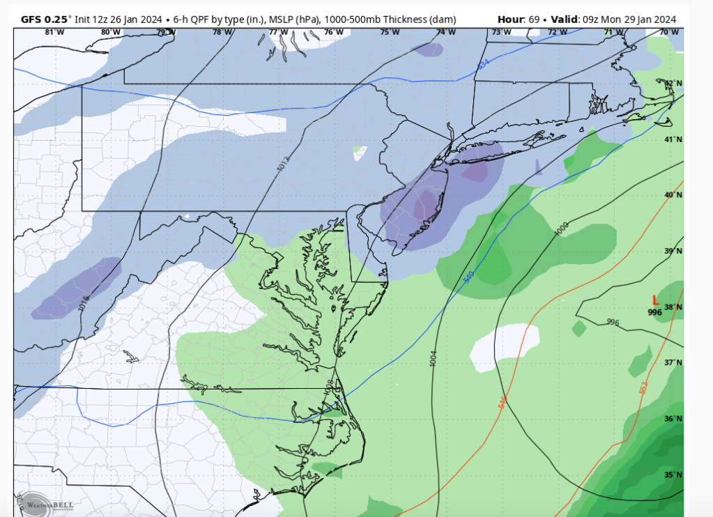
So us Coasties are sitting at the bar having a drink. Sitting across the bar from us is this gorgeos woman(12z GFS) flirting like crazy.

If we decide to get up and go over to talk to her there is a good chance as we apprach this guy will walk over and claim thats his girlfriend.

There is a chance we can take her home tonight if we play our cards just right, but the reality is this is who we are going home with.


If we decide to get up and go over to talk to her there is a good chance as we apprach this guy will walk over and claim thats his girlfriend.

There is a chance we can take her home tonight if we play our cards just right, but the reality is this is who we are going home with.

_________________
"In weather and in life, there's no winning and losing; there's only winning and learning."
WINTER 2012/2013 TOTALS 43.65"WINTER 2017/2018 TOTALS 62.85" WINTER 2022/2023 TOTALS 4.9"
WINTER 2013/2014 TOTALS 64.85"WINTER 2018/2019 TOTALS 14.25" WINTER 2023/2024 TOTALS 13.1"
WINTER 2014/2015 TOTALS 71.20"WINTER 2019/2020 TOTALS 6.35"
WINTER 2015/2016 TOTALS 35.00"WINTER 2020/2021 TOTALS 37.75"
WINTER 2016/2017 TOTALS 42.25"WINTER 2021/2022 TOTALS 31.65"

sroc4- Admin

- Posts : 8354
Reputation : 302
Join date : 2013-01-07
Location : Wading River, LI
Frank_Wx, docstox12, weatherwatchermom, billg315 and SENJsnowman like this post
 Re: JAN 28th-30th 2024 Potential system compliments of a +PNA
That’s cold Sroc. I mean that last person might be someone’s mother…
or father…
or father…
SENJsnowman- Senior Enthusiast

- Posts : 1189
Reputation : 61
Join date : 2017-01-06
Age : 51
Location : Bayville, NJ
heehaw453- Advanced Forecaster

- Posts : 3906
Reputation : 86
Join date : 2014-01-20
Location : Bedminster Township, PA Elevation 600' ASL
SENJsnowman likes this post

Grselig- Senior Enthusiast

- Posts : 1408
Reputation : 140
Join date : 2013-03-04
Age : 54
Location : Wayne NJ
sroc4, heehaw453 and JT33 like this post
heehaw453- Advanced Forecaster

- Posts : 3906
Reputation : 86
Join date : 2014-01-20
Location : Bedminster Township, PA Elevation 600' ASL
 Re: JAN 28th-30th 2024 Potential system compliments of a +PNA
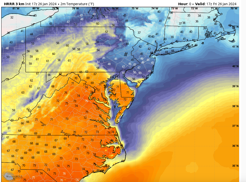
Yes I’m only at 43° in NE NJ!
MattyICE- Advanced Forecaster

- Posts : 249
Reputation : 6
Join date : 2017-11-10
Age : 38
Location : Clifton, NJ (Eastern Passaic County)
 Re: JAN 28th-30th 2024 Potential system compliments of a +PNA
Even the Jersey Shore is still only in the high 40’s. That warm from must of stalled out more south than expected.
heehaw, Would this have any bearing on Sunday/Monday?
heehaw, Would this have any bearing on Sunday/Monday?
SENJsnowman- Senior Enthusiast

- Posts : 1189
Reputation : 61
Join date : 2017-01-06
Age : 51
Location : Bayville, NJ
 Re: JAN 28th-30th 2024 Potential system compliments of a +PNA
SENJsnowman wrote:That’s cold Sroc. I mean that last person might be someone’s mother…
or father…
Im not saying we are taking home a bad person. Im just saying when it comes to attractiveness the reality is the GFS is the "supermodel" teasing you, but you have no shot. The reality of the outcome for the coast is we are going home with your homely looking, yet wonderful personality, mother...or father.
_________________
"In weather and in life, there's no winning and losing; there's only winning and learning."
WINTER 2012/2013 TOTALS 43.65"WINTER 2017/2018 TOTALS 62.85" WINTER 2022/2023 TOTALS 4.9"
WINTER 2013/2014 TOTALS 64.85"WINTER 2018/2019 TOTALS 14.25" WINTER 2023/2024 TOTALS 13.1"
WINTER 2014/2015 TOTALS 71.20"WINTER 2019/2020 TOTALS 6.35"
WINTER 2015/2016 TOTALS 35.00"WINTER 2020/2021 TOTALS 37.75"
WINTER 2016/2017 TOTALS 42.25"WINTER 2021/2022 TOTALS 31.65"

sroc4- Admin

- Posts : 8354
Reputation : 302
Join date : 2013-01-07
Location : Wading River, LI
weatherwatchermom, billg315 and MattyICE like this post
 Re: JAN 28th-30th 2024 Potential system compliments of a +PNA
SENJsnowman wrote:Even the Jersey Shore is still only in the high 40’s. That warm from must of stalled out more south than expected.
heehaw, Would this have any bearing on Sunday/Monday?
IMO no. For your area it will come down to if the storm deepens fast enough as it pushes off the coast. You want that H in Quebec to press more and be more robust coupled with a neutral h5 through to consolidate the storm's mid-levels. No chance for coastal plain with the initial moisture feed. It's only the coastal that gives some slim shot IMO. Again this one slim shot, but give it a week from now and things might start getting more interesting for the coastal plain...
heehaw453- Advanced Forecaster

- Posts : 3906
Reputation : 86
Join date : 2014-01-20
Location : Bedminster Township, PA Elevation 600' ASL
sroc4 and SENJsnowman like this post
 Re: JAN 28th-30th 2024 Potential system compliments of a +PNA
sroc4 wrote:SENJsnowman wrote:That’s cold Sroc. I mean that last person might be someone’s mother…
or father…
Im not saying we are taking home a bad person. Im just saying when it comes to attractiveness the reality is the GFS is the "supermodel" teasing you, but you have no shot. The reality of the outcome for the coast is we are going home with your homely looking, yet wonderful personality, mother...or father.
Sroc my man, it sounds like you missed my joke. As in, she so damn ugly, is that a woman or a man, I can’t tell. But like they say, if you have to explain your joke, the joke failed.
HeeHaw, since I moved to Jersey in 2012, March snowfall has far surpassed February in coastal Ocean and Monmouth counties. I can’t think of a single memorable Feb snowfall for these parts and that includes Feb ‘21. Would LOVE to change that script this year!
SENJsnowman- Senior Enthusiast

- Posts : 1189
Reputation : 61
Join date : 2017-01-06
Age : 51
Location : Bayville, NJ
Irish likes this post
 Re: JAN 28th-30th 2024 Potential system compliments of a +PNA
SENJsnowman wrote:sroc4 wrote:SENJsnowman wrote:That’s cold Sroc. I mean that last person might be someone’s mother…
or father…
Im not saying we are taking home a bad person. Im just saying when it comes to attractiveness the reality is the GFS is the "supermodel" teasing you, but you have no shot. The reality of the outcome for the coast is we are going home with your homely looking, yet wonderful personality, mother...or father.
Sroc my man, it sounds like you missed my joke. As in, she so damn ugly, is that a woman or a man, I can’t tell. But like they say, if you have to explain your joke, the joke failed.
HeeHaw, since I moved to Jersey in 2012, March snowfall has far surpassed February in coastal Ocean and Monmouth counties. I can’t think of a single memorable Feb snowfall for these parts and that includes Feb ‘21. Would LOVE to change that script this year!
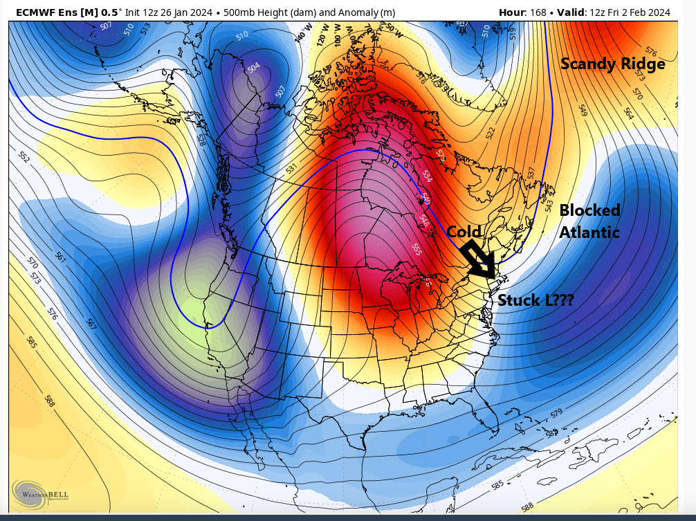
I'm amazed that. March normally is interior for bigger stuff. I wouldn't be surprised if starting next Friday things could be interesting.
heehaw453- Advanced Forecaster

- Posts : 3906
Reputation : 86
Join date : 2014-01-20
Location : Bedminster Township, PA Elevation 600' ASL
 Re: JAN 28th-30th 2024 Potential system compliments of a +PNA
Any chance the colder than expected temperatures we’re having today possibly being a sign that colder air may push down further south than modeled come this Sunday?
richb521- Posts : 61
Reputation : 3
Join date : 2014-01-19
Age : 50
Location : Hillsborough, NJ
 Re: JAN 28th-30th 2024 Potential system compliments of a +PNA
richb521 wrote:Any chance the colder than expected temperatures we’re having today possibly being a sign that colder air may push down further south than modeled come this Sunday?
There is always a chance Rich. We all likely start as rain. You may be just far enough ff the coast to be ok once the secondary low is established and deepens. My concern though is that the precip may be gone for you by then. In the words of the great Yogi Berra "It aint ova till its ova"
_________________
"In weather and in life, there's no winning and losing; there's only winning and learning."
WINTER 2012/2013 TOTALS 43.65"WINTER 2017/2018 TOTALS 62.85" WINTER 2022/2023 TOTALS 4.9"
WINTER 2013/2014 TOTALS 64.85"WINTER 2018/2019 TOTALS 14.25" WINTER 2023/2024 TOTALS 13.1"
WINTER 2014/2015 TOTALS 71.20"WINTER 2019/2020 TOTALS 6.35"
WINTER 2015/2016 TOTALS 35.00"WINTER 2020/2021 TOTALS 37.75"
WINTER 2016/2017 TOTALS 42.25"WINTER 2021/2022 TOTALS 31.65"

sroc4- Admin

- Posts : 8354
Reputation : 302
Join date : 2013-01-07
Location : Wading River, LI
richb521 likes this post
 Re: JAN 28th-30th 2024 Potential system compliments of a +PNA
SENJsnowman wrote:sroc4 wrote:SENJsnowman wrote:That’s cold Sroc. I mean that last person might be someone’s mother…
or father…
Im not saying we are taking home a bad person. Im just saying when it comes to attractiveness the reality is the GFS is the "supermodel" teasing you, but you have no shot. The reality of the outcome for the coast is we are going home with your homely looking, yet wonderful personality, mother...or father.
Sroc my man, it sounds like you missed my joke. As in, she so damn ugly, is that a woman or a man, I can’t tell. But like they say, if you have to explain your joke, the joke failed.
HeeHaw, since I moved to Jersey in 2012, March snowfall has far surpassed February in coastal Ocean and Monmouth counties. I can’t think of a single memorable Feb snowfall for these parts and that includes Feb ‘21. Would LOVE to change that script this year!
LOL Its all good. Text messages and chat boards...you def lose some of the flavor of the true context in some of the conversations. My bad
_________________
"In weather and in life, there's no winning and losing; there's only winning and learning."
WINTER 2012/2013 TOTALS 43.65"WINTER 2017/2018 TOTALS 62.85" WINTER 2022/2023 TOTALS 4.9"
WINTER 2013/2014 TOTALS 64.85"WINTER 2018/2019 TOTALS 14.25" WINTER 2023/2024 TOTALS 13.1"
WINTER 2014/2015 TOTALS 71.20"WINTER 2019/2020 TOTALS 6.35"
WINTER 2015/2016 TOTALS 35.00"WINTER 2020/2021 TOTALS 37.75"
WINTER 2016/2017 TOTALS 42.25"WINTER 2021/2022 TOTALS 31.65"

sroc4- Admin

- Posts : 8354
Reputation : 302
Join date : 2013-01-07
Location : Wading River, LI
SENJsnowman likes this post
 Re: JAN 28th-30th 2024 Potential system compliments of a +PNA
Yes some of the more aggressive forecasts for this end of week warm-up were overdone. Only got up to about 49* here today and it was a raw/chilly 49*. Earlier this week some forecasts had me in the upper 50s today. Probably doesn't mean much for Sunday though. As pointed out above by heehaw and scott this really depends on the storm intensifying enough to pull in and create it's own cold air source. Except areas N and W where I think the chances of some accumulating snow are pretty decent regardless.

billg315- Advanced Forecaster - Mod

- Posts : 4483
Reputation : 185
Join date : 2015-01-24
Age : 50
Location : Flemington, NJ
amugs likes this post
 Re: JAN 28th-30th 2024 Potential system compliments of a +PNA
Earlier this week I had co workers saying to me at lunch, it's going to be 60 Friday and a nice weekend and I said I don't buy it this Thaw is short lived. Look at next week's temps are tye storm?
And the storm is too early as said above, whenever you move up 24hrs a storm will inevitably fail somehow. IF this came in as pronged 2 days ago Sunday night into Modday Monday, tye HP has time to then get in place and sag a bit S, now it'll feel that LP primary and back off s bit. Paths of least resistance in weather n nature. Time will tell but 18Z GFS is at the bar looking at the shanty SROC pictured above still holds onto to a decent snow until it wakes up and shift 75 miles NW.
Shame......again.
End of the week has a wild set up IF true but that'll change of course.
_________________
Mugs
AKA:King: Snow Weenie
Self Proclaimed
WINTER 2014-15 : 55.12" +.02 for 6 coatings (avg. 35")
WINTER 2015-16 Total - 29.8" (Avg 35")
WINTER 2016-17 : 39.5" so far

amugs- Advanced Forecaster - Mod

- Posts : 15095
Reputation : 213
Join date : 2013-01-07
Age : 54
Location : Hillsdale,NJ
sroc4 likes this post
Page 3 of 5 •  1, 2, 3, 4, 5
Permissions in this forum:
You cannot reply to topics in this forum|
|
|

 Home
Home
