Long Range Thread 28.0
+33
weatherwatchermom
essexcountypete
skinsfan1177
aiannone
larryrock72
Coachgriff
DAYBLAZER
nutleyblizzard
hyde345
docstox12
CPcantmeasuresnow
frank 638
Koroptim
HectorO
billg315
dkodgis
MattyICE
toople
sroc4
rb924119
Grselig
crippo84
phil155
Frank_Wx
jmanley32
NJBear
tomsriversnowstorm
Carvin
heehaw453
SENJsnowman
Irish
amugs
richb521
37 posters
Page 1 of 18
Page 1 of 18 • 1, 2, 3 ... 9 ... 18 
 Long Range Thread 28.0
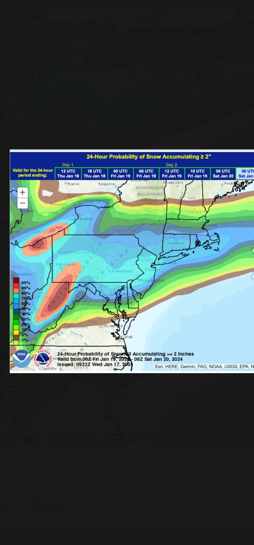
Is there going to be more back and forth on the models like the windshield wiper effect for this Friday’s storm? Or is now typically the time the last wipe (trend) is crossing the window so to speak?
richb521- Posts : 61
Reputation : 3
Join date : 2014-01-19
Age : 50
Location : Hillsborough, NJ
 Re: Long Range Thread 28.0
NW trends are inevitable this winter.
_________________
Mugs
AKA:King: Snow Weenie
Self Proclaimed
WINTER 2014-15 : 55.12" +.02 for 6 coatings (avg. 35")
WINTER 2015-16 Total - 29.8" (Avg 35")
WINTER 2016-17 : 39.5" so far

amugs- Advanced Forecaster - Mod

- Posts : 15095
Reputation : 213
Join date : 2013-01-07
Age : 54
Location : Hillsdale,NJ
 Re: Long Range Thread 28.0
True, but I've read elsewhere that this could be a more Southern event, not up into New England.amugs wrote:NW trends are inevitable this winter.

Irish- Pro Enthusiast

- Posts : 788
Reputation : 19
Join date : 2019-01-16
Age : 45
Location : Old Bridge, NJ
 Re: Long Range Thread 28.0
Irish wrote:True, but I've read elsewhere that this could be a more Southern event, not up into New England.amugs wrote:NW trends are inevitable this winter.
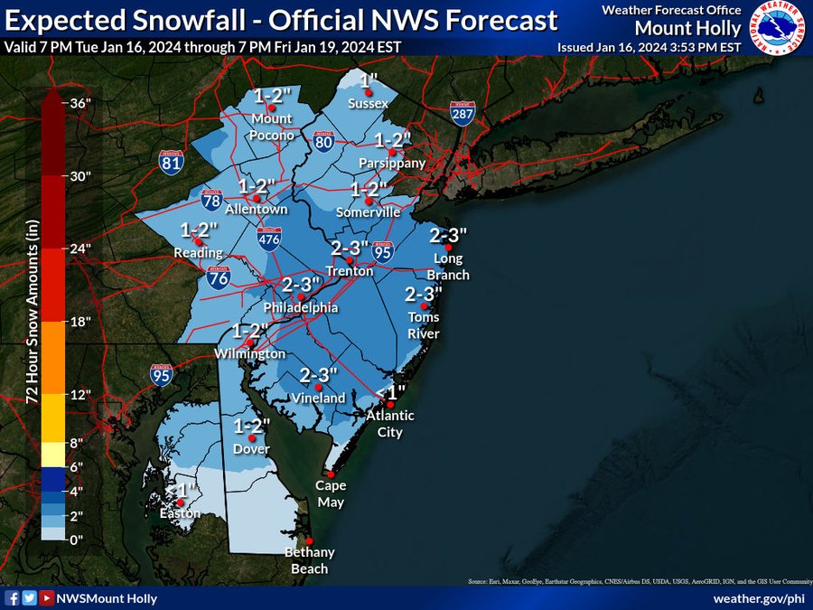
Oh yes and look at the last 3 runs - it was northern fringe into Driscoll Bridge now its snowing up to Albany
Holly is on it already wow!
_________________
Mugs
AKA:King: Snow Weenie
Self Proclaimed
WINTER 2014-15 : 55.12" +.02 for 6 coatings (avg. 35")
WINTER 2015-16 Total - 29.8" (Avg 35")
WINTER 2016-17 : 39.5" so far

amugs- Advanced Forecaster - Mod

- Posts : 15095
Reputation : 213
Join date : 2013-01-07
Age : 54
Location : Hillsdale,NJ
Irish likes this post
 Re: Long Range Thread 28.0
A major #SSW looks likely to occur tomorrow- check out the new blog post about it! https://t.co/Tf0EFRA9Xc
— Dr. Amy H Butler (@DrAHButler) January 16, 2024
February effects incoming....hopefully!!
_________________
Mugs
AKA:King: Snow Weenie
Self Proclaimed
WINTER 2014-15 : 55.12" +.02 for 6 coatings (avg. 35")
WINTER 2015-16 Total - 29.8" (Avg 35")
WINTER 2016-17 : 39.5" so far

amugs- Advanced Forecaster - Mod

- Posts : 15095
Reputation : 213
Join date : 2013-01-07
Age : 54
Location : Hillsdale,NJ
SENJsnowman likes this post
 Re: Long Range Thread 28.0
richb521 wrote:Is there going to be more back and forth on the models like the windshield wiper effect for this Friday’s storm? Or is now typically the time the last wipe (trend) is crossing the window so to speak?
It seems that every snowstorm we get (and also the ones we don’t get) has major forecast fluctuations up until the end. The only time I remember all the models getting locked in even 3 days out was Jan 2015, and we don’t like to talk about that ‘storm’.
So, if we’re lucky the wild ride is just getting started.
SENJsnowman- Senior Enthusiast

- Posts : 1189
Reputation : 61
Join date : 2017-01-06
Age : 51
Location : Bayville, NJ
richb521 likes this post
 Re: Long Range Thread 28.0
I've been talking about this trough digging and consolidation, but as important IMO is the wave separation from the departing ULL (today's storm). The Canadian is separating the departing storm a bit more than the other guidance (Euro/GFS). Storms need room to breathe so to speak and too close together really limits development. We have to see how that trends, but if it's too close this will have a hard ceiling.
12Z Canadian (more impact)
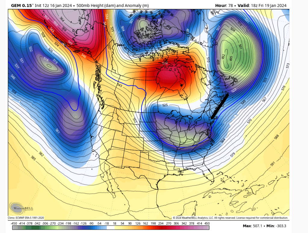
12Z Euro (less impact)
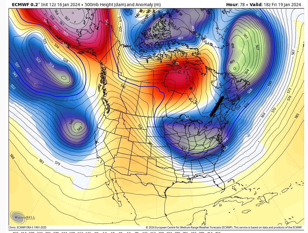
12Z Canadian (more impact)

12Z Euro (less impact)

heehaw453- Advanced Forecaster

- Posts : 3906
Reputation : 86
Join date : 2014-01-20
Location : Bedminster Township, PA Elevation 600' ASL
 Re: Long Range Thread 28.0
This storm is the best chance this year not a will it it or won’t it it’s just how much and it can be 1 or it can be around 15 nyc
Carvin- Posts : 44
Reputation : 2
Join date : 2019-01-09
phil155 and silentwreck like this post
 Re: Long Range Thread 28.0
So serious question. I am excited that we will get an inch or 2 on Friday. However mid next week looks real warm. So is February setting up to be a warm month or is next week an outlier
tomsriversnowstorm- Posts : 90
Reputation : 0
Join date : 2021-02-06
 Re: Long Range Thread 28.0
Frank commented earlier that after Friday's storm, we will warm up again for the following 10+ days, closing out January. However, once February arrives, we should be game on tracking again.tomsriversnowstorm wrote:So serious question. I am excited that we will get an inch or 2 on Friday. However mid next week looks real warm. So is February setting up to be a warm month or is next week an outlier

Irish- Pro Enthusiast

- Posts : 788
Reputation : 19
Join date : 2019-01-16
Age : 45
Location : Old Bridge, NJ
sroc4 likes this post
 Re: Long Range Thread 28.0
Sounds good thank you
quote="Irish"]
quote="Irish"]
Frank commented earlier that after Friday's storm, we will warm up again for the following 10+ days, closing out January. However, once February arrives, we should be game on tracking again.[/quote]tomsriversnowstorm wrote:So serious question. I am excited that we will get an inch or 2 on Friday. However mid next week looks real warm. So is February setting up to be a warm month or is next week an outlier
tomsriversnowstorm- Posts : 90
Reputation : 0
Join date : 2021-02-06
Irish likes this post
 Re: Long Range Thread 28.0
tomsriversnowstorm wrote:So serious question. I am excited that we will get an inch or 2 on Friday. However mid next week looks real warm. So is February setting up to be a warm month or is next week an outlier
Next week is the typical Jan thaw after an arctic wellndouble arctic outbreak
_________________
Mugs
AKA:King: Snow Weenie
Self Proclaimed
WINTER 2014-15 : 55.12" +.02 for 6 coatings (avg. 35")
WINTER 2015-16 Total - 29.8" (Avg 35")
WINTER 2016-17 : 39.5" so far

amugs- Advanced Forecaster - Mod

- Posts : 15095
Reputation : 213
Join date : 2013-01-07
Age : 54
Location : Hillsdale,NJ
 Re: Long Range Thread 28.0
tomsriversnowstorm wrote:So serious question. I am excited that we will get an inch or 2 on Friday. However mid next week looks real warm. So is February setting up to be a warm month or is next week an outlier
Seems we may be heading into a favorable Pacific pattern (-EPO/+PNA). Probably been since 2014-15 had any consistency with that. Tends to be colder than normal with snowfall chances initially smaller events. Once you get a 50/50 Low in that setup then it can produce big ticket items. It's going to take a big ticket item IMO for most on this board to get anywhere close to normal snowfall this season.
heehaw453- Advanced Forecaster

- Posts : 3906
Reputation : 86
Join date : 2014-01-20
Location : Bedminster Township, PA Elevation 600' ASL
 Re: Long Range Thread 28.0
Irish wrote:
Might as well. Something is brewing. The weather doesn't know that we started thread, it's gonna do what it's gonna do.
Are you sure? -cue spooky music- I mean how does the weather KNOW where I-95 and I-78 are?

NJBear- Posts : 28
Reputation : 0
Join date : 2024-01-06
kalleg, nancy-j-s, essexcountypete, dkodgis and Irish like this post
 Re: Long Range Thread 28.0
Anyone know if rb is okay? I just realized I did not see him for this storm nor the cutter, hope he is okay. I would think he would be posting his analysis.

jmanley32- Senior Enthusiast

- Posts : 20535
Reputation : 108
Join date : 2013-12-12
Age : 43
Location : Yonkers, NY
 Re: Long Range Thread 28.0
Great question. Maybe he's just choosing to sit out. I know he made some comment about being off on recent predictions. Maybe he's taking a break.jmanley32 wrote:Anyone know if rb is okay? I just realized I did not see him for this storm nor the cutter, hope he is okay. I would think he would be posting his analysis.

Irish- Pro Enthusiast

- Posts : 788
Reputation : 19
Join date : 2019-01-16
Age : 45
Location : Old Bridge, NJ
 Re: Long Range Thread 28.0
If thats the case rb get your butt in here!! Your analysis and forcasting are excellent, so what if they may niot have verified 100%. We need your play by play brotha!Irish wrote:Great question. Maybe he's just choosing to sit out. I know he made some comment about being off on recent predictions. Maybe he's taking a break.jmanley32 wrote:Anyone know if rb is okay? I just realized I did not see him for this storm nor the cutter, hope he is okay. I would think he would be posting his analysis.

jmanley32- Senior Enthusiast

- Posts : 20535
Reputation : 108
Join date : 2013-12-12
Age : 43
Location : Yonkers, NY
Irish likes this post
 Re: Long Range Thread 28.0
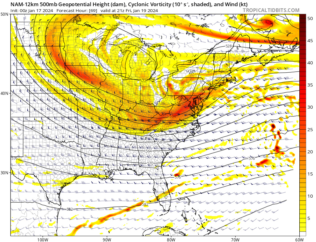
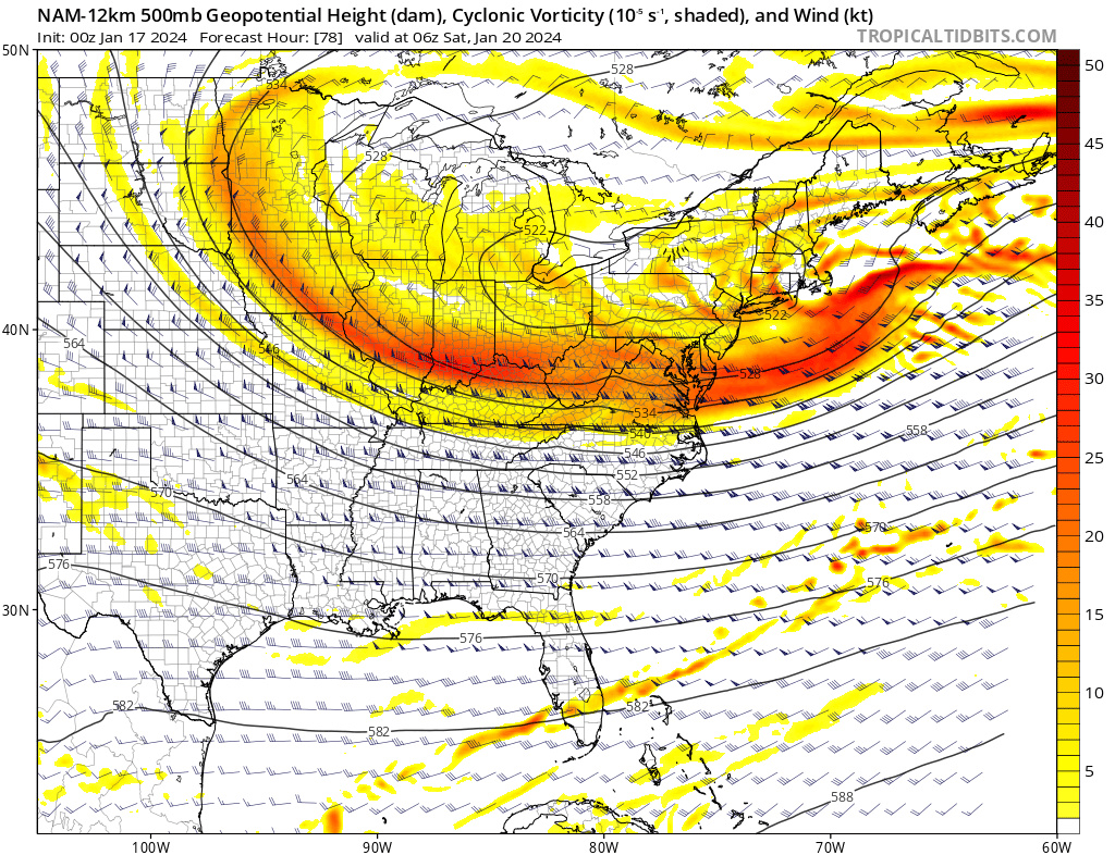
The NAM tonight closed H5 over the Great Lakes on Friday afternoon and the trough became neutral as H5 remained closed. We need the ULL south of our area and for the trough to be neutral-negative as it swings off the coast. This spawns surface low in an ideal location. We keep seeing these very small improvements at the 500mb level. BIG day of model runs tomorrow. Regardless, there will be an IVT trough and since temps are cold, we’re likely looking at a minimum high ratio 1-3” snowfall type.


_________________
_______________________________________________________________________________________________________
CLICK HERE to view NJ Strong Snowstorm Classifications
docstox12, nancy-j-s, essexcountypete, 1190ftalt and Irish like this post
 Re: Long Range Thread 28.0
We can take that and hope for more. Looking forward to tomorrow!Frank_Wx wrote:The NAM tonight closed H5 over the Great Lakes on Friday afternoon and the trough became neutral as H5 remained closed. We need the ULL south of our area and for the trough to be neutral-negative as it swings off the coast. This spawns surface low in an ideal location. We keep seeing these very small improvements at the 500mb level. BIG day of model runs tomorrow. Regardless, there will be an IVT trough and since temps are cold, we’re likely looking at a minimum high ratio 1-3” snowfall type.

Irish- Pro Enthusiast

- Posts : 788
Reputation : 19
Join date : 2019-01-16
Age : 45
Location : Old Bridge, NJ
nancy-j-s and SENJsnowman like this post
 Re: Long Range Thread 28.0
Looked to me that at 06z the NAM and the RGEM both show a bit more of a robust system than the other models. But they still were in 1-3” range generally with an add’l inch or two across central and southern Jersey. Definitely shows the potential to get a bigger final result, but one definition of potential is “hasn’t done it yet.”
Today is a big tracking day…sorry boss!! I’ll pick up the pace again next week! But today, we track!
Today is a big tracking day…sorry boss!! I’ll pick up the pace again next week! But today, we track!

SENJsnowman- Senior Enthusiast

- Posts : 1189
Reputation : 61
Join date : 2017-01-06
Age : 51
Location : Bayville, NJ
 Re: Long Range Thread 28.0
SENJsnowman wrote:Looked to me that at 06z the NAM and the RGEM both show a bit more of a robust system than the other models. But they still were in 1-3” range generally with an add’l two across central and southern Jersey. Definitely shows the potential to get a bigger final result, but one definition of potential is “hasn’t done it yet.”
Today is a big tracking day…sorry boss!! I’ll pick up the pace again next week! But today, I track!
A little earlier today on news12 I heard them mention a 2-4 ot 3-6 type system for Friday. We will see and we track
phil155- Pro Enthusiast

- Posts : 483
Reputation : 4
Join date : 2019-12-16
SENJsnowman likes this post

Irish- Pro Enthusiast

- Posts : 788
Reputation : 19
Join date : 2019-01-16
Age : 45
Location : Old Bridge, NJ

Irish- Pro Enthusiast

- Posts : 788
Reputation : 19
Join date : 2019-01-16
Age : 45
Location : Old Bridge, NJ
SENJsnowman likes this post
heehaw453- Advanced Forecaster

- Posts : 3906
Reputation : 86
Join date : 2014-01-20
Location : Bedminster Township, PA Elevation 600' ASL
 Re: Long Range Thread 28.0
SENJsnowman wrote:Looked to me that at 06z the NAM and the RGEM both show a bit more of a robust system than the other models. But they still were in 1-3” range generally with an add’l inch or two across central and southern Jersey. Definitely shows the potential to get a bigger final result, but one definition of potential is “hasn’t done it yet.”
Today is a big tracking day…sorry boss!! I’ll pick up the pace again next week! But today, we track!
You have an ULL sliding underneath the area. That in and of itself can cause surprises if it can close off before hitting coasty. Seen is way too many times over the years especially with a bottlenecked Atlantic. I think though 1-3" is an excellent expectations setter for now.
heehaw453- Advanced Forecaster

- Posts : 3906
Reputation : 86
Join date : 2014-01-20
Location : Bedminster Township, PA Elevation 600' ASL
SENJsnowman likes this post
Page 1 of 18 • 1, 2, 3 ... 9 ... 18 
Page 1 of 18
Permissions in this forum:
You cannot reply to topics in this forum|
|
|

 Home
Home

