
 Search
1/29 - 1/30, 2014 Possible Snowstorm
Page 1 of 4 • 1, 2, 3, 4 ![]()

1/29 - 1/30, 2014 Possible Snowstorm
![]() by Frank_Wx Sun Jan 26, 2014 9:12 pm
by Frank_Wx Sun Jan 26, 2014 9:12 pm
It's not over.
Here was the 00z GFS H5 map from LAST NIGHT

In comparison, here is the latest 18z GFS H5 map
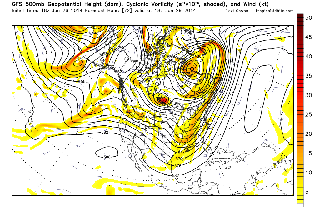
Notice 3 important things:
1. There is a little more ridging in the west, not as zonal.
2. The kicker is still there, but it's holding back more.
3. More STJ energy involved helping to tilt the trough favorably.
Let's see if this trends continues. Remain cautious though, I still think a lot more needs to happen and am leaning against a storm for midweek.
_________________
_______________________________________________________________________________________________________
CLICK HERE to view NJ Strong Snowstorm Classifications

Frank_Wx- Godzilla Seeker

- Posts : 21305
Reputation : 328
Join date : 2013-01-05
Age : 32
Location : Jersey City, NJ -

Re: 1/29 - 1/30, 2014 Possible Snowstorm
![]() by NjWeatherGuy Sun Jan 26, 2014 9:33 pm
by NjWeatherGuy Sun Jan 26, 2014 9:33 pm

NjWeatherGuy- Advanced Forecaster

- Posts : 4100
Reputation : 28
Join date : 2013-01-06
Location : Belle Mead, NJ
Re: 1/29 - 1/30, 2014 Possible Snowstorm
![]() by Frank_Wx Sun Jan 26, 2014 9:34 pm
by Frank_Wx Sun Jan 26, 2014 9:34 pm
NjWeatherGuy wrote:I was about to make a post about this, then I realized you already did. Although this thing still is a stretch for our area, it's continued trending NW to involve the southeast coast with snow at this point with a good 3+ days to continue trending, it's become something to watch. Overall I am still strongly against this storm for our area, however ATM I believe that somebody on the east coast is going to get a good amount of snow from this.
Carolina's and Virginia could really see a nice snowstorm out of this
_________________
_______________________________________________________________________________________________________
CLICK HERE to view NJ Strong Snowstorm Classifications
Frank_Wx- Godzilla Seeker
- Posts : 21305
Reputation : 328
Join date : 2013-01-05
Age : 32
Location : Jersey City, NJ -
Re: 1/29 - 1/30, 2014 Possible Snowstorm
![]() by NjWeatherGuy Sun Jan 26, 2014 9:44 pm
by NjWeatherGuy Sun Jan 26, 2014 9:44 pm
http://www.raymondcmartinjr.com/weather/2006/12-Feb-06-SeaLevelPressure.html
Problem is the trough in this case is very positively tilted and the weak storm goes out to sea. However, if by some way, it trends stronger and the jets phase it could come up the coast as the trough becomes neutral to negatively tilted. An unlikely thing to happen but theoretically speaking...
NjWeatherGuy- Advanced Forecaster
- Posts : 4100
Reputation : 28
Join date : 2013-01-06
Location : Belle Mead, NJ
Re: 1/29 - 1/30, 2014 Possible Snowstorm
![]() by NjWeatherGuy Sun Jan 26, 2014 9:58 pm
by NjWeatherGuy Sun Jan 26, 2014 9:58 pm
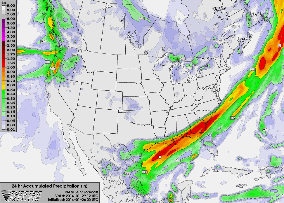
0z NAM (tonight) 24 hour QPF hour 60
NjWeatherGuy- Advanced Forecaster
- Posts : 4100
Reputation : 28
Join date : 2013-01-06
Location : Belle Mead, NJ
Re: 1/29 - 1/30, 2014 Possible Snowstorm
![]() by jmanley32 Sun Jan 26, 2014 10:02 pm
by jmanley32 Sun Jan 26, 2014 10:02 pm

jmanley32- Senior Enthusiast

- Posts : 20535
Reputation : 108
Join date : 2013-12-12
Age : 43
Location : Yonkers, NY
Re: 1/29 - 1/30, 2014 Possible Snowstorm
![]() by Frank_Wx Sun Jan 26, 2014 10:50 pm
by Frank_Wx Sun Jan 26, 2014 10:50 pm
_________________
_______________________________________________________________________________________________________
CLICK HERE to view NJ Strong Snowstorm Classifications
Frank_Wx- Godzilla Seeker
- Posts : 21305
Reputation : 328
Join date : 2013-01-05
Age : 32
Location : Jersey City, NJ -
Re: 1/29 - 1/30, 2014 Possible Snowstorm
![]() by aiannone Sun Jan 26, 2014 10:51 pm
by aiannone Sun Jan 26, 2014 10:51 pm
_________________
-Alex Iannone-

aiannone- Senior Enthusiast - Mod

- Posts : 4815
Reputation : 92
Join date : 2013-01-07
Location : Saint James, LI (Northwest Suffolk Co.)
Re: 1/29 - 1/30, 2014 Possible Snowstorm
![]() by jmanley32 Sun Jan 26, 2014 11:22 pm
by jmanley32 Sun Jan 26, 2014 11:22 pm
jmanley32- Senior Enthusiast
- Posts : 20535
Reputation : 108
Join date : 2013-12-12
Age : 43
Location : Yonkers, NY
Re: 1/29 - 1/30, 2014 Possible Snowstorm
![]() by Nyi1058 Sun Jan 26, 2014 11:37 pm
by Nyi1058 Sun Jan 26, 2014 11:37 pm
Nyi1058- Posts : 86
Reputation : 3
Join date : 2013-12-04
Age : 49
Location : Port Jefferson Long Island
Re: 1/29 - 1/30, 2014 Possible Snowstorm
![]() by jmanley32 Sun Jan 26, 2014 11:47 pm
by jmanley32 Sun Jan 26, 2014 11:47 pm
jmanley32- Senior Enthusiast
- Posts : 20535
Reputation : 108
Join date : 2013-12-12
Age : 43
Location : Yonkers, NY
Re: 1/29 - 1/30, 2014 Possible Snowstorm
![]() by algae888 Mon Jan 27, 2014 4:23 am
by algae888 Mon Jan 27, 2014 4:23 am
POSITIVELY TILTED SHORTWAVE MOVES OFF THE EAST COAST TUESDAY NIGHT
INTO WEDNESDAY. AT LEAST THAT`S WHAT ONE WOULD SAY BY LOOKING AT
DETERMINISTIC MODEL RUNS. THE SREF AND GEFS REVEAL THE POTENTIAL
FOR A SHARPER LESS PROGRESSIVE NEUTRALLY TILTED TROF.
ALL 00Z DETERMINISTIC MODELS...KEEP THE DEVELOPING LOW PRESSURE AREA
WELL SOUTH AND EAST OF THE REGION. THE PCPN SHIELD THOUGH IS VERY
CLOSE THOUGH IN THE CANADIAN...GFS AND ECMWF CLIPPING THE SOUTH FORK
OF LONG ISLAND OVERNIGHT TUESDAY. THE NAM IS WELL SOUTH. THE 21Z AND
03Z SREF IS SIMILAR IN THIS THINKING. THE 21Z HAD SEVERAL MEMBERS
THAT HAVE A MUCH SLOWER SURFACE DEVELOPMENT DUE TO SLOWING DOWN AND
SHARPENING OF THE UPPER TROF OVER THE OHIO VALLEY ON WEDNESDAY.
WHILE THE 03Z APPEARS TO BE TRENDING DOWN FROM THIS BASED ON PLUME
ANALYSIS. THE SHORTWAVE OF CONCERN IS NOW COMING INTO
SASKATCHEWAN/ALBERTA.
EXAMINATION OF THE 00Z GEFS ALSO SHOWS SOME MEMBERS WITH THIS IDEA
AS WELL. BASED ON THIS...SLIGHT CHC POPS ARE BEING ADDED TO THE WED
FORECAST. WILL CALL IS LIGHT SN...BUT NOTED THE 21Z SREF PLUMES HAD
TWO MEMBERS OVER 6 INCHES AND ABOUT 50% WITH MEASURABLE...LESS
MEMBERS NOW THOUGH IN THE 03Z RUN.
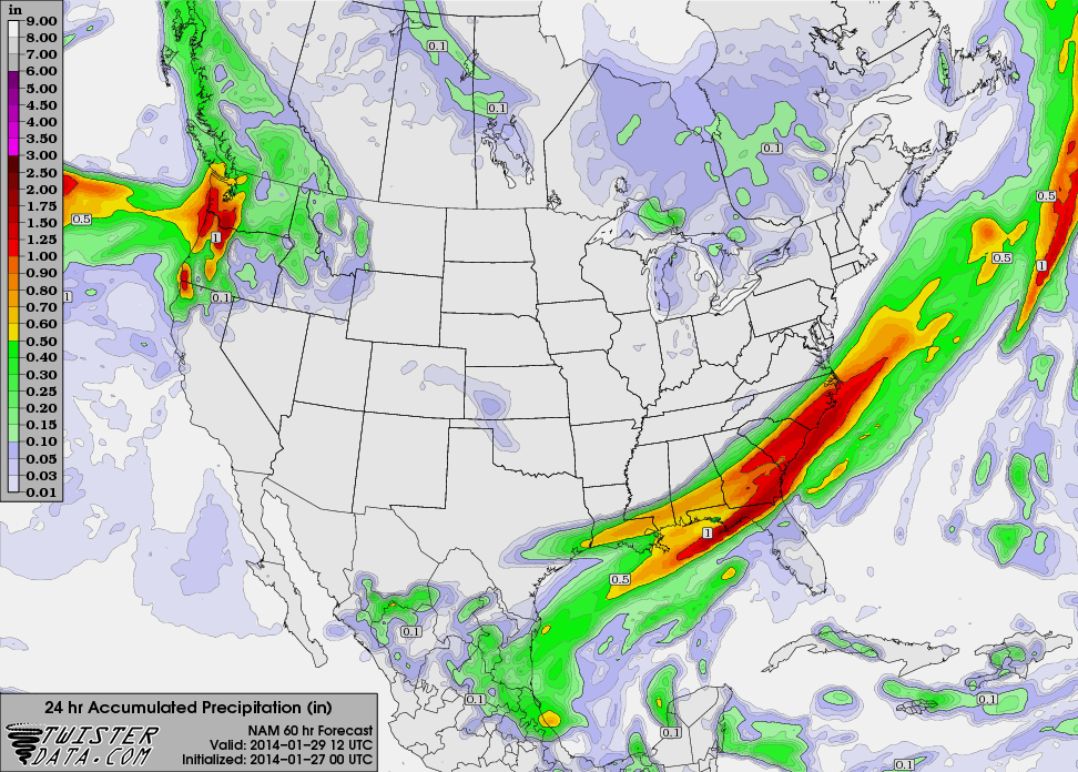
6z NAM ots

algae888- Advanced Forecaster
- Posts : 5311
Reputation : 46
Join date : 2013-02-05
Age : 62
Location : mt. vernon, new york
Re: 1/29 - 1/30, 2014 Possible Snowstorm
![]() by sroc4 Mon Jan 27, 2014 7:04 am
by sroc4 Mon Jan 27, 2014 7:04 am
_________________
"In weather and in life, there's no winning and losing; there's only winning and learning."
WINTER 2012/2013 TOTALS 43.65"WINTER 2017/2018 TOTALS 62.85" WINTER 2022/2023 TOTALS 4.9"
WINTER 2013/2014 TOTALS 64.85"WINTER 2018/2019 TOTALS 14.25" WINTER 2023/2024 TOTALS 13.1"
WINTER 2014/2015 TOTALS 71.20"WINTER 2019/2020 TOTALS 6.35"
WINTER 2015/2016 TOTALS 35.00"WINTER 2020/2021 TOTALS 37.75"
WINTER 2016/2017 TOTALS 42.25"WINTER 2021/2022 TOTALS 31.65"

sroc4- Admin
- Posts : 8354
Reputation : 302
Join date : 2013-01-07
Location : Wading River, LI
Re: 1/29 - 1/30, 2014 Possible Snowstorm
![]() by Frank_Wx Mon Jan 27, 2014 8:30 am
by Frank_Wx Mon Jan 27, 2014 8:30 am
_________________
_______________________________________________________________________________________________________
CLICK HERE to view NJ Strong Snowstorm Classifications
Frank_Wx- Godzilla Seeker
- Posts : 21305
Reputation : 328
Join date : 2013-01-05
Age : 32
Location : Jersey City, NJ -
Re: 1/29 - 1/30, 2014 Possible Snowstorm
![]() by CPcantmeasuresnow Mon Jan 27, 2014 8:39 am
by CPcantmeasuresnow Mon Jan 27, 2014 8:39 am
I'm certainly not expecting anything up my way,not even flurries. If I was in eastern Suffolk county or Cape Cod I might be interested to watch this for the next couple of days, but that's the extent of it I see with my untrained eye.

CPcantmeasuresnow- Wx Statistician Guru

- Posts : 7274
Reputation : 230
Join date : 2013-01-07
Age : 103
Location : Eastern Orange County, NY
Re: 1/29 - 1/30, 2014 Possible Snowstorm
![]() by crippo84 Mon Jan 27, 2014 9:33 am
by crippo84 Mon Jan 27, 2014 9:33 am

crippo84- Posts : 383
Reputation : 20
Join date : 2013-11-07
Age : 40
Location : East Village, NYC
Re: 1/29 - 1/30, 2014 Possible Snowstorm
![]() by Frank_Wx Mon Jan 27, 2014 10:55 am
by Frank_Wx Mon Jan 27, 2014 10:55 am

The problem continues to be the lack of phasing and the kicker system to the northwest.
_________________
_______________________________________________________________________________________________________
CLICK HERE to view NJ Strong Snowstorm Classifications
Frank_Wx- Godzilla Seeker
- Posts : 21305
Reputation : 328
Join date : 2013-01-05
Age : 32
Location : Jersey City, NJ -
Re: 1/29 - 1/30, 2014 Possible Snowstorm
![]() by NjWeatherGuy Mon Jan 27, 2014 12:59 pm
by NjWeatherGuy Mon Jan 27, 2014 12:59 pm
NjWeatherGuy- Advanced Forecaster
- Posts : 4100
Reputation : 28
Join date : 2013-01-06
Location : Belle Mead, NJ
Re: 1/29 - 1/30, 2014 Possible Snowstorm
![]() by amugs Mon Jan 27, 2014 1:43 pm
by amugs Mon Jan 27, 2014 1:43 pm
_________________
Mugs
AKA:King: Snow Weenie
Self Proclaimed
WINTER 2014-15 : 55.12" +.02 for 6 coatings (avg. 35")
WINTER 2015-16 Total - 29.8" (Avg 35")
WINTER 2016-17 : 39.5" so far

amugs- Advanced Forecaster - Mod
- Posts : 15095
Reputation : 213
Join date : 2013-01-07
Age : 54
Location : Hillsdale,NJ
Re: 1/29 - 1/30, 2014 Possible Snowstorm
![]() by NjWeatherGuy Mon Jan 27, 2014 4:55 pm
by NjWeatherGuy Mon Jan 27, 2014 4:55 pm
http://hp6.wright-weather.com/eastnmm.shtml
Long period of wintery mix and snow even into the Florida panhandle. New Orleans gets some snows on the backend.
NjWeatherGuy- Advanced Forecaster
- Posts : 4100
Reputation : 28
Join date : 2013-01-06
Location : Belle Mead, NJ
Re: 1/29 - 1/30, 2014 Possible Snowstorm
![]() by algae888 Mon Jan 27, 2014 5:08 pm
by algae888 Mon Jan 27, 2014 5:08 pm
from NWS....THE GFS FOLLOWS VERY CLOSELY TO THE PATH CARVED OUT BY THE GFS
ENSEMBLES...ECMWF AND SREF...FOR THE LOW PASSING OFFSHORE TUE NGT.
AS A RESULT...HAVE KEPT SNOWFALL CHCS OFFSHORE...AND WILL FCST
FLURRIES FOR THE ERN PORTIONS OF THE CWA. ALTHOUGH THE GUIDANCE
HAS SHIFTED SUBTLY WWD...THE POSITIVELY TILTED AND OPEN NATURE OF
THE H5 PATTERN LENDS SUPPORT TO THE PROGGED OUT TO SEA SOLN ATTM.
the key wording here is ATTM. I am not giving up on this on just yet.
algae888- Advanced Forecaster
- Posts : 5311
Reputation : 46
Join date : 2013-02-05
Age : 62
Location : mt. vernon, new york
Re: 1/29 - 1/30, 2014 Possible Snowstorm
![]() by mako460 Mon Jan 27, 2014 5:11 pm
by mako460 Mon Jan 27, 2014 5:11 pm
mako460- Pro Enthusiast

- Posts : 346
Reputation : 4
Join date : 2013-01-09
Age : 58
Location : Gerritsen Beach Brooklyn
Re: 1/29 - 1/30, 2014 Possible Snowstorm
![]() by NjWeatherGuy Mon Jan 27, 2014 5:53 pm
by NjWeatherGuy Mon Jan 27, 2014 5:53 pm
mako460 wrote:Last week's storm was going OTS in this timeframe also. We can only hope.....
Not quite like this, I am near 99% positive that this storm is not ours, I leave the 1% for some crazy anomaly the models didn't pick up on that could pull it several hundred miles northwest which is where we would need it to be to get any decent precipitation, but that is EXTREMELY unlikely. Let the southeasters get their snowstorm, after this the pattern changes and the area of focus will be the northern Mid-Atlantic, Ohio Valley, and New England for snow.
NjWeatherGuy- Advanced Forecaster
- Posts : 4100
Reputation : 28
Join date : 2013-01-06
Location : Belle Mead, NJ
Re: 1/29 - 1/30, 2014 Possible Snowstorm
![]() by Frank_Wx Mon Jan 27, 2014 7:13 pm
by Frank_Wx Mon Jan 27, 2014 7:13 pm
_________________
_______________________________________________________________________________________________________
CLICK HERE to view NJ Strong Snowstorm Classifications
Frank_Wx- Godzilla Seeker
- Posts : 21305
Reputation : 328
Join date : 2013-01-05
Age : 32
Location : Jersey City, NJ -
Re: 1/29 - 1/30, 2014 Possible Snowstorm
![]() by sroc4 Tue Jan 28, 2014 9:57 am
by sroc4 Tue Jan 28, 2014 9:57 am
Steve Dimartino:

NWS UPTON:

_________________
"In weather and in life, there's no winning and losing; there's only winning and learning."
WINTER 2012/2013 TOTALS 43.65"WINTER 2017/2018 TOTALS 62.85" WINTER 2022/2023 TOTALS 4.9"
WINTER 2013/2014 TOTALS 64.85"WINTER 2018/2019 TOTALS 14.25" WINTER 2023/2024 TOTALS 13.1"
WINTER 2014/2015 TOTALS 71.20"WINTER 2019/2020 TOTALS 6.35"
WINTER 2015/2016 TOTALS 35.00"WINTER 2020/2021 TOTALS 37.75"
WINTER 2016/2017 TOTALS 42.25"WINTER 2021/2022 TOTALS 31.65"
sroc4- Admin
- Posts : 8354
Reputation : 302
Join date : 2013-01-07
Location : Wading River, LI
Page 1 of 4 • 1, 2, 3, 4 ![]()
|
|
|