
 Search
02/13 Godzilla Storm Obs. Thread / Final Discussions
Page 6 of 29 •  1 ... 5, 6, 7 ... 17 ... 29
 ![]()
Re: 02/13 Godzilla Storm Obs. Thread / Final Discussions
![]() by NjWeatherGuy Wed Feb 12, 2014 3:29 pm
by NjWeatherGuy Wed Feb 12, 2014 3:29 pm
NjWeatherGuy- Advanced Forecaster

- Posts : 4100
Join date : 2013-01-06
Re: 02/13 Godzilla Storm Obs. Thread / Final Discussions
![]() by NjWeatherGuy Wed Feb 12, 2014 3:31 pm
by NjWeatherGuy Wed Feb 12, 2014 3:31 pm
http://www.meteo.psu.edu/~fxg1/ETAPA_18z/etaloop.html
NjWeatherGuy- Advanced Forecaster
- Posts : 4100
Join date : 2013-01-06
Re: 02/13 Godzilla Storm Obs. Thread / Final Discussions
![]() by Frank_Wx Wed Feb 12, 2014 3:32 pm
by Frank_Wx Wed Feb 12, 2014 3:32 pm
_________________
_______________________________________________________________________________________________________
CLICK HERE to view NJ Strong Snowstorm Classifications

Frank_Wx- Godzilla Seeker

- Posts : 21305
Reputation : 328
Join date : 2013-01-05
Age : 31
Location : Jersey City, NJ -

Re: 02/13 Godzilla Storm Obs. Thread / Final Discussions
![]() by NjWeatherGuy Wed Feb 12, 2014 3:33 pm
by NjWeatherGuy Wed Feb 12, 2014 3:33 pm
Frank_Wx wrote:There is a strong gradient along I-95 for 8-12 inch type of snow and 12+ type of snow. NW of 95 is going to get slammed.
U got a wxbell map?

NjWeatherGuy- Advanced Forecaster
- Posts : 4100
Reputation : 28
Join date : 2013-01-06
Location : Belle Mead, NJ
Re: 02/13 Godzilla Storm Obs. Thread / Final Discussions
![]() by mako460 Wed Feb 12, 2014 3:34 pm
by mako460 Wed Feb 12, 2014 3:34 pm
mako460- Pro Enthusiast

- Posts : 346
Reputation : 4
Join date : 2013-01-09
Age : 57
Location : Gerritsen Beach Brooklyn
Re: 02/13 Godzilla Storm Obs. Thread / Final Discussions
![]() by tigernumba1 Wed Feb 12, 2014 3:36 pm
by tigernumba1 Wed Feb 12, 2014 3:36 pm

tigernumba1- Posts : 298
Reputation : 1
Join date : 2013-11-22
Age : 29
Location : East Northport, NY, 11731
Re: 02/13 Godzilla Storm Obs. Thread / Final Discussions
![]() by Frank_Wx Wed Feb 12, 2014 3:36 pm
by Frank_Wx Wed Feb 12, 2014 3:36 pm

_________________
_______________________________________________________________________________________________________
CLICK HERE to view NJ Strong Snowstorm Classifications
Frank_Wx- Godzilla Seeker
- Posts : 21305
Reputation : 328
Join date : 2013-01-05
Age : 31
Location : Jersey City, NJ -
Re: 02/13 Godzilla Storm Obs. Thread / Final Discussions
![]() by NjWeatherGuy Wed Feb 12, 2014 3:37 pm
by NjWeatherGuy Wed Feb 12, 2014 3:37 pm
NjWeatherGuy- Advanced Forecaster
- Posts : 4100
Reputation : 28
Join date : 2013-01-06
Location : Belle Mead, NJ
Re: 02/13 Godzilla Storm Obs. Thread / Final Discussions
![]() by Frank_Wx Wed Feb 12, 2014 3:37 pm
by Frank_Wx Wed Feb 12, 2014 3:37 pm
_________________
_______________________________________________________________________________________________________
CLICK HERE to view NJ Strong Snowstorm Classifications
Frank_Wx- Godzilla Seeker
- Posts : 21305
Reputation : 328
Join date : 2013-01-05
Age : 31
Location : Jersey City, NJ -
Re: 02/13 Godzilla Storm Obs. Thread / Final Discussions
![]() by NjWeatherGuy Wed Feb 12, 2014 3:38 pm
by NjWeatherGuy Wed Feb 12, 2014 3:38 pm
Frank_Wx wrote:That snow map looks overdone. The WeatherBell maps take freezing rain, sleet, as snow. So that's included in the map. Still a lot of frozen precip
Most of it NW of 95 is snow.
http://www.tropicaltidbits.com/analysis/models/nam4km/2014021218/nam4km_ref_frzn_neus.html
Weenie run, even though I wish this is right but cannot really see this verifying, still think best axis will be further NW than this shows.
NjWeatherGuy- Advanced Forecaster
- Posts : 4100
Reputation : 28
Join date : 2013-01-06
Location : Belle Mead, NJ
Re: 02/13 Godzilla Storm Obs. Thread / Final Discussions
![]() by Frank_Wx Wed Feb 12, 2014 3:39 pm
by Frank_Wx Wed Feb 12, 2014 3:39 pm
_________________
_______________________________________________________________________________________________________
CLICK HERE to view NJ Strong Snowstorm Classifications
Frank_Wx- Godzilla Seeker
- Posts : 21305
Reputation : 328
Join date : 2013-01-05
Age : 31
Location : Jersey City, NJ -
Re: 02/13 Godzilla Storm Obs. Thread / Final Discussions
![]() by aiannone Wed Feb 12, 2014 3:42 pm
by aiannone Wed Feb 12, 2014 3:42 pm
_________________
-Alex Iannone-

aiannone- Senior Enthusiast - Mod

- Posts : 4814
Reputation : 92
Join date : 2013-01-07
Location : Saint James, LI (Northwest Suffolk Co.)
Re: 02/13 Godzilla Storm Obs. Thread / Final Discussions
![]() by NjWeatherGuy Wed Feb 12, 2014 3:43 pm
by NjWeatherGuy Wed Feb 12, 2014 3:43 pm
Frank_Wx wrote:Not really weenie run. It has support lol. NAM/GGEM are in the same camp. Bullseye NNJ. Euro/UKIE bullseye western areas more.
It's close... I've just been having trust issues with the NAM lately haha.
NjWeatherGuy- Advanced Forecaster
- Posts : 4100
Reputation : 28
Join date : 2013-01-06
Location : Belle Mead, NJ
Re: 02/13 Godzilla Storm Obs. Thread / Final Discussions
![]() by deadrabbit79 Wed Feb 12, 2014 3:43 pm
by deadrabbit79 Wed Feb 12, 2014 3:43 pm
deadrabbit79- Posts : 176
Reputation : 6
Join date : 2013-01-25
Location : Hartsdale, New York
Re: 02/13 Godzilla Storm Obs. Thread / Final Discussions
![]() by HEATMISER Wed Feb 12, 2014 3:44 pm
by HEATMISER Wed Feb 12, 2014 3:44 pm
HEATMISER- Posts : 62
Reputation : 0
Join date : 2013-11-22
Re: 02/13 Godzilla Storm Obs. Thread / Final Discussions
![]() by NjWeatherGuy Wed Feb 12, 2014 3:44 pm
by NjWeatherGuy Wed Feb 12, 2014 3:44 pm

NjWeatherGuy- Advanced Forecaster
- Posts : 4100
Reputation : 28
Join date : 2013-01-06
Location : Belle Mead, NJ
Re: 02/13 Godzilla Storm Obs. Thread / Final Discussions
![]() by Frank_Wx Wed Feb 12, 2014 3:46 pm
by Frank_Wx Wed Feb 12, 2014 3:46 pm
_________________
_______________________________________________________________________________________________________
CLICK HERE to view NJ Strong Snowstorm Classifications
Frank_Wx- Godzilla Seeker
- Posts : 21305
Reputation : 328
Join date : 2013-01-05
Age : 31
Location : Jersey City, NJ -
Re: 02/13 Godzilla Storm Obs. Thread / Final Discussions
![]() by NjWeatherGuy Wed Feb 12, 2014 3:47 pm
by NjWeatherGuy Wed Feb 12, 2014 3:47 pm
NjWeatherGuy- Advanced Forecaster
- Posts : 4100
Reputation : 28
Join date : 2013-01-06
Location : Belle Mead, NJ
Re: 02/13 Godzilla Storm Obs. Thread / Final Discussions
![]() by aiannone Wed Feb 12, 2014 3:48 pm
by aiannone Wed Feb 12, 2014 3:48 pm
_________________
-Alex Iannone-
aiannone- Senior Enthusiast - Mod
- Posts : 4814
Reputation : 92
Join date : 2013-01-07
Location : Saint James, LI (Northwest Suffolk Co.)
Re: 02/13 Godzilla Storm Obs. Thread / Final Discussions
![]() by colosa4 Wed Feb 12, 2014 3:49 pm
by colosa4 Wed Feb 12, 2014 3:49 pm
colosa4- Posts : 36
Reputation : 0
Join date : 2013-09-16
Location : Suffolk county/University at Buffalo
Re: 02/13 Godzilla Storm Obs. Thread / Final Discussions
![]() by NjWeatherGuy Wed Feb 12, 2014 3:49 pm
by NjWeatherGuy Wed Feb 12, 2014 3:49 pm
Mets2695 wrote:they went colder. Maybe upton will too
No, they raised snow totals NW. Axis is the same they just upped totals due to more confidence.
NjWeatherGuy- Advanced Forecaster
- Posts : 4100
Reputation : 28
Join date : 2013-01-06
Location : Belle Mead, NJ
Re: 02/13 Godzilla Storm Obs. Thread / Final Discussions
![]() by aiannone Wed Feb 12, 2014 3:50 pm
by aiannone Wed Feb 12, 2014 3:50 pm
_________________
-Alex Iannone-
aiannone- Senior Enthusiast - Mod
- Posts : 4814
Reputation : 92
Join date : 2013-01-07
Location : Saint James, LI (Northwest Suffolk Co.)
Re: 02/13 Godzilla Storm Obs. Thread / Final Discussions
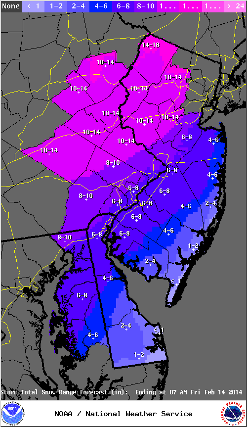
![]() by colosa4 Wed Feb 12, 2014 3:51 pm
by colosa4 Wed Feb 12, 2014 3:51 pm
http://www.erh.noaa.gov/okx/StormTotalPrecip/StormTotalSnowFcst.png
colosa4- Posts : 36
Reputation : 0
Join date : 2013-09-16
Location : Suffolk county/University at Buffalo
Re: 02/13 Godzilla Storm Obs. Thread / Final Discussions
![]() by NjWeatherGuy Wed Feb 12, 2014 3:51 pm
by NjWeatherGuy Wed Feb 12, 2014 3:51 pm
Mets2695 wrote:THEY UPPED! FRANK I THINK THEY SAW YOUR MAP!
They're leaning colder than Mt. Holly, maps are quite off if you put them side by side.
NjWeatherGuy- Advanced Forecaster
- Posts : 4100
Reputation : 28
Join date : 2013-01-06
Location : Belle Mead, NJ
Re: 02/13 Godzilla Storm Obs. Thread / Final Discussions
![]() by Frank_Wx Wed Feb 12, 2014 3:53 pm
by Frank_Wx Wed Feb 12, 2014 3:53 pm
_________________
_______________________________________________________________________________________________________
CLICK HERE to view NJ Strong Snowstorm Classifications
Frank_Wx- Godzilla Seeker
- Posts : 21305
Reputation : 328
Join date : 2013-01-05
Age : 31
Location : Jersey City, NJ -
Re: 02/13 Godzilla Storm Obs. Thread / Final Discussions
![]() by jmanley32 Wed Feb 12, 2014 3:53 pm
by jmanley32 Wed Feb 12, 2014 3:53 pm

jmanley32- Senior Enthusiast

- Posts : 20517
Reputation : 108
Join date : 2013-12-12
Age : 42
Location : Yonkers, NY
Re: 02/13 Godzilla Storm Obs. Thread / Final Discussions
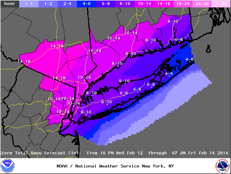
![]() by gigs68 Wed Feb 12, 2014 3:53 pm
by gigs68 Wed Feb 12, 2014 3:53 pm
http://www.erh.noaa.gov/okx/StormTotalPrecip/StormTotalSnowFcst.png

gigs68- Posts : 142
Reputation : 3
Join date : 2013-01-16
Location : Commack, NY (NW Suffolk)
Page 6 of 29 • 1 ... 5, 6, 7 ... 17 ... 29 ![]()