
 Search
Long Range Thread 8.0
Page 10 of 40 •  1 ... 6 ... 9, 10, 11 ... 25 ... 40
 ![]()
Re: Long Range Thread 8.0
![]() by dkodgis Fri Sep 11, 2015 8:35 am
by dkodgis Fri Sep 11, 2015 8:35 am
dkodgis- Senior Enthusiast

- Posts : 2503
Join date : 2013-12-29
Re: Long Range Thread 8.0
![]() by amugs Fri Sep 11, 2015 10:46 am
by amugs Fri Sep 11, 2015 10:46 am
Notice the red lines on the chart above - they are earlier forecasts that are higher in the chart, stronger nino period lasting much longer and being stronger as well as we hit December then falling/weaking.
The blue lines are the same forecast models but made in the last week - IF this is correct and only time will tell we seem to have peaked or there about November (hopefully earlier in the month and plausible at that!) which is earlier and not as strong as earlier shown.
Looks to be peaking around November but as Bill Goodman said sometimes the models lag what is actually happening at the surface. I have stated this before on here that IMHO I see a winter that start like this past winter in early to Mid Jan lasting until March. What I read this mornig was that the warmer waters are "going west" (young man) which could put us into what is called a Modoki Nino pattern:
Definition of what a Modoki EL Nino pattern is
An El Niño Modoki event is an anomalous condition of a distinctly different kind. The warmest SSTs occur in the central Pacific, flanked by colder waters to the east and west, and are associated with distinct patterns of atmospheric convection.
True EL Nino
Modoki
So what does this mean for us IF this is true?
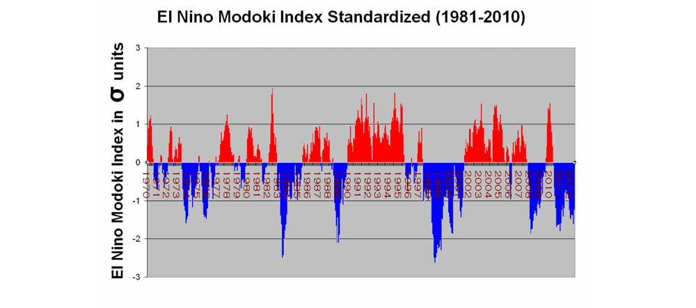
IT could very well mean a cold and snowy winter! The RED is a Modoki year and look at hose winters - cold and snowy! The analog years again are 2002-03, 2009-10 to look at for a somewhat comparison at this stage.
Snow extent comparisons between the years on Sept 10:
2015

2014

2013

Negligible at this time but this will be closely followed trough the upcoming fall because it is said to have an effect on the AO being positive and negative. Cohen has and is still doing research on this idea.
_________________
Mugs
AKA:King: Snow Weenie
Self Proclaimed
WINTER 2014-15 : 55.12" +.02 for 6 coatings (avg. 35")
WINTER 2015-16 Total - 29.8" (Avg 35")
WINTER 2016-17 : 39.5" so far

amugs- Advanced Forecaster - Mod

- Posts : 15093
Reputation : 213
Join date : 2013-01-07
Age : 54
Location : Hillsdale,NJ
Re: Long Range Thread 8.0
![]() by sroc4 Fri Sep 11, 2015 12:03 pm
by sroc4 Fri Sep 11, 2015 12:03 pm
_________________
"In weather and in life, there's no winning and losing; there's only winning and learning."
WINTER 2012/2013 TOTALS 43.65"WINTER 2017/2018 TOTALS 62.85" WINTER 2022/2023 TOTALS 4.9"
WINTER 2013/2014 TOTALS 64.85"WINTER 2018/2019 TOTALS 14.25" WINTER 2023/2024 TOTALS 13.1"
WINTER 2014/2015 TOTALS 71.20"WINTER 2019/2020 TOTALS 6.35"
WINTER 2015/2016 TOTALS 35.00"WINTER 2020/2021 TOTALS 37.75"
WINTER 2016/2017 TOTALS 42.25"WINTER 2021/2022 TOTALS 31.65"

sroc4- Admin

- Posts : 8331
Reputation : 301
Join date : 2013-01-07
Location : Wading River, LI
Re: Long Range Thread 8.0
![]() by sroc4 Fri Sep 11, 2015 12:08 pm
by sroc4 Fri Sep 11, 2015 12:08 pm
Frank_Wx wrote:Mugs, good post. Lots of good info in there. I have to do more research between the SAI and AO. I actually don't support the correlation as of now.sroc4 wrote:Even if the SST in the GOA cont to slowly erode we still may be ok. Remember the -EPO leads to the alaskan ridge which leads to the strong cross polar flow. BUT...the warm pool that is off the SW coast of Cali is not going anywhere (IMHO). This may lead to a persistantly +PNA which may still do us just fine. If we can get the NAO to cooperate some this year we should still be in business. Its all speculation and what not with many other factors to consider, but the + PDO IS going to flip...if not this year then within the next one or two again IMHO.
The PDO should keep our mean PNA postive. With the sub tropical jet roaring and an active MJO, I'm pretty confident in that. I'm more worried about there being cold air available though.
Agreed Frank. Since we are in a kind of a holding pattern right now I am going to try and find the time to research the winters with above normal siberian snow cover and the AO status vs snow fall amts relative to avg, and look at the relationships between the August into Sept pattern drivers and see if there are any linkage regarding what we can expect regarding the upcoming siberian snow cover anomalies.
_________________
"In weather and in life, there's no winning and losing; there's only winning and learning."
WINTER 2012/2013 TOTALS 43.65"WINTER 2017/2018 TOTALS 62.85" WINTER 2022/2023 TOTALS 4.9"
WINTER 2013/2014 TOTALS 64.85"WINTER 2018/2019 TOTALS 14.25" WINTER 2023/2024 TOTALS 13.1"
WINTER 2014/2015 TOTALS 71.20"WINTER 2019/2020 TOTALS 6.35"
WINTER 2015/2016 TOTALS 35.00"WINTER 2020/2021 TOTALS 37.75"
WINTER 2016/2017 TOTALS 42.25"WINTER 2021/2022 TOTALS 31.65"
sroc4- Admin
- Posts : 8331
Reputation : 301
Join date : 2013-01-07
Location : Wading River, LI
Re: Long Range Thread 8.0
![]() by algae888 Sat Sep 12, 2015 10:30 am
by algae888 Sat Sep 12, 2015 10:30 am

algae888- Advanced Forecaster

- Posts : 5311
Reputation : 46
Join date : 2013-02-05
Age : 61
Location : mt. vernon, new york
Re: Long Range Thread 8.0
![]() by nutleyblizzard Sat Sep 12, 2015 10:46 am
by nutleyblizzard Sat Sep 12, 2015 10:46 am
I wouldn't worry too much. With record setting -AO levels this past July, that bodes well for us this winter if you go by past history. I'd be more concerned with the Pacific to see where the best tropical forcing sets up. Too far east and we probably lose our source of cold air with the dreaded GOA low. We need the forcing to set up by the dateline to have a -EPO. As long as that happens, the Atlantic setup becomes less important.algae888 wrote:although temperatures have fallen off they are still above normal and next week temperatures look to get into the mid and high 80's again which is well above normal. It's a little concerning to me where temperatures are right now and no signs that this pattern is changing anytime soon. The Atlantic Ridge looks to be a problem for us this year

nutleyblizzard- Senior Enthusiast
- Posts : 1952
Reputation : 41
Join date : 2014-01-30
Age : 58
Location : Nutley, new jersey
Re: Long Range Thread 8.0
![]() by skinsfan1177 Sat Sep 12, 2015 11:12 am
by skinsfan1177 Sat Sep 12, 2015 11:12 am

skinsfan1177- Senior Enthusiast
- Posts : 4485
Reputation : 35
Join date : 2013-01-07
Age : 46
Location : Point Pleasant Boro
Re: Long Range Thread 8.0
![]() by sroc4 Sat Sep 12, 2015 12:59 pm
by sroc4 Sat Sep 12, 2015 12:59 pm
nutleyblizzard wrote:I wouldn't worry too much. With record setting -AO levels this past July, that bodes well for us this winter if you go by past history. I'd be more concerned with the Pacific to see where the best tropical forcing sets up. Too far east and we probably lose our source of cold air with the dreaded GOA low. We need the forcing to set up by the dateline to have a -EPO. As long as that happens, the Atlantic setup becomes less important.algae888 wrote:although temperatures have fallen off they are still above normal and next week temperatures look to get into the mid and high 80's again which is well above normal. It's a little concerning to me where temperatures are right now and no signs that this pattern is changing anytime soon. The Atlantic Ridge looks to be a problem for us this year
Must keep in mind that the same drivers do different things to the pattern different times of the year. Not worried at all at this stage.
_________________
"In weather and in life, there's no winning and losing; there's only winning and learning."
WINTER 2012/2013 TOTALS 43.65"WINTER 2017/2018 TOTALS 62.85" WINTER 2022/2023 TOTALS 4.9"
WINTER 2013/2014 TOTALS 64.85"WINTER 2018/2019 TOTALS 14.25" WINTER 2023/2024 TOTALS 13.1"
WINTER 2014/2015 TOTALS 71.20"WINTER 2019/2020 TOTALS 6.35"
WINTER 2015/2016 TOTALS 35.00"WINTER 2020/2021 TOTALS 37.75"
WINTER 2016/2017 TOTALS 42.25"WINTER 2021/2022 TOTALS 31.65"
sroc4- Admin
- Posts : 8331
Reputation : 301
Join date : 2013-01-07
Location : Wading River, LI
Re: Long Range Thread 8.0
![]() by sroc4 Sun Sep 13, 2015 8:55 am
by sroc4 Sun Sep 13, 2015 8:55 am
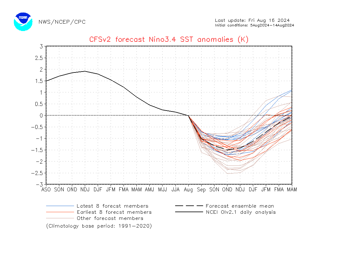
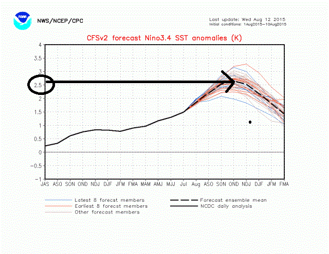
amugs wrote:Thanks guys for the comments on my pamphlet post above. Interesting to see this chart just put out by NCEP.
Notice the red lines on the chart above - they are earlier forecasts that are higher in the chart, stronger nino period lasting much longer and being stronger as well as we hit December then falling/weaking.
The blue lines are the same forecast models but made in the last week - IF this is correct and only time will tell we seem to have peaked or there about November (hopefully earlier in the month and plausible at that!) which is earlier and not as strong as earlier shown.
Looks to be peaking around November but as Bill Goodman said sometimes the models lag what is actually happening at the surface. I have stated this before on here that IMHO I see a winter that start like this past winter in early to Mid Jan lasting until March. What I read this mornig was that the warmer waters are "going west" (young man) which could put us into what is called a Modoki Nino pattern:
Just to expand a bit on this image that Mugsy posted on the 11th. Similar to when we are tracking a winter storm, looking for trends within a model can help guide us in the direction a certain outcome is headed. The images below represent the CFSv2 models SST anomaly predictions for Nino region3.4.

To reiterate what Mugs posted above the Blue lines on the images are the most recent model runs and the red lines are the older ones and gray lines are older yet. The thin solid black line was the actual observed value, and the dashed black line is the predicted value based on the avg of all the most recent runs(blue, red and gray lines). Credit for this post goes to Joe Bastardi who posted these images on the Bell on the 11th.
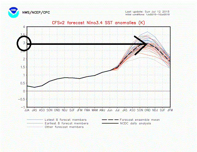
First image was from July12th. Notice the predicted peak is up at 3 standard deviations above normal. Also take note at where the blue lines are located (most recent runs as of July 12th)...above the avg predicted.
 " />
" />Second image August 12th.
 " />
" />Third image was the most recent from Sept 11th(Never forget).
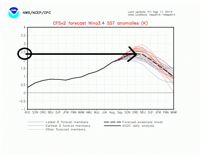 " />
" />So as you can see there is a clear shift/trend to a weaker, albeit still mod to strong values, event over the last 2 months peaking during the Oct, Nov, Dec (OND) time frame. In theory better for the NE. The predicted peak has trended weaker from 3 standard deviations to currently just under 2.5 with the most recent cluster of blue lines below the avg predicted value meaning we MAY cont to see the Nino event trend weaker over the next month or two.
A few key points to remember:
1) This is only looking at one Nino region (3.4)
2) This is only the trend of one model, not a reality. There is time for things to trend differently
3) As a general rule if the current trend above were to in fact come to fruition it would increase the chances for less wet and more white in the NE; however, the status of the El Nino is only one of MANY factors that will influence the overall pattern for this upcoming winter.
So in conclusion I am bored of this boring weather
PS...FOOTBALL SUNDAY!!!!!! GO GGGGGMMMMMEEEEENNNNN!!!!!!!!!!!!!!!
_________________
"In weather and in life, there's no winning and losing; there's only winning and learning."
WINTER 2012/2013 TOTALS 43.65"WINTER 2017/2018 TOTALS 62.85" WINTER 2022/2023 TOTALS 4.9"
WINTER 2013/2014 TOTALS 64.85"WINTER 2018/2019 TOTALS 14.25" WINTER 2023/2024 TOTALS 13.1"
WINTER 2014/2015 TOTALS 71.20"WINTER 2019/2020 TOTALS 6.35"
WINTER 2015/2016 TOTALS 35.00"WINTER 2020/2021 TOTALS 37.75"
WINTER 2016/2017 TOTALS 42.25"WINTER 2021/2022 TOTALS 31.65"
sroc4- Admin
- Posts : 8331
Reputation : 301
Join date : 2013-01-07
Location : Wading River, LI
Re: Long Range Thread 8.0
![]() by Guest Mon Sep 14, 2015 11:13 am
by Guest Mon Sep 14, 2015 11:13 am
Guest- Guest
Re: Long Range Thread 8.0
![]() by sroc4 Mon Sep 14, 2015 11:47 am
by sroc4 Mon Sep 14, 2015 11:47 am
syosnow94 wrote:Great post sroc. But holy crap your gmen s%#t the bed. The coach should be fired. Didn't he watch the superbowl? Horrible clock management.
Uggg dont get me started.

 Im ok with the play call as long as your QB knows to take the sack instead of stop the clock by throwing it away.
 _________________
"In weather and in life, there's no winning and losing; there's only winning and learning."
WINTER 2012/2013 TOTALS 43.65"WINTER 2017/2018 TOTALS 62.85" WINTER 2022/2023 TOTALS 4.9"
WINTER 2013/2014 TOTALS 64.85"WINTER 2018/2019 TOTALS 14.25" WINTER 2023/2024 TOTALS 13.1"
WINTER 2014/2015 TOTALS 71.20"WINTER 2019/2020 TOTALS 6.35"
WINTER 2015/2016 TOTALS 35.00"WINTER 2020/2021 TOTALS 37.75"
WINTER 2016/2017 TOTALS 42.25"WINTER 2021/2022 TOTALS 31.65"
sroc4- Admin
- Posts : 8331
Reputation : 301
Join date : 2013-01-07
Location : Wading River, LI
Re: Long Range Thread 8.0
![]() by Frank_Wx Mon Sep 14, 2015 7:25 pm
by Frank_Wx Mon Sep 14, 2015 7:25 pm
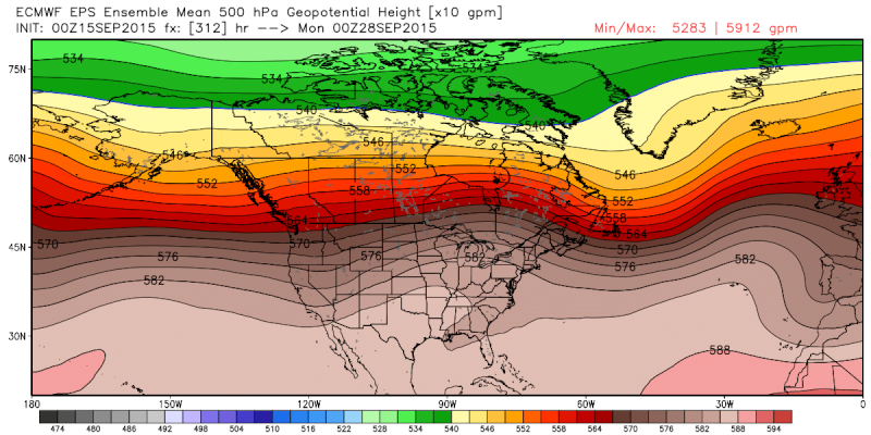
And if the EURO has its way...we're not going to see below normal temps for awhile. Will remain average to above for the foreseeable future.
_________________
_______________________________________________________________________________________________________
CLICK HERE to view NJ Strong Snowstorm Classifications

Frank_Wx- Godzilla Seeker
- Posts : 21305
Reputation : 328
Join date : 2013-01-05
Age : 31
Location : Jersey City, NJ -

Re: Long Range Thread 8.0
![]() by Quietace Tue Sep 15, 2015 2:25 pm
by Quietace Tue Sep 15, 2015 2:25 pm
Wake Me Up When September Ends....Frank_Wx wrote:After a short stretch of fall-like weather, we'll return to temps in the mid 80s tomorrow through the rest of the week. Some spots will approach 90 degrees but not quite sure they get there. Huge trough in the west will lead to higher than normal heights over the east.
And if the EURO has its way...we're not going to see below normal temps for awhile. Will remain average to above for the foreseeable future.

Quietace- Meteorologist - Mod

- Posts : 3687
Reputation : 33
Join date : 2013-01-07
Age : 27
Location : Point Pleasant, NJ
Re: Long Range Thread 8.0
![]() by Frank_Wx Tue Sep 15, 2015 7:55 pm
by Frank_Wx Tue Sep 15, 2015 7:55 pm
_________________
_______________________________________________________________________________________________________
CLICK HERE to view NJ Strong Snowstorm Classifications
Frank_Wx- Godzilla Seeker
- Posts : 21305
Reputation : 328
Join date : 2013-01-05
Age : 31
Location : Jersey City, NJ -
Re: Long Range Thread 8.0
![]() by Frank_Wx Tue Sep 15, 2015 7:57 pm
by Frank_Wx Tue Sep 15, 2015 7:57 pm
_________________
_______________________________________________________________________________________________________
CLICK HERE to view NJ Strong Snowstorm Classifications
Frank_Wx- Godzilla Seeker
- Posts : 21305
Reputation : 328
Join date : 2013-01-05
Age : 31
Location : Jersey City, NJ -
Re: Long Range Thread 8.0
![]() by algae888 Wed Sep 16, 2015 4:10 pm
by algae888 Wed Sep 16, 2015 4:10 pm
nws disco...
TEMPS DURING THE PERIOD WILL START OFF ABOVE NORMAL ON FRIDAY AND
SATURDAY BEFORE FALLING BACK TO NORMAL...AND MAYBE A COUPLE OF
DEGREES BELOW NORMAL FOR THE UPCOMING WEEK.
algae888- Advanced Forecaster
- Posts : 5311
Reputation : 46
Join date : 2013-02-05
Age : 61
Location : mt. vernon, new york
Re: Long Range Thread 8.0
![]() by algae888 Wed Sep 16, 2015 4:20 pm
by algae888 Wed Sep 16, 2015 4:20 pm

algae888- Advanced Forecaster
- Posts : 5311
Reputation : 46
Join date : 2013-02-05
Age : 61
Location : mt. vernon, new york
Re: Long Range Thread 8.0
![]() by algae888 Wed Sep 16, 2015 4:24 pm
by algae888 Wed Sep 16, 2015 4:24 pm
algae888- Advanced Forecaster
- Posts : 5311
Reputation : 46
Join date : 2013-02-05
Age : 61
Location : mt. vernon, new york
Re: Long Range Thread 8.0
![]() by sroc4 Wed Sep 16, 2015 4:57 pm
by sroc4 Wed Sep 16, 2015 4:57 pm
algae888 wrote:looking at the last half of sept, after this Friday we can say goodbye to the 80's.


_________________
"In weather and in life, there's no winning and losing; there's only winning and learning."
WINTER 2012/2013 TOTALS 43.65"WINTER 2017/2018 TOTALS 62.85" WINTER 2022/2023 TOTALS 4.9"
WINTER 2013/2014 TOTALS 64.85"WINTER 2018/2019 TOTALS 14.25" WINTER 2023/2024 TOTALS 13.1"
WINTER 2014/2015 TOTALS 71.20"WINTER 2019/2020 TOTALS 6.35"
WINTER 2015/2016 TOTALS 35.00"WINTER 2020/2021 TOTALS 37.75"
WINTER 2016/2017 TOTALS 42.25"WINTER 2021/2022 TOTALS 31.65"
sroc4- Admin
- Posts : 8331
Reputation : 301
Join date : 2013-01-07
Location : Wading River, LI
Re: Long Range Thread 8.0
![]() by amugs Thu Sep 17, 2015 9:52 am
by amugs Thu Sep 17, 2015 9:52 am
Good news that the sea ice extent has reached a minimum and now we are starting to see the buildup of ice in the arctic region.
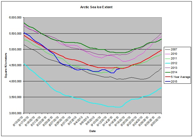
Very Nice uptick in this region – like the comeback kid and as I posted in an earlier post that the series of LP systems in the region would help the ice build back. A good trend at this point.
Compare ice coverage - picking up
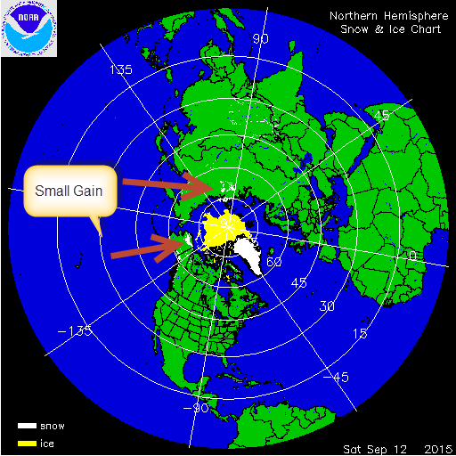

You can see the increase in small quantities but nevertheless it is increasing. The conditions are starting to become more favorable for snow and ice growth in the arctic region as we are steadily reaching Fall. I will do another comparison towards the end of the month.
_________________
Mugs
AKA:King: Snow Weenie
Self Proclaimed
WINTER 2014-15 : 55.12" +.02 for 6 coatings (avg. 35")
WINTER 2015-16 Total - 29.8" (Avg 35")
WINTER 2016-17 : 39.5" so far
amugs- Advanced Forecaster - Mod
- Posts : 15093
Reputation : 213
Join date : 2013-01-07
Age : 54
Location : Hillsdale,NJ
Re: Long Range Thread 8.0
![]() by sroc4 Thu Sep 17, 2015 10:28 am
by sroc4 Thu Sep 17, 2015 10:28 am
amugs wrote:
Good news that the sea ice extent has reached a minimum and now we are starting to see the buildup of ice in the arctic region.
Very Nice uptick in this region – like the comeback kid and as I posted in an earlier post that the series of LP systems in the region would help the ice build back. A good trend at this point.
Compare ice coverage - picking up
You can see the increase in small quantities but nevertheless it is increasing. The conditions are starting to become more favorable for snow and ice growth in the arctic region as we are steadily reaching Fall. I will do another comparison towards the end of the month.
Love these posts
_________________
"In weather and in life, there's no winning and losing; there's only winning and learning."
WINTER 2012/2013 TOTALS 43.65"WINTER 2017/2018 TOTALS 62.85" WINTER 2022/2023 TOTALS 4.9"
WINTER 2013/2014 TOTALS 64.85"WINTER 2018/2019 TOTALS 14.25" WINTER 2023/2024 TOTALS 13.1"
WINTER 2014/2015 TOTALS 71.20"WINTER 2019/2020 TOTALS 6.35"
WINTER 2015/2016 TOTALS 35.00"WINTER 2020/2021 TOTALS 37.75"
WINTER 2016/2017 TOTALS 42.25"WINTER 2021/2022 TOTALS 31.65"
sroc4- Admin
- Posts : 8331
Reputation : 301
Join date : 2013-01-07
Location : Wading River, LI
Re: Long Range Thread 8.0
![]() by amugs Thu Sep 17, 2015 1:43 pm
by amugs Thu Sep 17, 2015 1:43 pm


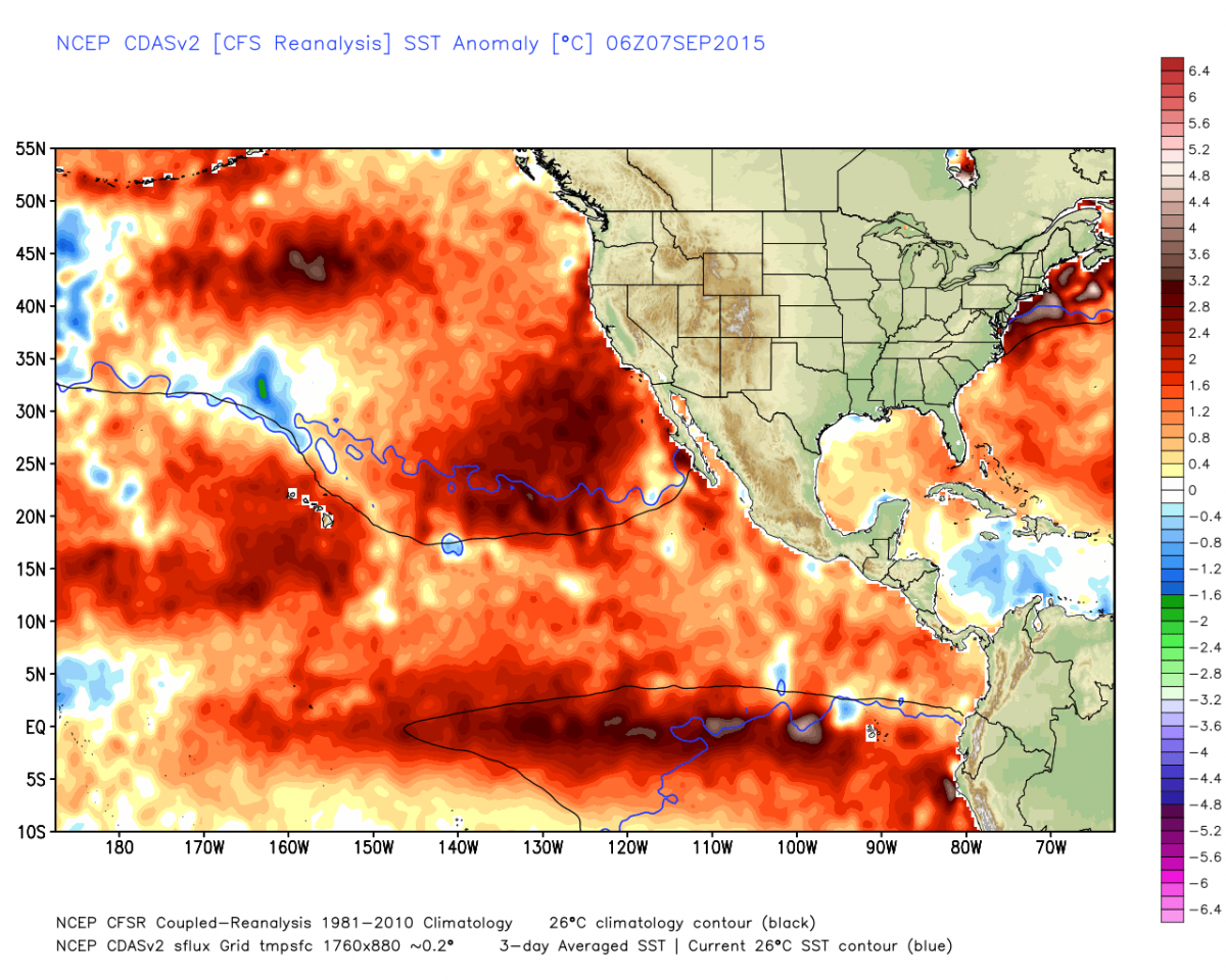
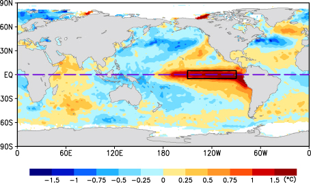
Looking pretty good at this point - ALOT of TIME to go though but the westward expansion and movement of these spa like waters is good news for the incoming winter at this time.
_________________
Mugs
AKA:King: Snow Weenie
Self Proclaimed
WINTER 2014-15 : 55.12" +.02 for 6 coatings (avg. 35")
WINTER 2015-16 Total - 29.8" (Avg 35")
WINTER 2016-17 : 39.5" so far
amugs- Advanced Forecaster - Mod
- Posts : 15093
Reputation : 213
Join date : 2013-01-07
Age : 54
Location : Hillsdale,NJ
Re: Long Range Thread 8.0
![]() by amugs Thu Sep 17, 2015 1:46 pm
by amugs Thu Sep 17, 2015 1:46 pm
_________________
Mugs
AKA:King: Snow Weenie
Self Proclaimed
WINTER 2014-15 : 55.12" +.02 for 6 coatings (avg. 35")
WINTER 2015-16 Total - 29.8" (Avg 35")
WINTER 2016-17 : 39.5" so far
amugs- Advanced Forecaster - Mod
- Posts : 15093
Reputation : 213
Join date : 2013-01-07
Age : 54
Location : Hillsdale,NJ
Re: Long Range Thread 8.0
![]() by amugs Thu Sep 17, 2015 1:50 pm
by amugs Thu Sep 17, 2015 1:50 pm

_________________
Mugs
AKA:King: Snow Weenie
Self Proclaimed
WINTER 2014-15 : 55.12" +.02 for 6 coatings (avg. 35")
WINTER 2015-16 Total - 29.8" (Avg 35")
WINTER 2016-17 : 39.5" so far
amugs- Advanced Forecaster - Mod
- Posts : 15093
Reputation : 213
Join date : 2013-01-07
Age : 54
Location : Hillsdale,NJ
Re: Long Range Thread 8.0
![]() by Frank_Wx Thu Sep 17, 2015 7:46 pm
by Frank_Wx Thu Sep 17, 2015 7:46 pm
_________________
_______________________________________________________________________________________________________
CLICK HERE to view NJ Strong Snowstorm Classifications
Frank_Wx- Godzilla Seeker
- Posts : 21305
Reputation : 328
Join date : 2013-01-05
Age : 31
Location : Jersey City, NJ -
Page 10 of 40 • 1 ... 6 ... 9, 10, 11 ... 25 ... 40 ![]()
|
|
|